Overview
Temperatures climbing into the low to mid 90s with dew points in the low to mid 70s Tuesday afternoon lead to heat indices reaching around 100 degrees across most of southeast Michigan. This hot and humid airmass fueled an expanding line of strong to severe thunderstorms which moved through southeast Michigan just before 4 PM and 7 PM. Wind gusts of 40-65 MPH impacted the majority of southeast Michigan, downing tree limbs and trees. Isolated stronger gusts between 66-76 mph were also observed across the Detroit Metro Area. In total, about 380,000 customers lost power in Michigan, with around 210,000 in the DTE service area/southeast Michigan region. Just about every county in southeast Michigan experienced at least minor tree damage. Due to the rapid movement of the line of thunderstorms, rainfall totals were limited to under 1 inch across the majority of the area. Much heavier rainfall occurred with thunderstorms moving through Washtenaw and Wayne counties Tuesday night, leading to total rainfall totals around 3 inches in Ann Arbor.
Photos
 |
 |
 |
|
Sebewaing Credit: Phill Wilson |
Sebewaing Credit: Phill Wilson |
Burton Credit: Christopher Vogt |
Radar
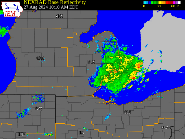
Radar loop courtesy of Iowa Environmental Mesonet (IEM)
Storm Reports
|
|
|
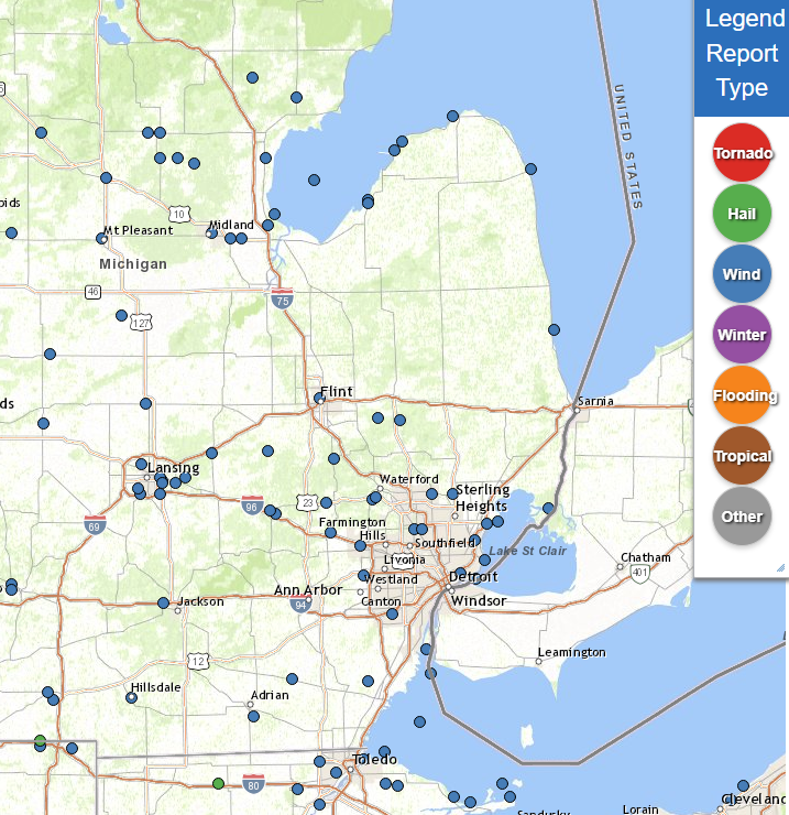
Map of Local Storm Reports August 27, 2024 |
Severe Weather Local Storm Reports:
Preliminary Local Storm Report...Summary
National Weather Service Detroit/Pontiac MI
1203 PM EDT Wed Aug 28 2024

..TIME...   ...EVENT...      ...CITY LOCATION...     ...LAT.LON...
..DATE...   ....MAG....      ..COUNTY LOCATION..ST.. ...SOURCE....
            ..REMARKS..

0354 PM     Tstm Wnd Dmg     Midland                 43.62N  84.23W
08/27/2024                   Midland            MI   Trained Spotter

            Trees down near US 10 Business loop and Eastman Rd.

0401 PM     Tstm Wnd Gst     3 W Auburn              43.60N  84.14W
08/27/2024  M62 mph          Bay                MI   Dept of Highways

0405 PM     Tstm Wnd Dmg     2 N Pinconning          43.89N  83.96W
08/27/2024                   Bay                MI   Trained Spotter

            One large tree down as well as a large limb over 6
            inches in diameter.

0406 PM     Tstm Wnd Dmg     Auburn                  43.60N  84.08W
08/27/2024                   Bay                MI   Trained Spotter

            large tree uprooted on Garfield Rd just south of US 10.

0409 PM     Tstm Wnd Dmg     Kawkawlin               43.65N  83.95W
08/27/2024                   Bay                MI   Amateur Radio

            Multiple reports of trees and power lines down along
            Beaver Road.

0409 PM     Tstm Wnd Gst     Tri Cities Intl Airport 43.53N  84.08W
08/27/2024  M62 mph          Saginaw            MI   ASOS

0415 PM     Marine Tstm Wind Killarney Beach         43.69N  83.92W
08/27/2024  M46 mph          Bay                MI   Park/Forest Srvc

0420 PM     Marine Tstm Wind Saginaw Bay South       43.81N  83.72W
08/27/2024  M47 mph          LHZ422             MI   C-Man Station

0430 PM     Tstm Wnd Dmg     Sebewaing               43.73N  83.45W
08/27/2024                   Huron              MI   Trained Spotter

            Multiple 3+ inch tree limbs down.

0440 PM     Tstm Wnd Dmg     1 NE Sebewaing          43.74N  83.45W
08/27/2024                   Huron              MI   Trained Spotter

            Large tree down across Center St near M25 and Beck

0445 PM     Tstm Wnd Dmg     Perry                   42.82N  84.23W
08/27/2024                   Shiawassee         MI   Trained Spotter

            Multiple trees down. At least one tree damaged a home.

0446 PM     Marine Tstm Wind 2 E Sand Point          43.92N  83.32W
08/27/2024  M43 mph          Huron              MI   Mesonet

0450 PM     Tstm Wnd Gst     Caseville Light         43.95N  83.28W
08/27/2024  M67 mph          LHZ421             MI   C-Man Station

0459 PM     Tstm Wnd Dmg     Howell                  42.61N  83.94W
08/27/2024                   Livingston         MI   911 Call Center

            Numerous trees down across Livingston County per
            dispatch.

0500 PM     Tstm Wnd Dmg     Byron                   42.83N  83.95W
08/27/2024                   Shiawassee         MI   Trained Spotter

            At least 4 large trees down in and south of the
            downtown area.

0502 PM     Tstm Wnd Dmg     2 SE Howell             42.60N  83.91W
08/27/2024                   Livingston         MI   NWS Employee

            Large tree limbs reported down.

0505 PM     Tstm Wnd Gst     Flint                   43.02N  83.69W
08/27/2024  M63 mph          Genesee            MI   ASOS

            Gust measured at Flint Bishop Airport

0510 PM     Marine Tstm Wind 2 W Port Austin         44.04N  83.03W
08/27/2024  M46 mph          Huron              MI   Mesonet

0515 PM     Tstm Wnd Dmg     2 W Highland            42.64N  83.66W
08/27/2024                   Oakland            MI   NWS Employee

            Trees and tree limbs reported down.

0518 PM     Marine Tstm Wind 1 E Harbor Beach        43.85N  82.64W
08/27/2024  M48 mph          Huron              MI   C-Man Station

0520 PM     Marine Tstm Wind Lexington Harbor        43.27N  82.52W
08/27/2024  M44 mph          Sanilac            MI   Mesonet

0520 PM     Tstm Wnd Dmg     Hadley                  42.95N  83.40W
08/27/2024                   Lapeer             MI   NWS Employee

            Four trees reported blown down.

0520 PM     Tstm Wnd Dmg     2 NW New Hudson         42.53N  83.64W
08/27/2024                   Oakland            MI   Public

            Large trees downed at Kensington Park.

0525 PM     Tstm Wnd Gst     4 E White Lake          42.65N  83.43W
08/27/2024  M67 mph          Oakland            MI   Official NWS Obs

0525 PM     Tstm Wnd Dmg     Metamora                42.94N  83.29W
08/27/2024                   Lapeer             MI   911 Call Center

            Numerous trees down all across southern Lapeer County.

0531 PM     Tstm Wnd Dmg     Holly                   42.80N  83.62W
08/27/2024                   Oakland            MI   NWS Employee

            More than a dozen trees down between Holly and the
            Oakland/Genessee County line.

0533 PM     Tstm Wnd Gst     Oakland County Intl Air 42.66N  83.41W
08/27/2024  M66 mph          Oakland            MI   ASOS

0540 PM     Tstm Wnd Dmg     2 W Ann Arbor           42.28N  83.77W
08/27/2024                   Washtenaw          MI   911 Call Center

            Trees and power lines reported down across many parts
            of Washtenaw county, but especially Scio Township and
            Ann Arbor area. A few trees also landed on houses and
            cars.

0545 PM     Tstm Wnd Dmg     Novi                    42.48N  83.49W
08/27/2024                   Oakland            MI   Trained Spotter

            Multiple trees and tree limbs down in and around Novi.
            Reported via Twitter/X

0549 PM     Tstm Wnd Dmg     1 NE Rochester Hills    42.67N  83.13W
08/27/2024                   Oakland            MI   NWS Employee

            4 or more powerpoles snapped. Also small tree debris
            all over the area.

0550 PM     Tstm Wnd Dmg     Shelby Township         42.67N  83.03W
08/27/2024                   Macomb             MI   NWS Employee

            2 large trees down along Southfield Dr.

0555 PM     Tstm Wnd Gst     Oakland Troy Airport    42.54N  83.18W
08/27/2024  M58 mph          Oakland            MI   AWOS

0555 PM     Tstm Wnd Gst     Detroit Metro Intl Airp 42.23N  83.33W
08/27/2024  M76 mph          Wayne              MI   ASOS

0557 PM     Tstm Wnd Dmg     Birmingham              42.54N  83.22W
08/27/2024                   Oakland            MI   Trained Spotter

            Large tree uprooted and fell across Pine St.

0601 PM     Marine Tstm Wind 1 SW Lakeside           42.56N  82.86W
08/27/2024  M45 mph          Macomb             MI   Dept of Highways

0604 PM     Tstm Wnd Dmg     2 S Detroit City Airpor 42.38N  82.99W
08/27/2024                   Wayne              MI   Public

            Large tree uprooted and fell across the road near
            Cadillac and Forest.

0605 PM     Marine Tstm Wind Lake St. Clair Metropar 42.57N  82.80W
08/27/2024  M44 mph          Macomb             MI   Mesonet

0605 PM     Marine Tstm Wind Grosse Pointe YC        42.43N  82.87W
08/27/2024  M50 mph          LCZ460             MI   Mesonet

0609 PM     Tstm Wnd Dmg     Britton                 41.99N  83.83W
08/27/2024                   Lenawee            MI   911 Call Center

            Multiple trees down

0610 PM     Marine Tstm Wind 1 W Algonac             42.62N  82.55W
08/27/2024  M48 mph          St. Clair          MI   Mesonet

0611 PM     Tstm Wnd Gst     1 E Roseville           42.50N  82.92W
08/27/2024  M75 mph          Macomb             MI   Dept of Highways

0615 PM     Marine Tstm Wind Peche Island Light      42.36N  82.91W
08/27/2024  M57 mph          LCZ460             MI   Mesonet

0615 PM     Marine Tstm Wind Grosse Ille             42.10N  83.16W
08/27/2024  M47 mph          Wayne              MI   AWOS

0620 PM     Tstm Wnd Dmg     3 N Monroe Custer Airpo 41.98N  83.45W
08/27/2024                   Monroe             MI   Amateur Radio

            Numerous trees down across the county, especially north
            of the city of Monroe.

0629 PM     Marine Tstm Wind 1 N Detroit River Light 42.01N  83.14W
08/27/2024  M53 mph          LEZ444             MI   Mesonet

0633 PM     Tstm Wnd Dmg     3 NE Fairfield          41.85N  84.02W
08/27/2024                   Lenawee            MI   911 Call Center

            Multiple trees down around the area

0228 AM     Tstm Wnd Dmg     Plymouth                42.37N  83.47W
08/28/2024                   Wayne              MI   Broadcast Media

            Wet mirco-burst downed trees in Plymouth.


&&
 |
|
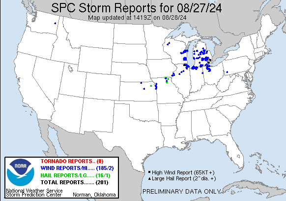
National Storm Reports for August 27, 2024 |
Environment
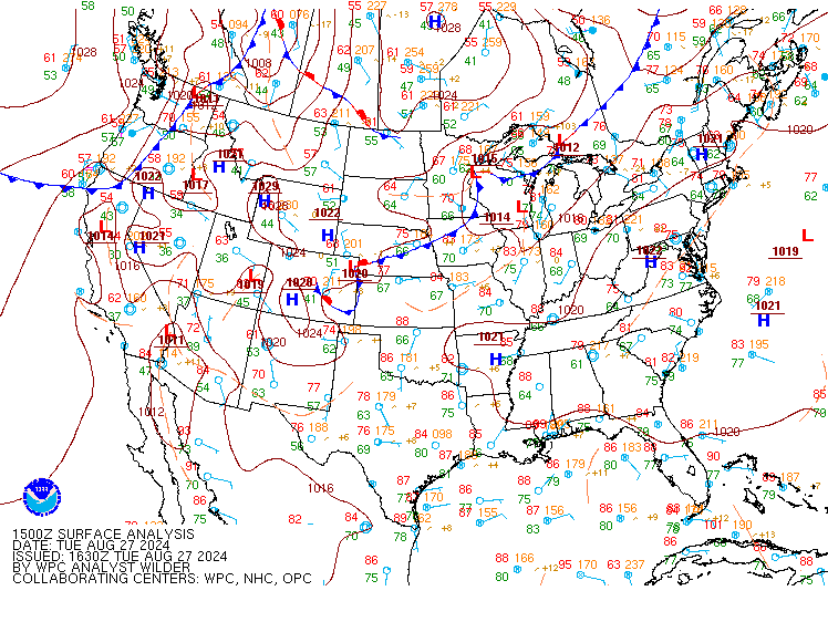
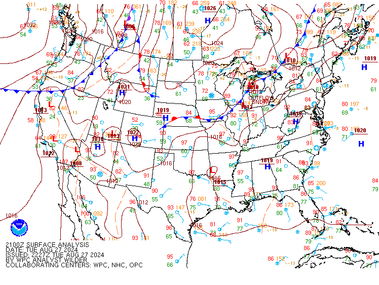
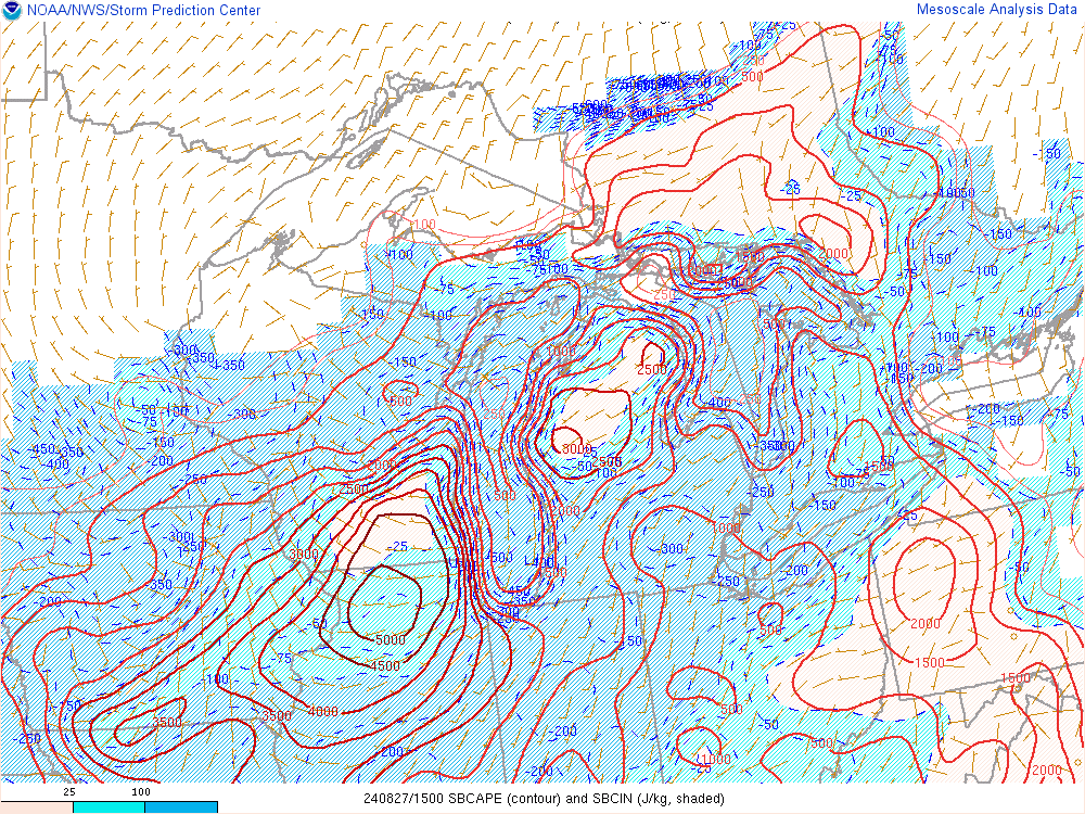
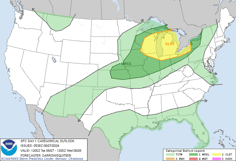
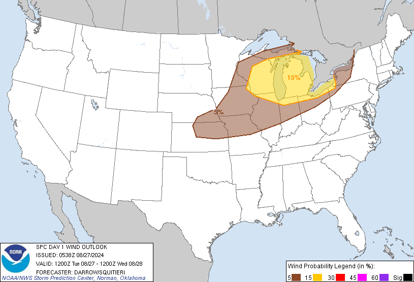
A cold frontal boundary sagging south through the upper Great Lakes spurred the development of an MCS over northeastern Wisconsin during the late morning hours of the 27th. This complex tracked east into northwest lower Michigan before diving southeast to southeastern Michigan early in the afternoon due to a strong developing CAPE gradient over lower Michigan. Strong southerly flow had advected a very hot, humid airmass into lower Michigan with most locales seeing dewpoints in the mid 70s as temperatures reached into the lower 90s. Surface based instability reached or exceeded 3500 J/kg due to this airmass and provided ample support for not only maintenance of the MCS but further upscale growth to expand across the entirety of southern lower Michigan during the afternoon.
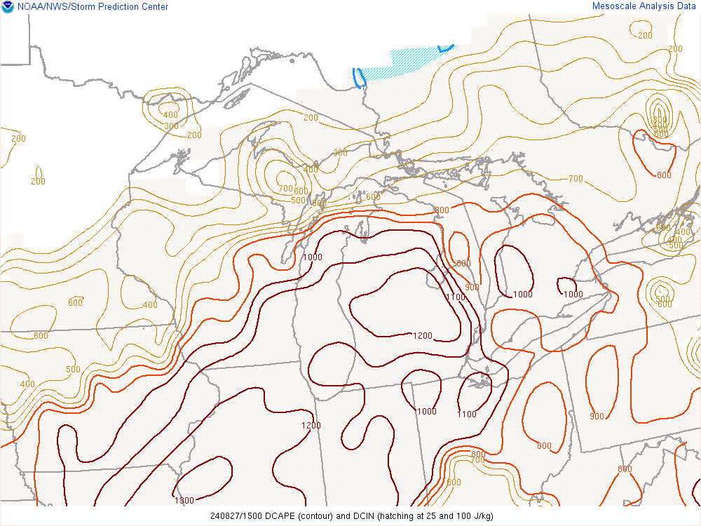
Mature cold pool formation coincided with strengthening DCAPEs which ranged from 1000-1500 J/kg as it reached the I-69 corridor. 60+ mph wind gusts were observed from Saginaw down to Flint during this time with winds further increasing as the mature organized line pushed into the greater Metro Detroit area. Peak gusts were observed over Detroit itself with 75 mph measured at a mesonet site near Roseville and 76 mph at Detroit Metro Airport. While some weakening of the line occurred after this point due to decreasing instability during the evening hours, damaging winds continued all the way to the Ohio border before the line pushed south and east the region by 8 PM though trailing stratiform rain would linger for a couple more hours into the late evening. Despite the humid airmass and PW values between 1.5-2", the progressive nature of the line limited the residence time over any one area keeping rain amounts generally at or below 1 inch.
 |
 |
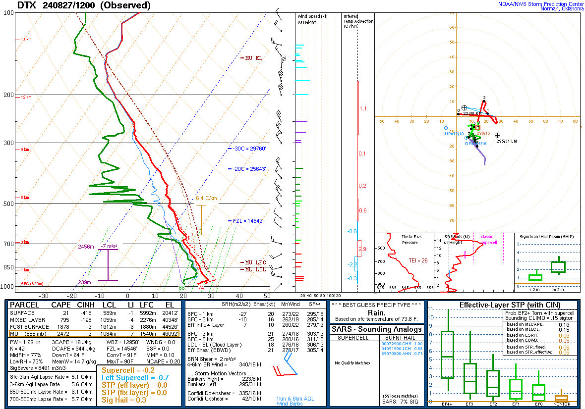 |
| Figure 1: WPC Surface Analysis, valid 1500 UTC 27 Aug 2024 | Figure 2: WPC Surface Analysis, valid 2100 UTC 27 Aug 2024 | Figure 3: DTX Sounding, valid 1200 UTC 27 Aug 2024 |
 |
 |
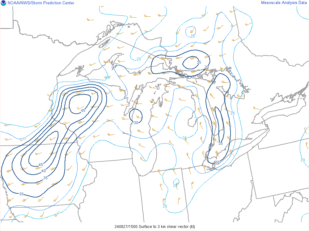 |
| Figure 4: Surface Based CAPE, valid 1500 to 2300 UTC 27 Aug 2024 | Figure 5: Downdraft CAPE, valid 1500 to 2300 UTC 27 Aug 2024 | Figure 6: 0-3km Wind Shear, valid 1500 to 2300 UTC 27 Aug 2024 |
 |
 |
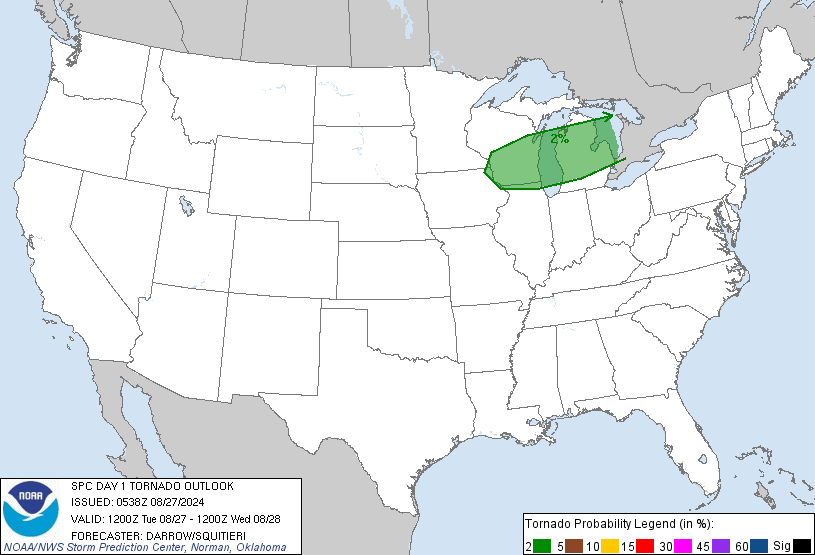 |
| Figure 7: SPC Day 1 Severe Weather Outlook, valid 1200 UTC 27 Aug 2024 | Figure 8: SPC Day 1 Probabilistic Wind Outlook, valid 1200 UTC 27 Aug 2024 | Figure 9: SPC Day 1 Probabilistic Tornado Outlook, valid 1200 UTC 27 Aug 2024 |
 |
Media use of NWS Web News Stories is encouraged! Please acknowledge the NWS as the source of any news information accessed from this site. |
|