Overview
A line of thunderstorms developed ahead of a frontal boundary and moved across Lake Michigan during the morning hours of July 26, 2023. These thunderstorms would eventually track across the state into a very warm and unstable environment, which promoted the issuance of a Severe Thunderstorm Watch for all of southeast Michigan. The southern end of the line of storms is where the strongest winds associated with the line would develop and moved across the lower portions of southeast Michigan during the afternoon between 2 PM and 5 PM. A swath of widespread 60-70 mph wind gusts with locally higher gusts resulted in numerous downed trees, downed powerlines, and around 165,000 power outages in southeast Michigan. The Ann Arbor and the Detroit/Grosse Pointe areas were hit the hardest.
Photos
 |
 |
 |
|
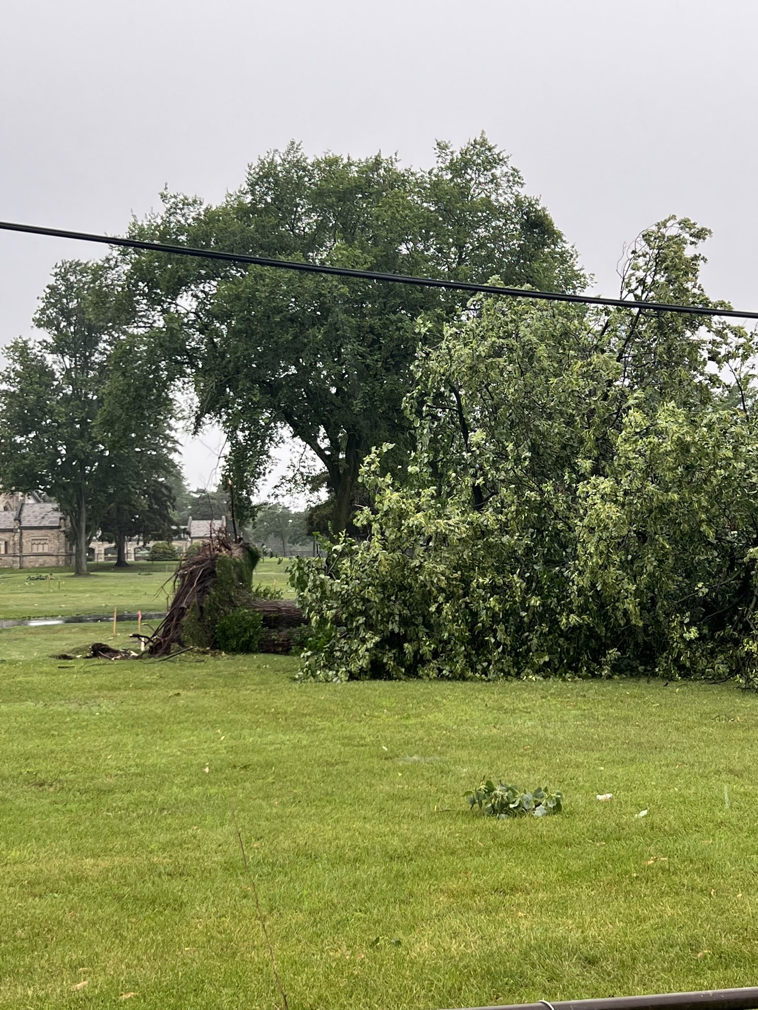
Grosse Pointe Credit: Jess (@3rdCoastalElite-Twitter) |
Grosse Pointe Farms Credit: Ben Mackenzie via Ahmad Bajjey |
Grosse Pointe Farms Credit: Ben Mackenzie via Ahmad Bajjey |
 |
 |
 |
|
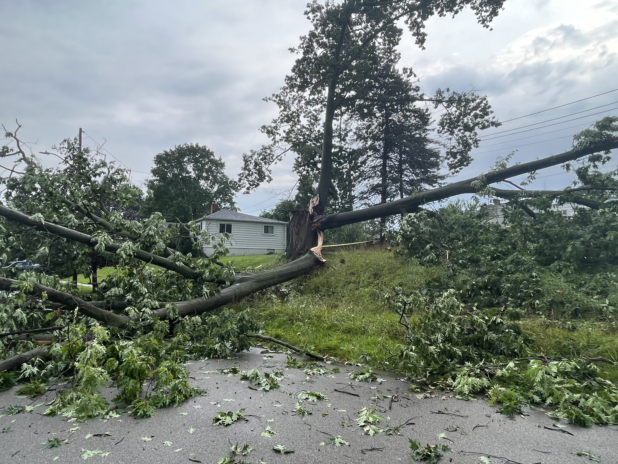
Livonia Credit: Gracie Bazzell |
Luna Pier Credit: Holly LaMontagne |
Redford Township Credit: Ron Hilliard WDIV |
 |
 |
 |
|
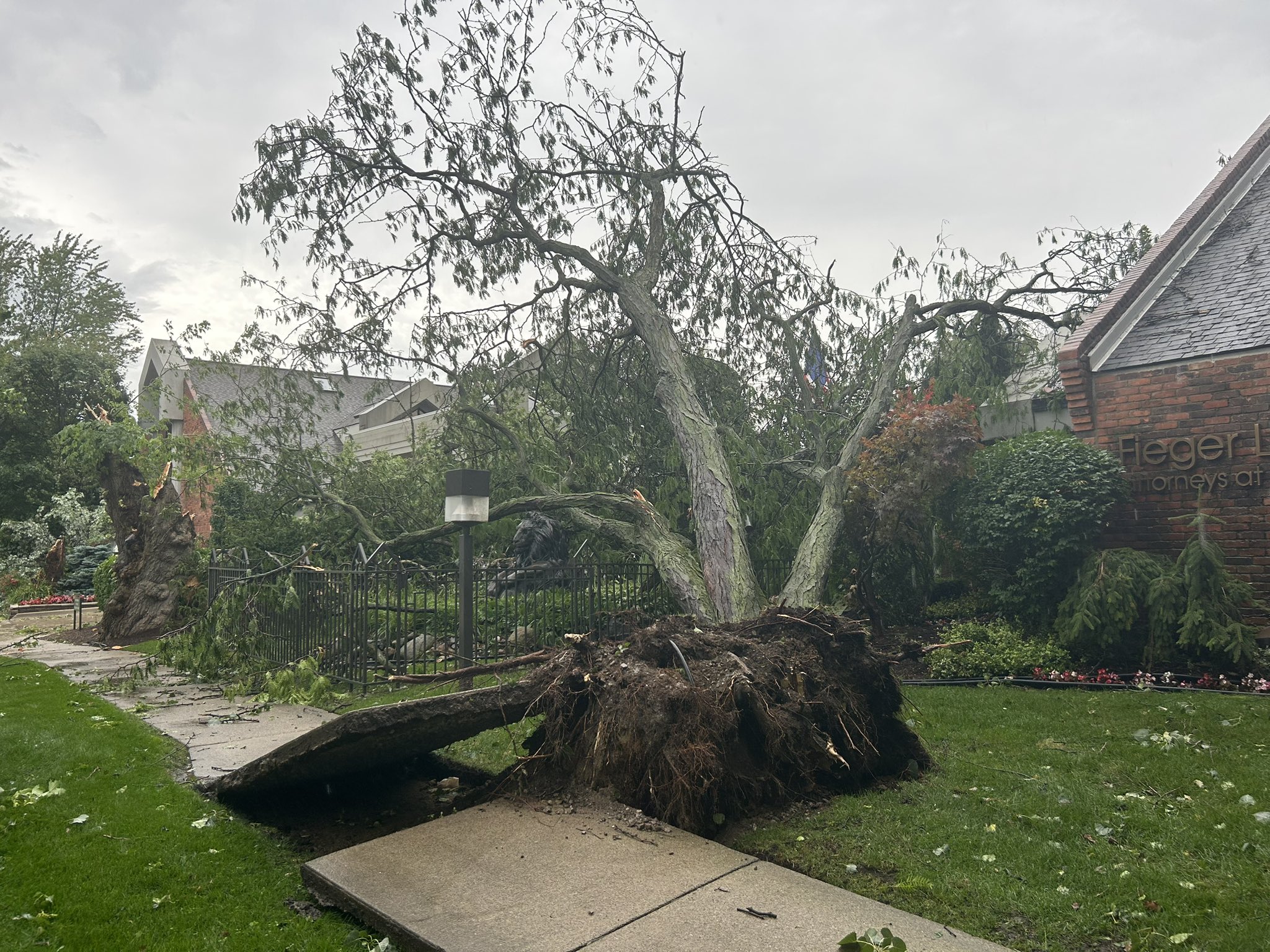
Southfield Credit: Nick Dewhirst |
Southfield Credit: Nick Dewhirst |
Southfield Credit: Ryan Jack Jakubowski |
 |
 |
 |
|
Sumpter Credit: Julie Thompson |
Berkley Credit: NWS Employee |
Monroe Credit: Nick Dewhirst |
Radar
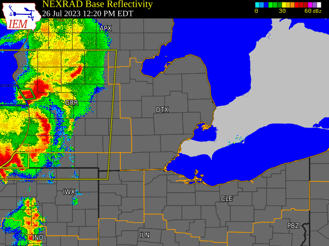
Radar loop courtesy of Iowa Environmental Mesonet (IEM)
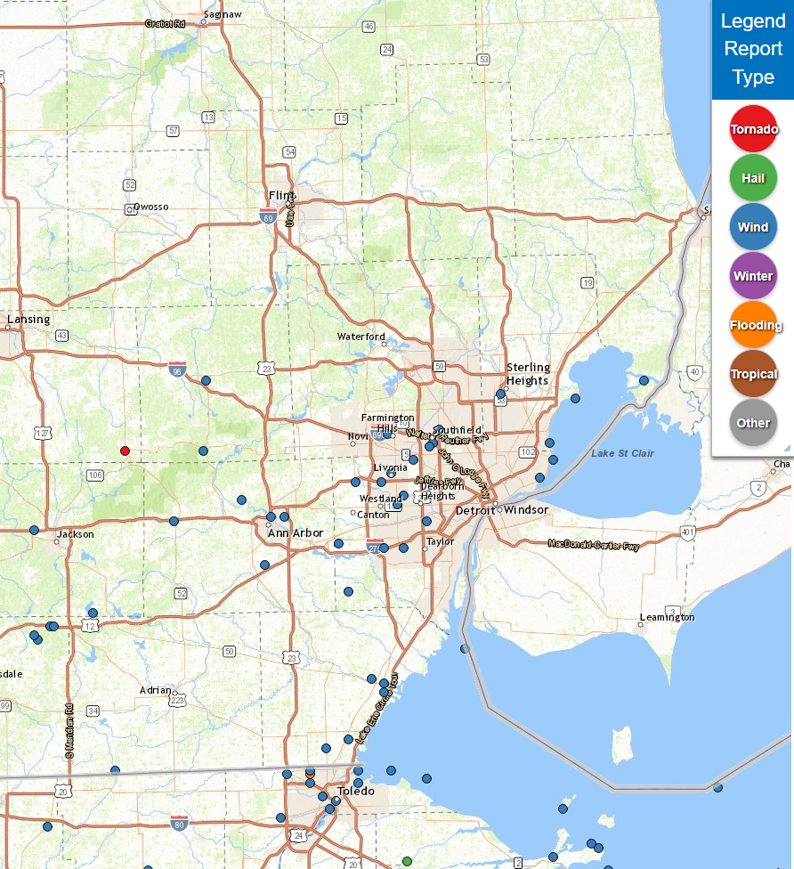
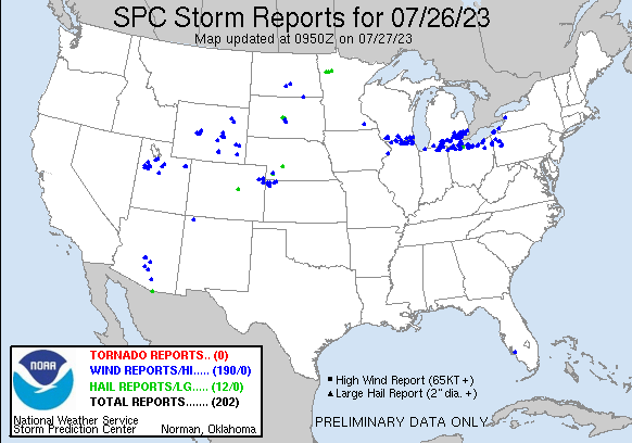
Storm Reports
|
|
|
Map of Local Storm Reports July 26, 2023 |
Severe Weather Local Storm Reports:
Preliminary Local Storm Report...Summary
National Weather Service Detroit/Pontiac MI
1039 PM EDT Wed Jul 26 2023

..TIME...   ...EVENT...      ...CITY LOCATION...     ...LAT.LON...
..DATE...   ....MAG....      ..COUNTY LOCATION..ST.. ...SOURCE....
            ..REMARKS..

0236 PM     Tstm Wnd Dmg     Morenci                 41.72N  84.22W
07/26/2023                   Lenawee            MI   911 Call Center

            Dispatch reports numerous trees and power lines down in
            the Morenci area.

0250 PM     Tstm Wnd Dmg     2 SSW Chelsea           42.29N  84.04W
07/26/2023                   Washtenaw          MI   Emergency Mngr

            Multiple trees down across the area. A couple trees
            blocking roadways.

0259 PM     Tstm Wnd Dmg     1 N Scio                42.34N  83.83W
07/26/2023                   Washtenaw          MI   Emergency Mngr

            EM reports large tree down on a house with an
            individual trapped inside. Time estimated by radar.

0300 PM     Tstm Wnd Dmg     1 NE Saline             42.19N  83.76W
07/26/2023                   Washtenaw          MI   Trained Spotter

            Report of multiple trees and tree limbs down near the
            intersection of Woodland and East Industrial.

0302 PM     Tstm Wnd Dmg     2 N Ann Arbor           42.30N  83.74W
07/26/2023                   Washtenaw          MI   Public

            Report of a large tree limb down on a roof of a house
            near the intersection of Pontiac and Barton.

0303 PM     Tstm Wnd Dmg     2 WSW Dixboro           42.30N  83.70W
07/26/2023                   Washtenaw          MI   Public

            Report of a large tree down near the intersection of
            Prairie Street and Briarcliff Street.

0303 PM     Tstm Wnd Dmg     Pinckney                42.45N  83.95W
07/26/2023                   Livingston         MI   911 Call Center

            Dispatch reports numerous trees and power lines down
            across Pinckney.

0310 PM     Tstm Wnd Dmg     Howell                  42.61N  83.94W
07/26/2023                   Livingston         MI   911 Call Center

            Dispatch reports numerous trees and power lines down
            near Howell.

0313 PM     Tstm Wnd Dmg     1 ENE West Sumpter      42.13N  83.50W
07/26/2023                   Wayne              MI   Public

            Report of trees down near the intersection of Wear and
            Elwell. Time estimated by radar.

0316 PM     Tstm Wnd Gst     2 ENE Romulus           42.23N  83.33W
07/26/2023  M67 mph          Wayne              MI   ASOS

0316 PM     Tstm Wnd Gst     1 SSW Denton            42.24N  83.53W
07/26/2023  M64 mph          Wayne              MI   ASOS

0320 PM     Tstm Wnd Dmg     2 WNW Stark             42.38N  83.40W
07/26/2023                   Wayne              MI   Public

            Report of large trees down near the off ramp of I-96
            and Levan. Time estimated by radar.

0320 PM     Tstm Wnd Dmg     1 W Romulus             42.23N  83.39W
07/26/2023                   Wayne              MI   Public

            Report of large trees down near I-94 and Wayne Road.
            Time estimated by radar.

0320 PM     Tstm Wnd Dmg     Temperance              41.77N  83.57W
07/26/2023                   Monroe             MI   911 Call Center

            Multiple trees down across the city.

0320 PM     Tstm Wnd Dmg     1 W Garden City         42.33N  83.35W
07/26/2023                   Wayne              MI   Public

            Report of large tree limbs down near the intersection
            of Ford and Merriman Road. Time estimated by radar.

0322 PM     Tstm Wnd Dmg     1 S Elm                 42.35N  83.33W
07/26/2023                   Wayne              MI   Public

            Report of a tree limb inside the roof of a home near
            the intersection of Joy and Middlebelt. Time estimated
            by radar.

0322 PM     Tstm Wnd Dmg     Livonia                 42.40N  83.37W
07/26/2023                   Wayne              MI   Public

            Report of large trees uprooted near Levan and 5 Mile.
            Time estimated by radar.

0325 PM     Tstm Wnd Gst     1 NNW Plymouth          42.38N  83.48W
07/26/2023  M61 mph          Wayne              MI   Mesonet

            Measured at M-24 MI US MIDOT Mesonet.

0325 PM     Tstm Wnd Dmg     2 WSW Greenfield Villag 42.29N  83.26W
07/26/2023                   Wayne              MI   Public

            Report of trees down near the intersection of Bennett
            and Oxford. Time estimated by radar.

0326 PM     Tstm Wnd Dmg     2 N Redford             42.43N  83.30W
07/26/2023                   Wayne              MI   Public

            Report of large trees down near the intersection of 7
            Mile and Beech Daly. Time estimated by radar.

0330 PM     Tstm Wnd Dmg     1 SSE Southfield        42.46N  83.25W
07/26/2023                   Oakland            MI   Public

            Report of large trees down near the intersection of 9
            Mile and Beech. Time estimated by radar.

0330 PM     Tstm Wnd Dmg     Erie                    41.79N  83.50W
07/26/2023                   Monroe             MI   911 Call Center

            Multiple trees down across the city.

0331 PM     Tstm Wnd Dmg     1 ESE Southfield        42.47N  83.24W
07/26/2023                   Oakland            MI   Trained Spotter

            Reports of numerous large trees down inlcuding some
            damage to houses and cars near Evergreen and 10 Mile.
            Time estimated based on radar.

0334 PM     Tstm Wnd Dmg     Lathrup Village         42.50N  83.22W
07/26/2023                   Oakland            MI   Trained Spotter

            Report of large trees down near the intersection of 12
            Mile and Southfield Road. Time estimated by radar.

0340 PM     Tstm Wnd Dmg     Monroe                  41.92N  83.39W
07/26/2023                   Monroe             MI   911 Call Center

            Tree down on a house.

0340 PM     Tstm Wnd Dmg     1 S Monroe              41.90N  83.39W
07/26/2023                   Monroe             MI   911 Call Center

            Tree down on a house in Monroe Township.
0345 PM     Tstm Wnd Gst     4 SE Milleville Beach   42.00N  83.14W
07/26/2023  M52 mph          LEZ444             MI   Mesonet

            Measured at Detroit River Light.

0350 PM     Tstm Wnd Dmg     Grosse Pointe           42.39N  82.91W
07/26/2023                   Wayne              MI   Public

            Reports of widespread tree damage in Grosse Pointe.
            Time estimated by radar.

0354 PM     Tstm Wnd Gst     Grosse Pointe Shores    42.43N  82.87W
07/26/2023  M66 mph          LCZ460             MI   Mesonet

            Measured via mesonet at Grosse Pointe Yacht Club.

0356 PM     Tstm Wnd Dmg     Sterling Heights        42.58N  83.03W
07/26/2023                   Macomb             MI   Public

            Large tree down

0356 PM     Tstm Wnd Dmg     Farmington Hills        42.49N  83.38W
07/26/2023                   Oakland            MI   Broadcast Media

            6 inch diameter tree down at the tv station.
0406 PM     Tstm Wnd Gst     1 SSW Saint Clair Haven 42.57N  82.80W
07/26/2023  M42 mph          Macomb             MI   Mesonet

            Measured at Lake St. Clair Metropark.

0420 PM     Tstm Wnd Dmg     1 NW Harsens Island     42.61N  82.59W
07/26/2023                   St. Clair          MI   911 Call Center

            Report of multiple trees down in Harsens Island and
            Clay Township.

0600 PM     Rain             7 SW Bad Axe            43.74N  83.09W
07/26/2023  M1.32 inch       Huron              MI   Trained Spotter

            Storm total rainfall accumulation of 1.32 inches.
1125 PM     Rain             2 ENE Ypsilanti         42.26N  83.58W
07/26/2023  M1.10 inch       Washtenaw          MI   Trained Spotter

            8 hour rainfall total.

1139 PM     Rain             1 NNE Roseville         42.51N  82.93W
07/26/2023  M1.05 inch       Macomb             MI   Public

            8 hour rainfall total.

&&

 |
|
National Storm Reports for July 26, 2023 |
Environment
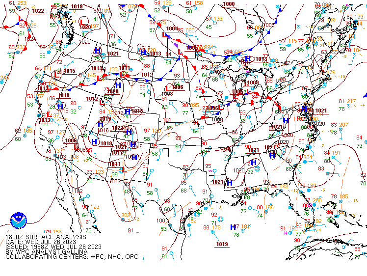
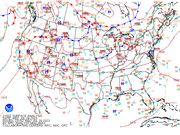
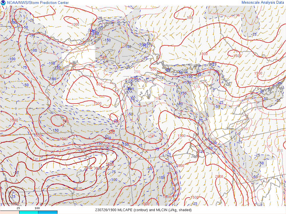
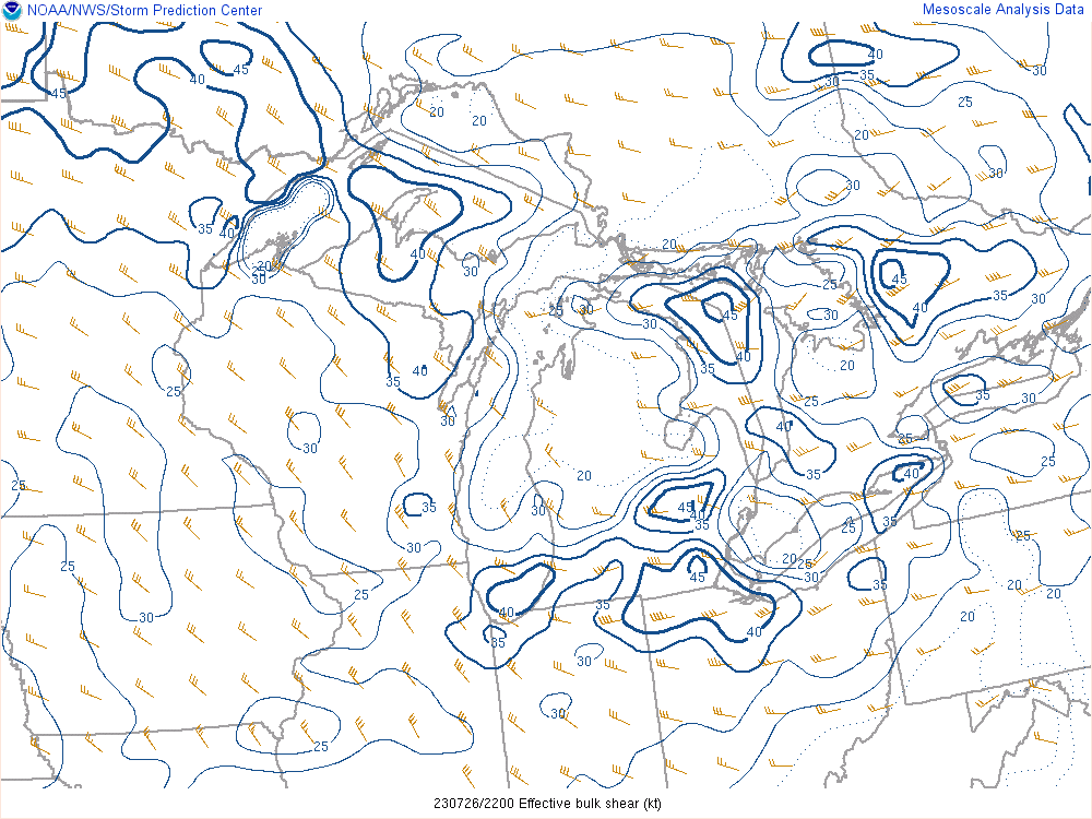
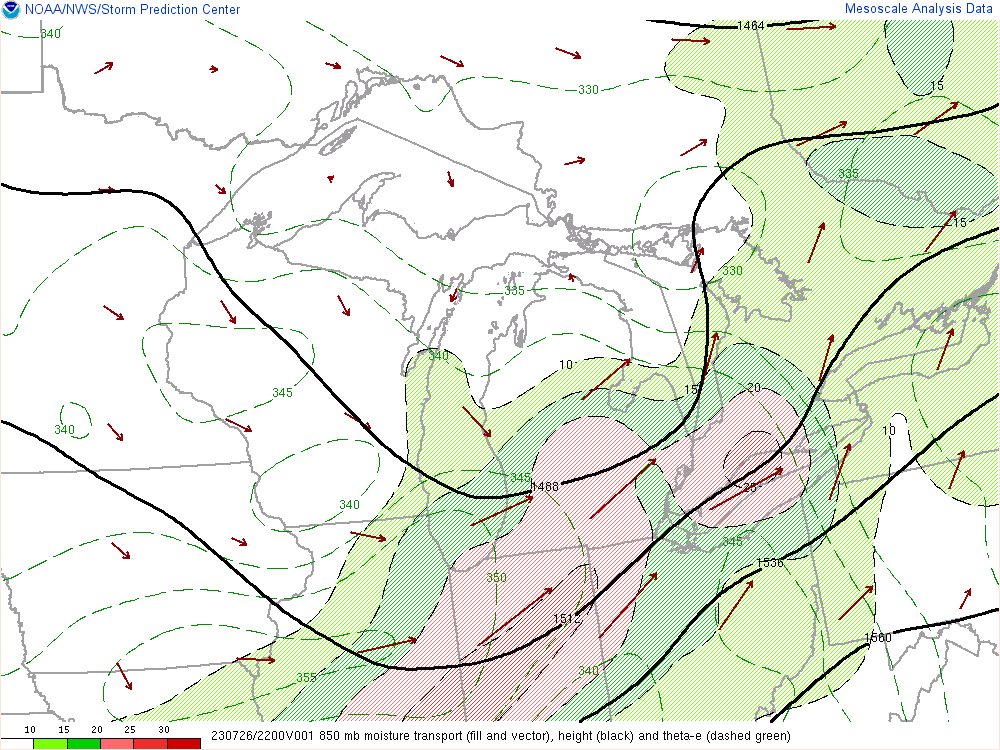
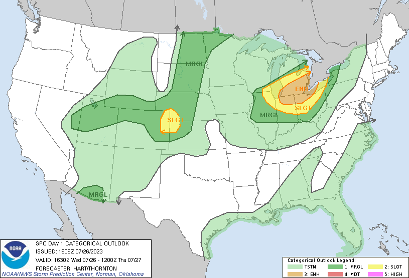
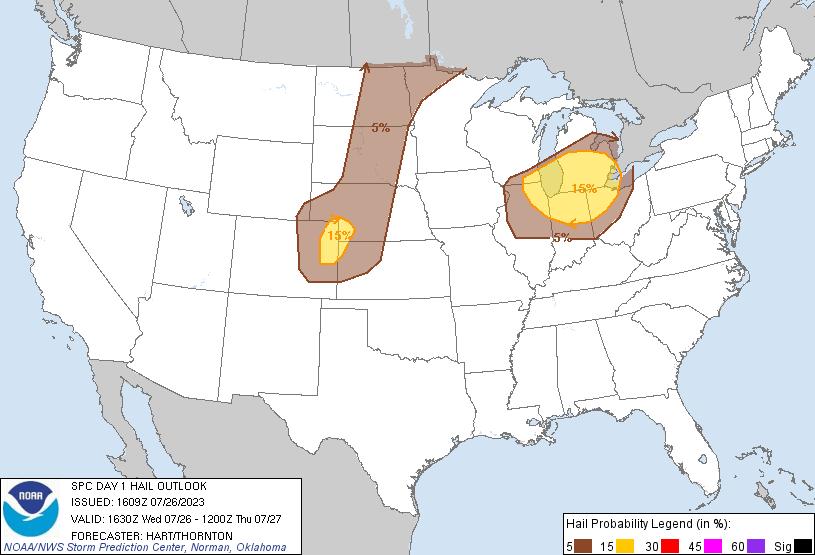
A strong and compact mid level system tracked across Lower MI on Wednesday afternoon providing the upper level support for multiple rounds of strong to severe thunderstorms. At the same time a surface low would lift through southern/central MI providing surface forcing with the warm front lifting into the area in the early afternoon and a cold front later in the evening. Nearly zonal flow was in place across the region heading into Wednesday with the heat dome ridge over the central Plains trying to push into the area. This put us on the edge of the strong instability gradient that fed the nocturnal MCSs to our west that would later make their way into southwest lower MI Wednesday morning. These remnant systems were able to feed off the instability (around 1000-1500 J/kg of MLCAPE by 18Z), and shear (effective shear around 40 knots) while riding the rich theta e gradient pushing into the area. The atmosphere was very moist with surface dewpoints around 70 degrees and PWATs over 1.5” which lead to efficient rainfall rates with stronger storms. The strong warm advection raised the freezing level to around 14kft which made hail a lesser threat but strong mid level lapse rates and dry mid levels made for very strong wind gusts. The DTX 18Z sounding showed this potential also with 1214 J/kg of DCAPE. The first round of storms mainly affected locations south of M59 with a line of storms forming a bowing segment which ended up producing winds of 60-80 mph at times from the Ann Arbor area through southern Oakland County and northern Wayne County and later through the Grosse Pointe area. The cold front lagged behind and with strong advection into the warm sector was able to develop another round of strong storms. Southeast MI was worked over enough that storms came through sub-severe, but severe storms were able to develop to our west which then dove southeast into the better instability.
 |
 |
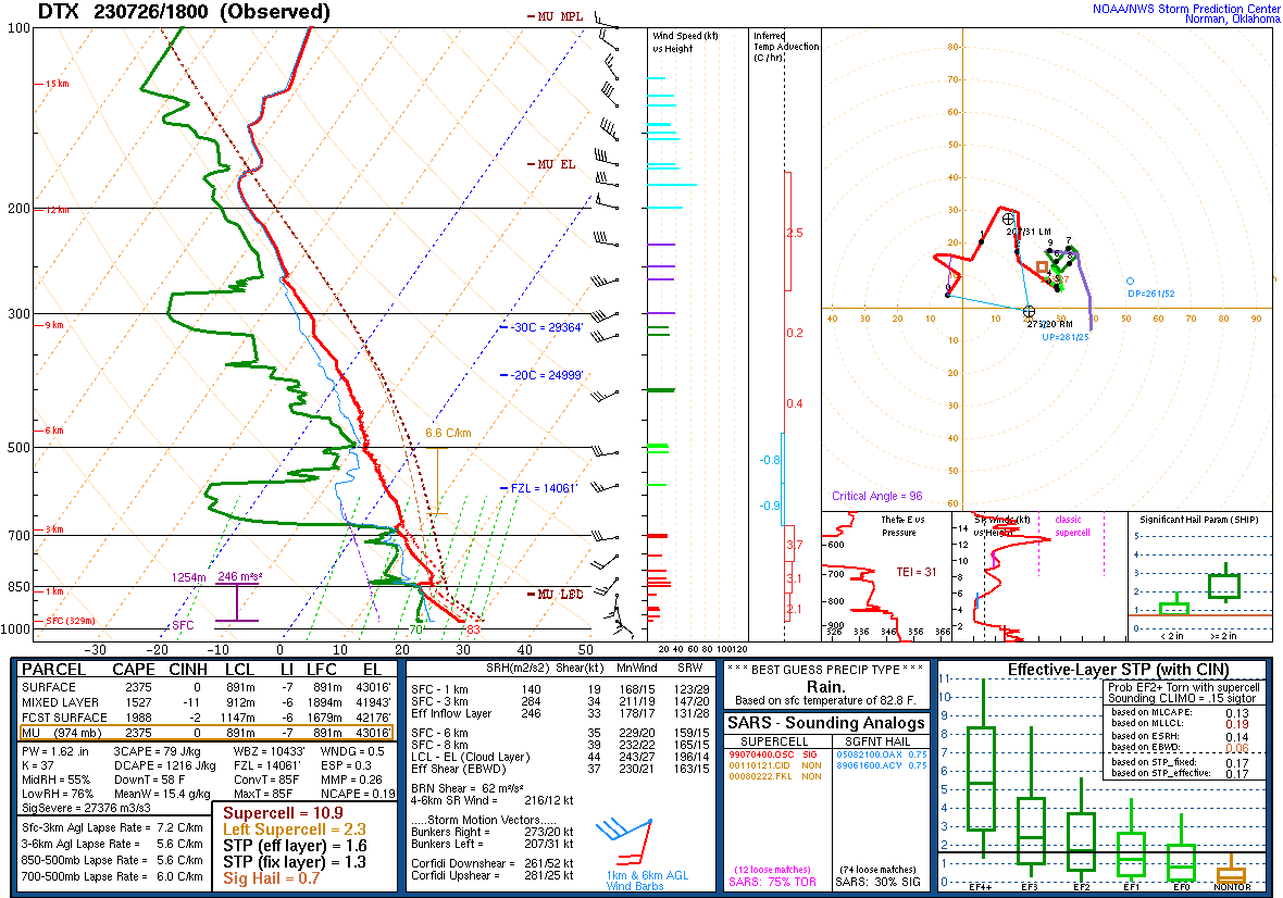 |
| Figure 1: WPC Surface Analysis, valid 1800 UTC 26 Jul 2023 | Figure 2: WPC Surface Analysis, valid 2100 UTC 26 Jul 2023 | Figure 3: DTX Sounding, valid 1800 UTC 26 Jul 2023 |
 |
 |
 |
| Figure 4: Mixed-Layer CAPE, CIN, and EBS 1900 UTC 26 Jul 2023 | Figure 5: Effective Wind Shear, valid 2200 UTC 26 Jul 2023 | Figure 6: 700-500 mb Lapse Rates valid 2200 UTC 26 Jul 2023 |
 |
 |
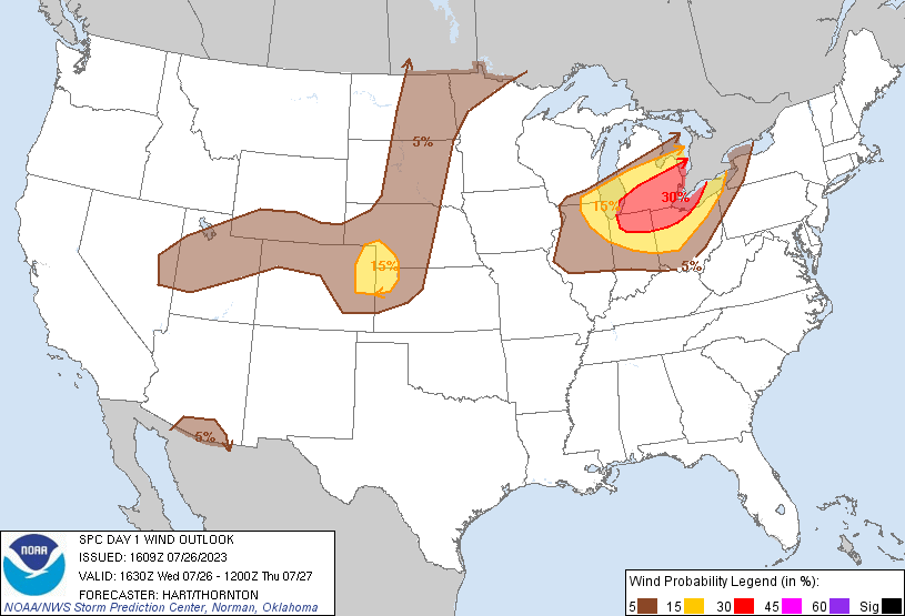 |
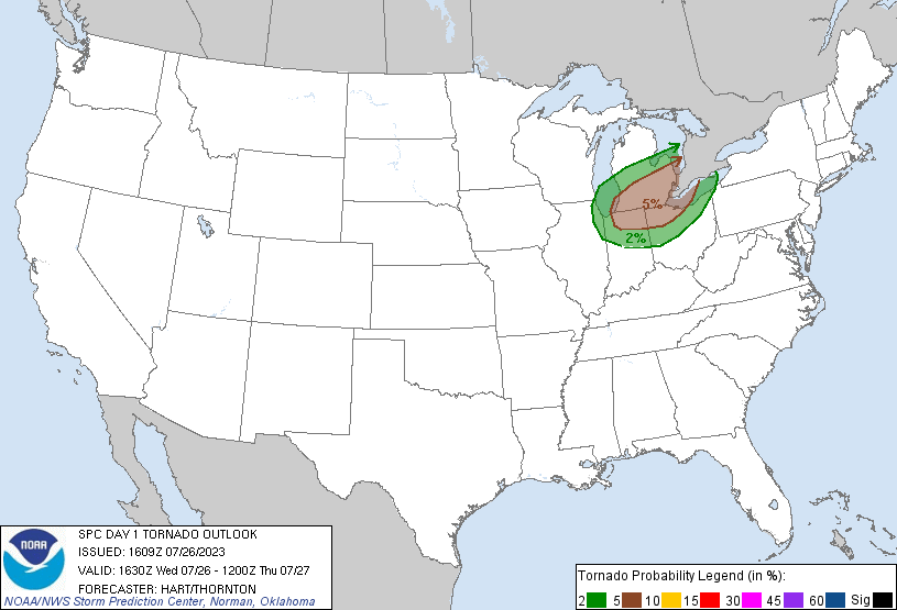
| Figure 7: 850 mb Moisture Transport valid, 22 UTC 26 Jul 2023 | Figure 8: SPC Day 1 Severe Weather Outlook, valid 1630 UTC 26 Jul 2023 | Figure 9: SPC Day 1 Probabilistic Wind Outlook, valid 1630 UTC 26 Jul 2023 |
 |
 |
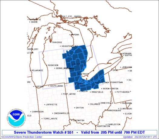 |
| Figure 10: SPC Day 1 Probabilistic Hail Outlook, valid 1630 UTC 26 Jul 2023 | Figure 11: SPC Day 1 Probabilistic Tornado Outlook, valid 1630 UTC 26 Jul 2023 | Figure 12: Severe Thunderstorm Watch 551, valid 16 July 2023 |
 |
Media use of NWS Web News Stories is encouraged! Please acknowledge the NWS as the source of any news information accessed from this site. |
|