| Overview | Radar |
March came in like a lion never seemed more appropriate than for this winter storm that affected Southeast Michigan on the first day of March. The weather so far for the winter season has been quite a roller coaster with winter storms and above normal temperatures. The two days leading up to this event featured above normal temperatures in the 50s and 60s as southerly winds brought in warmer air ahead of the low pressure system. This low pressure system took shape out in the southern plains and quickly deepened as it moved northeast across the Ohio Valley. This system brought a mixed bag of precipitation to the area including rain and freezing rain to locations around the Detroit area and points south while areas north saw all snow. Areas that saw all snow, especially across the Saginaw Valley and Thumb areas had upwards of a foot of snow in some locations. The Detroit and Downriver areas where a mixture of precipitation types fell, only saw a couple of inches of snow. As the low pressure pushed northeast, warmer air was able to work in for a longer period of this area and thus cutting into the total snowfall accumulations. Now the question is will March go out like a lamb. Only time will tell!
Back to top
Radar loop
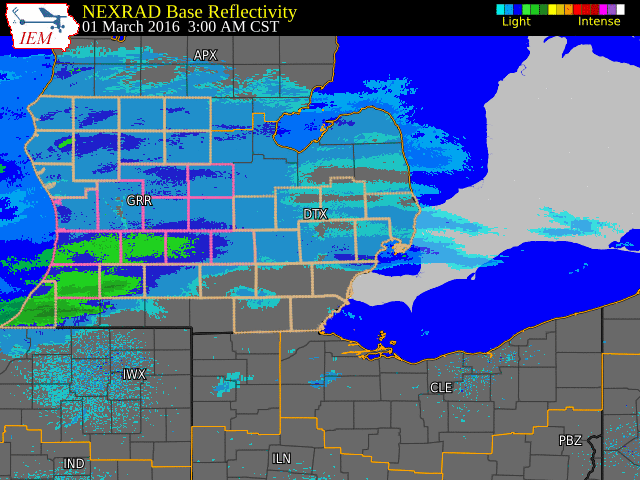 |
| Radar loop courtesy of Iowa Environmental Mesonet (IEM) |

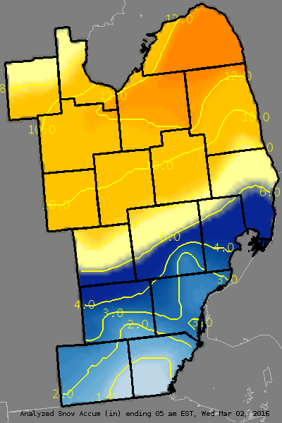
PUBLIC INFORMATION STATEMENT...STORM TOTALS
NATIONAL WEATHER SERVICE DETROIT/PONTIAC MI
105 PM EST WED MAR 2 2016


STORM TOTAL SNOW REPORTS

LOCATION                  SNOWFALL     DURATION
                          (INCHES)      (HOURS)        LAT       LON

...GENESEE COUNTY...
   FENTON                  E   5.5           15     42.80N    83.71W
   LINDEN                  M   6.7           30     42.82N    83.78W
   GOODRICH                M   6.9           28     42.92N    83.51W
   LINDEN                  M   7.4           18     42.82N    83.78W
   5 N DAVISON             M   8.0           15     43.10N    83.52W
   DAVISON                 M   9.5           16     43.03N    83.52W
   FLINT                   M   9.5           24     43.02N    83.69W
   SWARTZ CREEK            M  10.0           19     42.96N    83.83W
   4 N BURTON              M  10.2           27     43.05N    83.62W
   2 S CLIO                M  10.5           28     43.15N    83.74W

...HURON COUNTY...
   BAD AXE                 M   9.0           24     43.80N    83.00W
   FILION                  M   9.1           23     43.90N    83.00W
   BAD AXE                 M  13.0           17     43.80N    83.00W
   PIGEON                  M  13.0           24     43.83N    83.27W
   HARBOR BEACH            M  14.0           20     43.85N    82.65W

...LAPEER COUNTY...
   5 ESE DAVISON           M   7.5           28     43.02N    83.43W
   4 W NORTH BRANCH        M   9.0           28     43.22N    83.26W

...LENAWEE COUNTY...
   MORENCI                 M   1.6           30     41.72N    84.22W
   2 WNW TIPTON            M   2.3           30     42.03N    84.10W

...LIVINGSTON COUNTY...
   HARTLAND                M   5.0           14     42.66N    83.75W
   1 NE HOWELL             M   5.5           18     42.62N    83.92W
   HOWELL                  M   6.3         22.5     42.61N    83.94W

...MACOMB COUNTY...
   SHELBY TOWNSHIP         M   3.0           13     42.67N    83.03W
   ROSEVILLE               M   4.0           16     42.51N    82.94W
   4 ENE TROY              M   4.5            M     42.59N    83.07W
   RICHMOND                M   5.2           24     42.81N    82.75W
   CHESTERFIELD TOWNSHIP   M   5.5           18     42.68N    82.82W
   EASTPOINTE              M   5.5           19     42.47N    82.96W
   NEW BALTIMORE           M   5.7           24     42.68N    82.74W
   ARMADA                  M   6.0           16     42.84N    82.88W

...MIDLAND COUNTY...
   OIL CITY                M   5.6           24     43.61N    84.59W
   MIDLAND                 M   7.5           18     43.62N    84.23W
   2 SSW MIDLAND           M   8.5            M     43.60N    84.24W

...MONROE COUNTY...
   4 SSE NEWPORT           M   2.1           30     41.95N    83.28W

...OAKLAND COUNTY...
   FARMINGTON              M   1.9           30     42.46N    83.38W
   BLOOMFIELD HILLS        M   2.5           24     42.58N    83.25W
   2 NNE WIXOM             M   3.2           18     42.55N    83.52W
   2 NNE WIXOM             M   3.6           19     42.55N    83.52W
   2 S LAKEVILLE           M   4.6           30     42.79N    83.15W
   CLARKSTON               M   5.2           28     42.74N    83.42W
   LAKE ORION              M   5.2           28     42.78N    83.24W
   4 E WHITE LAKE          M   6.3           30     42.65N    83.43W

...SAGINAW COUNTY...
   5 S MERRILL             M   8.0           15     43.34N    84.34W
   HEMLOCK                 M   9.0           27     43.42N    84.23W
   OAKLEY                  M   9.0           13     43.14N    84.17W
   2 N SAGINAW             M   9.9         15.5     43.45N    83.95W
   CHESANING               M  10.0           27     43.18N    84.12W
   5 W SAGINAW             M  10.7           24     43.42N    84.05W
   2 NW SAGINAW            M  11.0           17     43.44N    83.98W
   SAGINAW                 M  12.0           18     43.42N    83.95W
   BRIDGEPORT              M  12.1         15.5     43.38N    83.88W
   FRANKENMUTH             M  12.1           27     43.33N    83.74W
   BURT                    M  12.5           18     43.24N    83.91W

...SANILAC COUNTY...
   LEXINGTON               M   7.0           27     43.27N    82.53W
   2 W PECK                M   9.5           16     43.26N    82.86W
   SANDUSKY                M  10.0           27     43.42N    82.83W
   MARLETTE                M  10.3           30     43.33N    83.08W
   2 W PECK                M  12.0           22     43.26N    82.86W

...SHIAWASSEE COUNTY...
   DURAND                  M  10.0           27     42.91N    83.99W
   3 SW PERRY              M  10.4           18     42.79N    84.27W
   OWOSSO                  M  10.6           27     43.00N    84.18W

...ST. CLAIR COUNTY...
   PORT HURON              M   4.3           17     42.99N    82.43W
   YALE                    M   4.8           27     43.13N    82.80W

...TUSCOLA COUNTY...
   CASS CITY               M  11.0           24     43.60N    83.18W
   VASSAR                  M  11.0           24     43.37N    83.58W

...WASHTENAW COUNTY...
   YPSILANTI               M   2.0           18     42.24N    83.62W
   MILAN                   M   2.5           30     42.09N    83.68W
   SE ANN ARBOR            M   3.4           30     42.28N    83.73W
   MANCHESTER              M   3.5           30     42.15N    84.04W
   ANN ARBOR               M   3.8           24     42.28N    83.73W

...WAYNE COUNTY...
   GARDEN CITY             M   2.6           24     42.33N    83.33W
   LIVONIA                 M   3.2           30     42.40N    83.37W
   ROMULUS                 M   3.3           24     42.22N    83.37W
   WYANDOTTE               M   3.3           30     42.21N    83.16W


M = MEASURED
E = ESTIMATED

$$
Back to top

