Detroit/Pontiac, MI
Weather Forecast Office
Overview
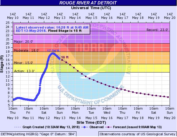
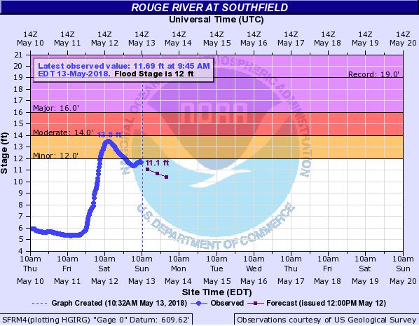
A frontal boundary that stalled south of Michigan allowed repeated rounds of rainfall to move across the region from May 11 to early May 13, 2018. The heaviest axis of rain fell across the I-696 corridor with locations seeing anywhere between 1.5" - 3.5" of accumulation. Impacts included several road closures across Oakland County down into Wayne County due to localized flooding. Additionally, the Rouge River in Southfield/Detroit and Clinton River near Clinton Township quickly reached minor flood stage, impacting communities and roadways along the rivers.
Flooding
Hydrographs
 |
 |
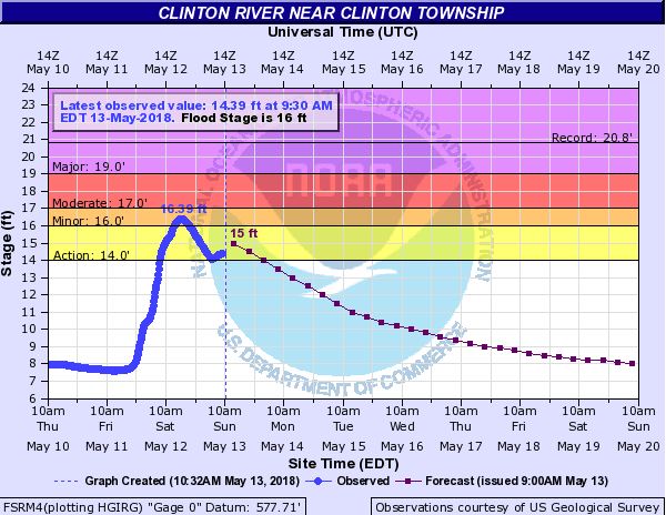 |
| Rouge River at Detroit | Rouge River at Southfield | Clinton River near Clinton Twp |
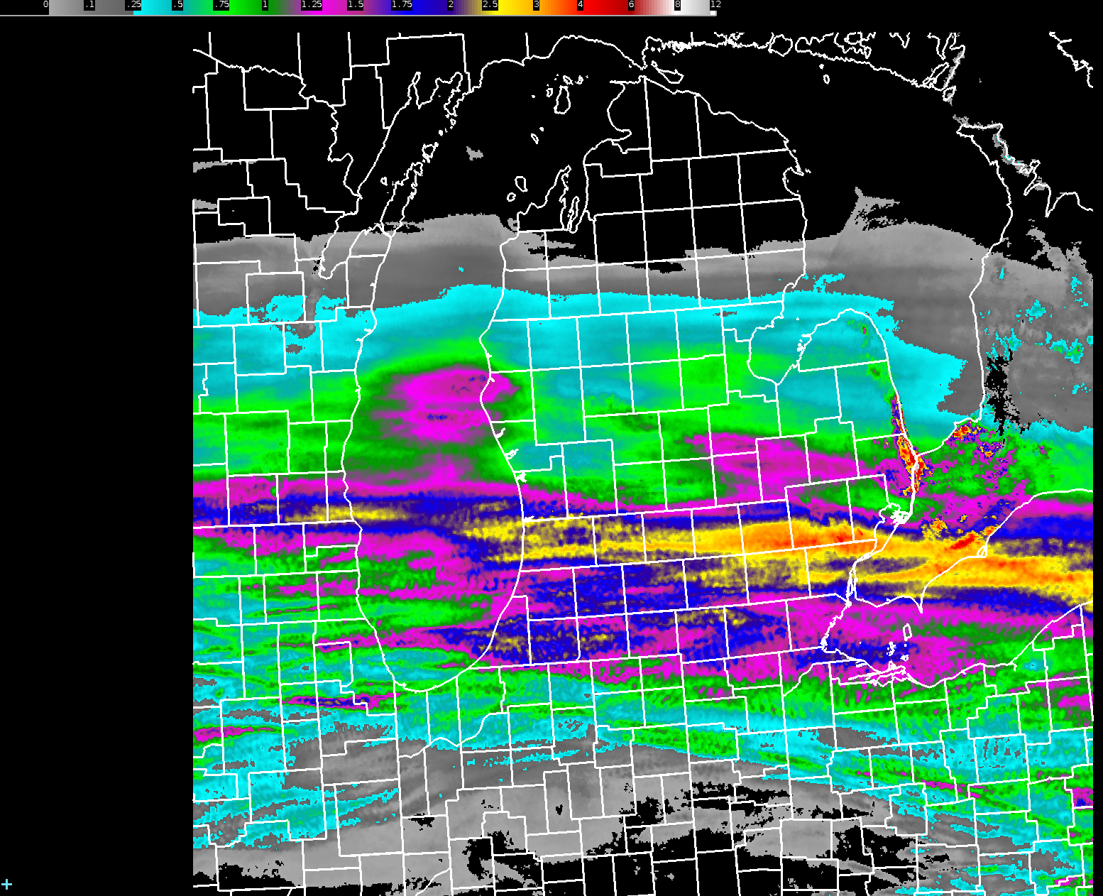
Radar Derived Precipitation Estimates
 |
|
48 Hour Radar Derived Precipitation Estimates * Note that NWS DTX's radar had an unexpected outage from May 12, 131 PM - 635 PM, thus rainfall estimates were not accumulated during this time. Additionally, unusually high estimates located along the Lake Huron shoreline from St. Clair County up to Sanilac County were artificially inflated due to ground clutter, and do not represent rainfall estimates across that area. * |
Radar
.gif) |
.gif) |
.gif) |
|
Doppler Radar Reflectivity |
Doppler Radar Reflectivity *Note that NWS DTX's radar had an unexpected outage from May 12, 131 PM - 635 PM, thus reflectivity may not be accurately represented around SE MI during this time.* |
Doppler Radar Reflectivity *Note that NWS DTX's radar had an unexpected outage from May 12, 131 PM - 635 PM, thus reflectivity may not be accurately represented around SE MI during this time.* |
Rain Reports
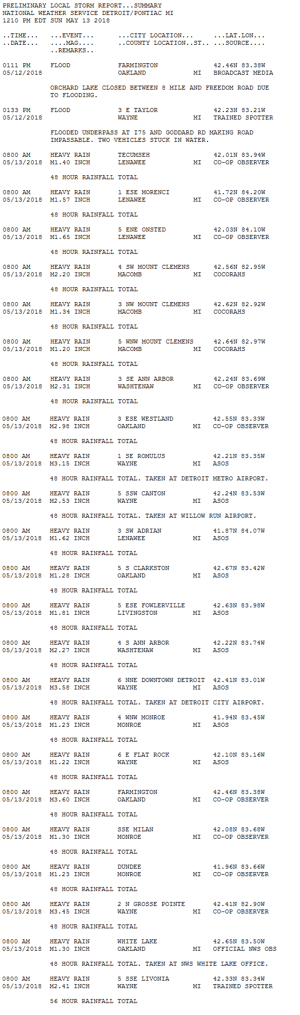 |
 |
Media use of NWS Web News Stories is encouraged! Please acknowledge the NWS as the source of any news information accessed from this site. |
|
Weather Forecasts
Fire Weather
Snowfall Forecast
Marine Forecast
Beach Forecast
Aviation
Digital Forecast Graphics
Current Weather Conditions
Local Observations
Today's Weather History
Observed Snowfall
Regional Radar Mosaic
Past Weather Records
Climate records by month
Additional Daily Climate Data
Top 20 Lists
Breakdown by Decade
Largest Snowstorms
Season Snowfall Maps
Year To Date Plots
Severe Weather
Daily Plots
Annual Plots
Event Summaries
US Dept of Commerce
National Oceanic and Atmospheric Administration
National Weather Service
Detroit/Pontiac, MI
9200 White Lake Road
White Lake, MI 48386
248-620-9804
Comments? Questions? Please Contact Us.

