We are a little more than two-thirds of the way through meteorological summer (defined as June, July, and August), so let's take a look at how the climate has shaped up so far over southeastern Michigan.
Let's take a look at two of our climate sites, Detroit Metropolitan Airport (DTW) and Saginaw Tri-Cities Airport (MBS). The following table shows that the average temperature at both DTW and MBS have been near normal for June and July.
| June | July | June & July | Departure from Normal | |
| DTW | 69.7 | 74.0 | 71.9 | +0.3 |
| MBS | 67.6 | 71.7 | 69.7 | +0.6 |
It may come as a surprise to some that this summer's temperatures have been near normal so far, especially since Detroit didn't hit 90 until July 15, and with last summer's heat fresh in many minds. A daily breakdown of the temperatures for Detroit (see graphs below) shows that June began on a relatively cool note, before temperatures rebounded to near normal levels. The end of June saw 7 straight days with both the high and low temperature above normal (June 21-27). July came in on a cool note, with a high temperature of only 69 degrees on the 1st. The period of July 4-10 was noteworthy, as each day in this stretch had low temperatures well above normal, though high temperatures were only above normal 2 days. We saw our most impressive stretch of warm weather during the week of July 14-21. Heat Advisories and Excessive Heat Warnings were in effect during portions of this period, as warm and humid air caused heat indices to approach 105 on some afternoons. Detroit saw 5 straight days with highs in the 90s during this stretch, and 6 straight days with lows in the 70s. An abrupt change occurred for the end of the month, as high temperatures did not reach 80 from July 24 through the end of the month. Flint Bishop Airport set a daily record low minimum temperature on the 25th, with a low of 47. This came just 5 days after setting its record high minimum temperature on the 20th, with a low of 78!
Click images to enlarge
Another interesting aspect of the temperatures so far is the breakdown of above/below normal daily highs and lows, as summarized in the table below:
| DTW | MBS | |
| High Above Normal | 23 | 25 |
| High Below Normal | 34 | 35 |
| Low Above Normal | 35 | 32 |
| Low Below Normal | 19 | 26 |
At both DTW and MBS, there have been more days with high temperatures below normal than above normal, but there have also been more days with low temperatures above normal than below normal. This corroborates with the fact that the average temperature has been near normal so far this summer.
The table below shows the precipitation amounts for DTW, MBS and Flint Bishop Airport (FNT):
| June | July | June+July | Departure from normal | |
| DTW | 6.01 | 4.14 | 10.15 | +3.26 |
| FNT | 4.51 | 1.74 | 6.25 | -0.14 |
| MBS | 2.54 | 1.08 | 3.62 | -1.94 |
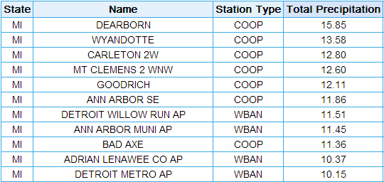
As we can see, DTW has had a wetter than normal summer so far, while MBS has been drier than normal, and FNT near normal. The 1.08" that fell at MBS in July ranks as its 13th driest July. Meanwhile, the 6.01" that fell at DTW in June ranks as its 9th wettest June, while June and July combined rank as its 13th wettest. Several other stations saw a very wet June and July, mainly from the Detroit Metro area to the Ohio border. Here are several of the "winners," including data from COOP stations:
Total precipitation, June+July:

To put the 15.85" recorded at Dearborn in perspective, that value would have ranked as the wettest June+July of all time at DTW, and even would have ranked as the 4th wettest whole summer at DTW! This table also shows how precipitation can vary dramatically over a short distance, especially during the summer months when localized heavy rain is possible during thunderstorms.
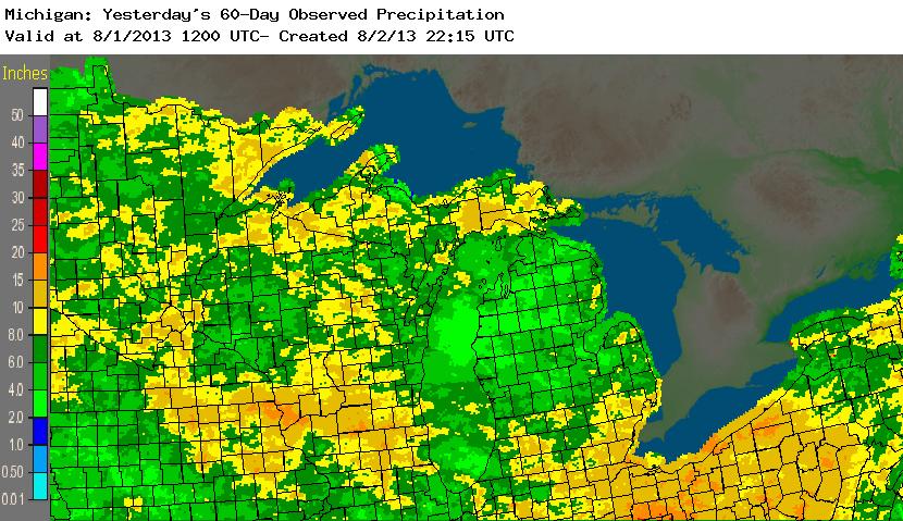
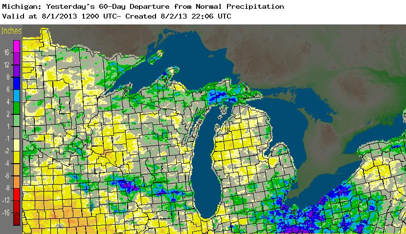
The following images show a spatial estimate of June and July precipitation, using rain gauge, radar, and satellite data:


Many areas from Livingston/Oakland/Macomb counties southward saw significantly above normal rainfall, while areas near the Saginaw Valley were actually below normal.
We will continue to monitor the climate for August, and update this story at the end of summer. So far the cool weather from the end of July has persisted into early August and shows no signs of abating, at least for now!