Detroit/Pontiac, MI
Weather Forecast Office
| Overview | Radar |
A quick moving clipper system moved across the Great Lakes region Thursday into Friday, blanketing Southeast Michigan with snow. Snowfall accumulations were generally around 2 to 3 inches over most locations. Majority of the snow fell in a 6 hour period from around 4 pm to 10 pm Thursday, with a few extra tenths of new snow falling during the early morning hours on Friday. Gusty winds associated with this system brought blowing and drifting snow, causing hazardous driving conditions Thursday evening into Friday morning.
Back to top
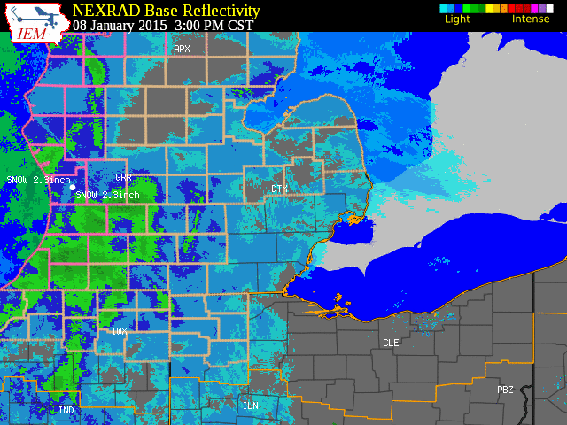 |
| Radar loop courtesy of Iowa Environmental Mesonet (IEM). A winter weather advisory was in effect for this event. |
|
|
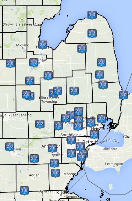
| Image courtesy of Iowa Environmental Mesonet (IEM). Local Storm Reports (LSR) are also shown plotted on the map. |
| Text Summary of Local Storm Reports (LSRs) |
Back to top
Weather Forecasts
Fire Weather
Snowfall Forecast
Marine Forecast
Beach Forecast
Aviation
Digital Forecast Graphics
Current Weather Conditions
Local Observations
Today's Weather History
Observed Snowfall
Regional Radar Mosaic
Past Weather Records
Climate records by month
Additional Daily Climate Data
Top 20 Lists
Breakdown by Decade
Largest Snowstorms
Season Snowfall Maps
Year To Date Plots
Severe Weather
Daily Plots
Annual Plots
Event Summaries
US Dept of Commerce
National Oceanic and Atmospheric Administration
National Weather Service
Detroit/Pontiac, MI
9200 White Lake Road
White Lake, MI 48386
248-620-9804
Comments? Questions? Please Contact Us.