It was a wet and windy Halloween across southeast Michigan. Warm, moist air was drawn northward ahead of an approaching upper-level trough on Oct. 30. A warm front pushed through the region late in the evening, sparking a round of showers and a few embedded thunderstorms. Rain continued for much of the day on Halloween, while temperatures were quite mild for late October, with temperatures reaching the low to mid-60s in most locations. Breezy southerly winds occurred for much of the day, with gusts topping out in the 30-40 mph range.
As the upper-level trough drew nearer, it prompted a surface low pressure system to rapidly intensify as it moved from eastern Wisconsin to north of Lake Huron by the early morning hours of November 1:

Loop of infrared satellite and mean sea level pressure from 3:30 pm 31 Oct through 10:30 am 1 Nov
This low dragged a cold front through southeast Michigan around midnight. Precipitation waned in the wake of the front, but winds increased and turned to west-southwesterly. High Wind Warnings were in effect for areas north of I-69, with Wind Advisories to the south. Winds gusted to 40-50 mph during the overnight hours, resulting in a few power outages:
PUBLIC INFORMATION STATEMENT
NATIONAL WEATHER SERVICE DETROIT/PONTIAC MI
700 AM EDT FRI NOV 1 2013
THE FOLLOWING ARE SOME PEAK WIND GUSTS REPORTED TO THE NATIONAL
WEATHER SERVICE TODAY...AS OF 700 AM...
PONTIAC 48 MPH 213 AM...
PORT HOPE 48 MPH 439 AM...
BAD AXE 46 MPH 435 AM...
YPSILANTI 45 MPH 410 AM...
SAGINAW 45 MPH 319 AM...
HARRY BROWNE 44 MPH 414 AM...
FLINT 43 MPH 448 AM...
LAPEER 43 MPH 414 AM...
DETROIT METRO AIRPORT 41 MPH 321 AM...
ANN ARBOR 41 MPH 348 AM...
OWOSSO 41 MPH 415 AM...
HOWELL 41 MPH 414 AM...
MONROE 41 MPH 455 AM...
DETROIT CITY AIRPORT 40 MPH 240 AM...
CARO 39 MPH 335 AM...
ADRIAN 37 MPH 403 AM...
TROY 37 MPH 434 AM...
LAMBERTVILLE 35 MPH 555 AM...
GROSSE ILE 33 MPH 554 AM...
PORT HURON 31 MPH 436 AM...
$$
Storm rainfall totals from late on October 30 through early on November 1 generally ranged from 1 to 2.25 inches, with the heaviest amounts over Lenawee, Washtenaw, and Wayne counties. Detroit, Flint, and Saginaw all saw their wettest Halloween of all time. The long duration of the rainfall, combined with relatively dry conditions prior to the rainfall, minimized any flooding concerns.
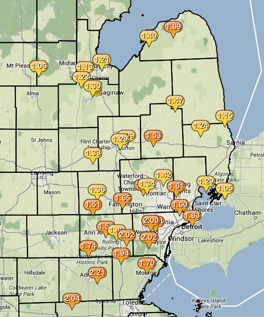
Storm total rainfall from late Ocotober 30 to early November 1. Image courtesy of Iowa Environmental Mesonet (IEM).
NOUS43 KDTX 011357
PNSDTX
MIZ047>049-053>055-060>063-068>070-075-076-082-083-011530-
PUBLIC INFORMATION STATEMENT
NATIONAL WEATHER SERVICE DETROIT/PONTIAC MI
957 AM EDT FRI NOV 1 2013
HEAVY RAIN REPORTS
LOCATION PRECIP DURATION
(INCHES) (HOURS) LAT LON
...BAY COUNTY...
AUBURN M 1.13 48 43.60N 84.08W
5 N BAY CITY M 1.21 48 43.66N 83.89W
...GENESEE COUNTY...
FLINT M 1.29 48 43.02N 83.69W
4 N BURTON M 1.39 48 43.05N 83.62W
...HURON COUNTY...
BAY PORT M 1.40 48 43.85N 83.37W
5 WNW FILION M 1.69 48 43.92N 83.10W
...LAPEER COUNTY...
LAPEER M 1.53 48 43.05N 83.32W
...LENAWEE COUNTY...
MORENCI M 2.04 48 41.72N 84.22W
6 ENE ADRIAN M 2.21 48 41.93N 83.94W
...LIVINGSTON COUNTY...
HOWELL M 1.36 48 42.61N 83.94W
3 NW PINCKNEY M 1.51 48 42.49N 83.99W
...MACOMB COUNTY...
NEW BALTIMORE M 1.29 48 42.68N 82.74W
3 SW SHELBY TOWNSHIP M 1.61 48 42.64N 83.07W
...MIDLAND COUNTY...
OIL CITY M 1.06 48 43.61N 84.59W
...MONROE COUNTY...
3 S CARLETON M 1.70 48 42.01N 83.39W
...OAKLAND COUNTY...
WATERFORD M 1.34 48 42.66N 83.39W
4 SSE LAKE ORION M 1.42 48 42.73N 83.21W
4 E WHITE LAKE M 1.50 48 42.65N 83.43W
4 SW MILFORD M 1.65 48 42.54N 83.66W
...SAGINAW COUNTY...
FREELAND M 1.23 48 43.52N 84.12W
3 NW SAGINAW M 1.30 48 43.45N 83.99W
...SANILAC COUNTY...
4 S LEXINGTON M 1.15 48 43.21N 82.53W
MARLETTE M 1.47 48 43.33N 83.08W
...SHIAWASSEE COUNTY...
DURAND M 1.33 48 42.91N 83.99W
...ST. CLAIR COUNTY...
ALGONAC M 1.05 48 42.62N 82.53W
YALE M 1.24 48 43.13N 82.80W
...WASHTENAW COUNTY...
ANN ARBOR M 1.49 48 42.28N 83.73W
2 SE DEXTER M 1.56 48 42.31N 83.85W
MANCHESTER M 1.74 48 42.15N 84.04W
MILAN M 1.94 48 42.09N 83.68W
YPSILANTI M 2.02 48 42.24N 83.62W
...WAYNE COUNTY...
GROSSE POINTE FARMS M 1.63 48 42.40N 82.89W
2 NW DEARBORN HEIGHTS M 1.64 48 42.35N 83.30W
3 SSE LIVONIA M 2.00 48 42.36N 83.35W
ROMULUS M 2.02 48 42.22N 83.37W
M = MEASURED
E = ESTIMATED
$$

