Overview
|
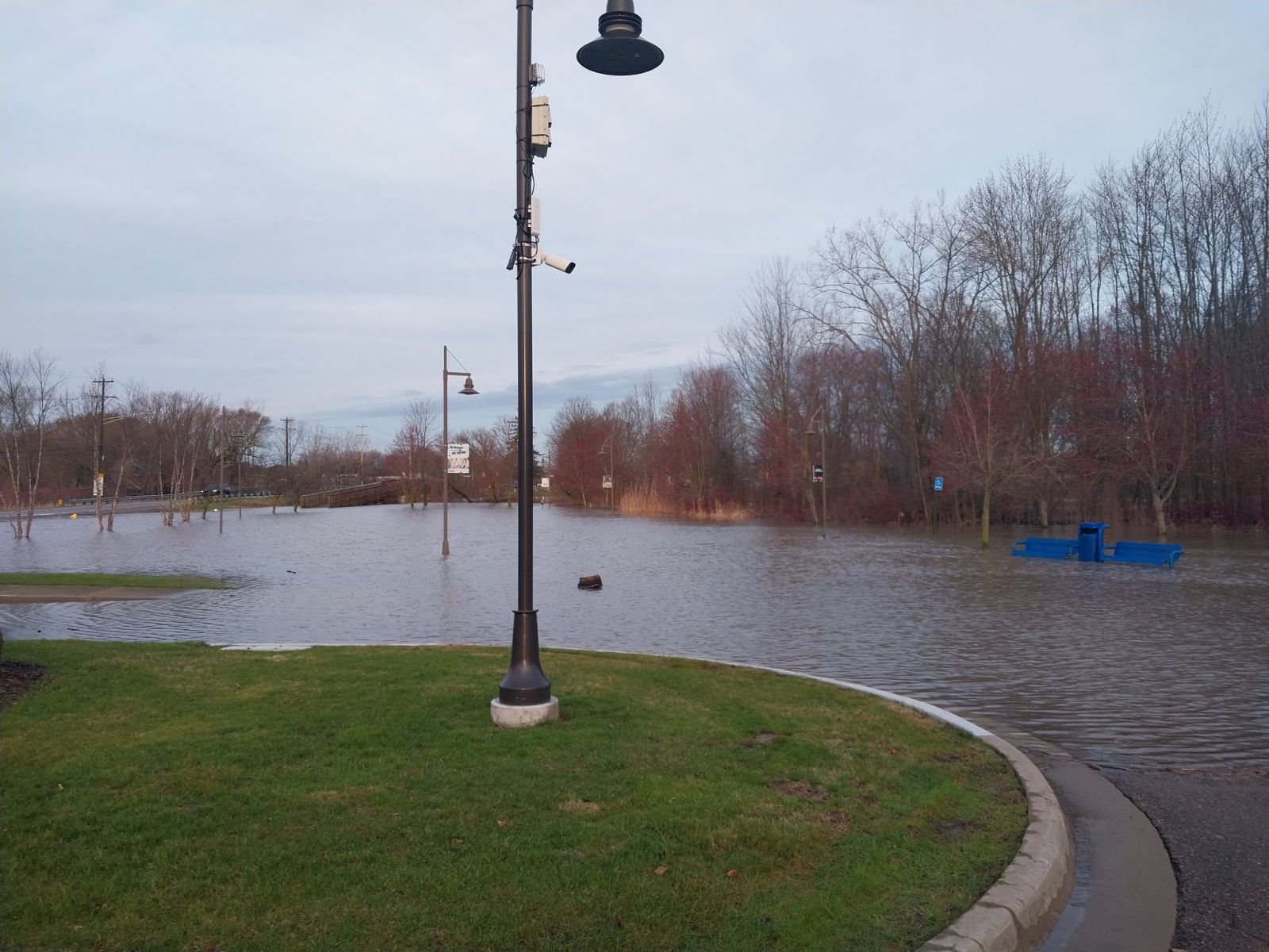
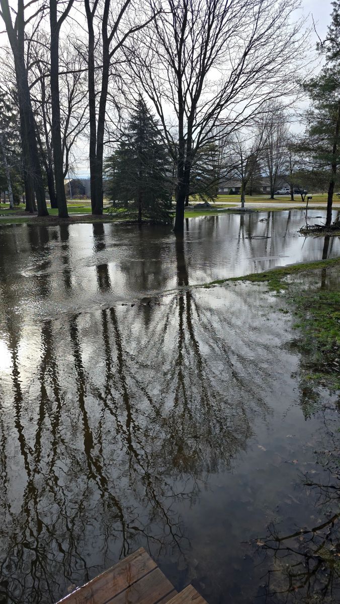
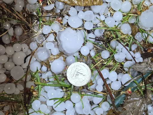
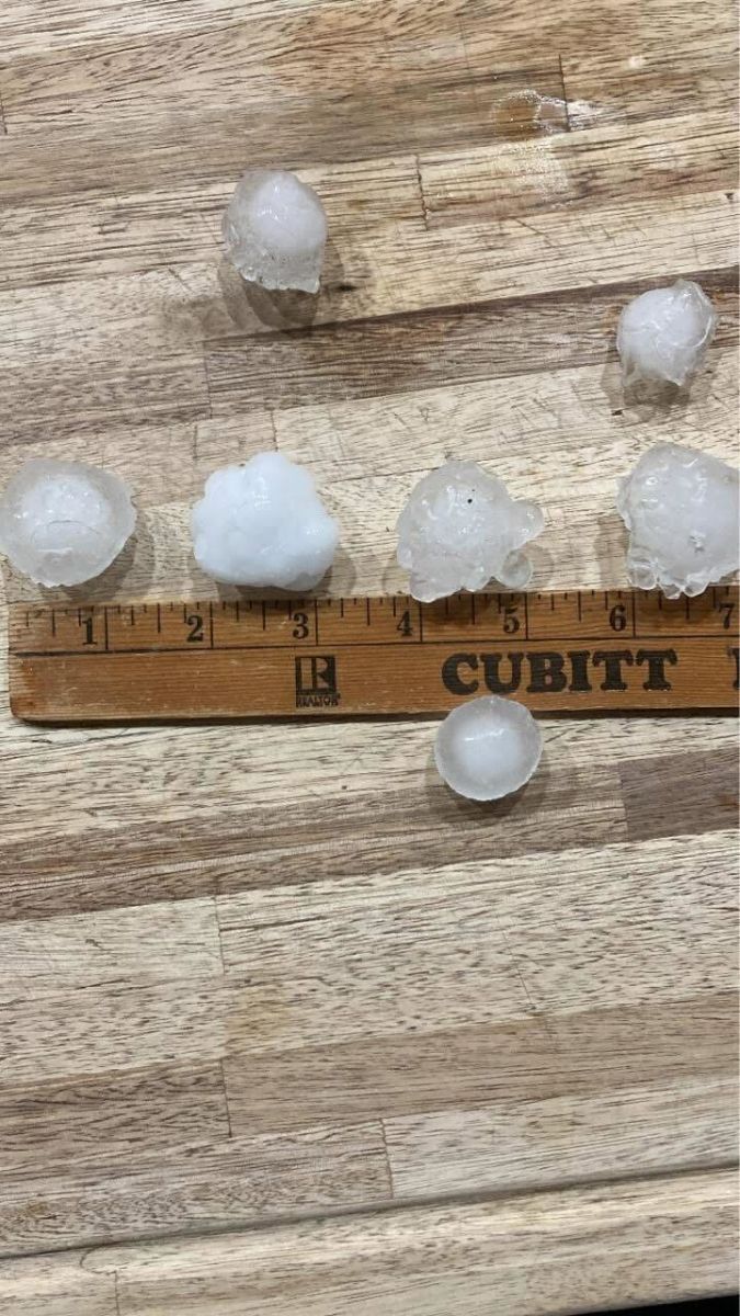
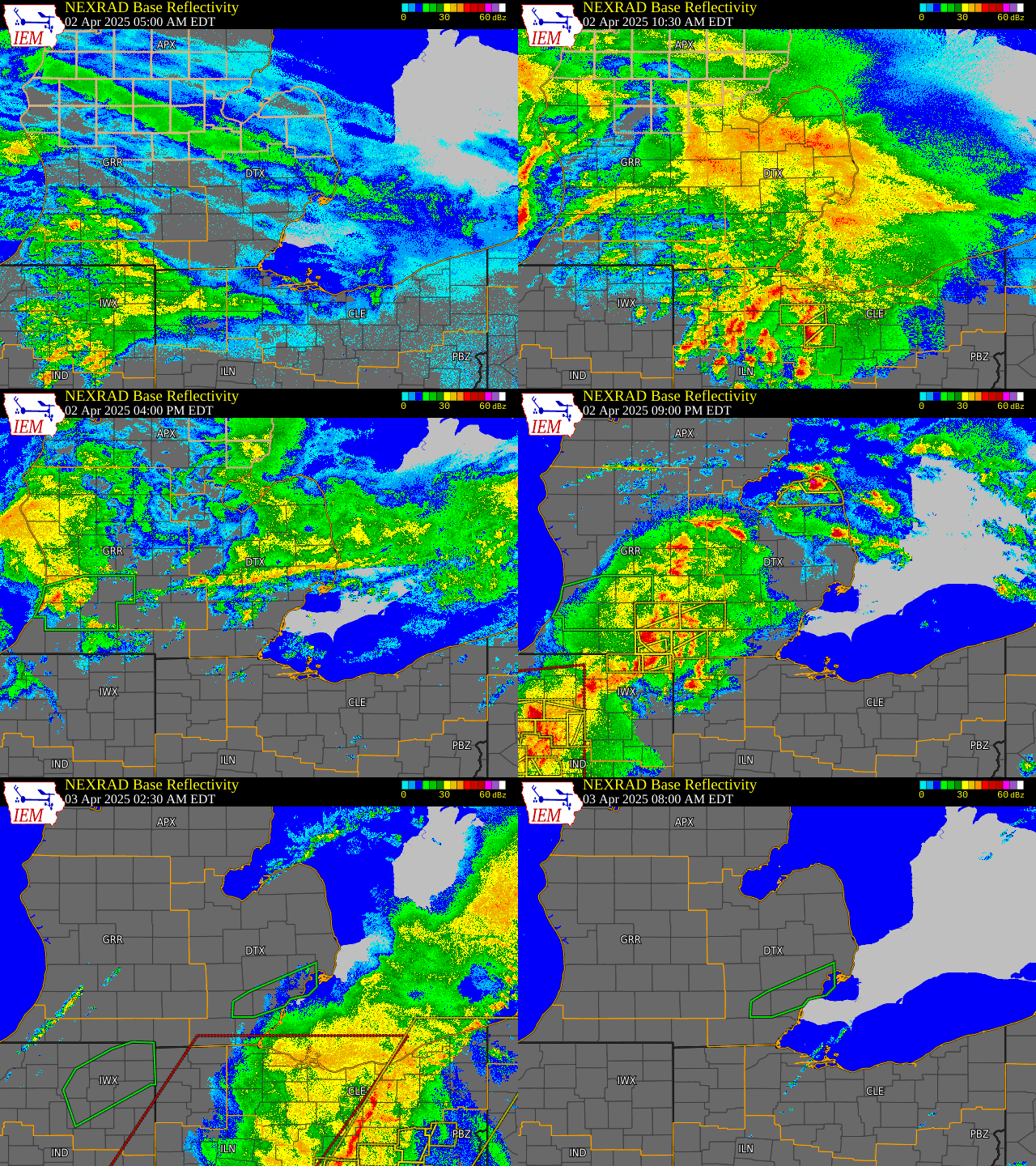
Morning snow, light freezing rain, and some sleet transitioned to rain showers and thunderstorms by midday on April 2nd. An anomalously warm and humid low-level air mass moved into Lower Michigan while the surface warm front lagged well to the south, over the Ohio Valley. Numerous rounds of repeated rainfall during the day and overnight led to several areas across Metro Detroit receiving between 2" and 3" of rainfall within a 24 hour period. This led to multiple reports of flooded roadways, stranded vehicles, basement flooding, and water damage to businesses. A new daily maximum rainfall record was set for Detroit with 2.18" on April 2nd, breaking the previous daily record of 1.44" set in 1945. A new daily maximum rainfall record was also set for Flint with 1.75" for April 2nd, breaking the previous daily record of 1.62" set in 1945. In addition to flooding, a severe thunderstorm tracked across the Tri-Cities and Inner Saginaw Bay late evening, before moving back on land over Huron County. This storm produced large damaging hail with reports of 1.25" (half dollar sized) and 1.5" (ping-pong ball sized) hail (see Photos section). |
Photos & Video
 |
 |
 |
 |
| Livonia, MI (Courtesy of Ben Redmon) |
Clinton River at 21 Mile, MI (Courtesy of Nader Chasin) |
Casco, MI (Courtesy of The Detroit Scanner) |
Casco, MI (Courtesy of The Detroit Scanner) |
 |
 |
 |
|
| Caseville, MI (Courtesy of Toria Kanaby via Broadcast Media) |
Pigeon, MI (Courtesy of Facebook/Broadcast Media) |
Oak Beach, MI (Courtesy of Facebook/Michigan EGLE) |
Radar
 |
 |
| Radar loop courtesy of Iowa Environmental Mesonet (IEM) |
Storm Reports - Rainfall Totals
Local Storm Reports (Rainfall Totals):

Public Information Statement...Summary
National Weather Service Detroit/Pontiac MI
1009 AM EDT Thu Apr 3 2025


STORM TOTAL RAIN REPORTS

Location                   Precip      Duration
                          (Inches)      (Hours)        Lat       Lon

...Bay County...
   1 NE Bay City           M  1.22           24     43.59N    83.89W
   Auburn                  M  1.30           24     43.60N    84.08W

...Genesee County...
   4 N Burton              M  1.37          7.5     43.05N    83.62W
   4 N Burton              M  2.27           24     43.05N    83.62W
   Flint                   M  2.43           24     43.02N    83.69W

...Huron County...
   Bad Axe                 M  1.03           24     43.80N    83.00W
   Port Austin             M  1.80           24     44.04N    83.00W

...Lapeer County...
   1 N North Branch        M  2.05           24     43.25N    83.19W

...Lenawee County...
   Morenci                 M  2.01           24     41.72N    84.22W
   Tipton                  M  2.75           24     42.02N    84.06W

...Livingston County...
   4 NW Pinckney           M  1.21           12     42.50N    84.00W
   Fowlerville             M  2.85           24     42.66N    84.07W

...Macomb County...
   Richmond                M  1.84           24     42.81N    82.75W
   2 E Chesterfield        M  1.94           24     42.66N    82.80W
   1 E Roseville           M  2.31           24     42.50N    82.94W
   5 NE Sterling Heights   M  2.64           24     42.63N    82.96W
   Macomb Township         M  2.88           24     42.67N    82.92W

...Midland County...
   2 NE Midland            M  1.00           24     43.64N    84.21W

...Monroe County...
   6 NW Monroe             M  1.35           24     41.98N    83.47W
   Dundee                  M  1.63           24     41.96N    83.66W

...Oakland County...
   4 SW Ortonville         M  1.10          7.5     42.81N    83.50W
   4 E White Lake          M  1.33          8.5     42.65N    83.43W
   Leonard                 M  1.70           12     42.87N    83.14W
   Bloomfield Hills        M  1.77           24     42.58N    83.25W
   Farmington Hills        M  1.84           24     42.49N    83.38W
   Troy                    M  2.11           18     42.58N    83.14W
   Farmington              M  2.14           24     42.46N    83.38W
   1 E White Lake          M  2.24           24     42.65N    83.50W
   Leonard                 M  2.53           24     42.87N    83.14W
   Madison Heights         M  2.58           23     42.49N    83.11W
   Ortonville              M  2.68           24     42.85N    83.44W
   1 SW Ferndale           M  3.06           24     42.46N    83.13W
   1 ENE Lake Orion        M  3.21           24     42.78N    83.24W

...Saginaw County...
   3 S Nelson              M  1.03            6     43.29N    84.25W
   Saginaw                 M  1.51           24     43.42N    83.95W
   Oakley                  M  2.30           24     43.14N    84.17W

...Sanilac County...
   Lexington               M  2.53           24     43.27N    82.53W

...Shiawassee County...
   Owosso                  M  2.20           24     43.00N    84.18W

...St. Clair County...
   3 N St Clair County Int M  2.17           24     42.95N    82.53W

...Tuscola County...
   Cass City               M  1.77           24     43.60N    83.18W

...Washtenaw County...
   Manchester              M  2.45           24     42.15N    84.04W
   4 SE Ann Arbor          M  2.57           25     42.23N    83.68W
   1 S Pittsfield Township M  3.07           24     42.19N    83.72W

...Wayne County...
   Wyandotte               M  1.80           24     42.21N    83.15W
   Southgate               M  2.08           24     42.21N    83.19W
   2 SE Romulus            M  2.28           24     42.20N    83.34W
   Garden City             M  2.83           24     42.33N    83.33W


M = Measured
E = Estimated
Observations are collected from a variety of sources with varying
equipment and exposures. We thank all volunteer weather observers
for their dedication. Not all data listed are considered official.
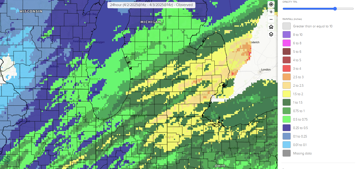 |
| Rainfall estimates via National Water Prediction Service: water.noaa.gov |
Hail
Preliminary Local Storm Report
National Weather Service Detroit/Pontiac MI
859 PM EDT Wed Apr 02 2025

..TIME...   ...EVENT...      ...CITY LOCATION...     ...LAT.LON...
..DATE...   ....MAG....      ..COUNTY LOCATION..ST.. ...SOURCE....
            ..REMARKS..

0856 PM     Hail             Port Austin             44.04N  83.00W
04/02/2025  M1.00 inch       Huron              MI   Trained Spotter
0842 PM     Hail             Pigeon                  43.83N  83.27W
04/02/2025  M1.00 inch       Huron              MI   Public

            Photos sent on Facebook.

0850 PM     Hail             4 E Caseville           43.94N  83.19W
04/02/2025  E1.50 inch       Huron              MI   Public

            Size estimated from photo on Facebook.

0852 PM     Hail             3 NE Lake Township      43.99N  83.12W
04/02/2025  M1.25 inch       Huron              MI   Public

            Photo found on Facebook
 |
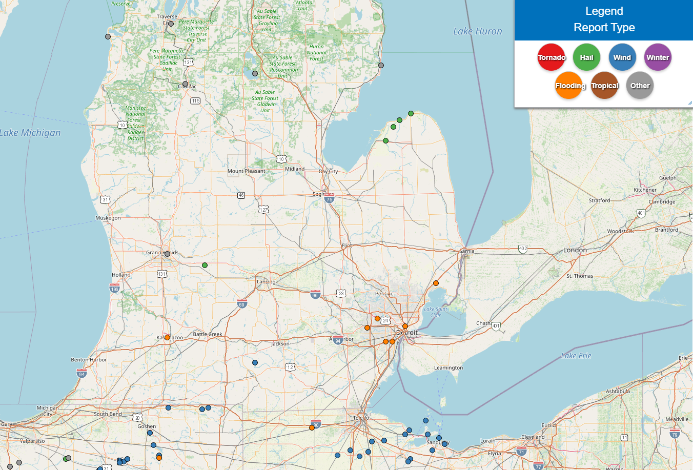 |
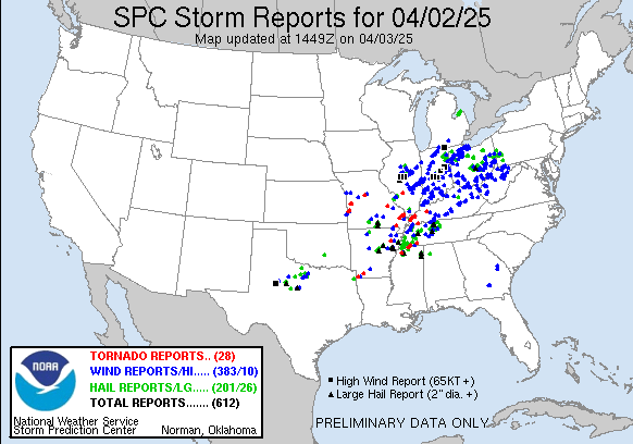
| SPC Storm Reports for April 2, 2025 | Local Storm Reports for April 2, 2025 |
Environment
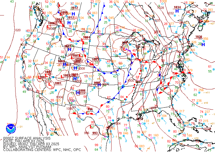
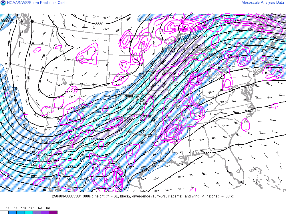
A strong upper level jet extending from the Desert Southwest through the Great Lakes provided energetic winds aloft (Fig. 3) as a surface low tracked from the Missouri River Basin to the Upper Midwest. A surface warm front extending southeastward from the low struggled to lift northward across the Ohio Valley (Fig. 1) while the elevated portion of the boundary advanced more aggressively into Lower Michigan. The coupled low-level jet helped sustain efficient moisture transport into the region with PWATs climbing into the 1.25 inch to 1.50 inch range (Fig. 4). These values exceeded sounding climatology for KDTX with the April 3rd 00Z KDTX sounding having sampled a PWAT of 1.31 inches.
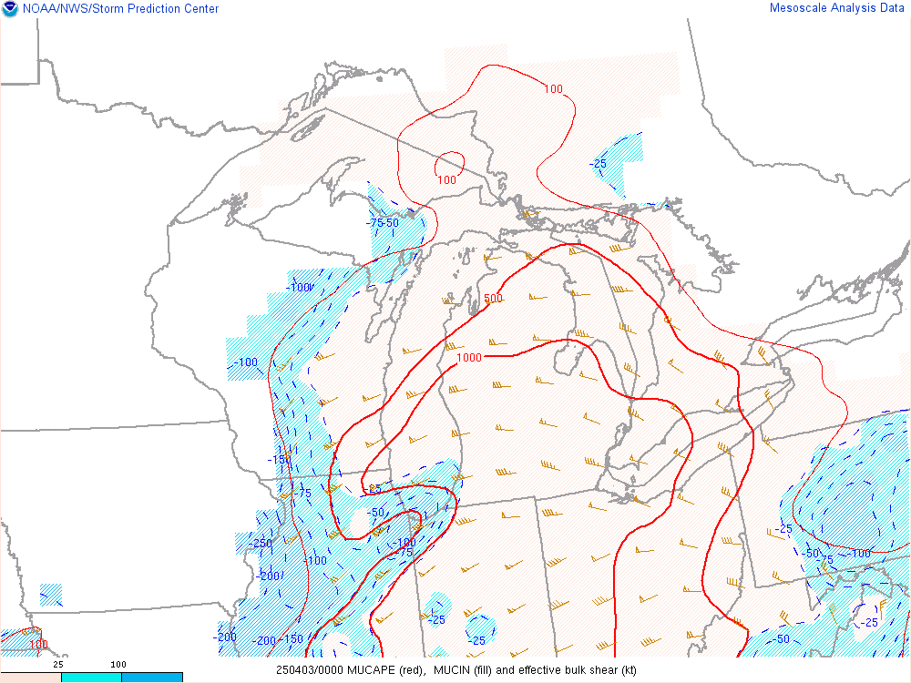
An impressive temperature inversion was noted in the evening RAOB marked by a surface temperature of 39F (3.8C) and a 900 mb/922 m temperature of 63.5F (17.5C) at the top of the inversion. This yielded a temperature difference of 24.7F (13.7C) in less than a kilometer (Fig. 2). The inversion proved formidable through 03Z as the Elevated Mixed Layer (EML) supported persistent MUCAPE of over 1,000 J/kg (Fig. 5). Early in the event, a severe thunderstorm latched onto a mesoscale boundary and capitalized on elevated tall/skinny CAPE as it tracked across the Tri-Cities and Inner Saginaw Bay late into the evening. The storm weakened slightly before moving back on land over Huron County where impressive reflectivity values were detected (+70 dBZ, not shown) which highlighted the damaging hail threat.
In spite of the very strong low-level winds in excess of 55 mph (at 1 kft) with effective bulk shear (EBS) in excess of 45 knots (Fig. 5), the inversion layer prevented the mechanical mixing of strong gusty winds which kept thunderstorm wind gusts below 40 mph. The primary threat south of M-46 was the torrential rainfall with a delayed departure of the primary, secondary, and tertiary convective bands which featured redevelopment along the back edge past midnight. A final sub-severe convective line worked through during the early morning hours on April 3rd which resulted in some rainfall totals in excess of 3”.
 |
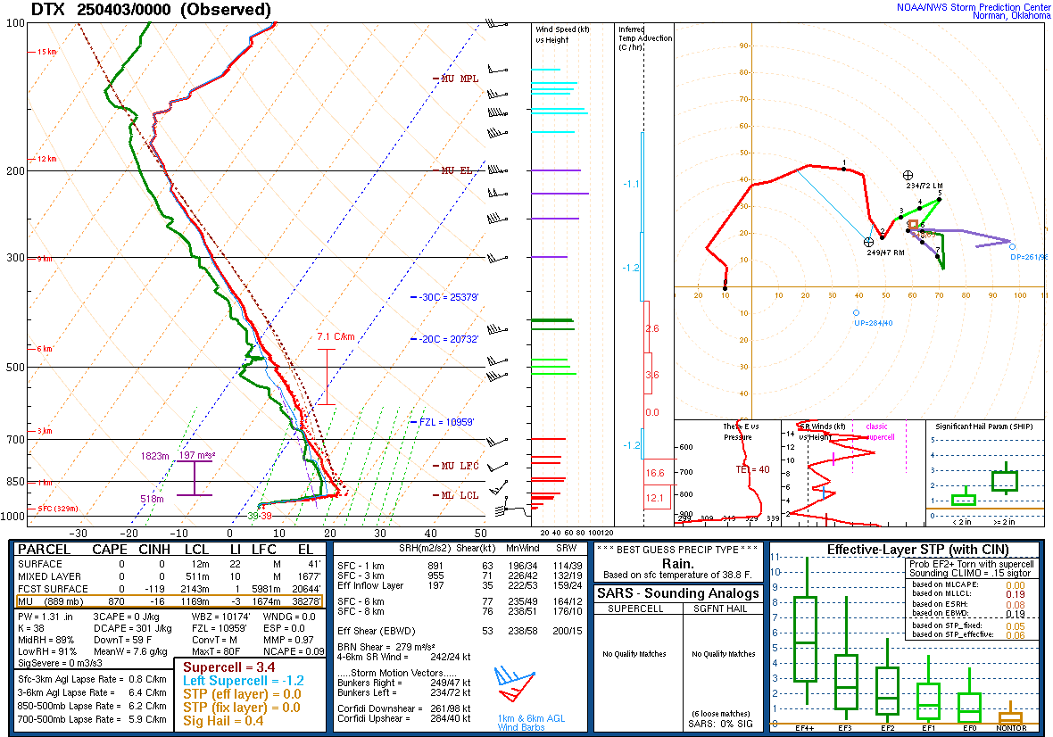 |
| Figure 1: WPC Surface Analysis, valid 00 UTC 03 April 2025 | Figure 2: DTX Sounding, valid 00 UTC 03 April 2025 |
 |
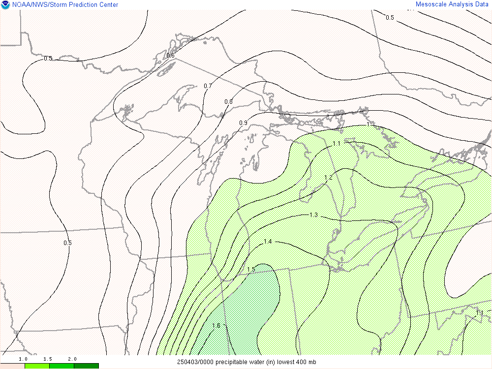 |
| Figure 3: 300 mb Level Analysis, valid 00 UTC 03 April 2025 | Figure 4: Precipitable Water (in) in lowest 400mb, valid 00 UTC 03 April 2025 |
 |
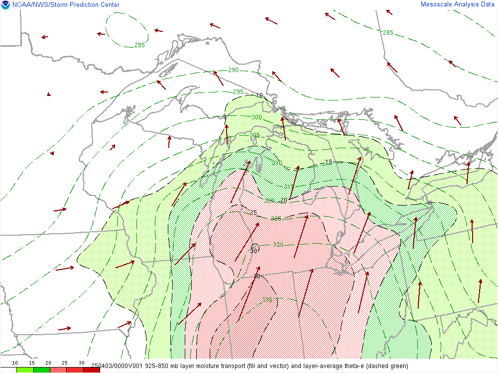 |
| Figure 5: MUCAPE and Effective Bulk Shear, valid 00 UTC 03 April 2025 | Figure 6: 850 mb Moisture Transport, valid 00 UTC 03 April 2025 |
 |
Media use of NWS Web News Stories is encouraged! Please acknowledge the NWS as the source of any news information accessed from this site. |
 |