Overview
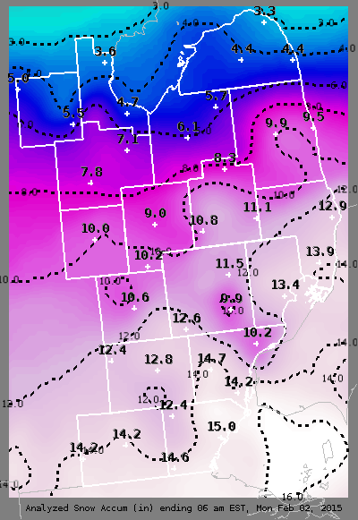
February started off quite active, as a long duration snow event unfolded across the region bringing the first significant snowfall to Southeast Michigan this winter season. Over the past few months, the area had managed to avoid a lot of the snow while other states have not had such luck. Up through the end of January, areas were below normal for snowfall compared to the record breaking winter season of '13-'14. Then came the storm that ended up dropping over a foot of snow at Detroit Metro Airport!
A strong low pressure system developed across the Great Plains and drifted across lower Michigan on Sunday and Sunday night. Snow began in the southern counties around 1am Sunday and continued throughout the day on Sunday. Better moisture arrived by mid-afternoon resulting in heavier snowfall rates (up to an inch per hour in some locations). The system finally pushed east of the region round 7am Monday morning. This long duration winter storm resulted in snowfall totals between 9 and 15 inches across the Metro Detroit area, with slightly lower amounts across the Thumb and Saginaw Valley regions (3-6 inches).
Back to top
Radar
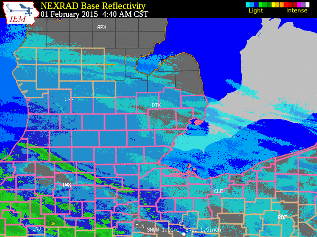 |
| Radar loop courtesy of Iowa Environmental Mesonet (IEM). Peach colored boxes are winter weather advisories and pink boxes are winter storm warnings. |
Back to top
Snowfall Reports
PUBLIC INFORMATION STATEMENT...STORM TOTALS
NATIONAL WEATHER SERVICE DETROIT/PONTIAC MI
1048 AM EST MON FEB 2 2015
STORM TOTAL SNOW REPORTS
LOCATION SNOWFALL DURATION
(INCHES) (HOURS) LAT LON
...BAY COUNTY...
AUBURN M 7.2 24 43.60N 84.08W
...GENESEE COUNTY...
GOODRICH M 8.5 27 42.92N 83.51W
4 N BURTON M 8.9 27 43.05N 83.62W
7 W FLINT M 8.9 26 43.02N 83.83W
FLINT M 9.2 28 43.02N 83.69W
LINDEN M 10.2 28 42.82N 83.78W
...HURON COUNTY...
5 NNW FILION M 4.2 24 43.96N 83.04W
BAD AXE M 6.0 25 43.80N 83.00W
...LAPEER COUNTY...
4 E DAVISON M 11.0 24 43.03N 83.44W
LAPEER M 11.9 28 43.05N 83.32W
2 W LAPEER M 12.3 28 43.05N 83.36W
...LENAWEE COUNTY...
2 WSW TIPTON M 9.5 30 42.01N 84.10W
MORENCI M 11.7 30 41.72N 84.22W
...LIVINGSTON COUNTY...
HOWELL M 10.2 28 42.61N 83.94W
1 N WHITMORE LAKE M 11.0 29 42.44N 83.75W
BRIGHTON E 12.5 M 42.53N 83.78W
...MACOMB COUNTY...
1 NW ROSEVILLE M 10.0 26 42.52N 82.95W
4 NNW RICHMOND M 11.7 28 42.86N 82.78W
SHELBY TOWNSHIP M 15.5 25 42.67N 83.03W
...MIDLAND COUNTY...
MIDLAND M 4.0 24 43.62N 84.23W
OIL CITY M 6.0 24 43.61N 84.59W
...MONROE COUNTY...
DUNDEE M 12.0 30 41.96N 83.66W
CARLETON M 13.1 29 42.06N 83.39W
MONROE M 14.0 28 41.92N 83.39W
3 SW MONROE M 15.0 30 41.89N 83.43W
4 SSE NEWPORT M 15.0 30 41.95N 83.28W
...OAKLAND COUNTY...
1 N FARMINGTON HILLS M 9.0 28 42.50N 83.38W
HOLLY M 9.0 28 42.80N 83.62W
FARMINGTON HILLS M 9.2 28 42.49N 83.38W
CLARKSTON M 9.5 28 42.74N 83.42W
FARMINGTON M 10.6 28 42.46N 83.38W
2 S ORTONVILLE M 11.0 28 42.82N 83.44W
WHITE LAKE M 11.2 28 42.65N 83.50W
4 N NOVI M 11.5 26 42.53N 83.49W
4 N LIVONIA M 12.3 28 42.46N 83.37W
1 ENE ROCHESTER M 13.1 26 42.69N 83.10W
NW SOUTH LYON M 13.7 28 42.46N 83.65W
2 NW WATERFORD M 14.0 28 42.68N 83.42W
LAKEVILLE M 14.0 28 42.82N 83.15W
2 SE LEONARD M 15.0 30 42.85N 83.12W
...SAGINAW COUNTY...
5 S MERRILL M 5.0 24 43.34N 84.34W
2 E MERRILL M 6.0 26 43.41N 84.30W
FRANKENMUTH M 7.4 27 43.33N 83.74W
HEMLOCK M 7.5 24 43.42N 84.23W
SAGINAW M 7.5 27 43.42N 83.95W
CHESANING M 7.7 27 43.18N 84.12W
...SANILAC COUNTY...
LEXINGTON M 10.0 24 43.27N 82.53W
SANDUSKY M 10.0 24 43.42N 82.83W
...SHIAWASSEE COUNTY...
2 NE CORUNNA M 7.0 24 43.00N 84.09W
6 WNW DURAND M 10.5 28 42.95N 84.10W
OWOSSO M 10.5 28 43.00N 84.18W
SHAFTSBURG M 13.2 28 42.80N 84.29W
...ST. CLAIR COUNTY...
1 NNW YALE M 12.2 28 43.14N 82.80W
COLUMBUS M 12.3 25 42.89N 82.67W
ALGONAC M 14.0 27 42.62N 82.53W
...TUSCOLA COUNTY...
CARO M 5.5 26 43.49N 83.40W
1 SSW CASS CITY M 6.5 28 43.59N 83.18W
VASSAR M 7.0 26 43.37N 83.58W
...WASHTENAW COUNTY...
SALINE M 9.5 29 42.18N 83.78W
2 WNW ANN ARBOR M 12.0 29 42.29N 83.77W
SALEM M 12.0 28 42.41N 83.58W
CHELSEA M 12.2 29 42.31N 84.02W
3 SW YPSILANTI M 12.8 29 42.21N 83.66W
MANCHESTER M 13.0 29 42.15N 84.04W
SE ANN ARBOR M 13.5 29 42.28N 83.73W
ANN ARBOR M 14.1 29 42.28N 83.73W
3 NNW MILAN M 15.0 29 42.13N 83.72W
...WAYNE COUNTY...
GROSSE POINTE FARMS M 9.5 29 42.40N 82.89W
DEARBORN M 9.6 29 42.31N 83.21W
3 NE DEARBORN M 10.0 29 42.34N 83.17W
1 NW DEARBORN HEIGHTS M 12.8 M 42.34N 83.29W
2 NNW LIVONIA M 13.5 29 42.42N 83.39W
GARDEN CITY M 13.5 29 42.33N 83.33W
ALLEN PARK M 14.0 28 42.26N 83.21W
NORTHVILLE M 14.2 30 42.44N 83.49W
1 WSW DEARBORN M 14.5 29 42.31N 83.23W
WYANDOTTE M 16.5 28 42.21N 83.16W
ROMULUS M 16.7 28 42.22N 83.37W
BROWNSTOWN TOWNSHIP M 17.0 28 42.15N 83.26W
M = MEASURED
E = ESTIMATED
Back to top
Additional Resources
Event Summaries from area NWS Offices:
NWS Northern Indiana
Back to top

