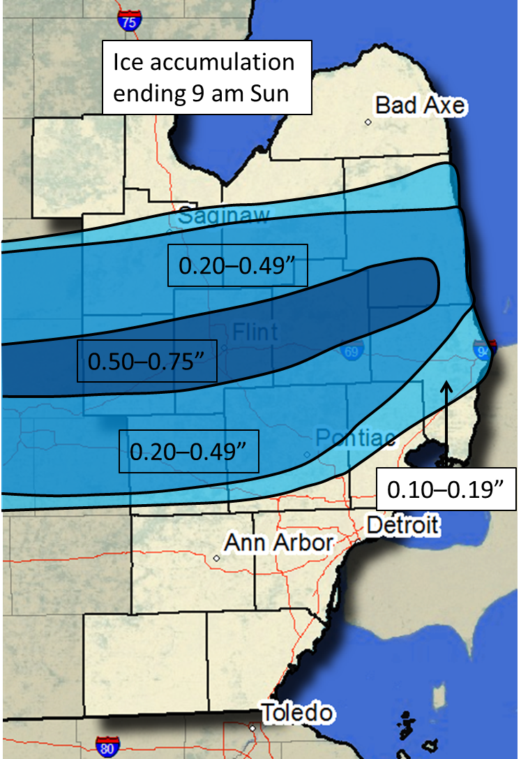
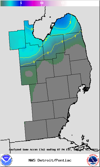
A winter storm impacted a large swath of the country from the southern Plains through the Midwest and into the Northeast on the last weekend before Christmas. This storm occurred as a deep upper-level trough over the Desert Southwest lifted northeastward, while a surface low pressure system moved from Texas into the Ohio Valley. This low moved along a very sharp frontal boundary. This front at the surface actually briefly penetrated far southeastern Michigan Friday night. The temperature at Lambertville, on the Ohio border, rose into the mid-50s, while Monroe, just 15 miles away, stayed in the mid-30s. On Saturday, copious Gulf moisture was brought northward ahead of the approaching surface low. This warm, moist air was forced to ascend at the front over Ohio, spreading precipitation from south to north over the DTX CWA from the late morning into the afternoon. An anticyclone over Ontario provided a supply of low-level cold air, causing the surface temperature to be near or below freezing for much of southeast Michigan. The result was a swath of freezing rain roughly between M-59 to M-46 which continued into Saturday night and early Sunday. The I-69 corridor was especially hard-hit, with ice accumulations of over 0.50" causing tens of thousands of people to lose power. Numerous trees and wires were downed, and a state of emergency was declared in Shiawassee County due to unsafe traveling conditions. South of M-59, much of the precipitation occurred as rain, with some locations receiving over 1.50" rain. North of M-46, much of the precipitation occurred as snow, with up to 4 inches reported.
PUBLIC INFORMATION STATEMENT...STORM TOTALS
NATIONAL WEATHER SERVICE DETROIT/PONTIAC MI
1051 AM EST SUN DEC 22 2013
STORM TOTAL FREEZING RAIN REPORTS
LOCATION PRECIP DURATION
(INCHES) (HOURS) LAT LON
...GENESEE COUNTY...
4 SSE BIRCH RUN E 0.20 M 43.20N 83.77W
LINDEN M 0.25 M 42.82N 83.78W
FLINT E 0.50 M 43.02N 83.69W
FLINT E 0.50 M 43.02N 83.69W
...LAPEER COUNTY...
METAMORA E 0.25 M 42.94N 83.29W
2 W LAPEER E 0.50 M 43.05N 83.36W
LAPEER E 0.50 M 43.05N 83.32W
LAPEER M 0.50 M 43.05N 83.32W
...LIVINGSTON COUNTY...
3 ESE HOWELL E 0.20 M 42.59N 83.88W
4 S FENTON M 0.40 M 42.75N 83.72W
...MACOMB COUNTY...
ROMEO E 0.25 M 42.80N 83.01W
...OAKLAND COUNTY...
4 E WHITE LAKE M 0.25 M 42.65N 83.43W
4 SW LAKE ORION E 0.25 M 42.74N 83.29W
CLARKSTON E 0.25 M 42.74N 83.42W
HOLLY M 0.25 M 42.80N 83.62W
NOVI E 0.25 M 42.48N 83.49W
ORTONVILLE E 0.25 M 42.85N 83.44W
WATERFORD E 0.25 M 42.66N 83.39W
WATERFORD E 0.25 M 42.66N 83.39W
...SAGINAW COUNTY...
SAGINAW E 0.25 M 43.42N 83.95W
ST. CHARLES E 0.25 M 43.30N 84.15W
...SANILAC COUNTY...
SANDUSKY E 0.25 M 43.42N 82.83W
BROWN CITY E 0.50 M 43.21N 82.99W
...SHIAWASSEE COUNTY...
PERRY M 0.40 M 42.82N 84.23W
OWOSSO E 0.50 M 43.00N 84.18W
...ST. CLAIR COUNTY...
PORT HURON E 0.10 M 42.99N 82.43W
YALE M 0.25 M 43.13N 82.80W
3 N CAPAC E 0.30 M 43.06N 82.93W
...TUSCOLA COUNTY...
3 E DEFORD M 0.40 M 43.51N 83.13W
STORM TOTAL HEAVY RAIN REPORTS
LOCATION PRECIP DURATION
(INCHES) (HOURS) LAT LON
...LENAWEE COUNTY...
ADRIAN M 1.10 24 41.90N 84.04W
TECUMSEH M 1.23 24 42.01N 83.94W
1 SW BLISSFIELD M 1.60 24 41.82N 83.88W
...MACOMB COUNTY...
NEW BALTIMORE M 1.07 24 42.68N 82.74W
...MONROE COUNTY...
DUNDEE M 1.55 24 41.96N 83.66W
...OAKLAND COUNTY...
FERNDALE M 1.10 24 42.46N 83.13W
...ST. CLAIR COUNTY...
ALGONAC M 1.08 24 42.62N 82.53W
...WASHTENAW COUNTY...
YPSILANTI M 1.03 24 42.24N 83.62W
ANN ARBOR M 1.08 24 42.28N 83.73W
MANCHESTER M 1.15 24 42.15N 84.04W
...WAYNE COUNTY...
ROMULUS M 1.10 24 42.22N 83.37W
STORM TOTAL SNOW REPORTS
LOCATION SNOWFALL DURATION
(INCHES) (HOURS) LAT LON
...BAY COUNTY...
BAY CITY M 2.3 M 43.59N 83.89W
PINCONNING M 3.0 14 43.86N 83.96W
AUBURN M 4.2 12 43.60N 84.08W
...HURON COUNTY...
BAD AXE M 3.0 12 43.80N 83.00W
PORT AUSTIN M 3.5 12 44.04N 83.00W
6 E PORT AUSTIN M 3.9 12 44.04N 82.87W
5 NNW FILION M 4.1 12 43.96N 83.04W
...MIDLAND COUNTY...
MIDLAND M 1.0 M 43.62N 84.23W
OIL CITY M 2.0 12 43.61N 84.59W
...SAGINAW COUNTY...
3 N SAGINAW M 1.8 M 43.46N 83.95W
3 NW SAGINAW M 2.5 14 43.45N 83.99W
M = MEASURED
E = ESTIMATED

