Overview
A strong low pressure lifted northeast across southeast Michigan beginning during the evening hours of February 4th, 2021, and continuing into February 5th, 2021 bringing accumulating snowfall to the region. Most areas saw 1-3 inches of accumulating snow, with portions of the greater Detroit metro region seeing the highest snowfall totals of locally 2-4+ inches. This storm system was notable in the fact that the bulk of the snow fell within a strongly forced snow band primarily during the hours of 6pm-11pm February 4th, with snowfall rates around 1 inch per hour across many areas resulting in quick wet snow accumulations. A strong cold front accompanying the system then raced east across the state bringing widespread wind gusts peaking generally in the 40-45 mph range during the early morning hours of February 5th. This storm system set the stage for the coldest Arctic air of the 2020-2021 winter season, which was set to bring a prolonged period of periodic wind chills below zero degrees along with intervals of lake effect snow.
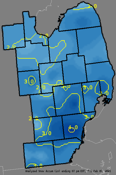
Here is a graphical representation of the amount of snowfall that fell beginning around 6pm February 4th, 2021 and ending approximately 7am February 5th 2021. Note, this depiction is an approximation and is based on local observations. Also of note is that some of these totals may be skewed by significant blowing snow effects.