Overview
Event Summary
A strong upper trough moved through the Great Lakes on February 13, 2022 and led to a round of convective snow showers along the I-96/I-696 and I-94 corridors that intensified during the late afternoon and early evening. Snowfall rates in excess of an inch per hour were observed around northwest Metro Detroit as localized banding set up for several hours. Some locations around Livonia received 6 inches by the time snow showers tapered off by 8pm. This snowfall led to numerous accidents and the closing of several stretches of interstate highways.
The event was characterized by strong convergence and steep lapse rates in the low-levels that resulted in robust vertical motion as the trough moved overhead. A plume of modest instability that stretched eastward across the state and between the M-59 and I-94 corridors highlighted the main area of activity. The cold air mass in place (temps in the teens) meant the dendritic growth zone was relatively low in the column and flake sizes were small in the weaker activity. The strongest convection was however able to lower the cloud base and capitalize on this layer to produce large aggregate dendrites with extremely efficient snowfall rates.
Radar
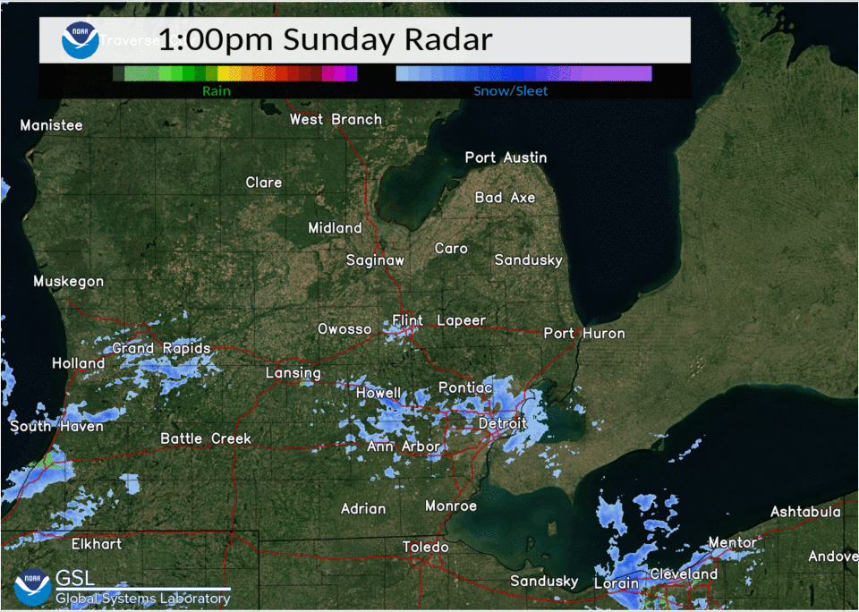 |
|
Radar loop from 1pm to 7pm Sunday February 13, 2022 |
Storm Reports

PRELIMINARY LOCAL STORM REPORT...SUMMARY
NATIONAL WEATHER SERVICE DETROIT/PONTIAC MI
1139 AM EST MON FEB 14 2022

..TIME...   ...EVENT...      ...CITY LOCATION...     ...LAT.LON...
..DATE...   ....MAG....      ..COUNTY LOCATION..ST.. ...SOURCE....
            ..REMARKS..

0545 PM     SNOW             2 WSW WOLVERINE LAKE    42.55N 83.51W
02/13/2022  M3.0 INCH        OAKLAND            MI   TRAINED SPOTTER

            4 HOUR SNOWFALL TOTAL.

0700 PM     SNOW             3 N LIVONIA             42.44N 83.38W
02/13/2022  M6.0 INCH        WAYNE              MI   NWS EMPLOYEE

            5 HOUR SNOWFALL TOTAL. REPORTED FROM RETIRED NWS
            EMPLOYEE.

0706 PM     SNOW             2 N LIVONIA             42.43N 83.37W
02/13/2022  M5.0 INCH        WAYNE              MI   PUBLIC

            6 HOUR SNOWFALL TOTAL.

0709 PM     SNOW             4 NE LIVONIA            42.43N 83.32W
02/13/2022  M5.3 INCH        WAYNE              MI   PUBLIC

            6 HOUR SNOWFALL TOTAL.

0800 PM     SNOW             GARDEN CITY             42.33N 83.33W
02/13/2022  M2.6 INCH        WAYNE              MI   TRAINED SPOTTER

            10 HOUR STORM TOTAL

0800 PM     SNOW             BERKLEY                 42.50N 83.19W
02/13/2022  M2.5 INCH        OAKLAND            MI   TRAINED SPOTTER

            6 HOUR STORM TOTAL.

0800 PM     SNOW             4 E LIVONIA             42.40N 83.30W
02/13/2022  M6.0 INCH        WAYNE              MI   PUBLIC

            6 HOUR SNOWFALL TOTAL. RELAYED VIA RETIRED NWS EMPLOYEE.

0800 PM     SNOW             BIRMINGHAM              42.54N 83.22W
02/13/2022  M4.0 INCH        OAKLAND            MI   PUBLIC

            6 HOUR SNOWFALL TOTAL. RELAYED VIA RETIRED NWS EMPLOYEE.

0830 PM     SNOW             ROMULUS                 42.22N 83.37W
02/13/2022  M2.2 INCH        WAYNE              MI   OFFICIAL NWS OBS

            7.5 HOUR SNOWFALL TOTAL AT DETROIT METRO AIRPORT. STORM
            TOTAL.

0830 PM     SNOW             WYANDOTTE               42.21N 83.16W
02/13/2022  M1.9 INCH        WAYNE              MI   TRAINED SPOTTER

            4 HOUR SNOWFALL TOTAL.

1100 PM     SNOW             FARMINGTON              42.46N 83.38W
02/13/2022  M3.0 INCH        OAKLAND            MI   CO-OP OBSERVER

            6 HOUR SNOWFALL TOTAL.

0500 AM     SNOW             2 NW DEARBORN HEIGHTS   42.35N 83.30W
02/14/2022  M1.0 INCH        WAYNE              MI   COCORAHS

            24 HOUR SNOWFALL TOTAL.

0600 AM     SNOW             1 N BERKLEY             42.51N 83.19W
02/14/2022  M3.3 INCH        OAKLAND            MI   COCORAHS

            24 HOUR SNOWFALL TOTAL.

0700 AM     SNOW             4 NE DEARBORN           42.35N 83.16W
02/14/2022  M1.5 INCH        WAYNE              MI   COCORAHS

            24 HOUR SNOWFALL TOTAL.

0700 AM     SNOW             3 SSE LIVONIA           42.36N 83.35W
02/14/2022  M2.5 INCH        WAYNE              MI   COCORAHS

            24 HOUR SNOWFALL TOTAL.

0700 AM     SNOW             1 N FRASER              42.55N 82.95W
02/14/2022  M1.5 INCH        MACOMB             MI   COCORAHS

            24 HOUR SNOWFALL TOTAL.

0700 AM     SNOW             3 S MONROE              41.87N 83.39W
02/14/2022  M1.4 INCH        MONROE             MI   COCORAHS

            24 HOUR SNOWFALL TOTAL.

0700 AM     SNOW             2 WNW FARMINGTON HILLS  42.50N 83.41W
02/14/2022  M4.5 INCH        OAKLAND            MI   COCORAHS

            24 HOUR SNOWFALL TOTAL.

0700 AM     SNOW             2 NE LIVONIA            42.42N 83.34W
02/14/2022  M3.5 INCH        WAYNE              MI   COCORAHS

            24 HOUR SNOWFALL TOTAL.

0700 AM     SNOW             3 SW BLOOMFIELD TOWNSHI 42.54N 83.30W
02/14/2022  M4.0 INCH        OAKLAND            MI   COCORAHS

            24 HOUR SNOWFALL TOTAL.

0725 AM     SNOW             2 NNW LIVONIA           42.42N 83.39W
02/14/2022  M3.7 INCH        WAYNE              MI   COCORAHS

            24 HOUR SNOWFALL TOTAL.

0730 AM     SNOW             SE ANN ARBOR            42.28N 83.73W
02/14/2022  M1.0 INCH        WASHTENAW          MI   CO-OP OBSERVER

            24 HOUR SNOWFALL TOTAL.

0800 AM     SNOW             4 NNE CHELSEA           42.37N 83.99W
02/14/2022  M1.0 INCH        WASHTENAW          MI   COCORAHS

            24 HOUR SNOWFALL TOTAL.

0915 AM     SNOW             4 WSW DETROIT           42.35N 83.17W
02/14/2022  M1.5 INCH        WAYNE              MI   CO-OP OBSERVER

            24 HOUR SNOWFALL TOTAL.
 |
Media use of NWS Web News Stories is encouraged! Please acknowledge the NWS as the source of any news information accessed from this site. |
|

