HOME
FORECAST
Local
Graphical
Aviation
Marine
Rivers and Lakes
Hurricanes
Severe Weather
Fire Weather
Sunrise/Sunset
Long Range Forecasts
Climate Prediction
Space Weather
PAST WEATHER
Past Weather
Astronomical Data
Certified Weather Data
SAFETY
INFORMATION
Wireless Emergency Alerts
Weather-Ready Nation
Brochures
Cooperative Observers
Daily Briefing
Damage/Fatality/Injury Statistics
Forecast Models
GIS Data Portal
NOAA Weather Radio
Publications
SKYWARN Storm Spotters
StormReady
TsunamiReady
Service Change Notices
EDUCATION
NEWS
SEARCH
Search For
NWS
All NOAA
ABOUT
About NWS
Organization
For NWS Employees
National Centers
Careers
Contact Us
Glossary
Social Media
NWS Transformation
Local forecast by
"City, St" or ZIP code
Sorry, the location you searched for was not found. Please try another search.
Multiple locations were found. Please select one of the following:
Location Help
News Headlines
April 14-15, 2026 Tornadoes & Severe Weather
🌧️ Volunteer Weather Observers Needed Across Southeast MI 🌧️
Virtual Spring Spotter Training Opportunities!
2026 In-Person Spring Skywarn Spotter Training Schedule
Expert Forecast Opinion
Additional Headlines
Customize Your
Weather.gov
Enter Your City, ST or ZIP Code
Remember Me
LOADING...
Detroit/Pontiac, MI
Weather Forecast Office
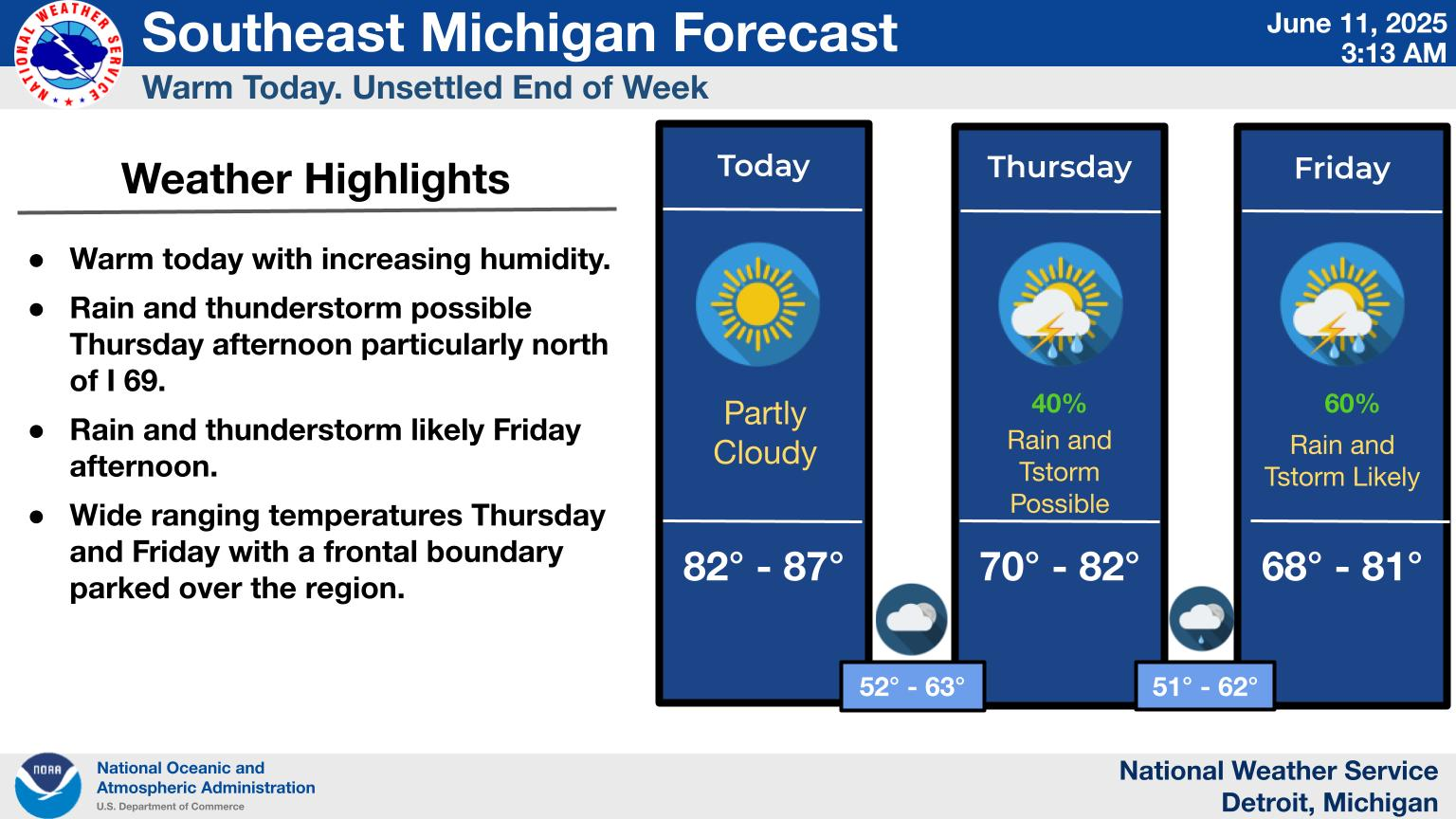
Weather Story
Weather.gov
>
Detroit/Pontiac, MI
> Weather Story
Current Hazards
Experimental Graphical Hazardous Weather Outlook
Storm and Precipitation Reports
Outlooks
Submit a Storm Report
Current Conditions
Local Snowfall Reports
Local Ice Accumulation Reports
Satellite
Observed Precipitation
Snowfall Analysis
Observations
Local Storm Reports
Radar
Local Standard Radar (low bandwidth)
Local Enhanced Radar
Regional Standard Radar (low bandwidth)
Forecasts
Fire Weather
Experimental Heat Risk
Experimental Probabilistic Quantitative Precipitation Forecast
Winter Weather
Forecast Discussion
Hourly Forecasts
Rivers and Lakes
National Water Prediction Service (NWPS)
Climate and Past Weather
Drought
Local
Event Summaries
NOAA Climate Service
Local Programs
Publications
Blog
Decision Support / Local Hazards
Snowfall Forecast
Marine Forecast
Todays Weather History
Our Office
Text Products
Beach Forecasts
Pronósticos en Español
Thunderstorm Outlook Tonight.
Excessive Rainfall Outlook Tonight
Marine Hazards
There is the potential for thunderstorms across Southeast Michigan tonight between 2am and 7am. No organized severe weather is anticipated.
Read More...
Marginal risk for excessive rainfall as a line of thunderstorms will be possible between 2am and 7am Saturday. Expected rainfall totals range from one half inch to three quarters of an inch.
Read More...
A Small Craft Advisory is in effect for the Lake Huron nearshore waters on Saturday.
Read More...
Follow us on X
Follow us on Facebook
Follow us on YouTube
DTX RSS Feed