Current Regional Radar

|
Current Hazards
|
Current Forecast
083
FZUS63 KDTX 141945
GLFLH
Open Lake Forecast for Lake Huron
National Weather Service Detroit/Pontiac MI
345 PM EDT Tue Jul 14 2026
For waters beyond five nautical miles off shore on Lake Huron
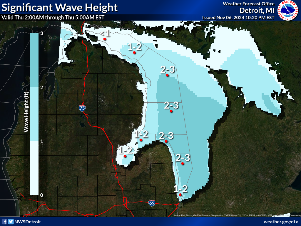
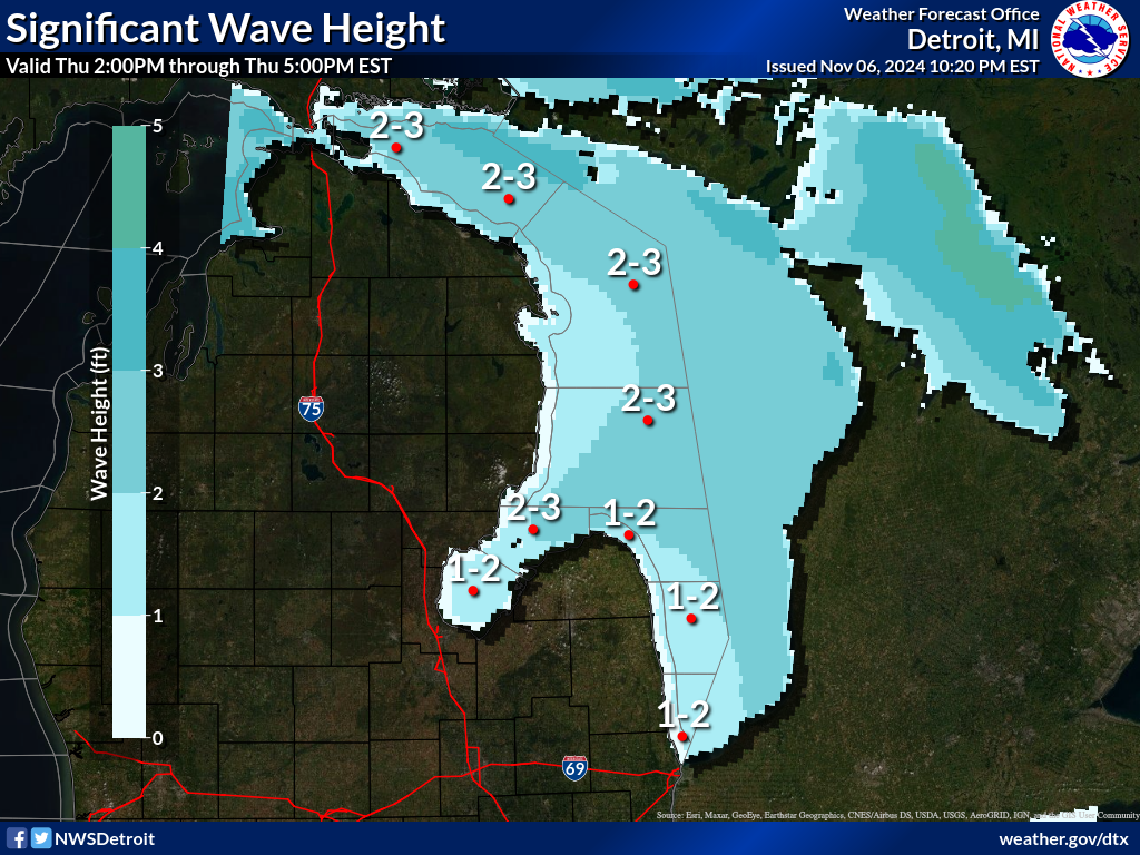
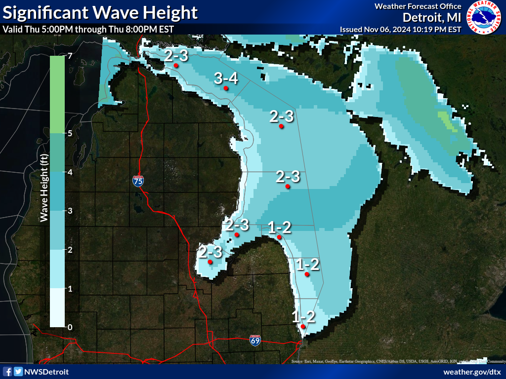
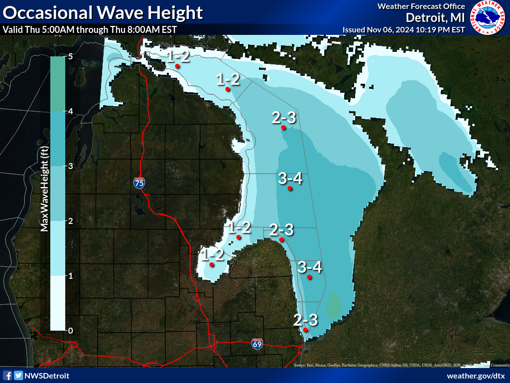
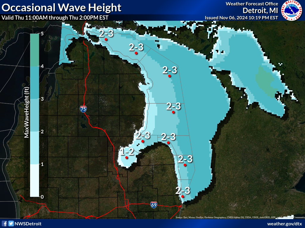
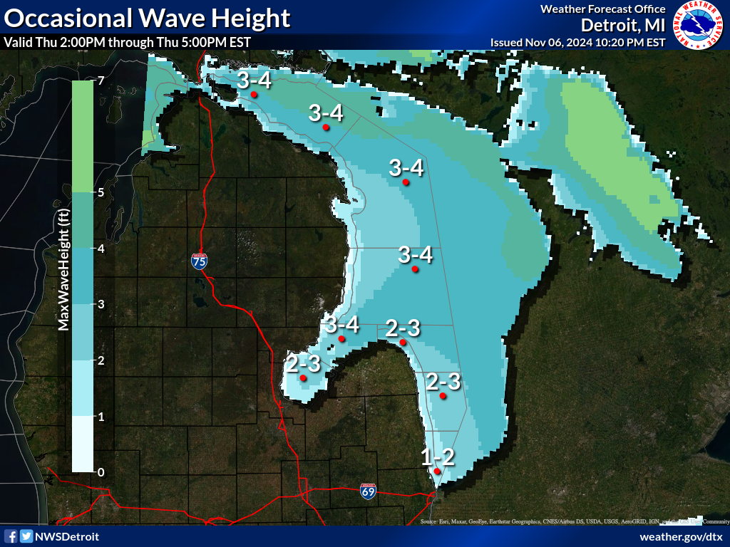
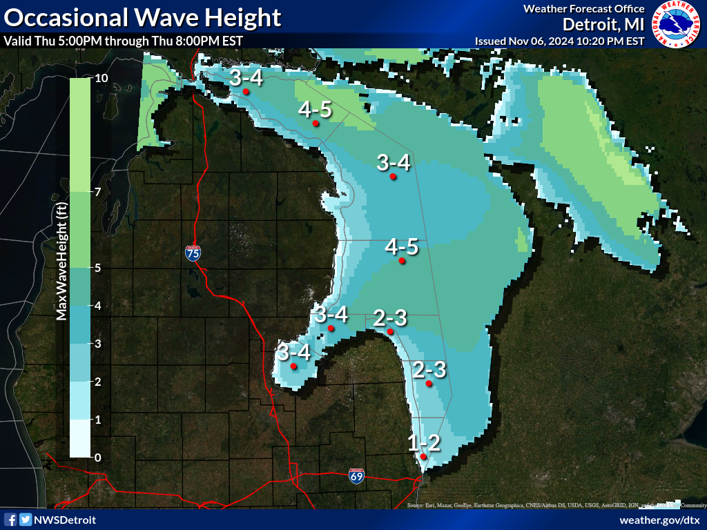
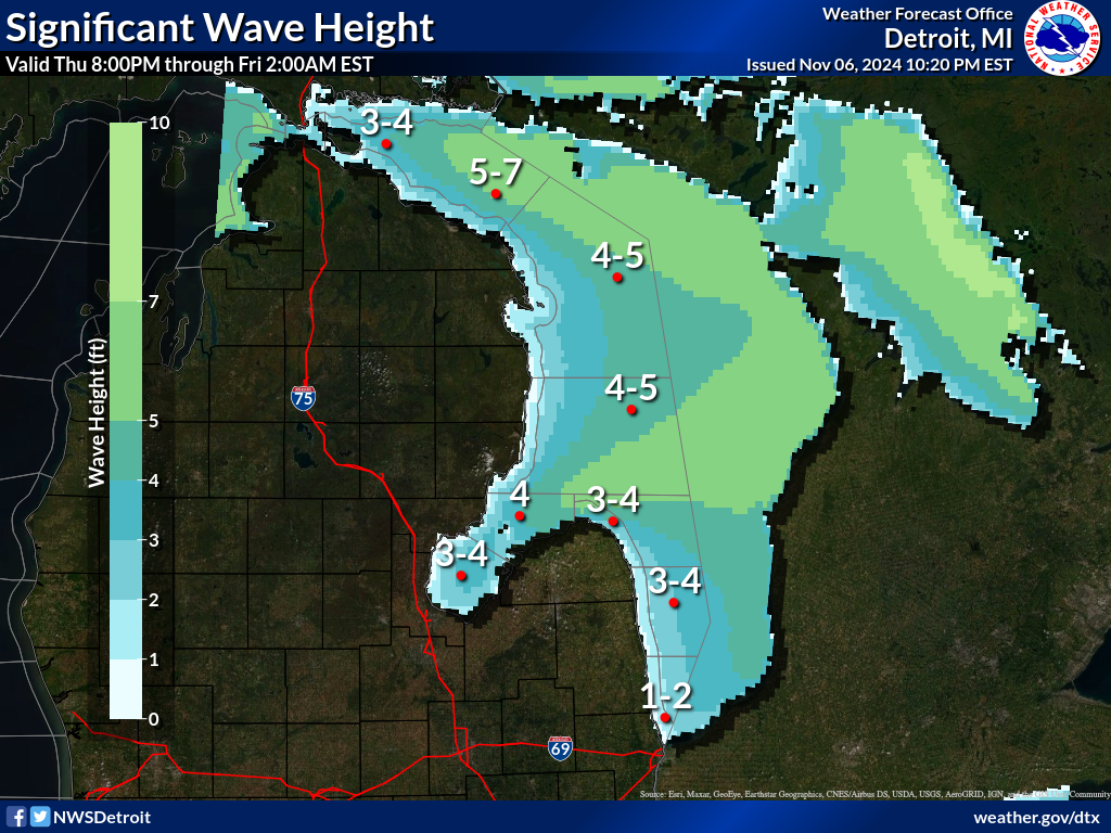
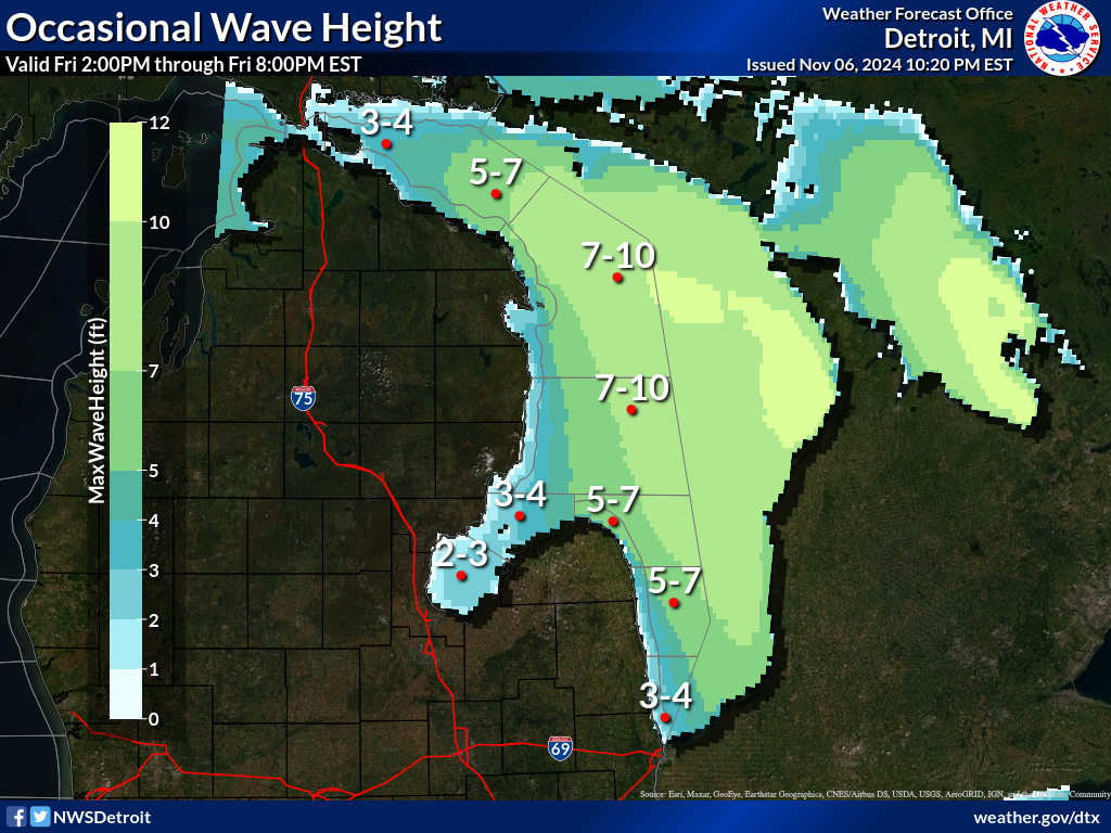
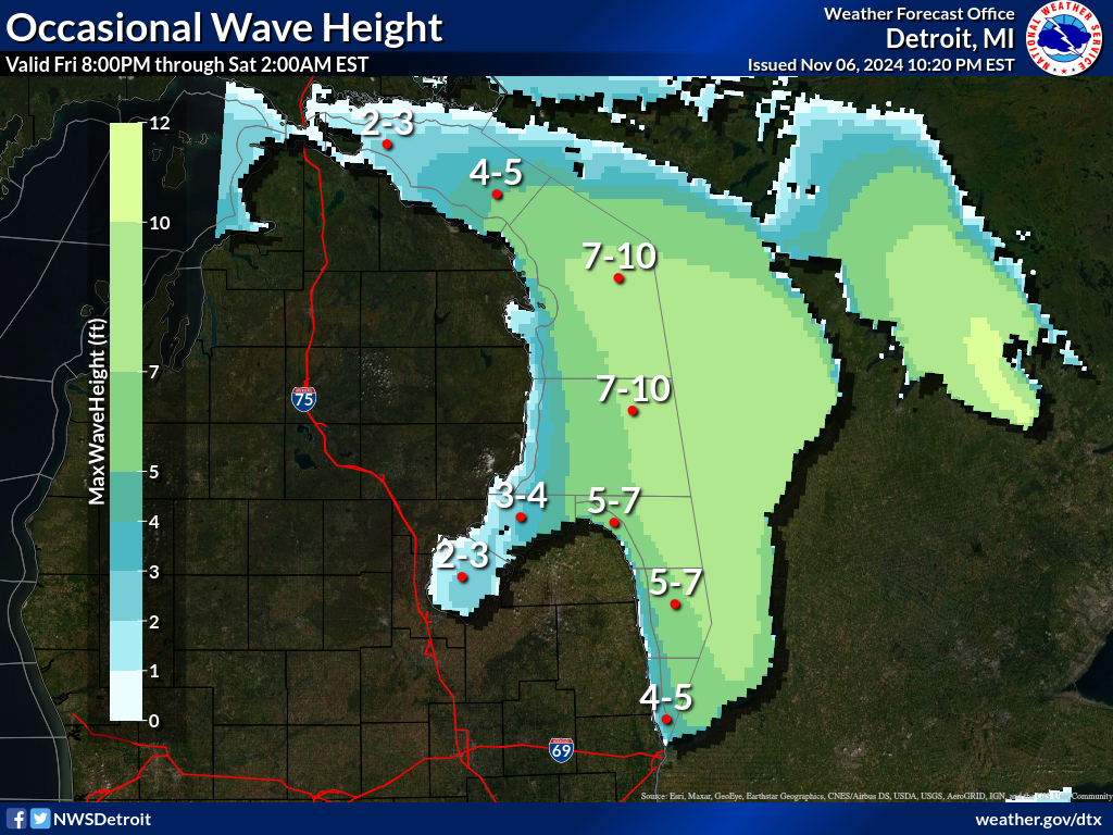
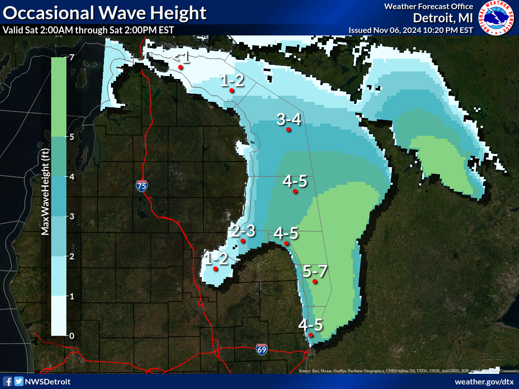
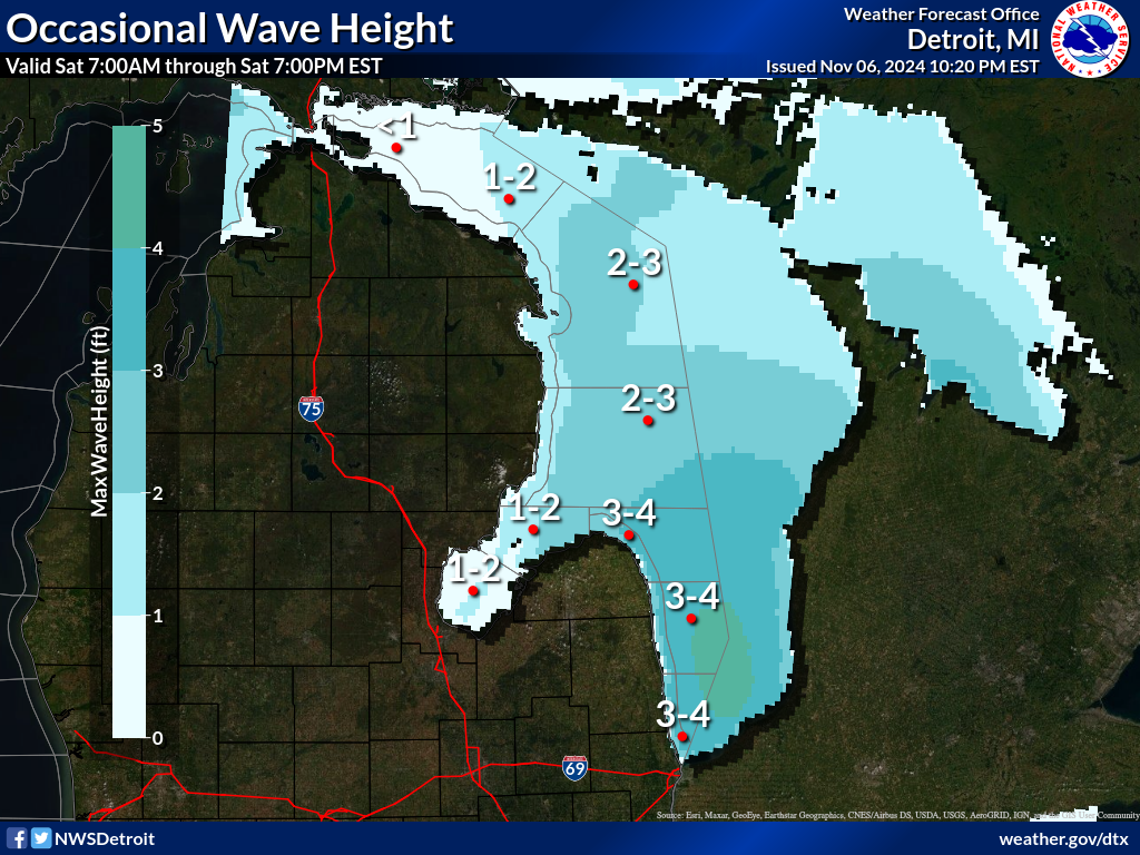
Waves are the significant wave height - the average of the highest
1/3 of the wave spectrum. Occasional wave height is the average of
the highest 1/10 of the wave spectrum.
.SYNOPSIS...High pressure, 30.20 inches, will hold over Iowa
today. A mainly dry cold front will drop south through the
Central Great Lakes tonight and Wednesday. Weak high pressure
follows for Thursday.
LHZ361-150345-
Lake Huron from 5NM east of Mackinac Bridge to Presque Isle Lt
beyond 5 NM off shore-
345 PM EDT Tue Jul 14 2026
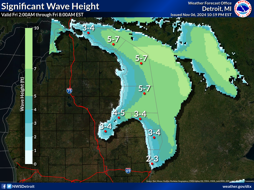
.TONIGHT...West winds 10 to 15 knots decreasing to 5 to 10 knots
after midnight. Waves 2 to 4 feet subsiding to 1 to 3 feet after
midnight.
.WEDNESDAY...Northwest winds 5 to 10 knots becoming west 10 to
15 knots late in the afternoon. Smoke. Waves 2 feet or less.
.WEDNESDAY NIGHT...Northwest winds 10 to 15 knots. Smoke in the
evening...then areas of smoke after midnight. Waves 2 to 4 feet.
.THURSDAY...West winds 10 to 15 knots. Smoke in the morning.
Waves 1 to 3 feet.
.THURSDAY NIGHT...West winds 10 to 15 knots becoming north 5 to
10 knots in the late evening and overnight. Waves 2 to 4 feet
subsiding to 1 to 3 feet in the late evening and overnight.
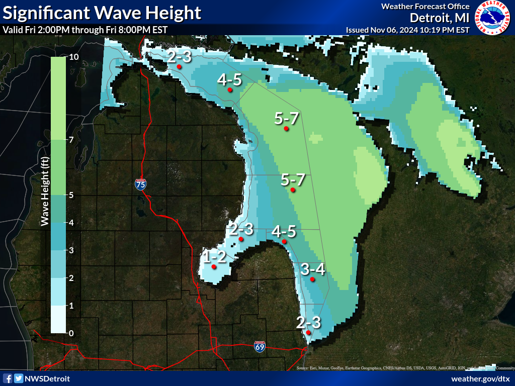
.FRIDAY...East winds 5 to 10 knots increasing to 10 to 15 knots
late in the morning...then decreasing to 5 to 10 knots late in
the afternoon. A chance of showers and thunderstorms late in the
afternoon. Rain showers likely late in the evening. Waves 1 to
3 feet.
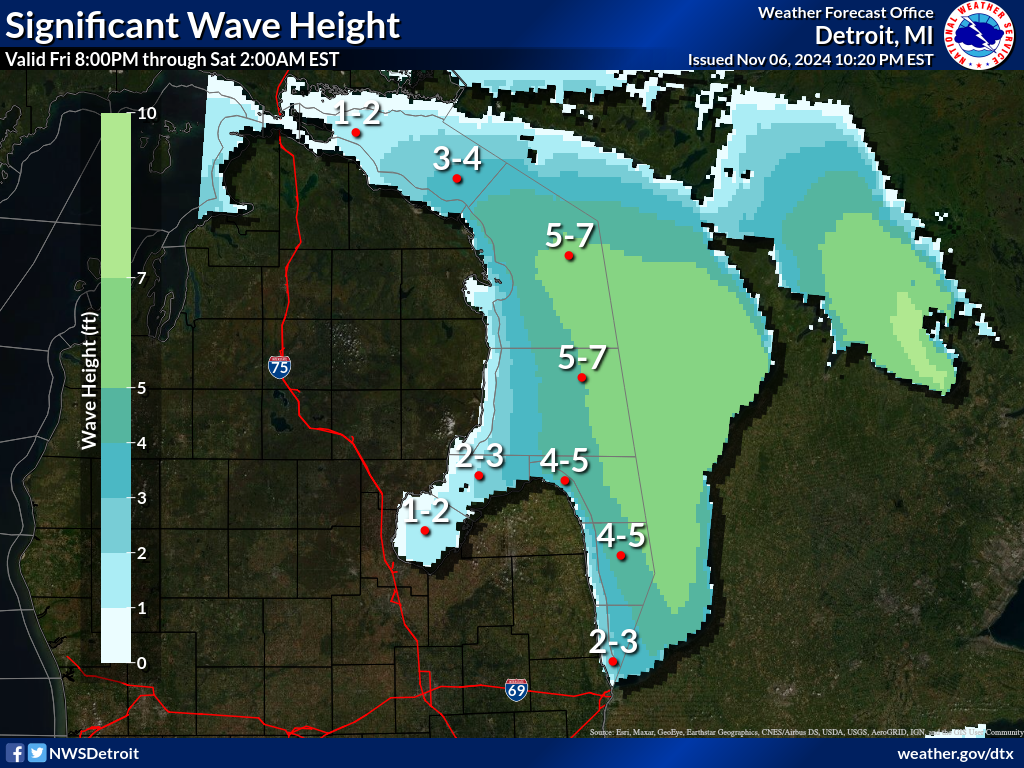
.SATURDAY...Southeast winds 5 to 10 knots increasing to 10 to
15 knots in the late morning and early afternoon...then backing
to the southeast 10 to 15 knots early in the evening decreasing
to 5 to 10 knots by midnight. Showers likely early in the
morning...then a chance of showers early in the evening. Waves
1 to 3 feet.
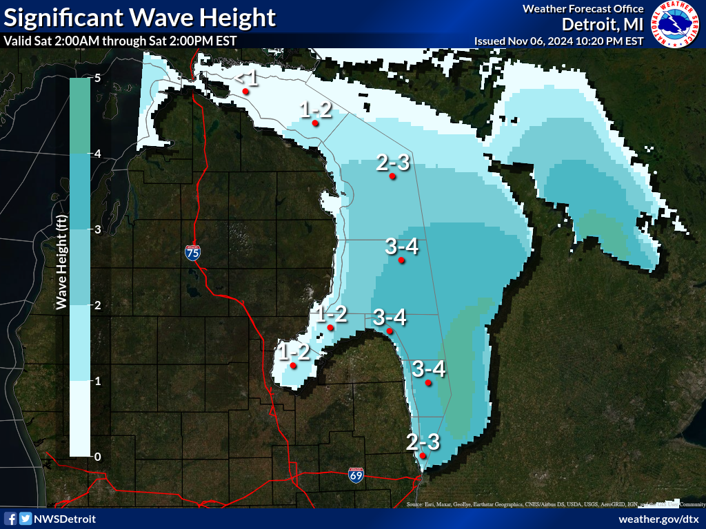
.SUNDAY...Northwest winds 5 to 10 knots backing to the west . A
chance of. Waves 2 feet or less.
$$
LHZ362-363-150345-
Lake Huron from Presque Isle Light to Sturgeon Point MI beyond
5NM off shore-
Lake Huron from Sturgeon Point to Alabaster MI beyond 5NM off
shore-
345 PM EDT Tue Jul 14 2026
.TONIGHT...West winds 5 to 10 knots. Waves 2 to 4 feet.
.WEDNESDAY...Northwest winds 5 to 10 knots. Smoke. Waves 1 to
3 feet.
.WEDNESDAY NIGHT...Northwest winds 10 to 15 knots. Smoke. Waves
3 to 5 feet.
.THURSDAY...Northwest winds 10 to 15 knots decreasing to 5 to
10 knots in the late morning and afternoon. Smoke in the morning.
Waves 2 to 4 feet subsiding to 1 to 3 feet in the late morning
and afternoon.
.THURSDAY NIGHT...Northwest winds 10 to 15 knots becoming north
5 to 10 knots in the late evening and overnight. Waves 2 to
4 feet subsiding to 1 to 3 feet after midnight.
.FRIDAY...East winds 5 to 10 knots. A chance of showers and
thunderstorms late in the afternoon. Rain showers likely and a
chance of thunderstorms late in the evening. Waves 2 feet or
less.
.SATURDAY...Southeast winds 5 to 10 knots becoming north 10 to
15 knots . Showers likely and a chance of thunderstorms...then a
chance of showers by midnight. Waves 1 to 3 feet.
.SUNDAY...North winds 5 to 10 knots until afternoon becoming
light and variable...then becoming southeast 5 to 10 knots by
midnight. Waves 2 feet or less.
$$
LHZ462>464-150345-
Lake Huron from Port Austin to Harbor Beach beyond 5NM Off Shore-
Lake Huron from Harbor Beach to Port Sanilac beyond 5NM Off Shore-
Lake Huron from Port Sanilac to Port Huron beyond 5NM Off Shore-
345 PM EDT Tue Jul 14 2026
.TONIGHT...West winds 10 to 15 knots decreasing to 5 to 10 knots
early in the morning. Waves 1 to 3 feet.
.WEDNESDAY...Northwest winds 5 to 10 knots early in the morning
becoming light and variable...then becoming north 5 to 10 knots
late in the afternoon. Patchy smoke in the morning...then smoke
in the afternoon. Waves 2 feet or less.
.WEDNESDAY NIGHT...Light and variable winds becoming north 5 to
10 knots in the late evening and overnight. Smoke. Waves 1 to
3 feet.
.THURSDAY...Northwest winds 5 to 10 knots. Smoke in the morning.
Waves 1 to 3 feet.
.THURSDAY NIGHT...Light and variable winds. Waves 2 feet or less.
.FRIDAY...Light and variable winds becoming east 5 to 10 knots. A
chance of showers late in the afternoon. Rain showers likely and
a chance of thunderstorms late in the evening. Waves 2 feet or
less.
.SATURDAY...South winds 5 to 10 knots becoming southwest 10 to
15 knots . Showers likely and a chance of thunderstorms...then a
chance of showers by midnight. Waves 1 to 3 feet.
.SUNDAY...North winds 10 to 15 knots decreasing to 5 to 10 knots.
Waves 1 to 3 feet.
$$
LHZ461-150345-
MAFOR 1421/
HURON NORTH 11610 12710 14700 11610. Waves 1 to 3 feet.
HURON SOUTH 11610 12600 14700 11800. Waves 1 to 3 feet.
$$
KGK
Experimental modernized open lake forecast is available online at
weather.gov/dtx/glftable (all lower case)
Graphical marine forecasts are available online at
weather.gov/greatlakes (all lower case)