Overview
A cold front stalled out in the vicinity of Flint during the afternoon provided a boundary between cooler northerly flow on the north side and warmer southwesterly flow on the south side. Temperatures were limited in the low-mid 70s with greater cloud coverage on the cool side and low 80s on the warm side with less cloud. SPC's Day 1 Severe Weather Outlook highlighted a Marginal to Slight risk and was followed up by a Severe Thunderstorm Watch at 522 PM EDT as the first round of storms entered Southeast Michigan.
A strong multicell moving east to west made landfall near Ludington around 3 PM EDT. This storm then tracked due east until it reached Mount Pleasant where it took a sharp turn toward the southeast. Shortly after, a large hail core materialized dropping hailstones that measured 2 inches in diameter (lime or hen egg sized) near Brant Township around 515 PM and 1.75 inch (golf ball sized) hail closer to Chesaning. The last severe hail report (1 inch) with this storm occurred just before Montrose at 545 PM. The storm weakened shortly afterwards near the Flint and Lapeer areas.
A trailing line of storms rolled ashore near Silver Lake around 615 PM with an eastward trajectory. These storms produced mainly damaging wind gusts as they approached the M-54 corridor around 745 PM. There were several reports of trees and power lines brought down as the storm tracked east along the I-69 corridor. Storms exited east into southern Ontario before 10 PM.
Radar
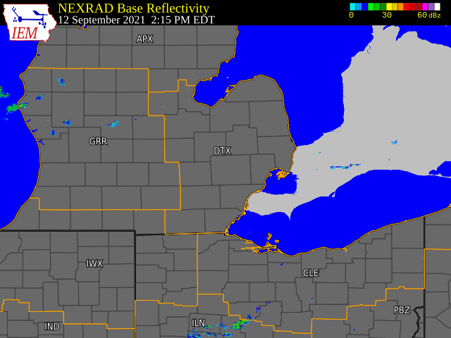  |
|
Click to Enlarge Radar loop courtesy of Iowa Environmental Mesonet (IEM) |
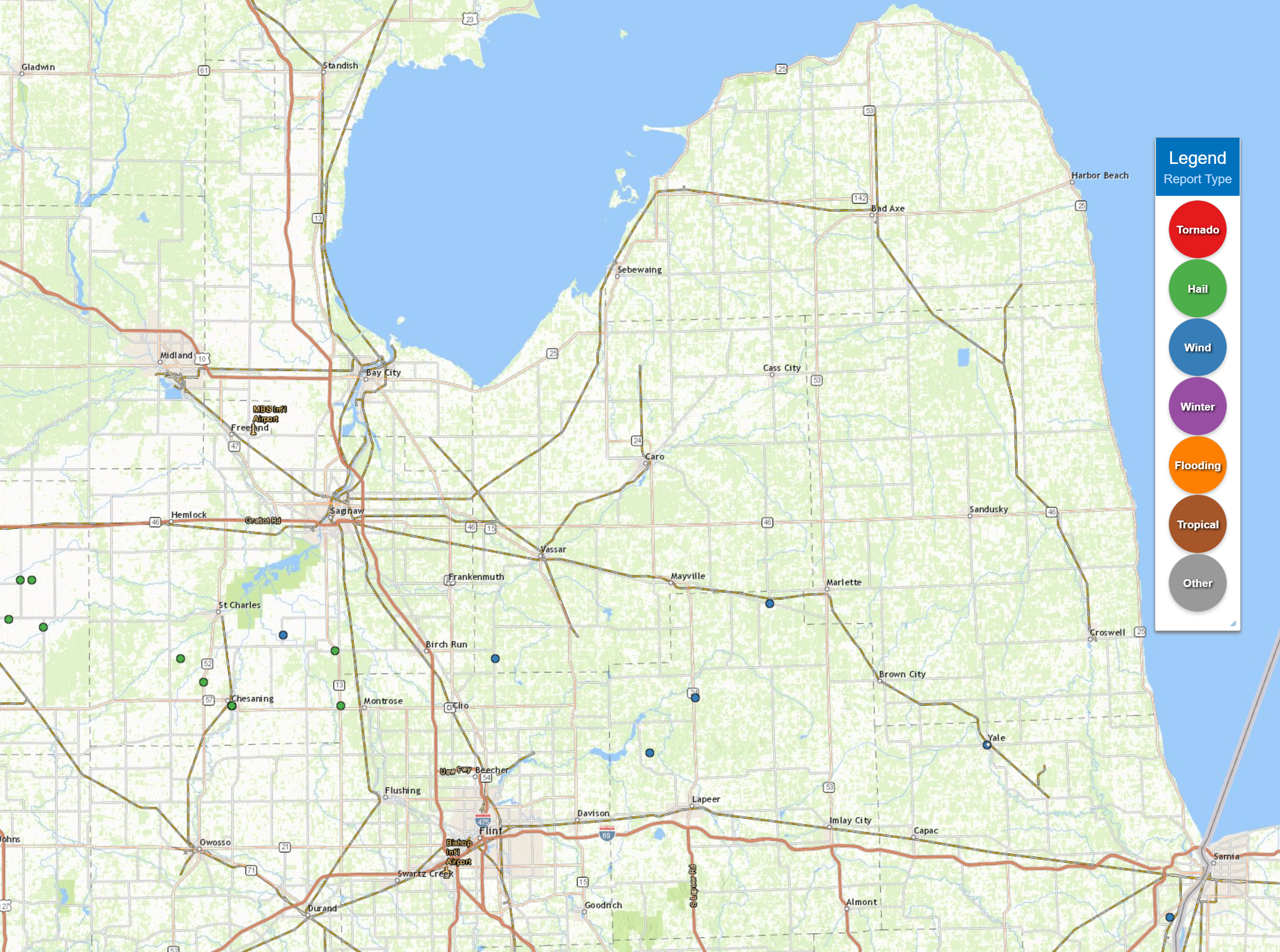
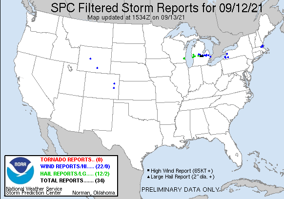
Storm Reports
|
|
|
Map of Local Storm Reports |
PRELIMINARY LOCAL STORM REPORT...SUMMARY
NATIONAL WEATHER SERVICE DETROIT/PONTIAC MI
933 AM EDT MON SEP 13 2021

..TIME...   ...EVENT...      ...CITY LOCATION...     ...LAT.LON...
..DATE...   ....MAG....      ..COUNTY LOCATION..ST.. ...SOURCE....
            ..REMARKS..

0522 PM     HAIL             5 SW ST. CHARLES        43.24N 84.21W
09/12/2021  E2.00 INCH       SAGINAW            MI   PUBLIC

            PUBLIC RELAYED SOCIAL MEDIA PHOTOS OF 2 INCH HAIL.

0534 PM     HAIL             3 NW CHESANING          43.21N 84.17W
09/12/2021  E1.75 INCH       SAGINAW            MI   PUBLIC

            PUBLIC RELAYED SOCIAL MEDIA PHOTOS OF ESTIMATED GOLF BALL
            SIZED HAIL.

0538 PM     HAIL             6 NNW MONTROSE          43.25N 83.94W
09/12/2021  E1.00 INCH       SAGINAW            MI   PUBLIC

            PUBLIC RELAYS VIDEO ON SOCIAL MEDIA OF ESTIMATED QUARTER
            SIZED HAIL.

0540 PM     HAIL             SSW CHESANING           43.18N 84.12W
09/12/2021  E1.75 INCH       SAGINAW            MI   FIRE DEPT/RESCUE

            GOLF BALL SIZED HAIL RELAYED BY FIRE DEPT/RESCUE.
            CONFIRMED BY PHOTOS.

0544 PM     HAIL             5 NNE NEW LOTHROP       43.18N 83.93W
09/12/2021  E1.00 INCH       GENESEE            MI   PUBLIC

            QUARTER SIZED HAIL REPORTED BY PUBLIC.

0611 PM     TSTM WND DMG     CLIFFORD                43.31N 83.18W
09/12/2021                   LAPEER             MI   911 CALL CENTER

            DISPATCH REPORTS POWER LINE DOWN IN CLIFFORD.

0745 PM     TSTM WND GST     5 S SHIAWASSEE NATIONAL 43.27N 84.03W
09/12/2021  M58.00 MPH       SAGINAW            MI   MESONET

            CORRECTED MAGNITUDE...OBSERVED VIA WEATHERFLOW STATION ON
            BISHOP RD IN ALICIA

0812 PM     TSTM WND DMG     CHESANING               43.18N 84.12W
09/12/2021                   SAGINAW            MI   911 CALL CENTER

            DISPATCH REPORTS TREES AND POWER LINES DOWN NEAR
            CHESANING.

0829 PM     TSTM WND DMG     6 NE CLIO               43.24N 83.66W
09/12/2021                   TUSCOLA            MI   911 CALL CENTER

            DISPATCH REPORTS TREES AND POWER LINES DOWN, MAINLY ALONG
            BRAY ROAD.

0842 PM     TSTM WND DMG     3 SSE COLUMBIAVILLE     43.12N 83.39W
09/12/2021                   LAPEER             MI   911 CALL CENTER

            DISPATCH REPORTS NUMEROUS TREES AND POWER LINES DOWN IN
            COLUMBIAVILLE VICINITY.

0844 PM     TSTM WND DMG     5 ENE COLUMBIAVILLE     43.19N 83.31W
09/12/2021                   LAPEER             MI   TRAINED SPOTTER

            TRAINED SPOTTER REPORTS LARGE TREE LIMBS BLOCKING LANES
            AT INTERSECTION OF COLUMBIAVILLE RD AND M-24.

0912 PM     TSTM WND DMG     YALE                    43.13N 82.80W
09/12/2021                   ST. CLAIR          MI   911 CALL CENTER

            DISPATCH REPORTS NUMEROUS TREES AND POWER LINES DOWN IN
            YALE.

0924 PM     TSTM WND DMG     MARYSVILLE              42.91N 82.48W
09/12/2021                   ST. CLAIR          MI   911 CALL CENTER

            DISPATCH REPORTS NUMEROUS TREES AND POWER LINES DOWN IN
            THE MARYSVILLE VICINITY.
 |
|
National Storm Reports for September 12, 2021 |
Environment
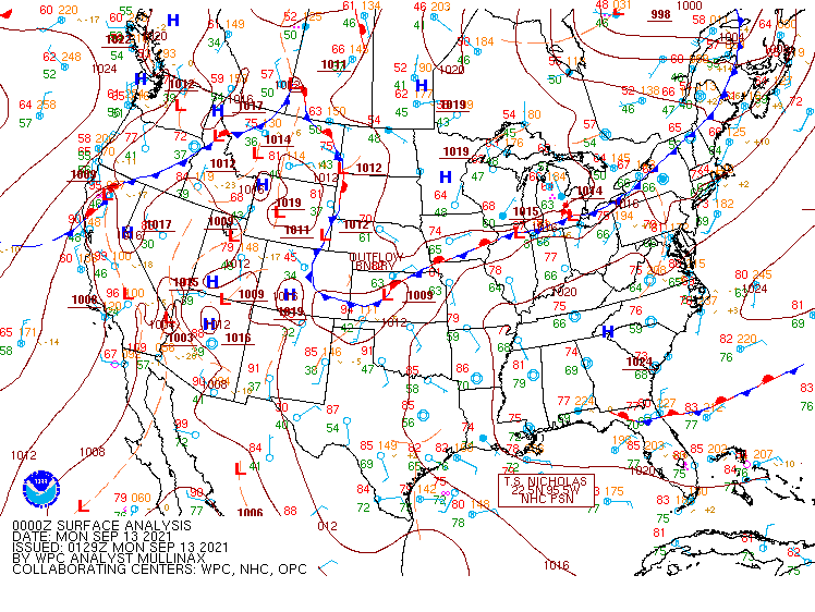
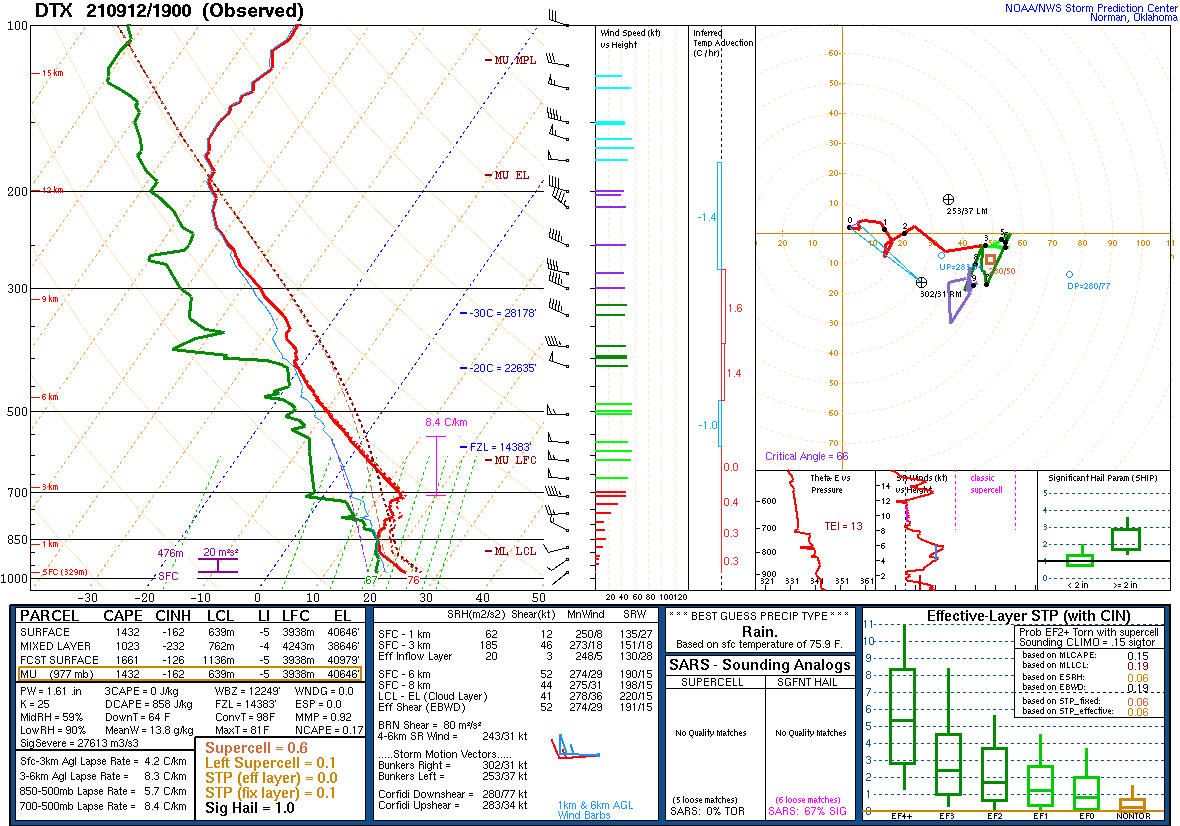
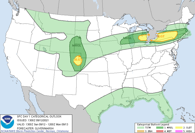
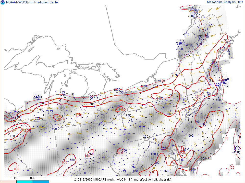
Fixated dynamic upper level pattern situated across the Midwest helped ensure a strong shear environment with EBS values of 45-55 knots (Figure 7). At the surface, a cold front was decelerating over southern Lower ensuring a modest baroclinic zone as the boundary became stationary by early evening (Figure 1-2). Formidable temperature and moisture gradient resided along the convergence axis acting as corridor for downstream enhancement. Major question regarding the pre-environment setup given very strong capping inversion near 800 mb per the 12Z KDTX RAOB (Figure 3). A special 19Z release was conducted revealing a sustained cap, just a little higher up near 700 mb (Figure 4). With the re-confirmed cap in place, any convection that survived into the Saginaw Valley was expected to remain elevated in nature. Plenty of instability resided aloft within the Elevated Mixed Layer (EML) with pockets of +1000 J/kg of MUCAPE, and even greater magnitudes south of the frontal zone. SPC did maintain the Slight Risk for the north and a Marginal risk further south with the 13Z and 1630Z outlooks (Figure 5).
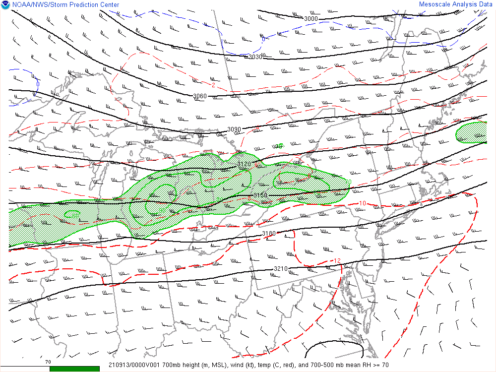
As the first storm approached along a transiting mid level shortwave (Figure 8), the strong capping inversion limited the wind threat. Accordingly, just few reports of severe wind damage were received. However, given the steep mid level lapse rates in place (Figures 6 & 9), ample instability aloft was able to generate large hail with several hailstones near 2 inches in diameter across Shiawassee County. Max 2-6 km lapse rates peaked between 8-9 C/km (Figure 6) and MUCAPEs were realized as the storm turned southeast into the instability gradient.
Although the storm did not maintain full strength east of I-75 and through the northern suburbs, it did erode most of the stable layer. This allowed the second round of convection to mix down strong gusts resulting in severe thunderstorm wind damage north of the I-69 corridor during the late evening.
Click on the images below to see them expanded.
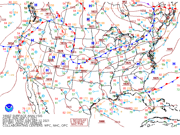 |
 |
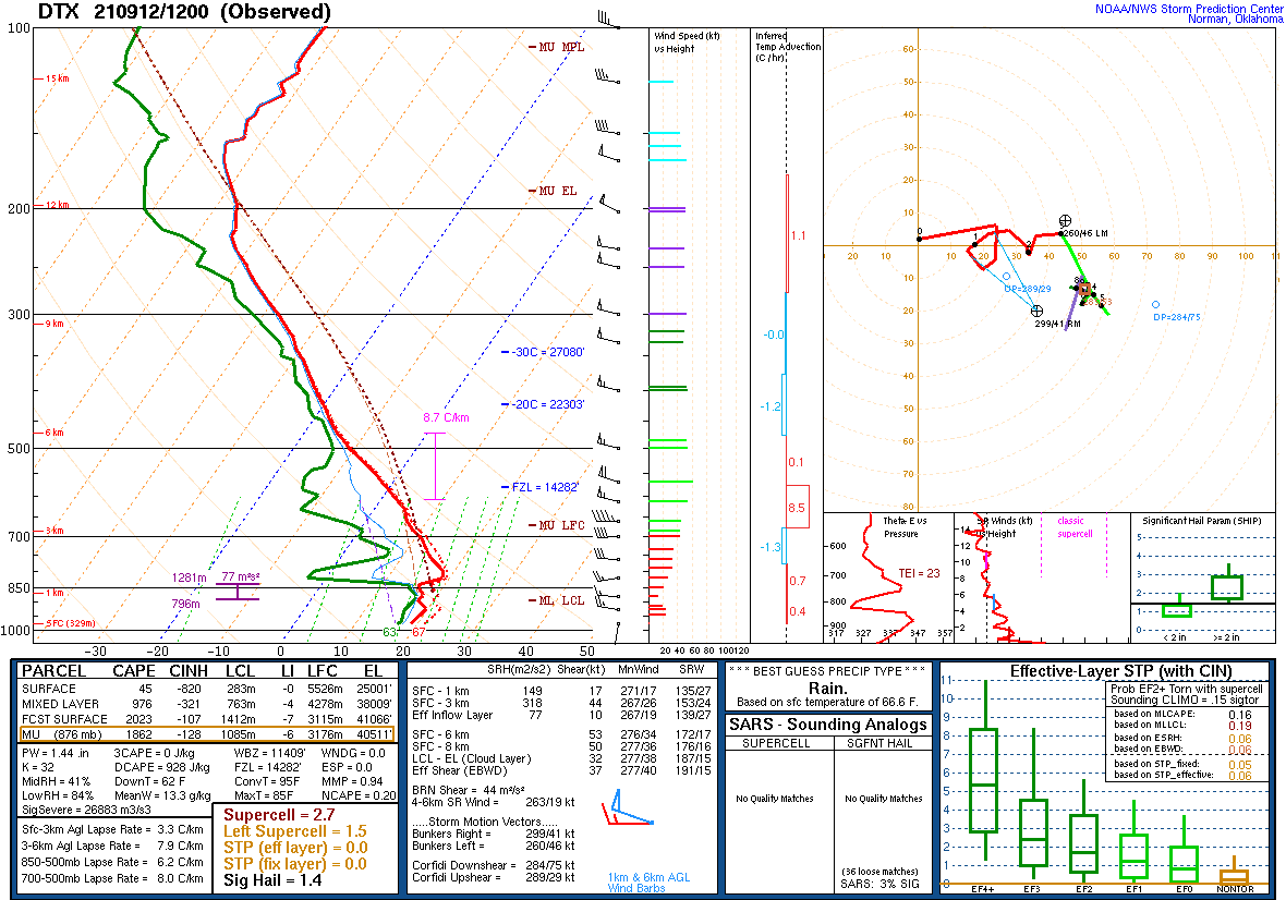 |
| Figure 1: Weather Prediction Center (WPC) surface map, valid 18 UTC 12 Sep 2021. | Figure 2: Weather Prediction Center (WPC) surface map, valid 00 UTC 13 Sep 2021. | Figure 3: KDTX observed sounding, valid 12 UTC 12 Sep 2021. |
 |
 |
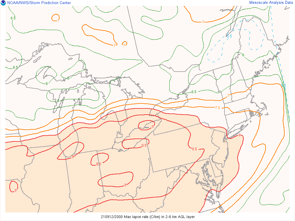 |
| Figure 4: KDTX observed sounding, valid 19 UTC 12 Sep 2021. | Figure 5: SPC Day 1 Outlook, valid 13 UTC 12 Sep 2021. | Figure 6: 2-6 km AGL layer max lapse rates valid 20 UTC 12 Sep 2021. |
 |
 |
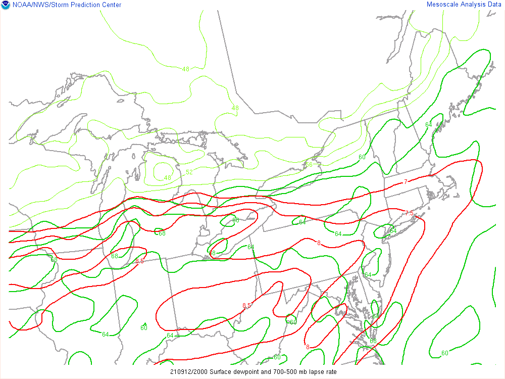 |
| Figure 7: EBS, MUCAPE, and MUCIN, valid 20 UTC 12 Sep 2021. | Figure 8: 700 mb Height, Wind, Temp, RH, valid 00 UTC 13 Sep 2021. | Figure 9: Surface dewpoint and 700-500 mb Lapse Rate, valid 20 UTC 12 Sep 2021. |
 |
Media use of NWS Web News Stories is encouraged! Please acknowledge the NWS as the source of any news information accessed from this site. |
|