Overview
Scattered severe thunderstorms developed on the afternoon of September 13, 2019 and moved quickly northeast across much of Southeast Michigan. A warm front passed through during the morning and brought an increasingly unstable air mass, while strong winds aloft provided enough wind shear for storm organization and several supercells. The associated cold front pushed through during the evening and ushered the storms out of the area. Numerous reports of wind damage across the area were received as well as reports of large hail from southwest Oakland County.
Photos
 |
 |
 |
|
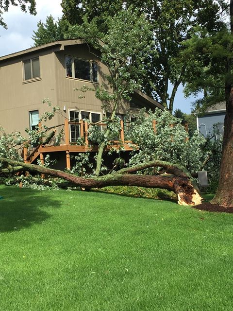
Novi Credit: Cody Reynolds |
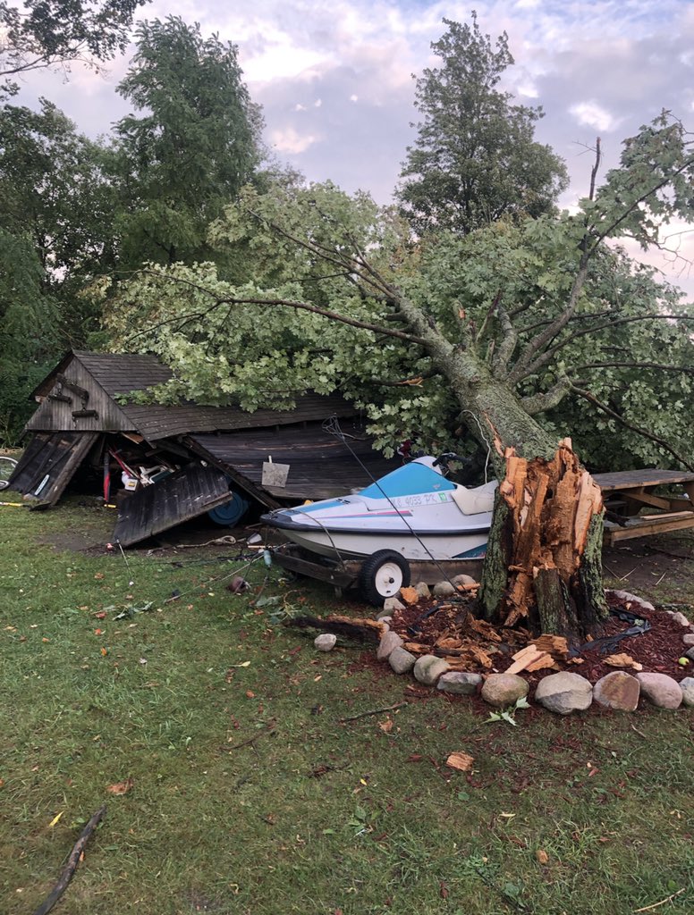
New Hudson Credit: Ryan Perry |
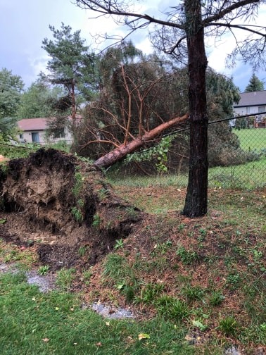
Wolverine Lake Credit: Nolan Waters |
 |
 |
 |
|
Lake Orion Credit: Ben Redmon |
Raisinville Township Credit: Ryan Harriott |
Forester Credit: Michael Saylor |
 |
 |
 |
|
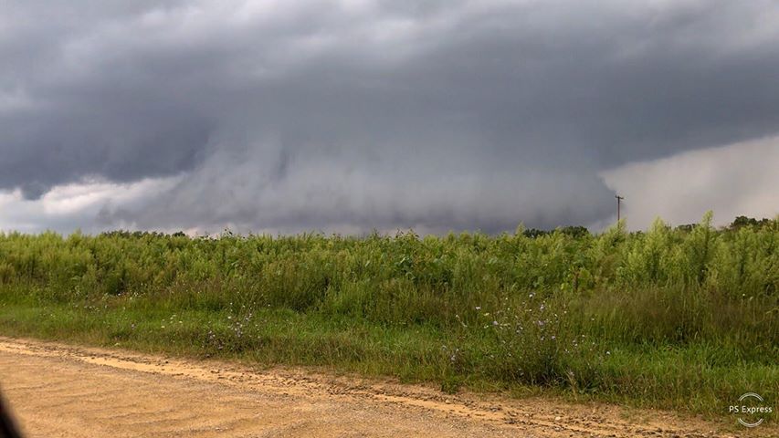
Near Davison Credit: Matt Daniels |
South Lyon Credit: Nicole Mundinger |
Wixom Credit: Jeff Winters |
Radar
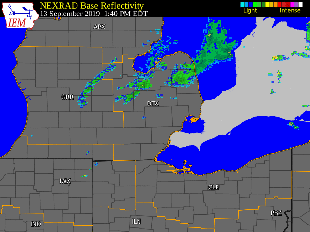  |
|
Click to Enlarge Radar loop courtesy of Iowa Environmental Mesonet (IEM) |
Storm Reports
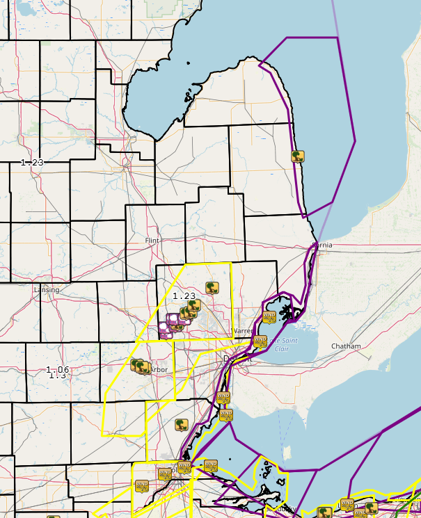

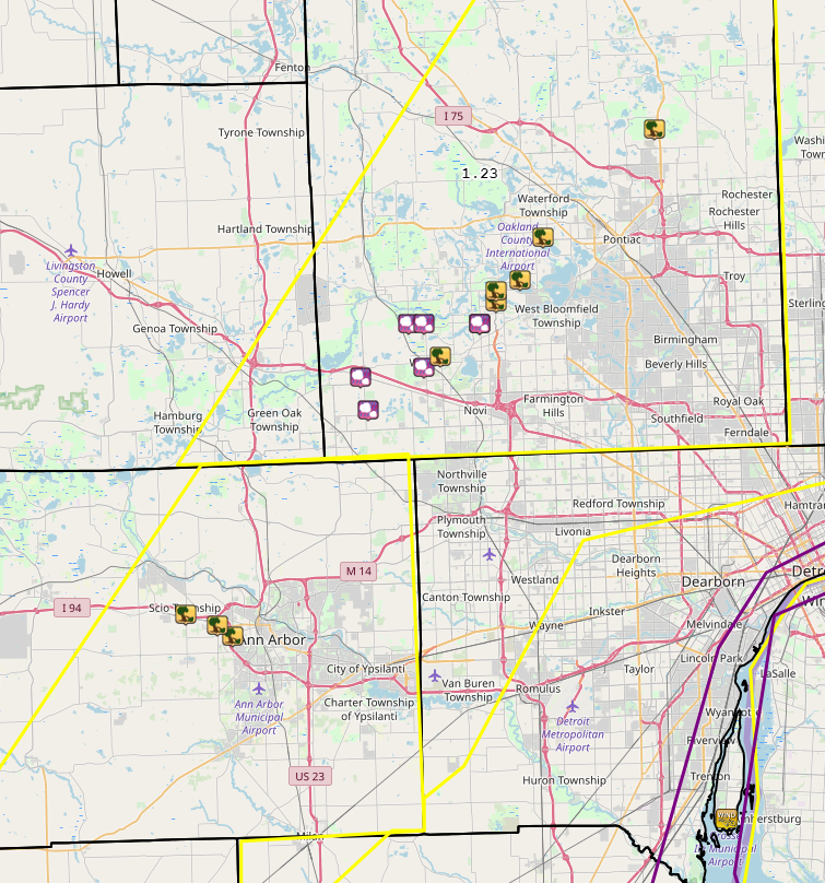
Map of Severe Thunderstorm Warnings (yellow), Special Marine Warnings (purple), thunderstorm wind damage and hail reports, and heavy rainfall reports (number values).
Detail on Oakland and Washtenaw Counties:
Severe Weather Local Storm Reports:
PRELIMINARY LOCAL STORM REPORT...SUMMARY
NATIONAL WEATHER SERVICE DETROIT/PONTIAC MI
852 PM EDT FRI SEP 13 2019

..TIME...   ...EVENT...      ...CITY LOCATION...     ...LAT.LON...
..DATE...   ....MAG....      ..COUNTY LOCATION..ST.. ...SOURCE....
            ..REMARKS..

0304 PM     TSTM WND DMG     3 WSW ANN ARBOR         42.27N 83.78W
09/13/2019                   WASHTENAW          MI   PUBLIC

            TREE DOWN AT PAULINE BLVD AND SOUTH MAPLE RD.

0304 PM     TSTM WND DMG     6 WNW ANN ARBOR         42.29N 83.84W
09/13/2019                   WASHTENAW          MI   911 CALL CENTER

            DISPATCH REPORTS A TREE DOWN AT I-94 AND ZEEB RD,
            BLOCKING ONE LANE.

0305 PM     TSTM WND DMG     4 W ANN ARBOR           42.28N 83.80W
09/13/2019                   WASHTENAW          MI   PUBLIC

            TREES DOWN ON JACKSON AVE WEST OF WAGNER RD.

0324 PM     HAIL             2 ENE SOUTH LYON        42.48N 83.61W
09/13/2019  E1.25 INCH       OAKLAND            MI   PUBLIC

            REPORTED NEAR 11 MILE AND MILFORD RDS.

0328 PM     HAIL             NEW HUDSON              42.51N 83.62W
09/13/2019  E1.75 INCH       OAKLAND            MI   PUBLIC

0330 PM     HAIL             5 SE MILFORD            42.52N 83.54W
09/13/2019  M1.75 INCH       OAKLAND            MI   TRAINED SPOTTER

            GOLF BALL SIZE HAIL REPORTED NEAR WIXOM RD AND PONTIAC
            TRAIL.

0331 PM     TSTM WND DMG     4 NNW NOVI              42.53N 83.52W
09/13/2019                   OAKLAND            MI   TRAINED SPOTTER

            TWO LARGE PINE TREES UPROOTED NEAR PONTIAC TRAIL AND BECK
            RD.

0334 PM     HAIL             4 ESE MILFORD           42.56N 83.54W
09/13/2019  E1.75 INCH       OAKLAND            MI   PUBLIC

            SLIGHTLY LARGER THAN GOLF BALL SIZE HAIL REPORTED NEAR
            WIXOM AND GLENGARY RDS.

0334 PM     HAIL             3 SE MILFORD            42.56N 83.56W
09/13/2019  M1.50 INCH       OAKLAND            MI   PUBLIC

            REPORTED NEAR CHARMS AND WIXOM RDS.

0335 PM     TSTM WND DMG     3 W WEST BLOOMFIELD     42.58N 83.45W
09/13/2019                   OAKLAND            MI   NWS EMPLOYEE

            LARGE TREE DOWN ACROSS THE ROAD AT UNION LAKE AND
            RICHARDSON RDS.

0335 PM     HAIL             5 W WEST BLOOMFIELD     42.56N 83.47W
09/13/2019  M1.00 INCH       OAKLAND            MI   TRAINED SPOTTER

            NEAR GLENGARY AND S COMMERCE RDS.

0335 PM     TSTM WND DMG     5 W WEST BLOOMFIELD     42.56N 83.47W
09/13/2019                   OAKLAND            MI   TRAINED SPOTTER

            LARGE TREE LIMB DOWN NEAR GLENGARY AND S COMMERCE RDS.

0337 PM     TSTM WND DMG     4 WNW WEST BLOOMFIELD   42.59N 83.45W
09/13/2019                   OAKLAND            MI   NWS EMPLOYEE

            TREE DOWN BLOCKING COMMERCE RD.

0339 PM     TSTM WND DMG     3 NW WEST BLOOMFIELD    42.60N 83.42W
09/13/2019                   OAKLAND            MI   PUBLIC

            NUMEROUS TREES REPORTED DOWN ON WILLOW RD BETWEEN KEITH
            AND LOCHAVEN RDS.

0345 PM     TSTM WND DMG     5 W PONTIAC             42.64N 83.39W
09/13/2019                   OAKLAND            MI   TRAINED SPOTTER

            MULTIPLE 8 TO 12 INCH DIAMETER TREES DOWN AT INTERSECTION
            OF CRESCENT LAKE AND ELIZABETH LAKE RDS.

0355 PM     TSTM WND DMG     3 S LAKE ORION          42.74N 83.25W
09/13/2019                   OAKLAND            MI   PUBLIC

            SEVERAL TREES DOWNED NEAR WALDON RD AND M-24.

0411 PM     TSTM WND DMG     6 WNW MONROE            41.94N 83.49W
09/13/2019                   MONROE             MI   PUBLIC

            DAMAGE TO BARN AND TREE DOWN NEAR M-50 AND STRASBURG RD.

0419 PM     MARINE TSTM WIND 6 E FLAT ROCK           42.10N 83.16W
09/13/2019  M45.00 MPH       WAYNE              MI   AWOS

            MEASURED AT GROSSE ILE AIRPORT KONZ.

0435 PM     MARINE TSTM WIND 5 E ESTRAL BEACH        42.00N 83.14W
09/13/2019  M72.00 MPH       LEZ444             MI   MESONET

            MEASURED AT DETROIT RIVER LIGHT.

0515 PM     MARINE TSTM WIND 4 NNE GROSSE POINTE     42.43N 82.87W
09/13/2019  M39.00 MPH       LCZ460             MI   MESONET

            MEASURED AT GROSSE POINTE YACHT CLUB.

0518 PM     TSTM WND DMG     5 NNW PORT SANILAC      43.50N 82.57W
09/13/2019                   SANILAC            MI   TRAINED SPOTTER

            NUMEROUS TREES DOWN AND DAMAGE TO A PAVILION NEAR
            FORESTER RD AND M-25.

0534 PM     MARINE TSTM WIND 5 ESE MOUNT CLEMENS     42.57N 82.80W
09/13/2019  M44.00 MPH       MACOMB             MI   MESONET

            MEASURED AT LAKE ST. CLAIR METROPARK.

0535 PM     HEAVY RAIN       4 SW CLARKSTON          42.70N 83.47W
09/13/2019  M1.23 INCH       OAKLAND            MI   OFFICIAL NWS OBS

            2 HOUR RAINFALL TOTAL MEASURED AT NWS OFFICE IN WHITE
            LAKE.
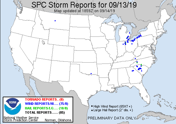
National Storm Reports:
Environment
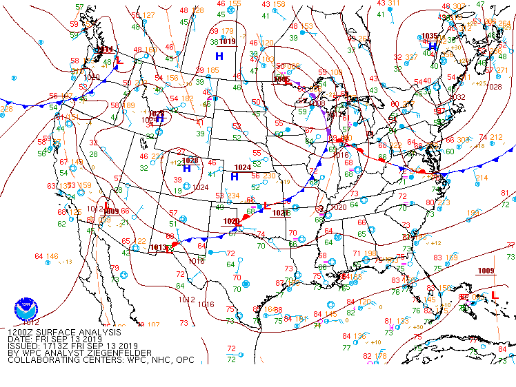
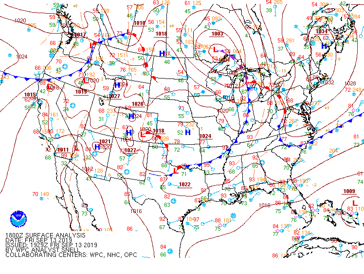
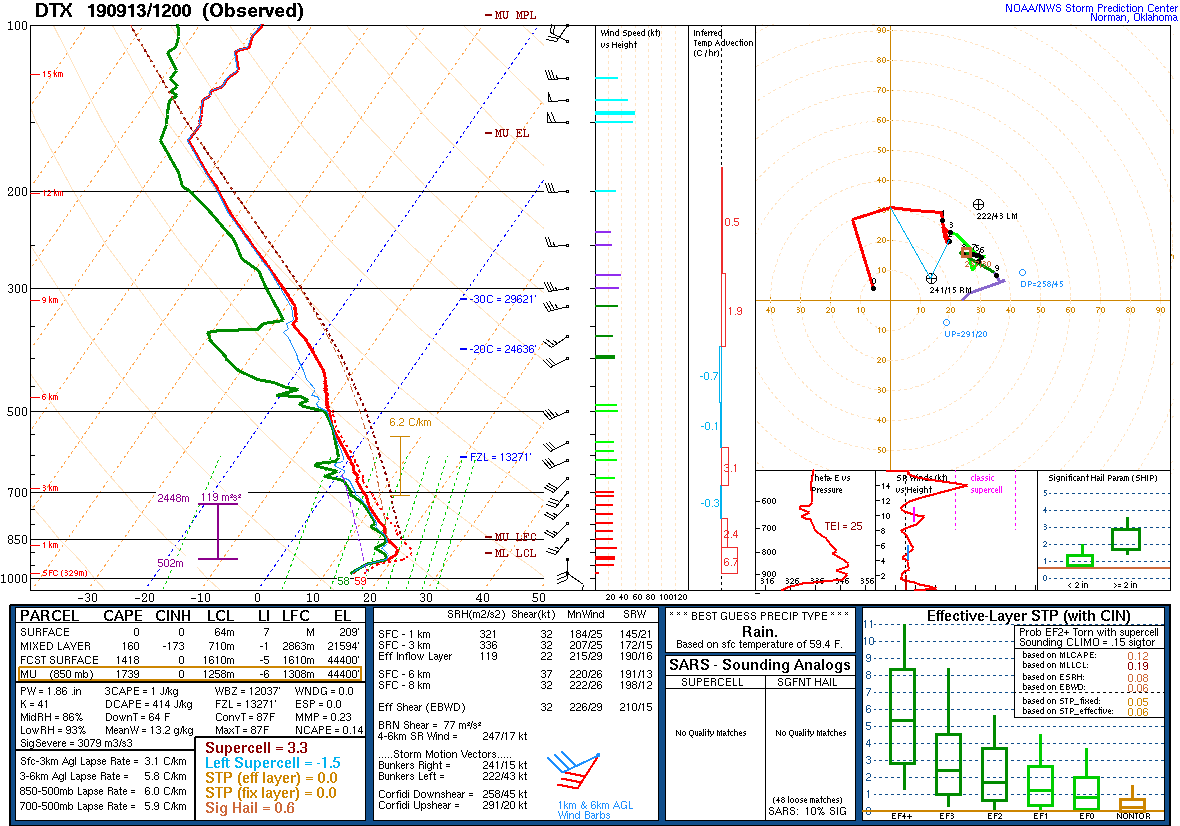
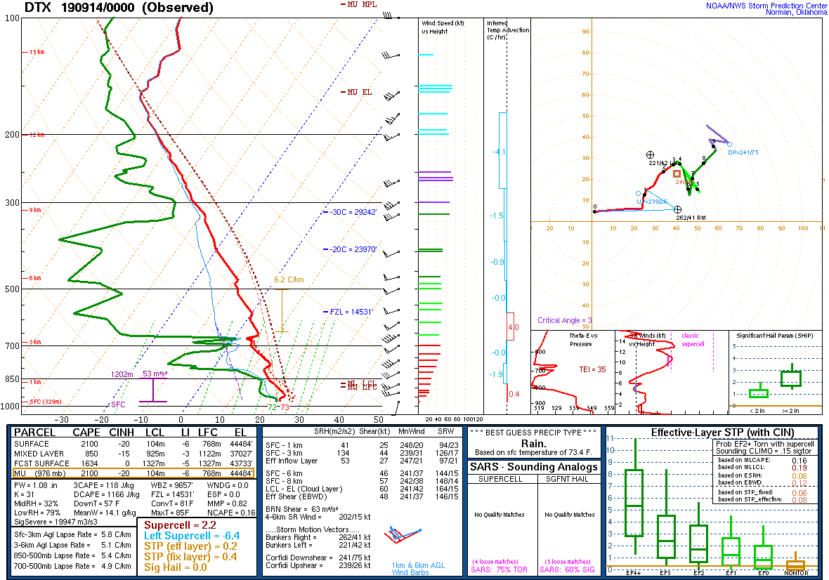
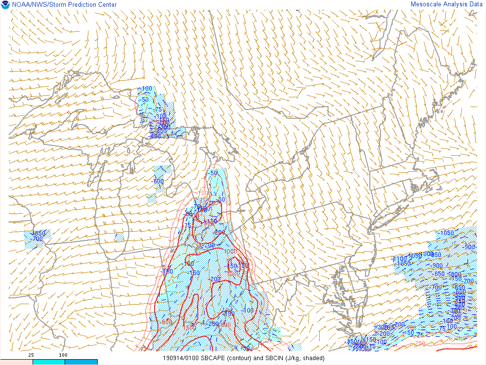
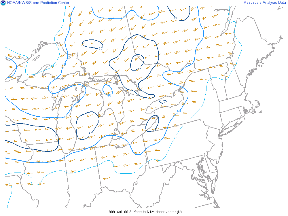
September 13th was the final round of storms for an active second week of September. A line of showers and storms moved across western Michigan during the morning hours bringing moderate rainfall to the Saginaw Bay and northern Thumb areas. These storms fizzled as the morning progressed allowing for clearing skies in the late morning and early afternoon hours. During this same time frame, a warm front pushed up through the region bringing a relatively hot, humid airmass for this time of year. With temperatures in the mid-80's for the metro area (with low 80s in the Thumb and low 90s closer to the Ohio border) and dew points in the low 70s, this brought in very unstable air that would later fuel storms (see Figure 6). CAPE values generally hovered around 2000 J/kg with a bubble of 3000 J/kg in the southern counties. Co-located was a tongue of higher low-level lapse rates of around 7.5 C/km (see Figure 8). Bulk shear was high enough to support thunderstorm development and in particular supercell development (see Figure 7). All these ingredients came together ahead of a cold front which allowed for strong to severe wind gusts to reach the surface as well as strong updrafts to support hail growth. Washtenaw, Wayne, Monroe, and particularly Oakland County, would see some of the strongest storms with golfball-size hail and the most wind damage reports. Strong thunderstorms were still seen over the rest of the area bringing some much needed rain, especially in the Thumb area.
 |
 |
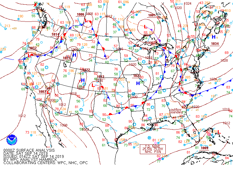 |
| Figure 1: Surface map, valid 12 UTC September 13, 2019. | Figure 2: Surface map, valid 18 UTC September 13, 2019. | Figure 3: Surface map, valid 00 UTC September 13, 2019. |
 |
 |
|
| Figure 4: DTX upper air sounding, valid 12 UTC September 13, 2019. | Figure 5: DTX upper air sounding, valid 00 UTC September 14, 2019. Note: This sounding was taken after storms had moved through. | |
 |
 |
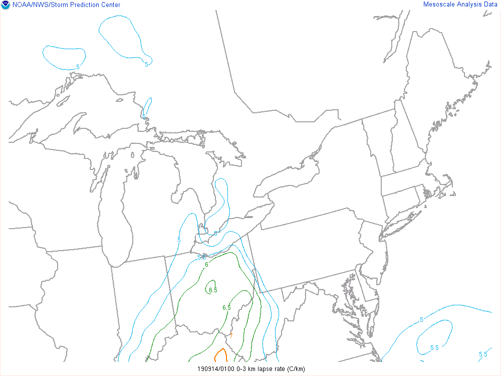 |
| Figure 6: Loop of surface-based Convective Available Potential Energy (CAPE), valid from 15 UTC September 13, 2019 to 01 UTC September 14, 2019. | Figure 7: Loop of Bulk 0-6km wind shear, valid from 15 UTC September 13, 2019 to 01 UTC September 14, 2019. | Figure 8: Loop of 0-3km Low-level Lapse Rates, valid from 15 UTC September 13, 2019 to 01 UTC September 14, 2019. |
 |
Media use of NWS Web News Stories is encouraged! Please acknowledge the NWS as the source of any news information accessed from this site. |
|

