Overview
In the morning remnant storms from Wisconsin the prior afternoon moved across the Tri-Cities and Thumb area with showers over the north Metro area. A hot, humid airmass was settled over the state and provided the instability across southern Michigan for numerous strong thunderstorms. Storms mainly produced severe wind gusts up to 60 mph, particularly along the I-96 corridor southeast from southern Shiawassee/northern Livingston to the coast of Lake St. Clair in southern Macomb/northern Wayne counties and east along the Washtenaw-Lenawee and Wayne-Monroe county lines. Some hail up to 1 inch was reported near the Livingston-Washtenaw county line. The severe wind gusts caused widespread tree damage and power outages.
Photos
 |
 |
|
|
Redford Credit: Ron Hilliard |
Oxford Credit: Josh Matthews |
|
 |
 |
|
|
I-75 near Bay City Credit: Lisa Banks |
Birmingham Credit: Katy Pitstick |
Radar
  |
|
Click to Enlarge Radar loop courtesy of Iowa Environmental Mesonet (IEM) |
Storm Reports
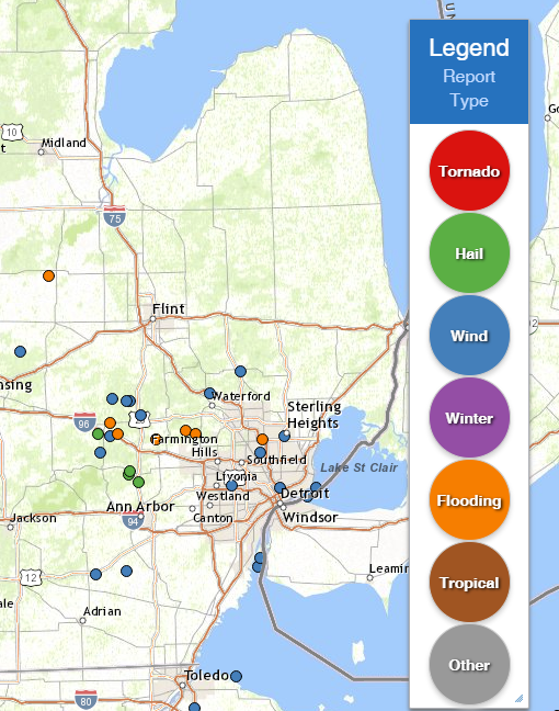
Map of Local Storm Reports Depicting Hail to 1/2 inch or greater (green), damaging wind gusts (blue), and heavy rainfall greater than 1" (orange):
----------------------------------------------------------------------------------------------------
Severe Weather Local Storm Reports:
PRELIMINARY LOCAL STORM REPORT...SUMMARY
NATIONAL WEATHER SERVICE DETROIT/PONTIAC MI
1143 AM EDT WED JUL 3 2019

..TIME...   ...EVENT...      ...CITY LOCATION...     ...LAT.LON...
..DATE...   ....MAG....      ..COUNTY LOCATION..ST.. ...SOURCE....
            ..REMARKS..

0432 PM     TSTM WND DMG     3 ENE MACON             42.08N 83.82W
07/02/2019                   WASHTENAW          MI   PUBLIC

            SEVERAL TREES REPORTED DOWNED EAST OF THE HACK RD AND
            MACON RD INTERSECTION.

0456 PM     TSTM WND DMG     5 N PINCKNEY            42.52N 83.95W
07/02/2019                   LIVINGSTON         MI   NWS EMPLOYEE

            MULTIPLE LARGE TREES DOWNED.

0509 PM     TSTM WND DMG     4 NW HARTLAND           42.71N 83.80W
07/02/2019                   LIVINGSTON         MI   PUBLIC

            DOWNED TREES AND WIRES. TIME ESTIMATED VIA RADAR.

0518 PM     HAIL             HAMBURG                 42.45N 83.80W
07/02/2019  M1.25 INCH       LIVINGSTON         MI   PUBLIC

            TIME ESTIMATED VIA RADAR.

0518 PM     HAIL             1 SW HAMBURG            42.44N 83.81W
07/02/2019  M1.00 INCH       LIVINGSTON         MI   PUBLIC

0526 PM     HAIL             2 SSW WHITMORE LAKE     42.41N 83.76W
07/02/2019  M1.00 INCH       WASHTENAW          MI   TRAINED SPOTTER

            TIME ESTIMATED VIA RADAR.

0537 PM     MARINE TSTM WIND 6 E FLAT ROCK           42.10N 83.16W
07/02/2019  M41.00 MPH       WAYNE              MI   AWOS

            MEASURED AT GROSSE ILE MUNICIPAL AIRPORT.

0537 PM     TSTM WND DMG     GROSSE ILE              42.13N 83.15W
07/02/2019                   WAYNE              MI   PUBLIC

            DOWNED TREES. TIME ESTIMATED VIA RADAR.

0538 PM     TSTM WND DMG     1 E CLARKSTON           42.74N 83.40W
07/02/2019                   OAKLAND            MI   PUBLIC

            DOWNED TREES. TIME ESTIMATED VIA RADAR.

0555 PM     MARINE TSTM WIND 6 E FLAT ROCK           42.10N 83.16W
07/02/2019  M46.00 MPH       WAYNE              MI   AWOS

            MEASURED AT GROSSE ILE MUNICIPAL AIRPORT

0625 PM     TSTM WND DMG     STERLING HEIGHTS        42.58N 83.03W
07/02/2019                   MACOMB             MI   PUBLIC

            DOWNED TREES. TIME ESTIMATED VIA RADAR.

0645 PM     TSTM WND DMG     2 ENE OAK GROVE         42.72N 83.89W
07/02/2019                   LIVINGSTON         MI   PUBLIC

            MULTIPLE LARGE TREES DOWN ACROSS GREEN AND DEAN ROADS.

0645 PM     TSTM WND DMG     5 NW HARTLAND           42.71N 83.82W
07/02/2019                   LIVINGSTON         MI   LAW ENFORCEMENT

            LIVINGSTON COUNTY CENTRAL DISPATCH REPORTED SEVERAL TREES
            BLOWN DOWN IN DEEFIELD TOWNSHIP.

0648 PM     TSTM WND DMG     5 NW HARTLAND           42.71N 83.82W
07/02/2019                   LIVINGSTON         MI   PUBLIC

            MULTIPLE TREES DOWNED. TIME ESTIMATED VIA RADAR.

0658 PM     TSTM WND DMG     HARTLAND                42.66N 83.75W
07/02/2019                   LIVINGSTON         MI   PUBLIC

            LARGE BRANCH DOWNED. TIME ESTIMATED VIA RADAR.

0700 PM     TSTM WND DMG     3 SE HOWELL             42.58N 83.90W
07/02/2019                   LIVINGSTON         MI   NWS EMPLOYEE

            MULTIPLE TREES DOWNED.

0705 PM     TSTM WND DMG     OXFORD                  42.82N 83.25W
07/02/2019                   OAKLAND            MI   PUBLIC

            DOWNED TREES. TIME ESTIMATED VIA RADAR.

0740 PM     TSTM WND DMG     1 N ROYAL OAK           42.52N 83.15W
07/02/2019                   OAKLAND            MI   PUBLIC

            DOWNED TREE AND POWERLINES. TIME ESTIMATED VIA RADAR.

0747 PM     TSTM WND DMG     4 E LIVONIA             42.40N 83.29W
07/02/2019                   WAYNE              MI   PUBLIC

            LARGE TREE LIMB DOWN. TIME ESTIMATED OFF RADAR.

0754 PM     TSTM WND DMG     3 ENE DETROIT           42.39N 83.05W
07/02/2019                   WAYNE              MI   PUBLIC

            LARGE LIMB DOWNED. TIME ESTIAMTED VIA RADAR.

0809 PM     MARINE TSTM WIND 2 S GROSSE POINTE       42.36N 82.91W
07/02/2019  M59.00 MPH       LCZ460             MI   C-MAN STATION

0813 PM     MARINE TSTM WIND 2 E GROSSE POINTE       42.39N 82.87W
07/02/2019  M44.00 MPH       LCZ460             MI   MESONET

0900 PM     HEAVY RAIN       4 ENE MILFORD           42.60N 83.52W
07/02/2019  M1.28 INCH       OAKLAND            MI   PUBLIC

            STORM TOTAL

1000 PM     HEAVY RAIN       2 NE HOWELL             42.63N 83.90W
07/02/2019  M1.46 INCH       LIVINGSTON         MI   PUBLIC

            STORM TOTAL

0600 AM     HEAVY RAIN       5 SSE WHITE LAKE        42.59N 83.47W
07/03/2019  M1.39 INCH       OAKLAND            MI   COCORAHS

            24 HOUR TOTAL

0600 AM     HEAVY RAIN       1 S TROY                42.57N 83.14W
07/03/2019  M1.05 INCH       OAKLAND            MI   COCORAHS

            24 HOUR TOTAL

0700 AM     HEAVY RAIN       4 ESE HOWELL            42.59N 83.86W
07/03/2019  M1.03 INCH       LIVINGSTON         MI   COCORAHS

            24 HOUR TOTAL

0800 AM     HEAVY RAIN       4 W CHESANING           43.17N 84.21W
07/03/2019  M1.30 INCH       SAGINAW            MI   PUBLIC

            24 HOUR TOTAL

0800 AM     HEAVY RAIN       4 WSW MILFORD           42.57N 83.67W
07/03/2019  M1.55 INCH       OAKLAND            MI   CO-OP OBSERVER

            24 HOUR TOTAL
----------------------------------------------------------------------------------------------------
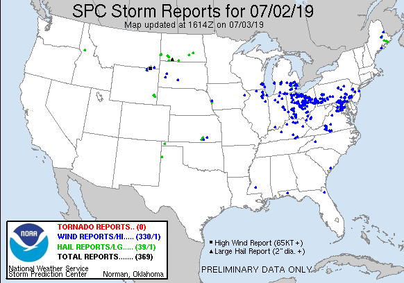
National Storm Reports:
Environment
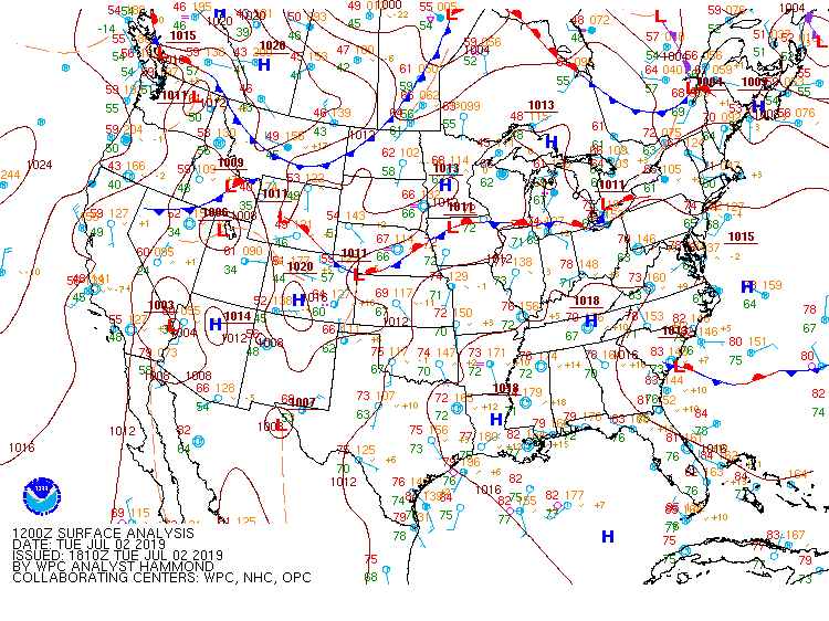
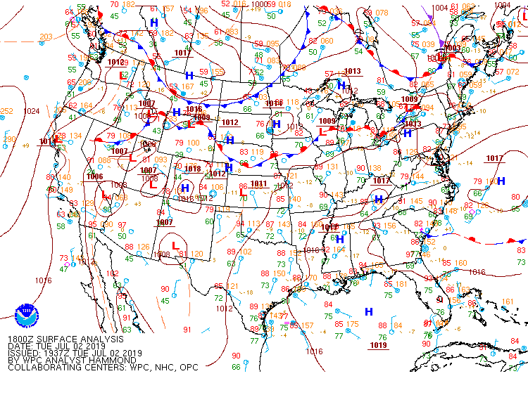
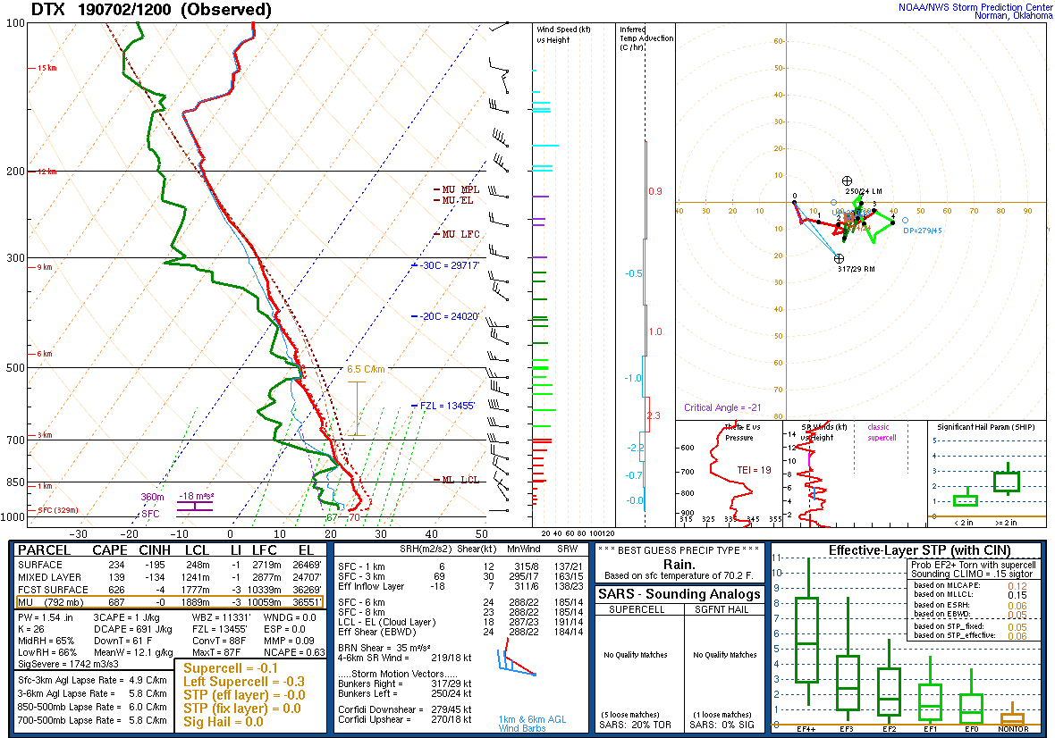
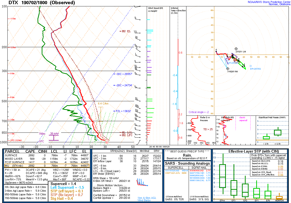
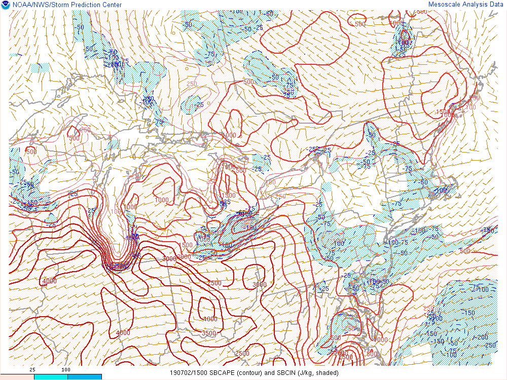
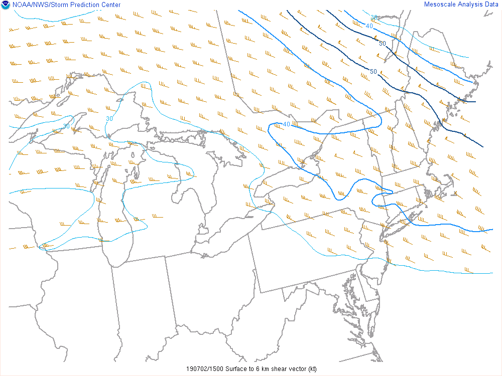
July 2 started with an upper level ridge over the northern Great Lakes area slowly flattening due to a shortwave passing over Quebec allowing for subtle height falls over southeast Michigan. A stationary front was also draped across the southern part of southeast Michigan (Figure 1). The previous evening, a strong line of storms moved through Wisconsin and by the morning of July 2, the now weaker remnants of those storms pushed across the Tri-Cities and Thumb region with some flanking showers across the northern Metro Detroit area. By noontime, these showers had moved into Canada allowing for a brief drying out. The upper level ridge had allowed for a hot, humid airmass to push up from the south and settle across the region which provided the base instability for storms. This instability was further amplified in the afternoon with daytime heating allowing moderate midlevel lapse rates to develop, seen in the 18Z and 00Z soundings (Figures 5 & 6), and CAPE to reach the 2000-3000 J./kg range (Figure 7). Moderate bulk shear of ~30kt would develop over the course of the afternoon allowing for better storm organization (Figure 8). The moderate lapse rates and shear would limit the potential for hail production however hail up to 1” would be possible in slower mover storms. High atmospheric moisture content - precipitable water values of ~1.75 inches – would allow for heavy downpours in storms.
The morning cap slowly eroded by the early afternoon allowing for storms to begin to fire up across central southern Michigan. These storms initiated along that weak front which had pushed a bit further north over southern Michigan (Figure 2). Over the course of the day, the front slowly sagged back south keeping a convergence boundary for storms to initiate on (Figure 3). After initiating over central southern Michigan, the storms tracked east over southeastern Michigan into the previously described environment which allowed for significant strengthening. Some initial isolated cells produced hail up to 1” near the Livingston-Washtenaw county line. After which more storms initiated and grouped together limiting the hail potential but increasing damaging wind potential. The bulk of storms trained along the I-96 corridor and one of these storms became particularly strong producing severe winds gusts of up to 60mph causing widespread damage including snapping and downing trees and downing powerlines. At the same time as the storms began moving along the I-96 corridor, some isolated storms fired up over southern southeast Michigan and rapidly strengthened producing severe winds up to 60 mph. Late afternoon a north-south oriented line of storms developed over west Michigan but as the line reached southeastern Michigan, the sun was setting greatly reducing instability and prevented any severe development.
 |
 |
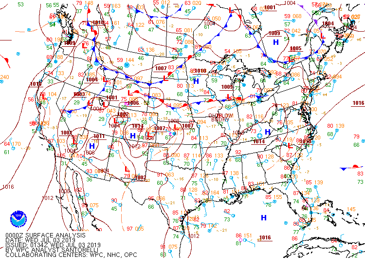 |
| Figure 1: Surface map, valid 12 UTC July 2, 2019. | Figure 2: Surface map, valid 18 UTC July 2, 2019. | Figure 3: Surface map, valid 00 UTC July 3, 2019. |
 |
 |
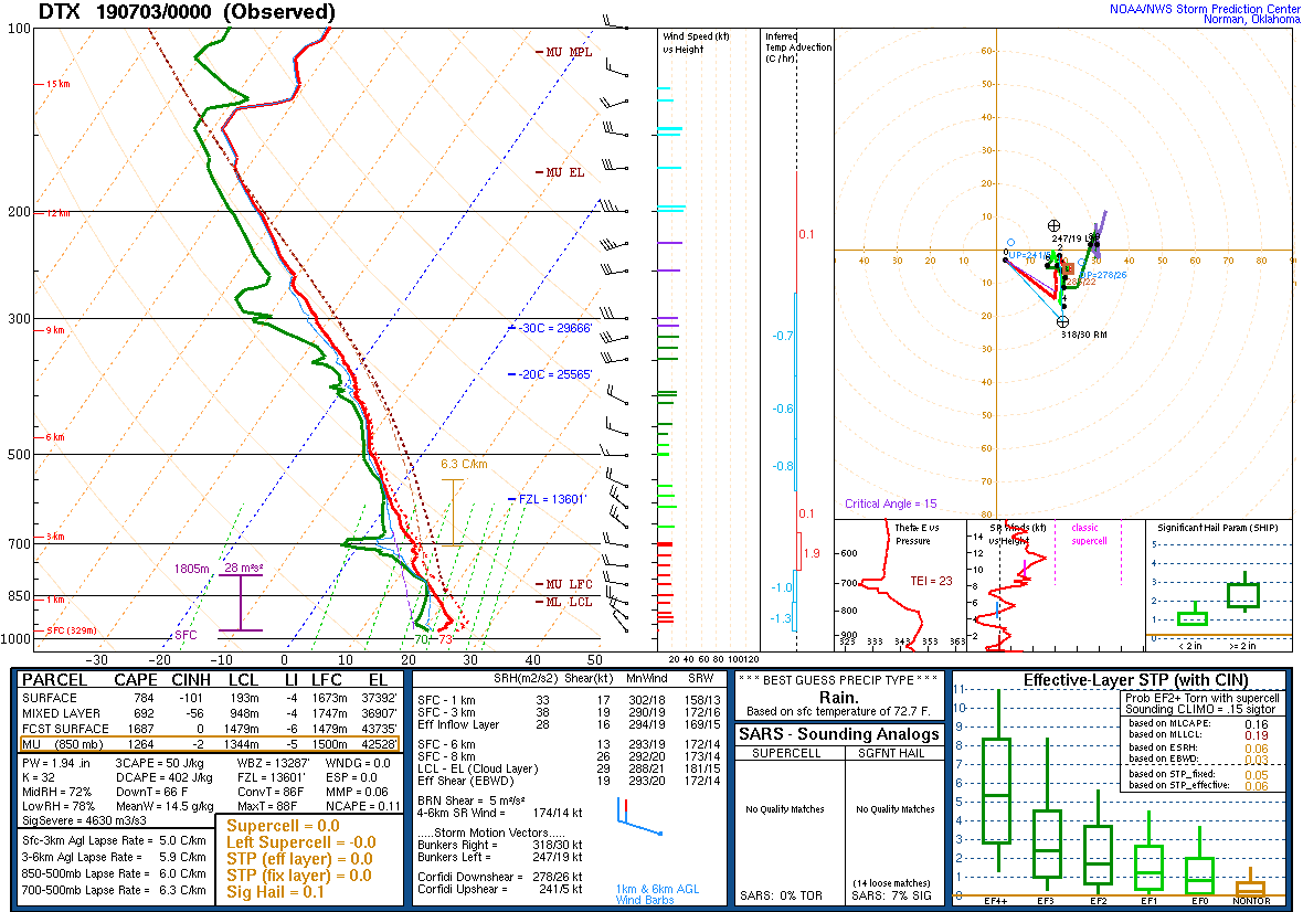 |
| Figure 4: DTX upper air sounding, valid 12 UTC July 2, 2019. | Figure 5: DTX upper air sounding, valid 18 UTC July 2, 2019. | Figure 6: DTX upper air sounding, valid 00 UTC July 3, 2019. |
 |
 |
|
| Figure 7: Loop of surface-based Convective Available Potential Energy (CAPE), valid from 15 to 23 UTC July 2, 2019. | Figure 8: Loop of bulk 0-6km wind shear, valid from 15 to 23 UTC July 2, 2019. |
 |
Media use of NWS Web News Stories is encouraged! Please acknowledge the NWS as the source of any news information accessed from this site. |
|

