Overview
Two rounds of thunderstorms impacted Southeastern Michigan on August 11: the first during the afternoon and the second during the late evening into the following morning. The first round produced widespread severe wind gusts across the area between 3 and 5pm as a well-organized line swept eastward across the state. This line knocked out power for hundreds of thousands of customers as widespread tree and power line damage occurred. A wind gust of 75 mph was measured in Mt. Clemens and prompted the issuance of NWS Detroit's first "Destructive" Severe Thunderstorm Warning. A lull in activity followed for much of the evening before the next round of storms tracked eastward across the region after 10pm. Severe reports were more isolated with this round, but abundant moisture moved in and led to repeated rounds of training thunderstorms that resulted in prolonged heavy rain and flooding overnight. Flash Flood Warnings were issued for Livingston County and the Detroit Metro region where some areas saw 3 to 5 inches of rain. Additional severe storms occurred the early morning of the 12th along and south of the I-94 corridor before storms finally moved out. In all, 9 Severe Thunderstorm Warnings, 2 Flash Flood Warnings, and 3 Special Marine Warnings were issued. According to DTE and Consumers Energy outage reports, nearly 850,000 customers across the state lost power due to the storms on August 11 as well as a round of storms on the 10th.
Photos
 |
 |
 |
|
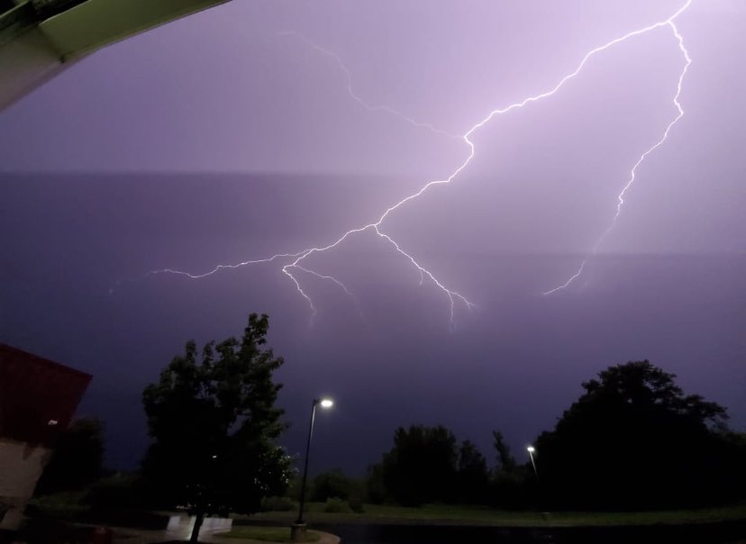
Berkley Credit: Isaac Polanski |
Brighton Credit: Jason Rutherford |
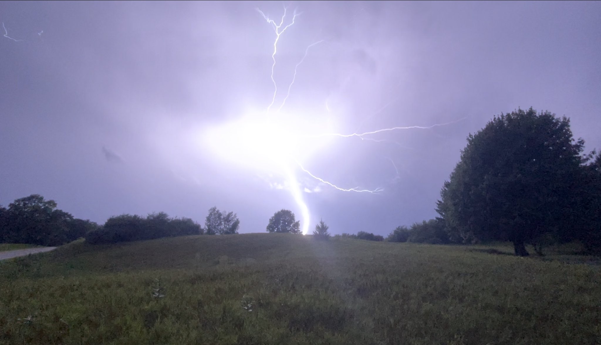
Dexter Credit: Frank Marsik |
 |
 |
 |
|
Fenton Credit: Ben Kowalski |
Flushing Credit: Mallory Pearson |
Holly Credit: Jenn Schanz |
 |
 |
 |
|
Holly Credit: Jenn Schanz |
Lapeer Credit: Devin Baker |
Milan Credit: Nick Dewhirst |
 |
 |
 |
|
Milan Credit: Nick Dewhirst |
Royal Oak Credit: Isaac Polanski |
Wyandotte Credit: Josh Halasy |
Radar
|
First round of storms during the afternoon:
Second round of storms overnight into the morning:
|
|
Click to Enlarge Radar loop courtesy of Iowa Environmental Mesonet (IEM) |
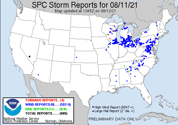
Storm Reports
 |
|
Map of Local Storm Reports |
 |
|
Observed Rainfall Totals |
Severe Weather Local Storm Reports:
PRELIMINARY LOCAL STORM REPORT...SUMMARY
NATIONAL WEATHER SERVICE DETROIT/PONTIAC MI
1135 AM EDT THU AUG 12 2021

..TIME...   ...EVENT...      ...CITY LOCATION...     ...LAT.LON...
..DATE...   ....MAG....      ..COUNTY LOCATION..ST.. ...SOURCE....
            ..REMARKS..

0301 PM     TSTM WND GST     5 NNE BRITTON           42.05N 83.80W
08/11/2021  E70.00 MPH       LENAWEE            MI   TRAINED SPOTTER

            ESTIMATED 70 MPH WINDS. TREES DOWN OVER ONE FOOT
            DIAMETER.

0308 PM     TSTM WND DMG     HAMBURG                 42.45N 83.80W
08/11/2021                   LIVINGSTON         MI   TRAINED SPOTTER

            REPORTS OF MULTIPLE TREES AND POWER LINES DOWN RELAYED
            VIA SOCIAL MEDIA.

0308 PM     TSTM WND DMG     2 WNW MILAN             42.10N 83.72W
08/11/2021                   WASHTENAW          MI   TRAINED SPOTTER

            NUMEROUS LARGE HEALTHY TREES UPROOTED AND DOWNED POWER
            LINES.

0312 PM     TSTM WND DMG     4 W BRIGHTON            42.54N 83.87W
08/11/2021                   LIVINGSTON         MI   PUBLIC

            LARGE TREE DOWN BLOCKING ROAD NEAR CHILSON AND COON LAKE
            RD...CORRECTED TO INCLUDE CROSSROADS

0313 PM     TSTM WND GST     4 S ANN ARBOR           42.22N 83.74W
08/11/2021  M58.00 MPH       WASHTENAW          MI   ASOS

            MEASURED AT KARB.

0315 PM     TSTM WND DMG     HARTLAND                42.66N 83.75W
08/11/2021                   LIVINGSTON         MI   TRAINED SPOTTER

            REPORTS FROM SEVERAL SOURCES OF NUMEROUS TREES DOWN NEAR
            HARTLAND.

0317 PM     TSTM WND DMG     5 S DUNDEE              41.89N 83.65W
08/11/2021                   MONROE             MI   TRAINED SPOTTER

            REPORTS OF NUMEROUS TREES AND POWER LINES DOWN.

0317 PM     TSTM WND DMG     2 SSW MILFORD           42.56N 83.62W
08/11/2021                   OAKLAND            MI   NWS EMPLOYEE

            REPORT OF LARGE TREE DOWN ON MILFORD RD NEAR ENTRANCE TO
            KENSINGTON METROPARK.

0321 PM     TSTM WND DMG     IDA                     41.91N 83.57W
08/11/2021                   MONROE             MI   EMERGENCY MNGR

            TREE LINE FLATTENED. REPORTS OF OVER 40 TREES DOWN IN THE
            AREA VIA DISPATCH.

0323 PM     TSTM WND GST     5 SSW CANTON            42.24N 83.53W
08/11/2021  M60.00 MPH       WAYNE              MI   ASOS

            MEASURED AT DETROIT WILLOW RUN AIRPORT.

0327 PM     TSTM WND DMG     LINDEN                  42.82N 83.78W
08/11/2021                   GENESEE            MI   NWS EMPLOYEE

            REPORTED NUMEROUS TREES DOWN.

0330 PM     TSTM WND DMG     HIGHLAND                42.64N 83.62W
08/11/2021                   OAKLAND            MI   PUBLIC

            REPORT OF MULTIPLE WIRES AND TREES DOWN THROUGHOUT
            HIGHLAND TOWNSHIP.

0330 PM     TSTM WND DMG     MONROE                  41.92N 83.39W
08/11/2021                   MONROE             MI   PUBLIC

            SEVERAL LARGE TREE LIMBS DOWN AND SOME LARGE TREES
            UPROOTED. REPORTS RELAYED VIA SOCIAL MEDIA PHOTOS.

0330 PM     TSTM WND DMG     5 SSW ROMULUS           42.16N 83.41W
08/11/2021                   WAYNE              MI   BROADCAST MEDIA

            LARGE TREE OVER 1.5 FOOT DIAMETER DOWN ON POWER LINE.

0330 PM     TSTM WND DMG     4 E FENTON              42.81N 83.63W
08/11/2021                   OAKLAND            MI   TRAINED SPOTTER

            SEVERAL 10-12 INCH DIAMETER TREE LIMBS DOWN.

0339 PM     TSTM WND DMG     BURTON                  43.00N 83.62W
08/11/2021                   GENESEE            MI   911 CALL CENTER

            DISPATCH REPORTS RECEIVING SEVERAL DOZEN CALLS OF TREES
            AND POWER LINES DOWN, MAINLY SOUTH OF THE I-69 CORRIDOR.


0342 PM     TSTM WND GST     1 E ORTONVILLE          42.85N 83.42W
08/11/2021  E60.00 MPH       OAKLAND            MI   COUNTY OFFICIAL

            COUNTY OFFICIAL ESTIMATES 60 MPH GUST.

0343 PM     TSTM WND DMG     BERKLEY                 42.50N 83.19W
08/11/2021                   OAKLAND            MI   TRAINED SPOTTER

            REPORTS FROM SEVERAL SOURCES OF TREES AND POWER LINES
            DOWN NEAR BERKLEY.

0343 PM     TSTM WND DMG     WYANDOTTE               42.21N 83.16W
08/11/2021                   WAYNE              MI   PUBLIC

            LARGE TREE ACROSS ROAD NEAR HENRY FORD HOSPITAL IN
            WYANDOTTE.

0344 PM     TSTM WND GST     2 ENE ROMULUS           42.23N 83.33W
08/11/2021  E63.00 MPH       WAYNE              MI   ASOS

            MEASURED AT DETROIT METRO AIRPORT...CORRECTED AS TSTM
            WIND GST.

0344 PM     TSTM WND DMG     AUBURN HILLS            42.67N 83.24W
08/11/2021                   OAKLAND            MI   TRAINED SPOTTER

            LARGE TREE DOWN IN BACKYARD.

0349 PM     MARINE TSTM WIND 5 E ESTRAL BEACH        42.00N 83.14W
08/11/2021  M55.00 MPH       LEZ444             MI   BUOY

            MEASURED AT DETROIT RIVER LIGHT.

0353 PM     TSTM WND GST     ESE OXFORD              42.82N 83.25W
08/11/2021  M60.00 MPH       OAKLAND            MI   MESONET

            MEASURED VIA MESONET.

0400 PM     TSTM WND GST     2 E MOUNT CLEMENS       42.60N 82.84W
08/11/2021  M75.00 MPH       MACOMB             MI   AWOS

            MEASURED AT SELFRIDGE AIR NATIONAL GUARD BASE.

0401 PM     MARINE TSTM WIND 2 S GROSSE POINTE       42.36N 82.91W
08/11/2021  E59.00 MPH       LCZ460             MI   BUOY

            MEASURED AT PECHE ISLAND LIGHT.

0404 PM     TSTM WND GST     4 NNE GROSSE POINTE     42.43N 82.87W
08/11/2021  M57.00 MPH       LCZ460             MI   BUOY

            MEASURED AT GROSSE PT LIGHT.

0405 PM     MARINE TSTM WIND 5 ESE MOUNT CLEMENS     42.57N 82.80W
08/11/2021  M54.00 MPH       MACOMB             MI   MESONET

            MEASURED AT LAKE ST. CLAIR METROPARK.

0430 PM     HEAVY RAIN       ATLAS                   42.94N 83.53W
08/11/2021  M1.20 INCH       GENESEE            MI   TRAINED SPOTTER

            1 HOUR RAINFALL TOTAL.

0442 PM     MARINE TSTM WIND 1 NNE PORT HURON        43.01N 82.42W
08/11/2021  M45.00 MPH       ST. CLAIR          MI   MESONET

            MEASURED AT FORT GRATIOT LIGHT.

1048 PM     TSTM WND DMG     FLUSHING                43.06N 83.84W
08/11/2021                   GENESEE            MI   BROADCAST MEDIA

            MULTIPLE TREE UPROOTED AND LARGE TREE LIMBS DOWN.

0433 AM     FLOOD            1 S HOWELL              42.59N 83.93W
08/12/2021                   LIVINGSTON         MI   DEPT OF HIGHWAYS

            MDOT REPORTS EB I-96 AFTER PINCKNEY ROAD IS CLOSED DUE TO
            FLOODING.

0500 AM     HEAVY RAIN       ROSEVILLE               42.51N 82.94W
08/12/2021  M2.26 INCH       MACOMB             MI   CO-OP OBSERVER

            24 HOUR RAINFALL.

0500 AM     HEAVY RAIN       4 ENE GRAND BLANC       42.94N 83.53W
08/12/2021  M1.90 INCH       GENESEE            MI   PUBLIC

            5 HOUR RAINFALL.

0630 AM     HEAVY RAIN       4 NW PINCKNEY           42.50N 84.00W
08/12/2021  M4.21 INCH       LIVINGSTON         MI   TRAINED SPOTTER

            6 HOUR RAINFALL.

0637 AM     TSTM WND DMG     MANITOU BEACH           41.97N 84.31W
08/12/2021                   LENAWEE            MI   PUBLIC

            SOCIAL MEDIA VIDEO OF MULTIPLE LARGE TREES SNAPPED AROUND
            DEVILS LAKE.

0647 AM     TSTM WND DMG     2 W MANCHESTER          42.15N 84.07W
08/12/2021                   WASHTENAW          MI   DEPT OF HIGHWAYS

            POWER LINES DOWN OVER THE ROADWAY.

0700 AM     HEAVY RAIN       4 WSW CHESANING         43.17N 84.21W
08/12/2021  M1.10 INCH       SAGINAW            MI   TRAINED SPOTTER

            24 HOUR RAINFALL.

0700 AM     HEAVY RAIN       S DEXTER                42.33N 83.88W
08/12/2021  M1.93 INCH       WASHTENAW          MI   TRAINED SPOTTER

            24 HOUR RAINFALL.

0700 AM     HEAVY RAIN       4 S DETROIT             42.32N 83.11W
08/12/2021  M2.32 INCH       WAYNE              MI   COCORAHS

            24 HOUR RAINFALL.

0700 AM     HEAVY RAIN       4 N BURTON              43.05N 83.62W
08/12/2021  M1.51 INCH       GENESEE            MI   CO-OP OBSERVER

            24 HOUR RAINFALL.

0700 AM     HEAVY RAIN       BLOOMFIELD HILLS        42.58N 83.25W
08/12/2021  M2.21 INCH       OAKLAND            MI   TRAINED SPOTTER

            24 HOUR RAINFALL.

0700 AM     FLOOD            4 NW ST. CLAIR SHORES   42.52N 82.95W
08/12/2021                   MACOMB             MI   TRAINED SPOTTER

            FLOODED ROADWAYS AROUND 13 MILE AND GROESBECK HIGHWAY.

0700 AM     HEAVY RAIN       LINDEN                  42.82N 83.78W
08/12/2021  M3.94 INCH       GENESEE            MI   CO-OP OBSERVER

            24 HOUR RAINFALL.

0700 AM     HEAVY RAIN       SE ANN ARBOR            42.28N 83.73W
08/12/2021  M3.53 INCH       WASHTENAW          MI   CO-OP OBSERVER

            24 HOUR RAINFALL.

0700 AM     HEAVY RAIN       MANCHESTER              42.15N 84.04W
08/12/2021  M2.45 INCH       WASHTENAW          MI   CO-OP OBSERVER

            24 HOUR RAINFALL.

0700 AM     HEAVY RAIN       CANTON                  42.31N 83.48W
08/12/2021  M2.40 INCH       WAYNE              MI   COCORAHS

            24 HOUR RAINFALL.

0700 AM     HEAVY RAIN       WHITMORE LAKE           42.43N 83.75W
08/12/2021  M3.56 INCH       LIVINGSTON         MI   CO-OP OBSERVER

            24 HOUR RAINFALL.

0700 AM     HEAVY RAIN       OWOSSO                  43.00N 84.18W
08/12/2021  M1.92 INCH       SHIAWASSEE         MI   CO-OP OBSERVER

            24 HOUR RAINFALL.

0700 AM     HEAVY RAIN       FLINT                   43.02N 83.69W
08/12/2021  M1.63 INCH       GENESEE            MI   OFFICIAL NWS OBS

            24 HOUR RAINFALL AT FLINT BISHOP AIRPORT.

0700 AM     HEAVY RAIN       2 SW SHELBY TOWNSHIP    42.65N 83.06W
08/12/2021  M1.07 INCH       MACOMB             MI   COCORAHS

            24 HOUR RAINFALL.

0700 AM     HEAVY RAIN       2 N CLINTON             42.10N 83.97W
08/12/2021  M1.29 INCH       WASHTENAW          MI   COCORAHS

            24 HOUR RAINFALL.

0700 AM     HEAVY RAIN       2 E YPSILANTI           42.25N 83.58W
08/12/2021  M3.12 INCH       WASHTENAW          MI   TRAINED SPOTTER

            24 HOUR RAINFALL.
0700 AM     TSTM WND DMG     5 SSE ANN ARBOR         42.20N 83.70W
08/12/2021                   WASHTENAW          MI   EMERGENCY MNGR

            LARGE TREE DOWN NEAR TEXTILE RD AND MICHIGAN AVE.

0713 AM     TSTM WND DMG     ANN ARBOR               42.28N 83.73W
08/12/2021                   WASHTENAW          MI   TRAINED SPOTTER

            SPOTTER REPORTS NUMEROUS 6 TO 12 INCH DIAMETER TREES AND
            BRANCHES DOWN ACROSS THE ANN ARBOR AREA.

0724 AM     TSTM WND DMG     2 WNW ROMULUS           42.23N 83.41W
08/12/2021                   WAYNE              MI   PUBLIC

            PUBLIC REPORT OF APPROX 6 INCH DIAMETER HEALTHY TREE
            LIMBS DOWN ALONG TYLER RD BETWEEN COGSWELL AND OZGA RDS.

0730 AM     HEAVY RAIN       LAPEER                  43.05N 83.32W
08/12/2021  M1.00 INCH       LAPEER             MI   CO-OP OBSERVER

            24 HOUR RAINFALL.

0730 AM     FLOOD            5 NW ST. CLAIR SHORES   42.54N 82.97W
08/12/2021                   MACOMB             MI   TRAINED SPOTTER

            ROADWAY FLOODED AND CARS STRANDED.

0730 AM     HEAVY RAIN       GOODRICH                42.92N 83.51W
08/12/2021  M2.29 INCH       GENESEE            MI   CO-OP OBSERVER

            24 HOUR RAINFALL.

0730 AM     HEAVY RAIN       BEVERLY HILLS           42.52N 83.22W
08/12/2021  M2.30 INCH       OAKLAND            MI   PUBLIC

            24 HOUR RAINFALL.

0800 AM     HEAVY RAIN       4 SW SALINE             42.13N 83.84W
08/12/2021  M1.97 INCH       WASHTENAW          MI   CO-OP OBSERVER

            24 HOUR RAINFALL.

0800 AM     HEAVY RAIN       ROMULUS                 42.22N 83.37W
08/12/2021  M3.08 INCH       WAYNE              MI   OFFICIAL NWS OBS

            24 HOUR RAINFALL AT DETROIT METRO AIRPORT.

0800 AM     HEAVY RAIN       4 E WHITE LAKE          42.65N 83.43W
08/12/2021  M2.15 INCH       OAKLAND            MI   OFFICIAL NWS OBS

            24 HOUR RAINFALL TOTAL AT THE NWS DETROIT/PONTIAC OFFICE.


0800 AM     MARINE TSTM WIND 10 E GROSSE POINTE SHOR 42.43N 82.68W
08/12/2021  M46.00 MPH       XXX                XX   BUOY

            MEASURED AT THE LAKE ST CLAIR BUOY...CORRECTED LOCATION.

0830 AM     HEAVY RAIN       3 NW WHITE LAKE         42.69N 83.55W
08/12/2021  M2.63 INCH       OAKLAND            MI   COCORAHS

            24 HOUR RAINFALL.
0830 AM     HEAVY RAIN       4 NNW RICHMOND          42.86N 82.78W
08/12/2021  M1.52 INCH       MACOMB             MI   CO-OP OBSERVER

            24 HOUR RAINFALL.

0830 AM     HEAVY RAIN       FARMINGTON              42.46N 83.38W
08/12/2021  E2.62 INCH       OAKLAND            MI   CO-OP OBSERVER

            24 HOUR RAINFALL.

0830 AM     HEAVY RAIN       WYANDOTTE               42.21N 83.16W
08/12/2021  M2.92 INCH       WAYNE              MI   CO-OP OBSERVER

            24 HOUR RAINFALL.
0900 AM     HEAVY RAIN       DEARBORN                42.31N 83.21W
08/12/2021  M3.22 INCH       WAYNE              MI   CO-OP OBSERVER

            24 HOUR RAINFALL.
0900 AM     HEAVY RAIN       SOUTHGATE               42.20N 83.21W
08/12/2021  M3.04 INCH       WAYNE              MI   TRAINED SPOTTER

            24 HOUR RAINFALL.

0900 AM     HEAVY RAIN       2 W LAPEER              43.05N 83.36W
08/12/2021  M1.22 INCH       LAPEER             MI   CO-OP OBSERVER

            24 HOUR RAINFALL.

1000 AM     HEAVY RAIN       WYANDOTTE               42.21N 83.16W
08/12/2021  M3.04 INCH       WAYNE              MI   CO-OP OBSERVER

            18 HOUR RAINFALL.

1000 AM     HEAVY RAIN       FOWLERVILLE             42.66N 84.07W
08/12/2021  M4.90 INCH       LIVINGSTON         MI   TRAINED SPOTTER

            24 HOUR RAINFALL.

1000 AM     HEAVY RAIN       GARDEN CITY             42.33N 83.33W
08/12/2021  M3.75 INCH       WAYNE              MI   TRAINED SPOTTER

            34 HOUR RAINFALL.

1000 AM     HEAVY RAIN       3 SSW CANTON            42.27N 83.50W
08/12/2021  M3.47 INCH       WAYNE              MI   TRAINED SPOTTER

            27 HOUR RAINFALL.
 |
|
National Storm Reports for August 11, 2021 |
Environment
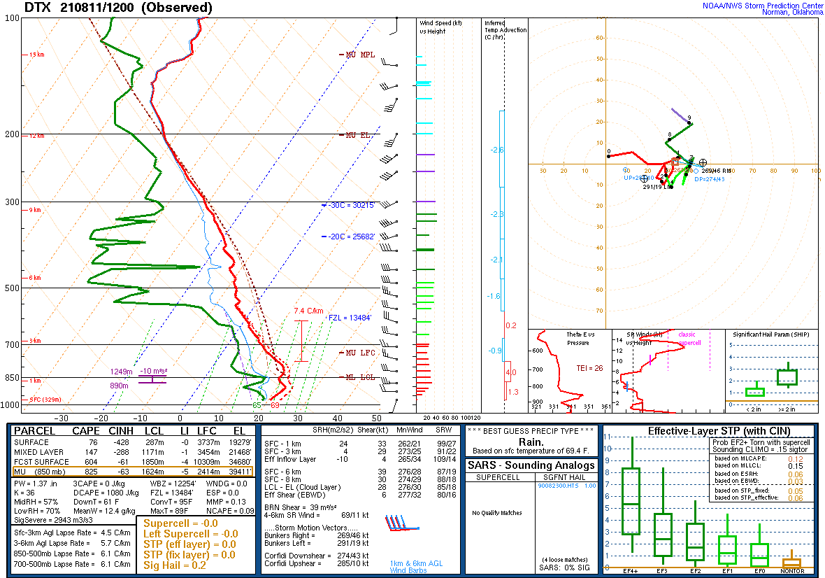
An upper trough moved from the upper Midwest toward the Great Lakes on the morning of August 11 (see Figure 15 below) with warm and moist air streaming into the region ahead of it (Figure 13). Dew points were in the upper 60s to start the day, then increased to the lower to mid 70s by mid-afternoon (Figures 1, 2, and 12). With mid-level lapse rates around 7.5 to 8.0 C/km (Figures 7 and 8), instability quickly ramped up with 2000 to 3000 J/kg of MLCAPE in place ahead of the first round of storms. A mesoscale convective system moved through the Chicago area during the late morning helped trigger storms along an instability gradient over west Michigan. Effective bulk shear on the order of 35 to 40 kt (Figure 11) allowed for quick storm development into a organized line by early afternoon. This line produced strong outflow as it progressed east with multiple localized bowing segments / wind surges resulting in straight-line wind gusts of 60 to 75 mph. This activity was limited to areas south of I-69.
A stable air mass developed in the wake of the afternoon storms and kept the area precip-free through the evening hours. A strong near-surface inversion was recorded in the 00z DTX sounding (Figure 9), showing the degree of stability. However, this sounding also showed the steep mid-level lapse rates remained in place. By late evening, a 40 to 45 kt 850mb low-level jet encroached on the area from the southwest and advected in the return of higher near-surface moisture that allowed for strong elevated instability to develop (MUCAPE rising back to 2000 J/kg). A second line of storms moved across the southern Lower Peninsula from west to east with sporadic gusts of 40 to 60 mph. Because this round of storms had strong support from the LLJ, back building and training occurred overnight with some areas seeing heavy rainfall for prolonged periods. Rainfall totals exceeded 3 inches in several counties while localized totals near 5 inches occurred in Livingston County. The LLJ forcing eventually waned by mid-morning but one last surge of instability and shear coincided to bring another round of strong to severe storms along and south of I-94 during the early morning hours.
Click on the images below to see them expanded.
 |
 |
 |
| Figure 1: Weather Prediction Center (WPC) surface map, valid 12 UTC 11 August 2021. | Figure 2: Weather Prediction Center (WPC) surface map, valid 18 UTC 11 August 2021. | Figure 3: Weather Prediction Center (WPC) surface map, valid 00 UTC 12 August 2021. |
 |
 |
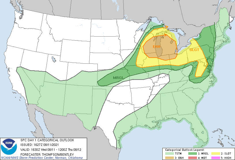 |
| Figure 4: Weather Prediction Center (WPC) surface map, valid 06 UTC 12 August 2021. | Figure 5: Weather Prediction Center (WPC) surface map, valid 12 UTC 12 August 2021. | Figure 6: SPC Day 1 Outlook, valid 1630 UTC 11 August 2021. |
 |
 |
 |
| Figure 7: KDTX observed sounding, valid 12 UTC 11 August 2021. | Figure 8: KDTX observed sounding, valid 18 UTC 12 August 2021. | Figure 9: KDTX observed sounding, valid 00 UTC 12 August 2021. |
 |
 |
 |
| Figure 10: Loop of mixed-layer CAPE, valid 18 UTC 11 August 2021 to 06 UTC 12 August 2021. | Figure 11: Loop of 0-6 km effective shear, valid 18 UTC 11 August 2021 to 06 UTC 12 August 2021. | Figure 12: Loop of surface dew point and mid-level lapse rates, valid 18 UTC 11 August 2021 to 06 UTC 12 August 2021. |
 |
 |
 |
| Figure 13: SPC 850 hPa Map, valid 12 UTC 11 August 2021. | Figure 14: SPC 500 hPa Map, valid 12 UTC 11 August 2021. | Figure 15: SPC 300 hPa Map, valid 12 UTC 11 August 2021. |
 |
Media use of NWS Web News Stories is encouraged! Please acknowledge the NWS as the source of any news information accessed from this site. |
|


