Overview
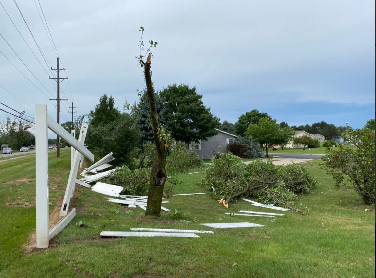
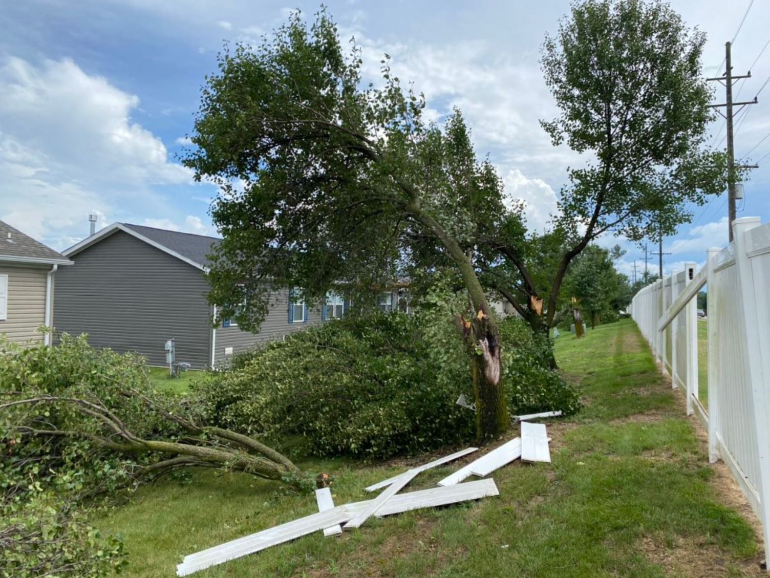
Several rounds of strong to severe thunderstorms occurred across much of southeast Michigan through the morning and afternoon hours of July 19, 2020. These thunderstorms occurred in a very warm, moist, and unstable airmass ahead of a passing cold front. These thunderstorms produced widespread reports of wind damage across the region, along with numerous rainfall reports well over an inch in several locations. News reports indicated that as much as 100,000 people lost power across southeast Michigan from the severe weather.
Photos
 |
 |
|
Belleville Credit: Nick Dewhirst |
Belleville Credit: Nick Dewhirst |
Radar
  |
|
Click to Enlarge Radar loop courtesy of Iowa Environmental Mesonet (IEM) |
Storm Reports
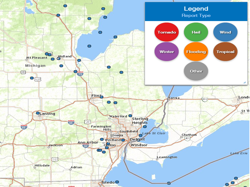
Map of severe weather reports.
Severe Weather Local Storm Reports:
PRELIMINARY LOCAL STORM REPORT...SUMMARY
NATIONAL WEATHER SERVICE DETROIT/PONTIAC MI
615 PM EDT SUN JUL 19 2020

*SEVERAL LOCATIONS ACROSS SOUTHEAST MICHIGAN ALSO RECEIVED RAINFALL
TOTALS OVER 1 INCH...INCLUDING AMOUNTS THAT FELL IN AS LITTLE AS A
HALF OF AN HOURS TIME.

..TIME...   ...EVENT...      ...CITY LOCATION...     ...LAT.LON...
..DATE...   ....MAG....      ..COUNTY LOCATION..ST.. ...SOURCE....
            ..REMARKS..

0820 AM     MARINE TSTM WIND 8 ESE AU GRES           44.02N 83.54W
07/19/2020  M56.00 MPH       LHZ421             MI   BUOY

            49 KNOTS MEASURED AT GRAVELLY SHOAL LIGHT.

0830 AM     MARINE TSTM WIND 1 NW CASEVILLE          43.95N 83.29W
07/19/2020  M45.00 MPH       LHZ421             MI   MESONET

            39 KNOTS MEASURED AT CASEVILLE LIGHT.

0830 AM     MARINE TSTM WIND 8 ESE AU GRES           44.02N 83.54W
07/19/2020  M40.00 MPH       LHZ421             MI   BUOY

            35 KNOTS MEASURED AT GRAVELLY SHOAL LIGHT.

0840 AM     MARINE TSTM WIND 12 NNW BAY PARK         43.81N 83.72W
07/19/2020  M43.00 MPH       LHZ422             MI   BUOY

            37 KNOTS MEASURED AT SAGINAW BAY LIGHT 1.

0847 AM     TSTM WND DMG     3 WNW SANFORD           43.69N 84.43W
07/19/2020                   MIDLAND            MI   911 CALL CENTER

            NUMEROUS WIRES DOWN. TIME ESTIMATED BY RADAR.

0851 AM     TSTM WND DMG     SANFORD                 43.68N 84.38W
07/19/2020                   MIDLAND            MI   911 CALL CENTER

            NUMEROUS WIRES DOWN. TIME ESTIMATED BY RADAR.

0855 AM     TSTM WND DMG     5 W MIDLAND             43.61N 84.33W
07/19/2020                   MIDLAND            MI   911 CALL CENTER

            NUMEROUS WIRES DOWN. TIME ESTIMATED BY RADAR.

0901 AM     TSTM WND DMG     MIDLAND                 43.62N 84.23W
07/19/2020                   MIDLAND            MI   911 CALL CENTER

            NUMEROUS TREES DOWN THROUGHOUT THE CITY. TIME ESTIMATED
            BY RADAR.

0907 AM     TSTM WND DMG     4 W FREELAND            43.51N 84.19W
07/19/2020                   MIDLAND            MI   911 CALL CENTER

            NUMEROUS TREES DOWN. TIME ESTIMATED BY RADAR.

0909 AM     TSTM WND DMG     BAY CITY                43.59N 83.89W
07/19/2020                   BAY                MI   911 CALL CENTER

            NUMEROUS TREES AND WIRES DOWN ACROSS CITY. TIME ESTIMATED
            BY RADAR.

0910 AM     MARINE TSTM WIND 12 NNW BAY PARK         43.81N 83.72W
07/19/2020  M41.00 MPH       LHZ422             MI   BUOY

            36 KNOTS MEASURED AT SAGINAW BAY LIGHT 1.

0927 AM     TSTM WND DMG     SAGINAW                 43.42N 83.95W
07/19/2020                   SAGINAW            MI   911 CALL CENTER

            NUMEROUS TREES AND WIRES DOWN THROUGHOUT THE CITY. TIME
            ESTIMATED BY RADAR. DISPATCH ALSO REPORTED NUMEROUS TREES
            AND WIRES DOWN THROUGHOUT SAGINAW COUNTY.

0931 AM     TSTM WND DMG     CARO                    43.49N 83.40W
07/19/2020                   TUSCOLA            MI   911 CALL CENTER

            TREES DOWN. TIME ESTIMATED BY RADAR.

0940 AM     TSTM WND DMG     KINGSTON                43.41N 83.19W
07/19/2020                   TUSCOLA            MI   911 CALL CENTER

            TREES DOWN. TIME ESTIMATED BY RADAR.

1022 AM     TSTM WND DMG     DAVISON                 43.03N 83.52W
07/19/2020                   GENESEE            MI   911 CALL CENTER

            TREES DOWN. TIME ESTIMATED BY RADAR.

1035 AM     TSTM WND DMG     HADLEY                  42.95N 83.40W
07/19/2020                   LAPEER             MI   911 CALL CENTER

            NUMEROUS TREES DOWN. TIME ESTIMATED BY RADAR.

1042 AM     TSTM WND DMG     METAMORA                42.94N 83.29W
07/19/2020                   LAPEER             MI   911 CALL CENTER

            NUMEROUS TREES DOWN. TIME ESTIMATED BY RADAR.

1150 AM     TSTM WND DMG     5 SSW ROMEO             42.74N 83.04W
07/19/2020                   MACOMB             MI   911 CALL CENTER

            TREES DOWN.

1214 PM     TSTM WND DMG     4 NNW CANTON            42.37N 83.51W
07/19/2020                   WAYNE              MI   PUBLIC

            2 TO 3 INCH DIAMETER TREE LIMBS DOWN WITH ESTIMATED WINDS
            50 TO 55 MPH. TIME ESTIMATED BY RADAR.

0153 PM     TSTM WND DMG     4 SE YPSILANTI          42.20N 83.57W
07/19/2020                   WASHTENAW          MI   EMERGENCY MNGR

            WASHTENAW COUNTY EMERGENCY MANAGEMENT DEPT RELAYED A
            REPORT FROM A SENIOR FIRE OFFICIAL REGARDING SEVERAL
            LARGE TREES DOWN ON MOBILE HOMES IN THE 6400 BLOCK OF
            LAKE DRIVE.

0154 PM     TSTM WND DMG     5 SSW CANTON            42.24N 83.53W
07/19/2020                   WAYNE              MI   LAW ENFORCEMENT

            VAN BUREN TWP POLICE REPORTED DAMAGE TO SEVERAL BUILDINGS
            AT KYIP WILLOW RUN AIRPORT AND AN OVERTURNED SEMI.

0156 PM     TSTM WND GST     5 SSW CANTON            42.24N 83.53W
07/19/2020  M62.00 MPH       WAYNE              MI   ASOS

            54 KNOT THUNDERSTORM WIND GUST MEASURED AT WILLOW RUN
            AIRPORT.

0157 PM     TSTM WND DMG     5 SE YPSILANTI          42.20N 83.54W
07/19/2020                   WASHTENAW          MI   TRAINED SPOTTER

            NUMEROUS LARGE BRANCHES, TREES, AND POWER LINES DOWN AT
            RAWSONVILLE RD AND TEXTILE/HURON RIVER DR.

0202 PM     TSTM WND DMG     6 SSE CANTON            42.24N 83.43W
07/19/2020                   WAYNE              MI   TRAINED SPOTTER

            SEVERAL TREES DOWN ALONG HANNAN ROAD SOUTH OF ECORSE
            ROAD.

0203 PM     TSTM WND DMG     2 SW WESTLAND           42.30N 83.41W
07/19/2020                   WAYNE              MI   PUBLIC

            NUMEROUS LARGE TREES DOWN AND POWER LINES. MINOR DAMAGE
            TO NEARBY HOMES DUE FALLEN TREES.

0205 PM     TSTM WND DMG     2 S BELLEVILLE          42.17N 83.48W
07/19/2020                   WAYNE              MI   TRAINED SPOTTER

            LARGE TREE DOWN ON HOME NEAR SUMPTER RD AND PARIS DR.

0226 PM     TSTM WND DMG     3 WSW DETROIT           42.36N 83.16W
07/19/2020                   WAYNE              MI   PUBLIC

            NUMEROUS TREES DOWN.

0240 PM     MARINE TSTM WIND 2 S GROSSE POINTE       42.36N 82.91W
07/19/2020  M43.00 MPH       LCZ460             MI   BUOY

            37 KNOTS MEASURED AT PECHE ISLAND LIGHT.

0246 PM     MARINE TSTM WIND 4 NNE GROSSE POINTE     42.43N 82.87W
07/19/2020  M59.00 MPH       LCZ460             MI   MESONET

            51 KNOTS MEASURED AT GROSSE POINTE YACHT CLUB.

0250 PM     MARINE TSTM WIND 5 ESE MOUNT CLEMENS     42.57N 82.80W
07/19/2020  M50.00 MPH       MACOMB             MI   MESONET

            43 KNOTS MEASURED AT LAKE ST. CLAIR METROPARK.
National Storm Reports (for July 19, 2020):
Environment
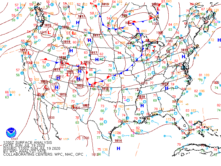
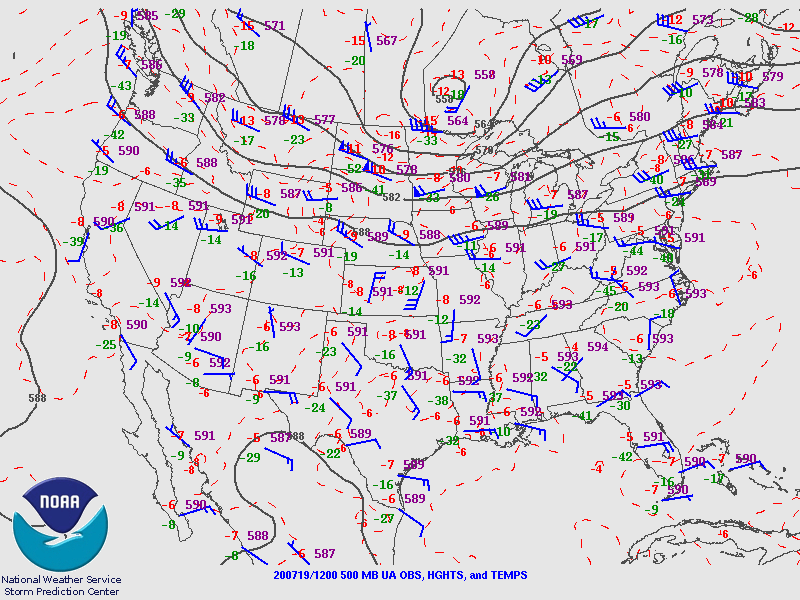
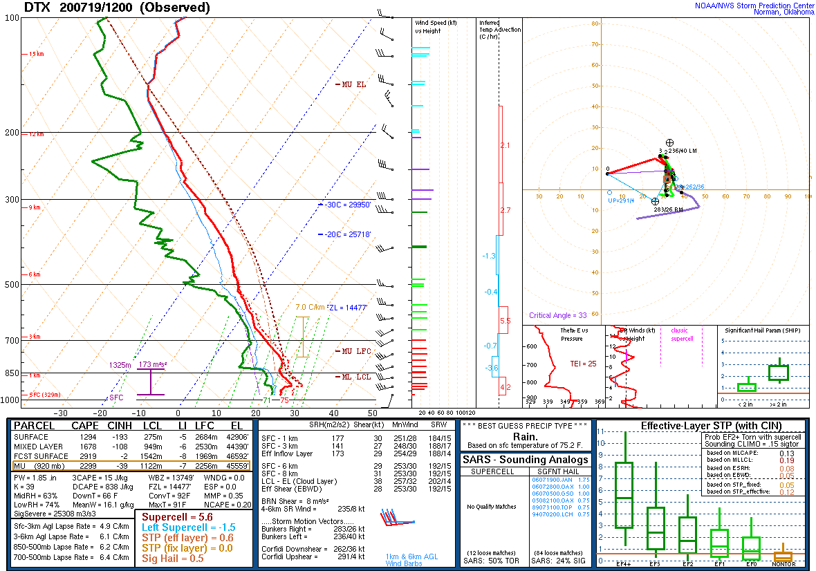
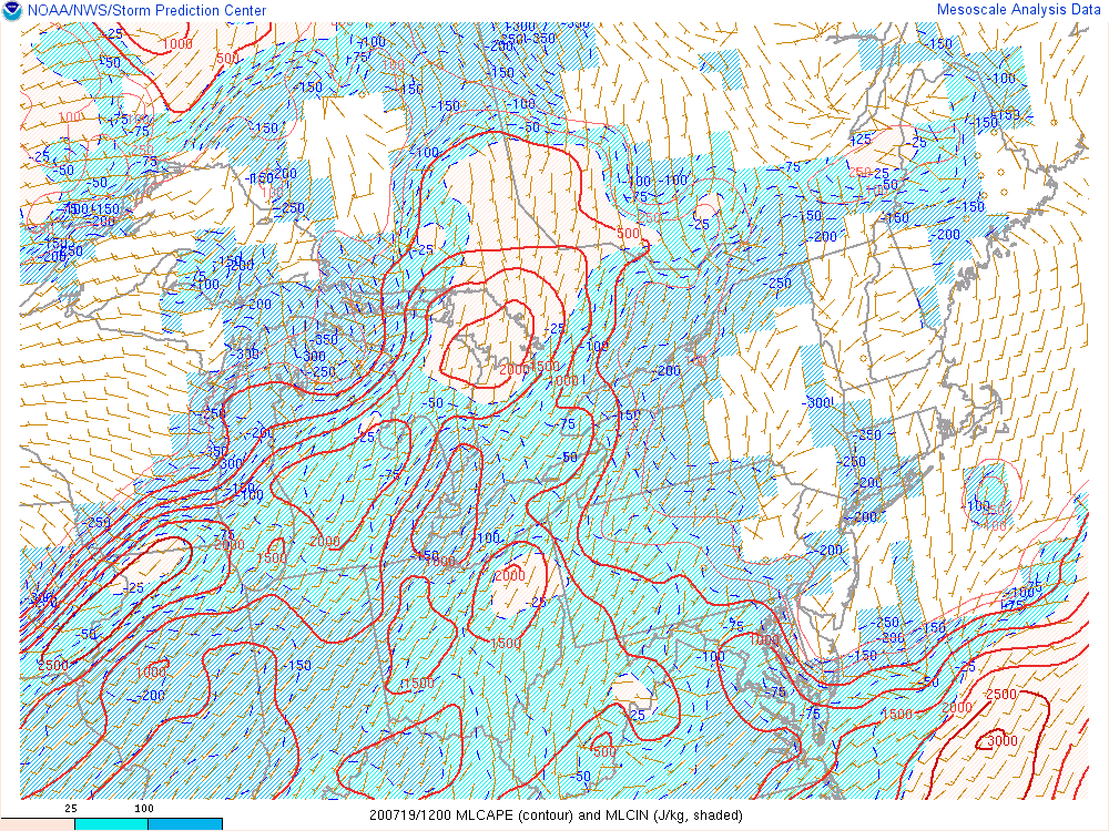
Before sunrise even occurred the morning of July 19, 2020, it was already an active severe weather day across Michigan. Strong dynamics accompanying a cold front was already producing a line of severe thunderstorms across northern Lower Michigan that quickly dived southeast towards the Tri-Cities region by 8 AM EDT. At 8 AM (Fig. 1), the cold front was draped across western Lake Michigan and would be slow to move eastward heading into the afternoon hours, which would allow for the multiple rounds of thunderstorms experienced throughout the course of the day. Broad-scale height falls associated with a shortwave trough located near Lake Superior (Fig. 2) accompanied by strong upper-level diffluence (Fig. 3) also provided plenty of dynamical lift for thunderstorm development. This dynamic lift proved crucial to sustaining the thunderstorm activity through the morning hours instead of it waning and/or dissipating as it encountered a fair amount of boundary layer capping noted by substantial CIN on the 12 UTC 19 July 2020 KDTX observed sounding (Fig. 4), and also noted on the 13 UTC 19 July 2020 MLCAPE Storm Prediction Center (SPC) mesoanalysis. The first round of thunderstorms featured Severe Thunderstorm Warnings across the Tri-Cities, portions of the Saginaw Valley and Thumb, as well as Special Marine Warnings for Saginaw Bay. Hard hit areas included portions of Bay, Tuscola, Midland, and Saginaw counties where numerous trees and wires down were reported.
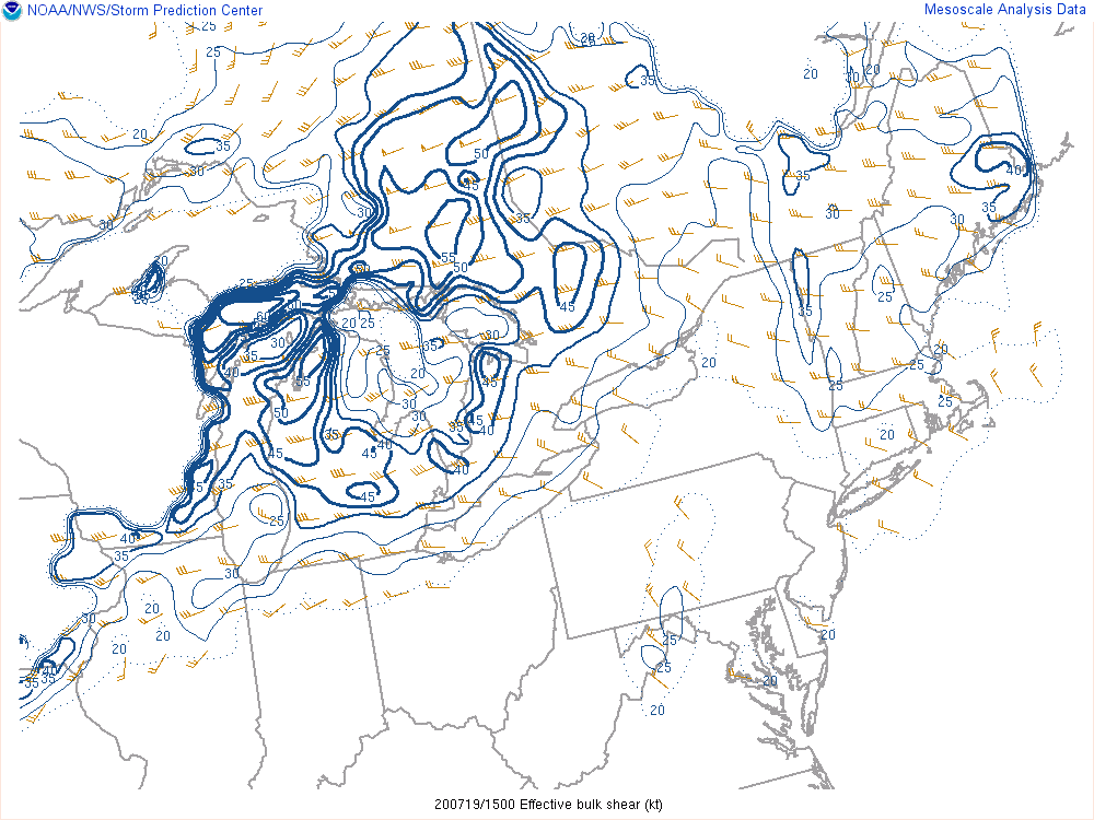
As this first wave of activity began to slightly fade, an outflow boundary diving southward from it quickly fired additional thunderstorms along central portions of the region down towards portions of the northern Detroit metro. The outflow boundary played a crucial mesoscale role in providing a local source of lift to break the aforementioned cap that remained in place across the region, which could be visibly seen in the KDTX sounding in the 850-750 hPa layer (Fig. 4). While the outflow boundary was certainly important for round two, the overall environment setup was primed for reinvigorated thunderstorm development. Surface dewpoints were into the low/mid 70s F across the region, with an enhanced region of southwesterly low-level winds transporting additional moist unstable air into the region ahead of the cold front (Fig. 6). Although forecast high temperatures ultimately did not reach the anticipated lower 90s F, the combination of 80s/70s yielded plenty of instability with MLCAPE values above 1500 J/kg. Strong enough winds aloft ahead of the cold front allowed for effective bulk shear values in excess of 35 knots (Fig. 7), which enabled robust updraft organization and the observed strong to severe multicell clusters. The second round of thunderstorms resulted in Severe Thunderstorm Warnings along the I-69 corridor and several reports of wind damage in Genesee and Lapeer counties.
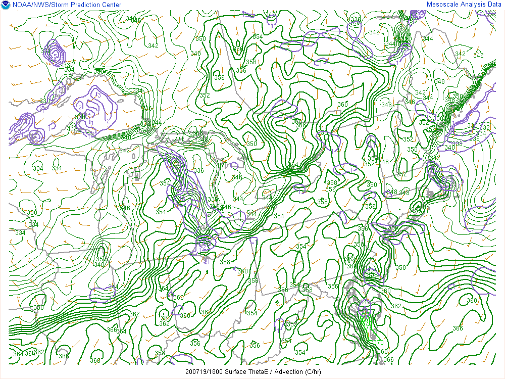
A third and final wave of thunderstorms moved through during the early afternoon hours along the I-94 corridor and into the greater Detroit metro with damaging winds. This final wave developed along a composite theta-e boundary (Fig. 8) and weak differential heating boundary (not shown) from the earlier morning convection. Hardest hit areas in this third and final wave included portions of Ypsilanti, western Wayne county, and Lake St. Clair where wind gusts around 50 knots were observed.
Click on the images below to see them expanded.
 |
 |
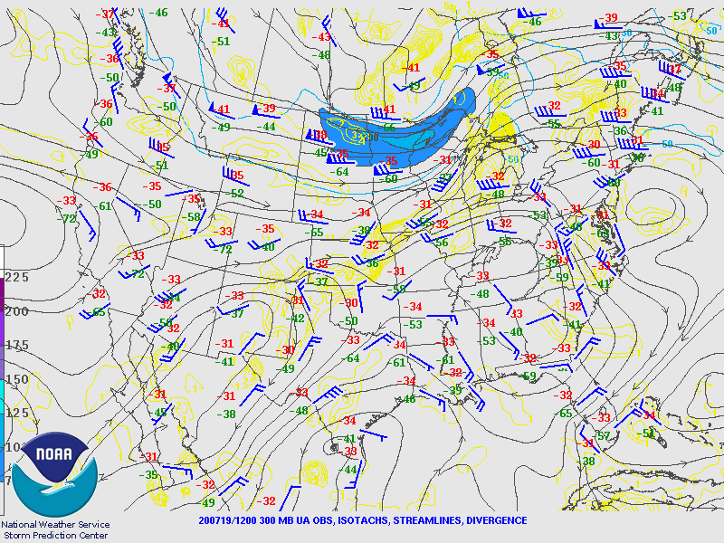 |
| Figure 1: Weather Prediction Center (WPC) surface map, valid 12 UTC 19 July 2020. | Figure 2: SPC 500 hPa map, valid 12 UTC 19 July 2020. | Figure 3: SPC 300 hPa map, valid 12 UTC 19 July 2020. |
 |
 |
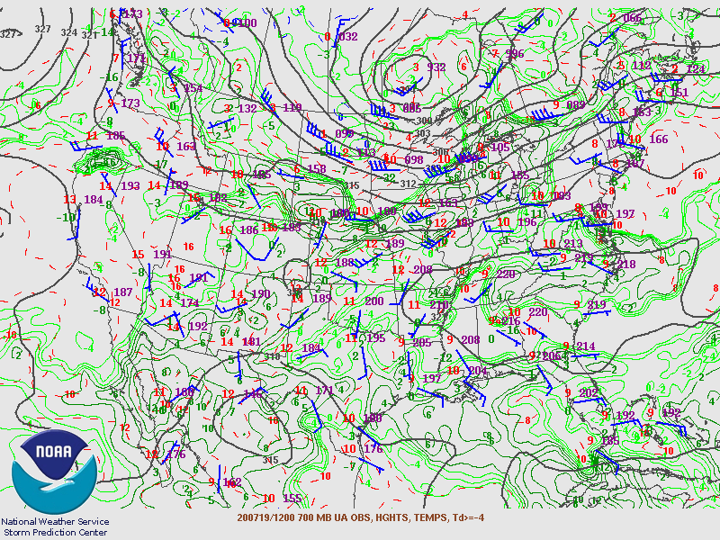 |
| Figure 4: KDTX observed sounding, valid 12 UTC 19 July 2020. | Figure 5: SPC MLCAPE mesoanalysis, valid 13 UTC 19 July 2020. | Figure 6: SPC 700 hPa map, valid 12 UTC 19 July 2020. |
 |
 |
|
| Figure 7: SPC bulk effective shear mesoanalysis, valid 15 UTC 19 July 2020. | Figure 8: SPC surface theta-e mesoanalysis, valid 18 UTC 19 July 2020. |
 |
Media use of NWS Web News Stories is encouraged! Please acknowledge the NWS as the source of any news information accessed from this site. |
 |