Overview
Numerous severe thunderstorms affected much of southeast Michigan during the evening and early overnight hours of April 7, 2020. These thunderstorms occurred in vicinity of a seasonally strong warm front that resulted in an increasingly unstable airmass coinciding with plentiful mid and upper-level wind shear. The juxtaposition of these features over the region, aided by a weak area of low pressure and attendant stronger upper wave, further primed the environment for the multiple severe thunderstorms that occurred. All storm modes were observed during this event, including supercells and multicell bowing segments, which resulted in several reports of large hail.
Photos
 |
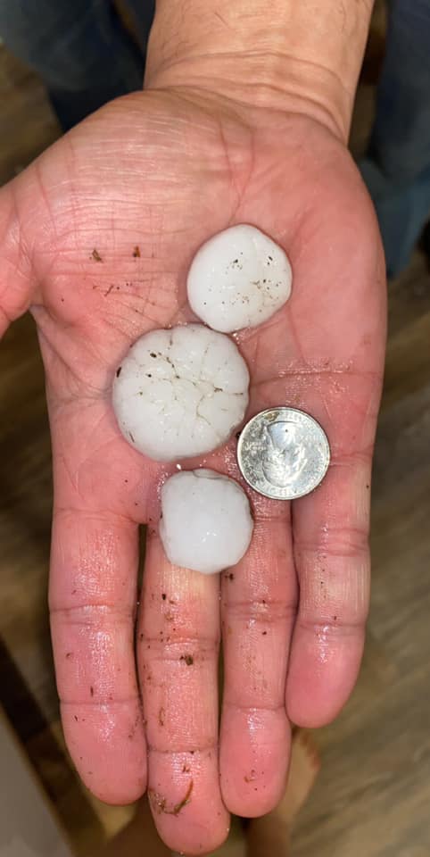 |
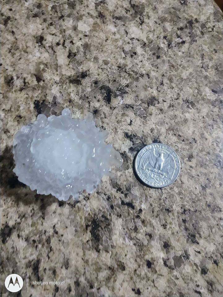 |
|
North Branch Credit: Kristen Lynn Schank |
New Hudson Credit: Ryan Tedesco |
Midland Credit: Lisa Stanick |
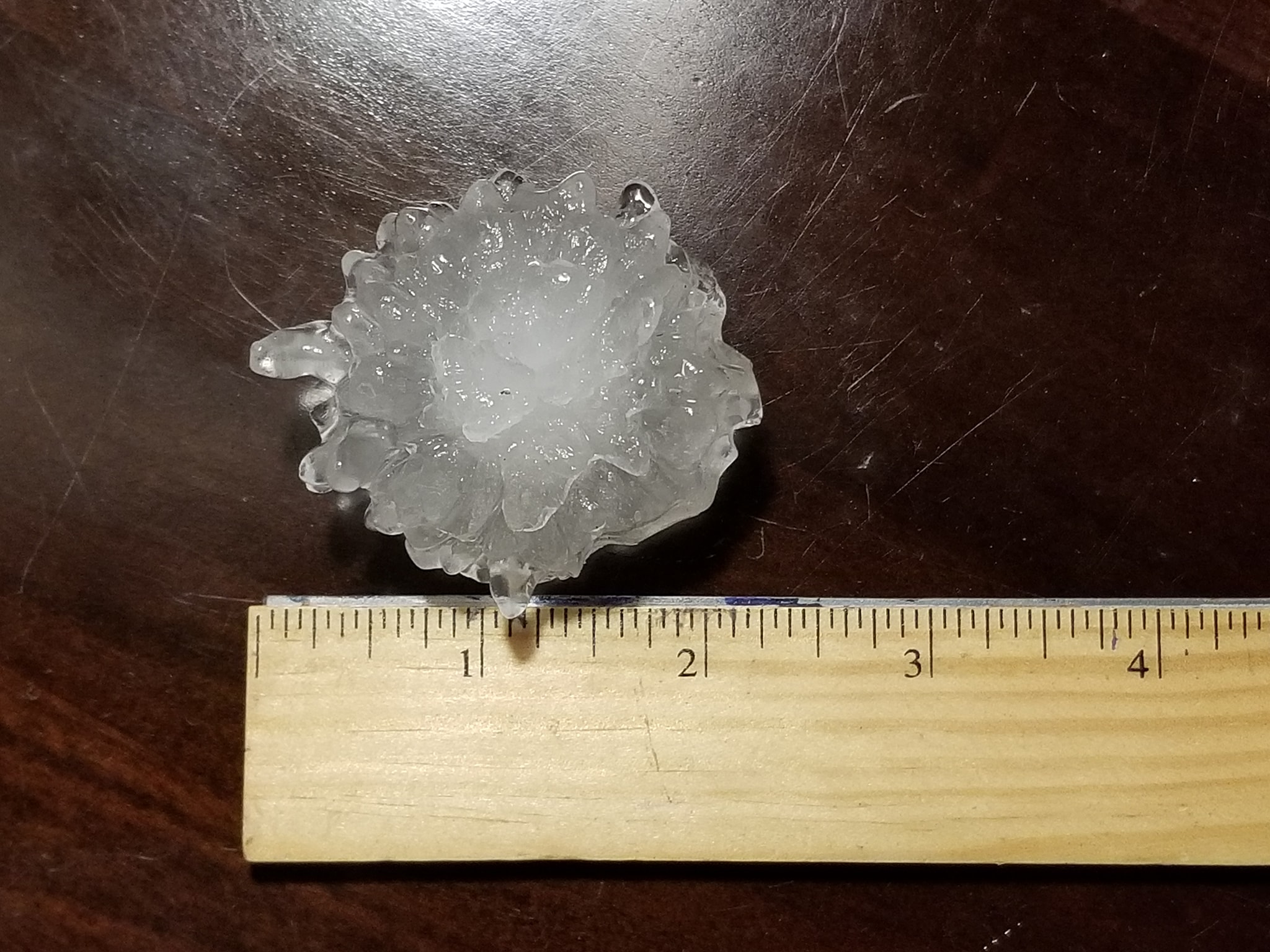 |
||
|
|
Midland Credit: Sarah Huss |
|
|
|
Radar
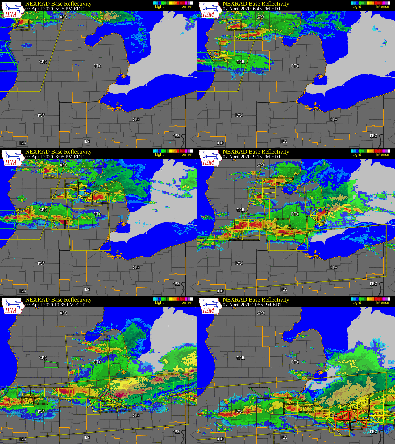  |
|
Click to Enlarge Radar loop courtesy of Iowa Environmental Mesonet (IEM) |
Storm Reports
Map of severe weather reports, with hail reports as green circles.
Severe Weather Local Storm Reports:
PRELIMINARY LOCAL STORM REPORT...SUMMARY
NATIONAL WEATHER SERVICE DETROIT/PONTIAC MI
519 AM EDT WED APR 8 2020

..TIME...   ...EVENT...      ...CITY LOCATION...     ...LAT.LON...
..DATE...   ....MAG....      ..COUNTY LOCATION..ST.. ...SOURCE....
            ..REMARKS..

0725 PM     HAIL             3 ESE EDENVILLE         43.78N 84.33W
04/07/2020  E1.75 INCH       MIDLAND            MI   TRAINED SPOTTER

0829 PM     HAIL             10 N LAPEER             43.19N 83.32W
04/07/2020  E1.50 INCH       LAPEER             MI   PUBLIC

            QUARTER TO PING PONG BALL SIZE HAIL. TIME BASED ON RADAR.


0832 PM     HAIL             NORTH BRANCH            43.23N 83.19W
04/07/2020  E2.00 INCH       LAPEER             MI   PUBLIC

            TIME ESTIMATED BASED ON RADAR.

0835 PM     HAIL             ATTICA                  43.03N 83.16W
04/07/2020  M1.50 INCH       LAPEER             MI   TRAINED SPOTTER

            HAIL COVERED THE GROUND AND DENTED THE ROOF OF A SHED.

0836 PM     HAIL             BROWN CITY              43.21N 82.99W
04/07/2020  E1.25 INCH       SANILAC            MI   PUBLIC

0837 PM     HAIL             1 NNW LUM               43.11N 83.16W
04/07/2020  M2.00 INCH       LAPEER             MI   PUBLIC

            1.75 TO 2.00 INCH HAIL

0839 PM     HAIL             4 NE LAPEER             43.09N 83.27W
04/07/2020  M1.00 INCH       LAPEER             MI   TRAINED SPOTTER

            REPORT ALONG SLATER ROAD.

0846 PM     HAIL             2 NW IMLAY CITY         43.04N 83.11W
04/07/2020  M1.75 INCH       LAPEER             MI   PUBLIC

            PING PONG BALL TO GOLF BALL SIZE HAIL

0850 PM     HAIL             PECK                    43.26N 82.82W
04/07/2020  E1.00 INCH       SANILAC            MI   911 CALL CENTER

            TIME BASED ON RADAR.

0850 PM     HAIL             MELVIN                  43.18N 82.86W
04/07/2020  E1.75 INCH       SANILAC            MI   PUBLIC

            TIME ESTIMATED ON RADAR

0850 PM     HAIL             PECK                    43.26N 82.82W
04/07/2020  E1.75 INCH       SANILAC            MI   PUBLIC

            QUARTER TO GOLF BALL SIZE HAIL

0852 PM     HAIL             YALE                    43.13N 82.80W
04/07/2020  M1.00 INCH       ST. CLAIR          MI   PUBLIC

0908 PM     HAIL             AVOCA                   43.06N 82.69W
04/07/2020  E1.00 INCH       ST. CLAIR          MI   TRAINED SPOTTER

0912 PM     MARINE TSTM WIND 1 NNE PORT HURON        43.01N 82.42W
04/07/2020  M40.00 MPH       ST. CLAIR          MI   BUOY

            MEASURED BY THE FORT GRATIOT BUOY.

0913 PM     HAIL             CHELSEA                 42.31N 84.02W
04/07/2020  M1.25 INCH       WASHTENAW          MI   PUBLIC

            PICTURED SHARED ON SOCIAL MEDIA WITH TIME ESTIMATED VIA
            RADAR

0914 PM     HAIL             6 WNW PORT HURON        43.01N 82.54W
04/07/2020  M1.00 INCH       ST. CLAIR          MI   TRAINED SPOTTER

            REPORT ALONG ATKINS ROAD.

0920 PM     HAIL             6 W ANN ARBOR           42.29N 83.84W
04/07/2020  E1.00 INCH       WASHTENAW          MI   911 CALL CENTER

0925 PM     HAIL             6 W ANN ARBOR           42.28N 83.85W
04/07/2020  E1.50 INCH       WASHTENAW          MI   TRAINED SPOTTER

0929 PM     HAIL             3 W GORDONVILLE         43.57N 84.44W
04/07/2020  M1.50 INCH       MIDLAND            MI   911 CALL CENTER

            NEAR THE INTERSECTION OF W STEWART ROAD AND S 8 MILE
            ROAD.

0929 PM     HAIL             1 N GORDONVILLE         43.58N 84.37W
04/07/2020  M2.00 INCH       MIDLAND            MI   PUBLIC

            1.75 TO 2.00 INCH HAIL 2 MILES SOUTH OF M-20 ON S
            MERIDIAN ROAD

0929 PM     HAIL             4 WSW MIDLAND           43.59N 84.30W
04/07/2020  M2.00 INCH       MIDLAND            MI   PUBLIC

            PHOTO SHARED VIA SOCIAL MEDIA NEAR THE INTERSECTION OF
            EAST MILLER ROAD AND SOUTH WOODCOCK ROAD.

0936 PM     HAIL             MIDLAND                 43.62N 84.23W
04/07/2020  M1.00 INCH       MIDLAND            MI   TRAINED SPOTTER

0937 PM     HAIL             5 WNW FREELAND          43.54N 84.21W
04/07/2020  M1.50 INCH       MIDLAND            MI   PUBLIC

            HALF DOLLAR TO PING PONG BALL SIZE HAIL.

0938 PM     HAIL             1 S SALINE              42.16N 83.78W
04/07/2020  E1.00 INCH       WASHTENAW          MI   TRAINED SPOTTER

            MOSTLY NICKEL SIZE HAIL WITH SOME QUARTER SIZE HAIL

0942 PM     HAIL             3 SSE MIDLAND           43.58N 84.21W
04/07/2020  M1.00 INCH       MIDLAND            MI   PUBLIC

            NEAR THE INTERSECTION OF SALZBURG AND S SAGINAW ROAD.

1002 PM     HAIL             BAY CITY                43.59N 83.89W
04/07/2020  M1.75 INCH       BAY                MI   TRAINED SPOTTER

            GOLF BALL HAIL NEAR INTERSECTION OF 14TH AND SOUTH
            HAMPTON

1058 PM     HAIL             MORENCI                 41.72N 84.22W
04/07/2020  M1.50 INCH       LENAWEE            MI   PUBLIC

            PICTURE SHARED ON SOCIAL MEDIA


&&
National Storm Reports (for April 7, 2020):
Environment
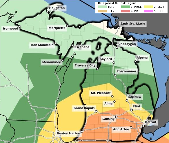
The April 7, 2020 severe weather event was the first of the 2020 season. It also occurred in a notably favorable early spring thermodynamic, dynamic, and kinematic environment. The juxtaposition of these 3 key features, along with a northward surge in low-level moisture, was the mechanism for the numerous severe thunderstorms that occurred roughly between 7pm and 11pm EDT. The weather pattern was so favorable for severe weather that the Storm Prediction Center (SPC) included most areas south of the I-69 corridor in an Enhanced Risk for severe thunderstorms (Fig. 1).
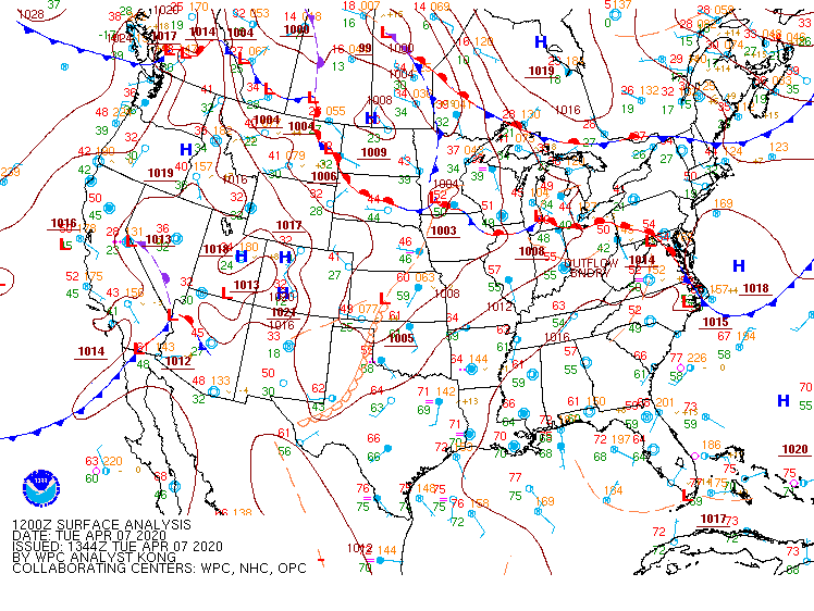
For most, the morning of the event would have yielded little interest in potential severe weather. Exiting showers with a few rumbles of thunder gave way to cool and damp conditions under a thick stratus deck. However, this weather was to be short-lived as a warm front draped along the Ohio border (Fig. 2) quickly surged northward towards the I-69 corridor heading into the afternoon hours on the heels of increasing southerly low-level flow (Fig. 3). Areas north of the warm front that were only in the 40s quickly jumped well into the 60s and even low 70s in spots signifying just how strong the temperature gradient along the warm frontal boundary was. South of the warm front also saw dewpoints surge well into the 50s and even low 60s in spots; on the higher end for early April.
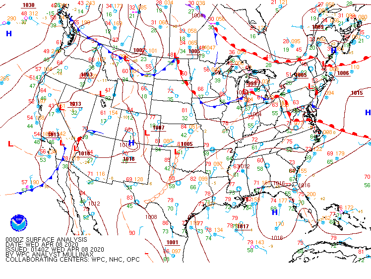
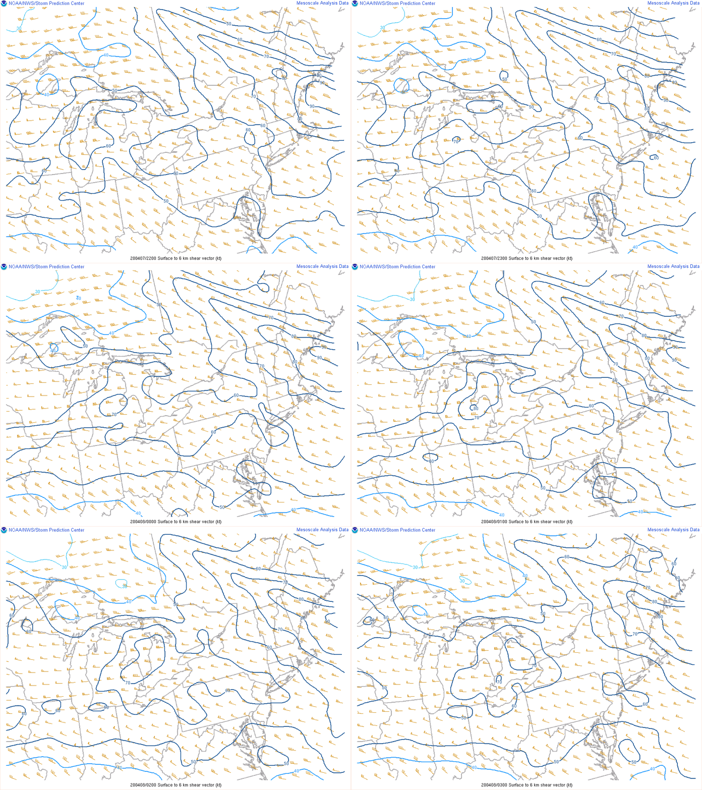
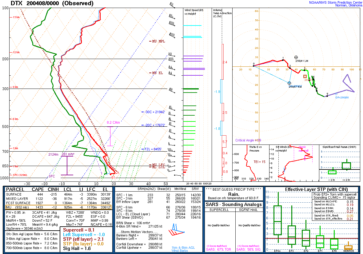
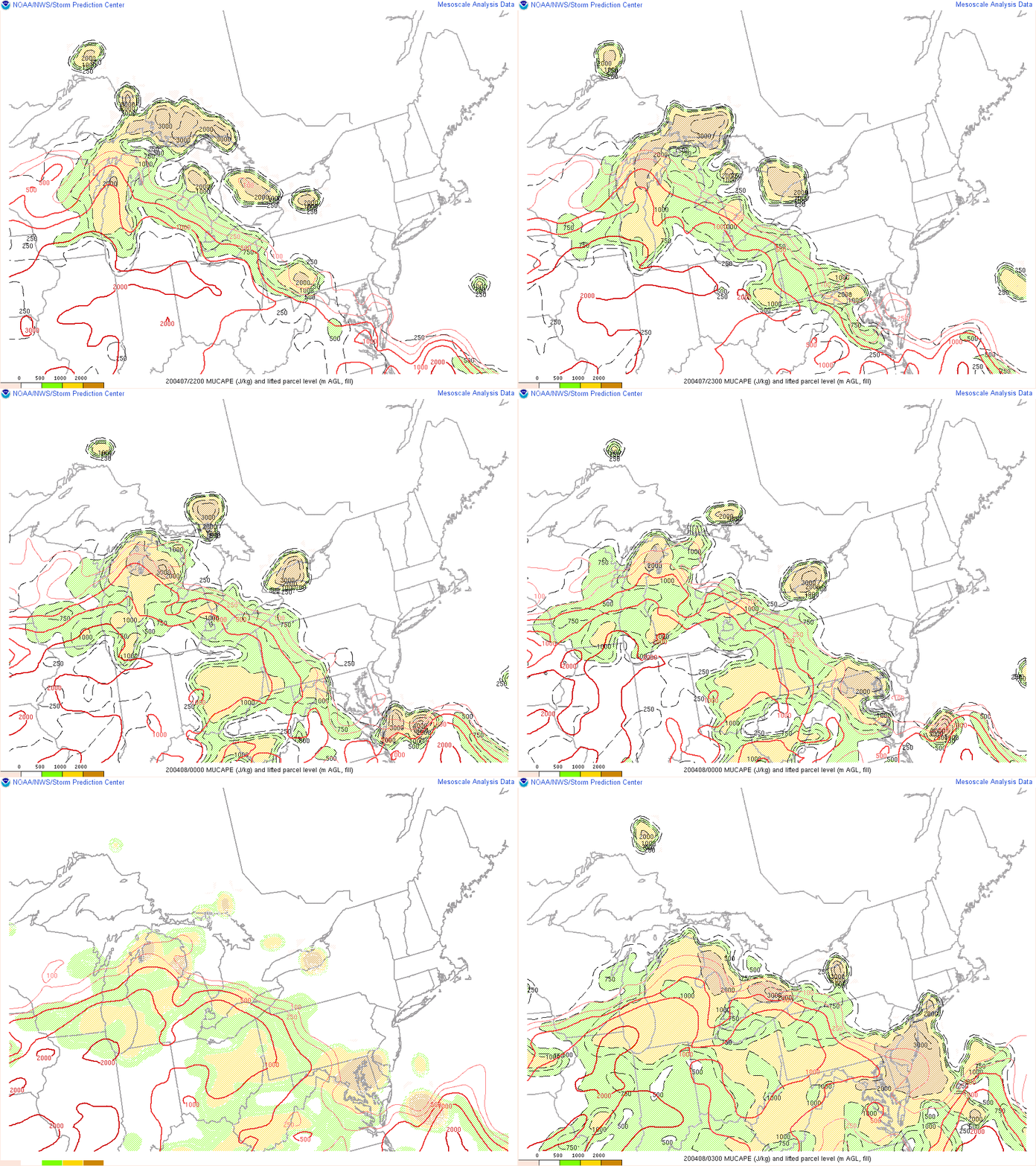
In addition to the warm front placement across the region, additional dynamic support was in place heading into the evening hours with the arrival of a weak surface low and its attendant stronger mid/upper-level wave (Fig. 4). These features provided the background support for large-scale lift across the region. However, it was the overlaying of 3 key environmental variables that set the stage for the multiple reports of large hail across the region. The first was the presence of strong deep layer wind shear in excess of 50 knots (Fig. 5), which enabled initial storm development of supercellular structures before growing upscale into multicell clusters with embedded bowing segments. In fact, the 00 UTC KDTX observed sounding that was launched just before broader convective initiation revealed a 0-6 km wind shear value approaching an impressive 70 knots (Fig. 6). The second key environmental variable was the presence of sufficient instability, both near the surface and aloft. With the “warm sector” (areas south of the warm front) encompassing much of the region, most unstable parcel CAPE values (MUCAPE) on the order of 1000-2000 J/kg were able to be achieved (Fig. 7). The final key environmental variable, which ended up proving to be most important for the numerous large hail reports across the region, was the presence of steep mid-level lapse rates. These lapse rates occurred largely in part as a result of a residual elevated mixed layer (EML) moving across the lower Great Lakes during the late day/early overnight period. SPC mesoanalysis revealed 700-500 hPa lapse rates on the order of 7-8° C/km during the evening hours (Fig. 8). Even during the morning hours, it was evident that the severe weather threat was materializing as the 12 UTC KDVN observed sounding revealed around 8° C/km (not shown).
Several Severe Thunderstorm Warnings were issued throughout the event. There were two areas of the region hit particularly hard during the event. The first stretched from the Tri-Cities southeast into southern portions of the Thumb. The second occurred mainly across a stretch that included Livingston, Washtenaw, Lenawee, Monroe, and portions of Wayne counties. Regardless, most areas at a minimum saw rain and an impressive lightning show. At times, some thunderstorms also exhibited rotation although there were no confirmed reports of funnel clouds or tornadoes. The main severe weather report was large hail, with some locations seeing up to golf ball size. Many other locations saw dime to quarter size hail.
Click on the images below to see them expanded.
 |
 |
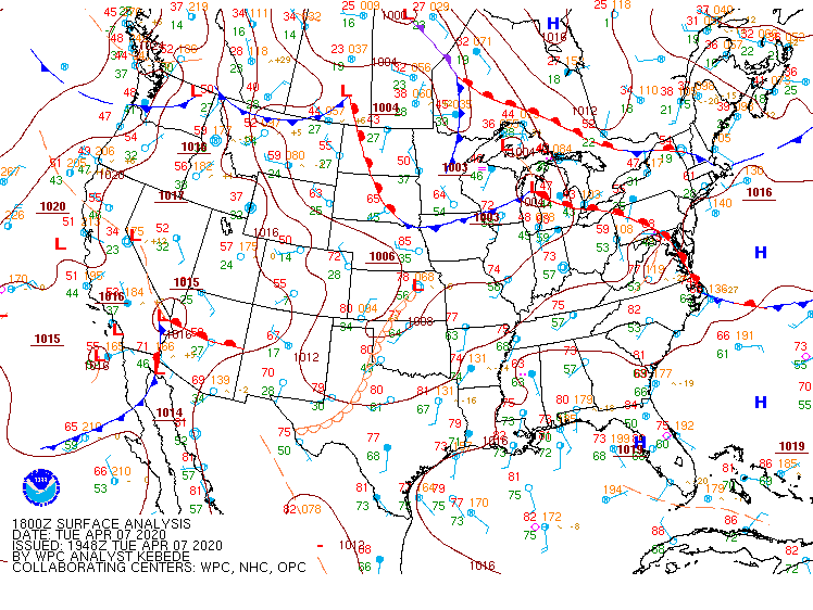 |
| Figure 1: Storm Prediction Center Day 1 Convective Outlook, valid 12 UTC 7 April 2020. | Figure 2: Weather Prediction Center (WPC) surface map, valid 12 UTC 7 April 2020. | Figure 3: WPC surface map, valid 18 UTC 7 April 2020. |
 |
 |
|
| Figure 4: WPC surface map, valid 00 UTC 8 April 2020. | Figure 5: Loop of 0-6 km bulk shear, valid 22 UTC 7 April 2020 to 03 UTC 8 April 2020. | |
 |
 |
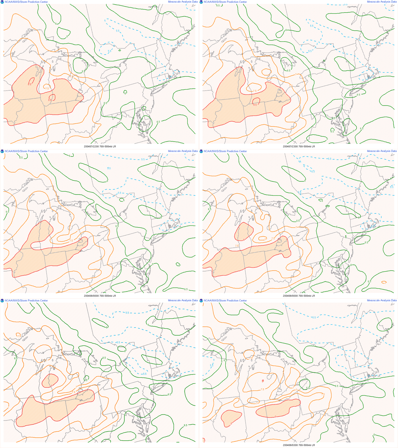 |
| Figure 6: KDTX observed sounding, valid 00 UTC 8 April 2020. | Figure 7: Loop of MUCAPE, valid 22 UTC 7 April 2020 to 03 UTC 8 April 2020. | Figure 8: Loop of 700-500 hPa lapse rates, valid 22 UTC 7 April 2020 to 03 UTC 8 April 2020. |
 |
Media use of NWS Web News Stories is encouraged! Please acknowledge the NWS as the source of any news information accessed from this site. |
 |