Overview
A cold front tracked across Southeast Michigan on October 7th, between 9 PM - 12 AM, producing fast-moving severe thunderstorms spanning numerous counties. The main threat with all the severe thunderstorms was damaging wind gusts, as strong winds aloft were brought to the surface by the storms, amplified by the forward speed of the storms themselves. Local storm reports consisted of downed trees and tree limbs, downed power lines, and building damage. Additionally, rotation seen on Doppler radar was responsible for two tornado warnings, for both Livingston and Lapeer Counties. A tornado has not been confirmed at this time, however, multiple accounts of downed trees were reported within the warned areas.
Local Storm Report & Warning Map
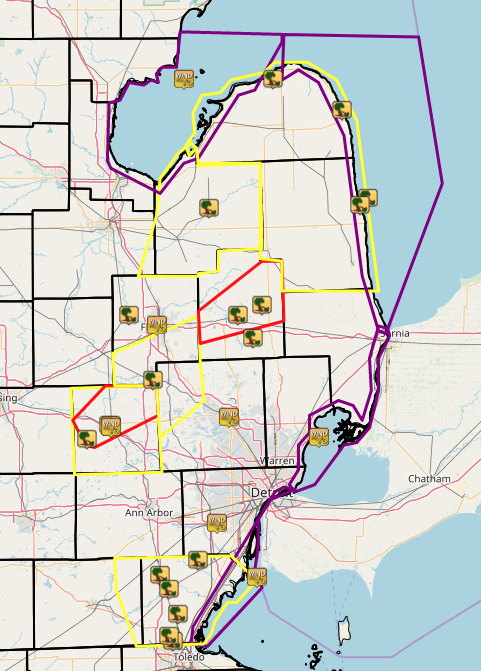 |
| Map of Severe Thunderstorm Warnings (yellow), Tornado Warnings (red), Special Marine Warnings (purple) and associated wind gust and thunderstorm wind damage reports. |
Radar
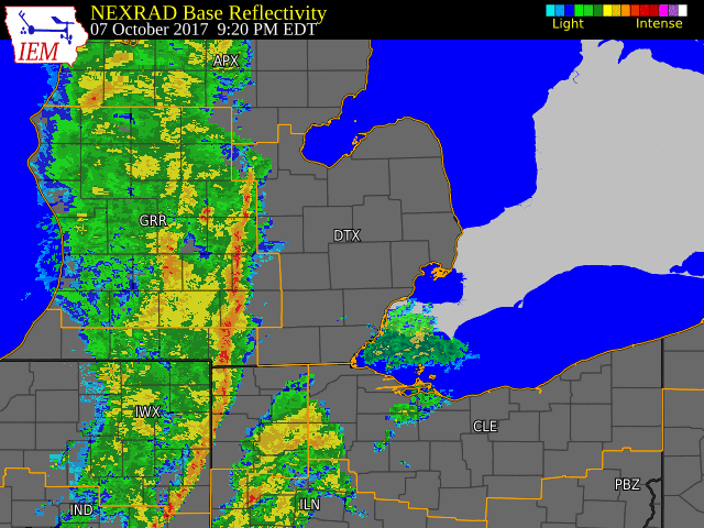 |
| Radar loop courtesy of Iowa Environmental Mesonet (IEM) |
Storm Reports
PRELIMINARY LOCAL STORM REPORT...SUMMARY
NATIONAL WEATHER SERVICE DETROIT/PONTIAC MI
1125 AM EDT SUN OCT 08 2017

..TIME...   ...EVENT...      ...CITY LOCATION...     ...LAT.LON...
..DATE...   ....MAG....      ..COUNTY LOCATION..ST.. ...SOURCE....
            ..REMARKS..

1000 PM     TSTM WND DMG     7 S FOWLERVILLE         42.56N 84.07W
10/07/2017                   LIVINGSTON         MI   PUBLIC

            TREES BLOCKING MUNSELL ROAD EAST OF ASTORIA DRIVE. SIDING
            RIPPED OFF THE SOUTH SIDE OF HOME.

1006 PM     TSTM WND DMG     1 NW HOWELL             42.62N 83.95W
10/07/2017                   LIVINGSTON         MI   TRAINED SPOTTER

            15 INCH TREE LIMBS DOWN WITH SEVERAL 3 TO 4 INCH LIMBS
            DOWN AT BREWER ROAD AND M-59. REPORTED 57 MPH WIND GUST
            WITH ANEMOMETER NEAR THIS LOCATION.

1008 PM     TSTM WND DMG     FLUSHING                43.06N 83.84W
10/07/2017                   GENESEE            MI   PUBLIC

            TREE DOWN ON HOUSE.

1010 PM     TSTM WND DMG     1 N HOWELL              42.62N 83.94W
10/07/2017                   LIVINGSTON         MI   TRAINED SPOTTER

            MULTIPLE TREES DOWN ON HENDERSON ROAD NEAR BYRON ROAD.

1023 PM     TSTM WND DMG     FENTON                  42.80N 83.71W
10/07/2017                   GENESEE            MI   PUBLIC

            LARGE TREE DOWN ON WHITE LAKE ROAD.

1036 PM     TSTM WND DMG     2 SW TEMPERANCE         41.74N 83.60W
10/07/2017                   MONROE             MI   LAW ENFORCEMENT

            MONROE COUNTY CENTRAL DISPATCH REPORTED TREE DOWN AT
            DOUGLAS RD AND STERNS RD.

1037 PM     TSTM WND DMG     4 N DUNDEE              42.01N 83.67W
10/07/2017                   MONROE             MI   LAW ENFORCEMENT

            MONROE COUNTY CENTRAL DISPATCH REPORTED TREE DOWN AT ANN
            ARBOR RD AND MILWAUKEE RD.

1037 PM     TSTM WND DMG     3 WSW TEMPERANCE        41.76N 83.62W
10/07/2017                   MONROE             MI   LAW ENFORCEMENT

            MONROE COUNTY CENTRAL DISPATCH REPORTED TREE DOWN AT
            WATERFORD AND DEAN RD.

1039 PM     TSTM WND DMG     2 ESE DUNDEE            41.95N 83.62W
10/07/2017                   MONROE             MI   LAW ENFORCEMENT

            MONROE COUNTY CENTRAL DISPATCH REPORTED TREE DOWN AT
            MEANWELL RD AND M-50.

1040 PM     MARINE TSTM WIND 8 ESE AU GRES           44.00N 83.54W
10/07/2017  M48.00 MPH       LHZ421             MI   BUOY

            OBSERVATION AT GRAVELLY SHOALS BUOY

1042 PM     TSTM WND DMG     6 N TEMPERANCE          41.85N 83.57W
10/07/2017                   MONROE             MI   LAW ENFORCEMENT

            MONROE COUNTY CENTRAL DISPATCH REPORTED TREE DOWN AT TODD
            RD AND LEWIS AVE.

1046 PM     TSTM WND DMG     CARO                    43.49N 83.40W
10/07/2017                   TUSCOLA            MI   LAW ENFORCEMENT

            TUSCOLA COUNTY CENTRAL DISPATCH REPORTED THAT THERE ARE
            NUMEROUS TREES AND POWER LINES DOWN THROUGHOUT THE
            COUNTY.

1052 PM     TSTM WND DMG     4 WNW CARLETON          42.07N 83.46W
10/07/2017                   MONROE             MI   LAW ENFORCEMENT

            MONROE COUNTY CENTRAL DISPATCH REPORTED TREE DOWN AT
            MARTINSVILLE RD AND COLF RD.

1056 PM     TSTM WND DMG     5 SW IMLAY CITY         42.97N 83.16W
10/07/2017                   LAPEER             MI   LAW ENFORCEMENT

            LAPEER COUNTY CENTRAL DISPATCH REPORTED TREE DOWN AT LAKE
            PLEASANT RD AND SUTTON RD.

1056 PM     TSTM WND DMG     4 ENE LAPEER            43.06N 83.24W
10/07/2017                   LAPEER             MI   LAW ENFORCEMENT

            LAPEER COUNTY CENTRAL DISPATCH REPORTED TREE FALLEN ONTO
            POWER LINES ON CORNELL DR.

1105 PM     TSTM WND DMG     2 E LUM                 43.10N 83.11W
10/07/2017                   LAPEER             MI   LAW ENFORCEMENT

            LAPEER COUNTY CENTRAL DISPATCH REPORTED TREE DOWN AT LUM
            RD AND SUMMERS RD.

1109 PM     TSTM WND DMG     4 SW PORT AUSTIN        44.00N 83.05W
10/07/2017                   HURON              MI   LAW ENFORCEMENT

            HURON COUNTY CENTRAL DISPATCH REPORTED TREE DOWN ON PORT
            CRESCENT RD.

1114 PM     MARINE TSTM WIND 5 E ESTRAL BEACH        42.00N 83.14W
10/07/2017  M57.00 MPH       LEZ444             MI   C-MAN STATION

            OBSERVATION AT THE DETROIT RIVER LIGHT

1132 PM     TSTM WND DMG     2 NNW HARBOR BEACH      43.88N 82.67W
10/07/2017                   HURON              MI   LAW ENFORCEMENT

            HURON COUNTY CENTRAL DISPATCH REPORTED TREE DOWN AT OLD
            SHORE AND MINNICK RD.

1140 PM     TSTM WND DMG     FORESTER                43.50N 82.57W
10/07/2017                   SANILAC            MI   LAW ENFORCEMENT

            SANILAC COUNTY CENTRAL DISPATCH REPORTED TREES DOWN ALONG
            M25 IN FORESTER TOWNSHIP.

1155 PM     TSTM WND GST     5 ESE MOUNT CLEMENS     42.57N 82.80W
10/07/2017  M50.00 MPH       MACOMB             MI   PARK/FOREST SRVC

            OBSERVATION AT LAKE ST. CLAIR METROPARK
Environment
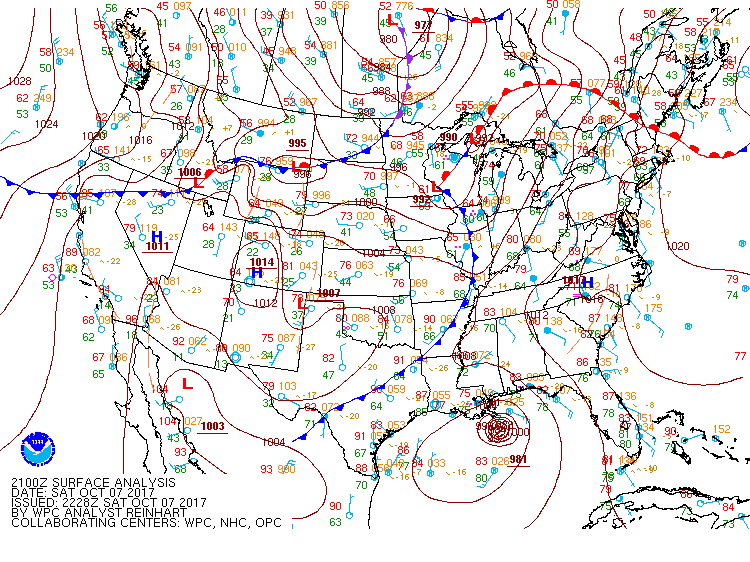
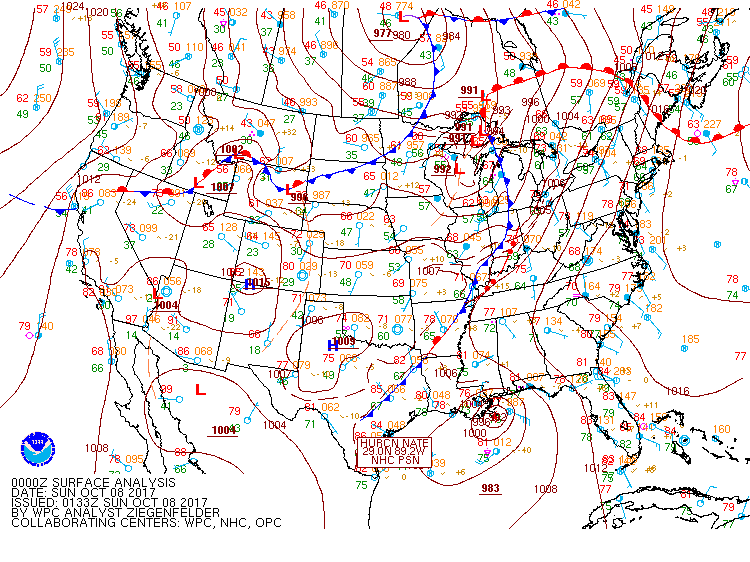
Surface Maps: Progression of cold front through Michigan
 |
 |
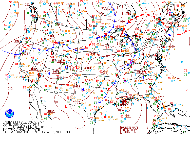 |
| Surface Fronts/Surface Pressure 5 PM | Surface Fronts/Surface Pressure 8 PM | Surface Fronts/Surface Pressure 11 PM |
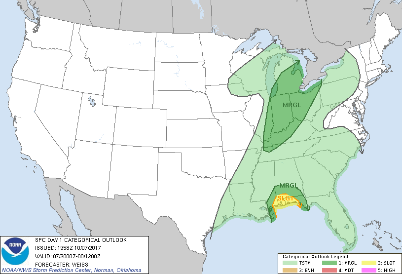
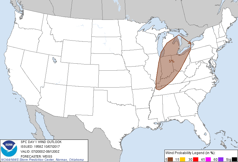
SPC Outlooks
 |
 |
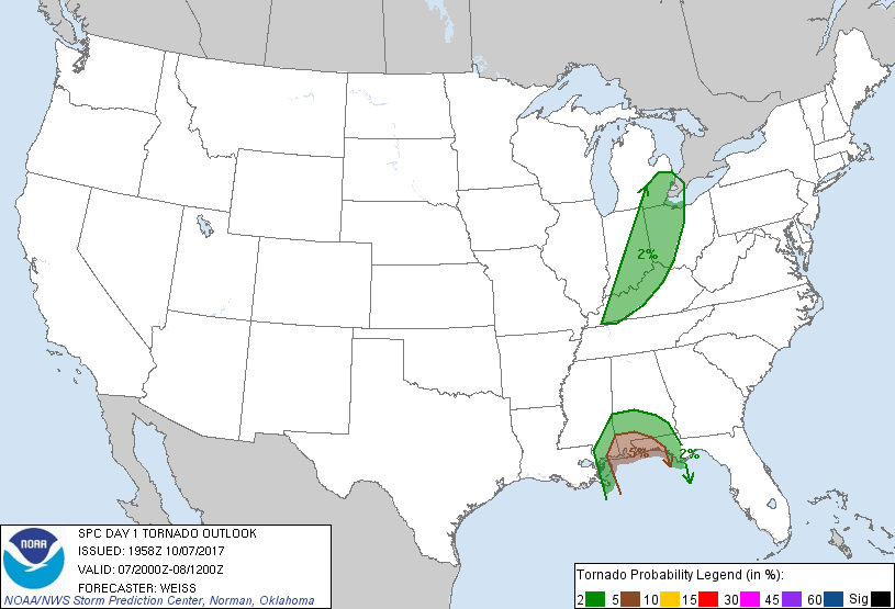 |
| SPC Day 1 Outlook: Risk Category | SPC Day 1 Outlook: Damaging Winds | SPC Day 1 Outlook: Tornado |
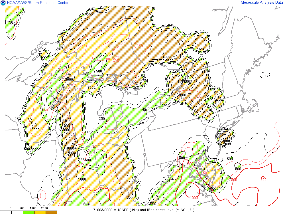
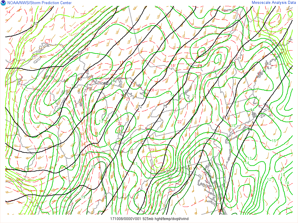
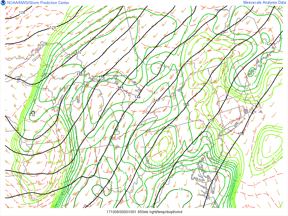
Additional Environmental Parameters: Despite limited instability (CAPE) in SE Michigan, the convection that developed was able to tap into the strong winds located just above the surface - 40 kt at 925 mb (~1200 ft above the surface), 45 kt at 850 mb (~3500 ft above the surface), and 50 kt at 700 mb (~8900 ft above the surface) - and bring these winds to the surface as damaging gusts.
 |
 |
 |
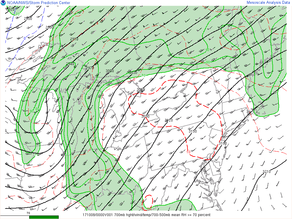 |
| SPC Analysis: Most Unstable CAPE | SPC Analysis: 925 mb Level | SPC Analysis: 850 mb Level | SPC Analysis: 700 mb Level |
 |
Media use of NWS Web News Stories is encouraged! Please acknowledge the NWS as the source of any news information accessed from this site. |
|

