Overview
After several weeks of moderate to severe drought conditions in Southeast Michigan, an active weather pattern brought widespread rainfall and flooding to Metro Detroit and surrounding areas during the weekend of June 25-27th. Low pressure tracking along a stalled stationary boundary interacted with a very moist subtropical air mass to produce widespread 3 to 5 inches of rainfall across Metro Detroit (localized 6 to 8 inches), resulting in numerous reports of major flooding within the Detroit metro vicinity, especially Washtenaw and Wayne County. The heavy rain was coupled with a severe weather threat, in which a line of severe thunderstorms moved through Southeast Michigan late afternoon to early evening June 26th. The main threats with these storms were torrential downpours, damaging wind, and an isolated tornado threat. An EF-2 tornado was observed near Port Austin in Huron County during this event just before 6 pm on June 26th.
Tornado Information:
|
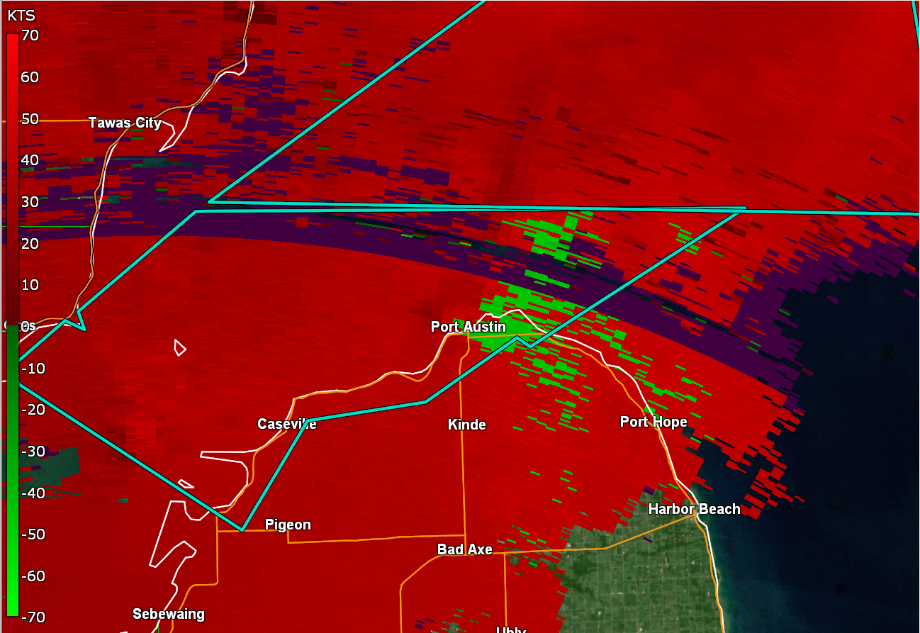
Tornado - Port Austin, MI
Track Map  
Radar Images at 5:54 PM EDT Bottom Image: Inbound velocities (green) located next to outbound velocities (red)
|
||||||||||||||||
The Enhanced Fujita (EF) Scale classifies tornadoes into the following categories:
| EF0 Weak 65-85 mph |
EF1 Moderate 86-110 mph |
EF2 Significant 111-135 mph |
EF3 Severe 136-165 mph |
EF4 Extreme 166-200 mph |
EF5 Catastrophic 200+ mph |
 |
|||||
Photos & Local Media Coverage
 |
 |
 |
|
Flooding in Metro Detroit Credit: Karen Drew |
Flooding on Southfield Freeway Credit: Jenn Schanz |
Flooding on I-94 Credit: Michigan State Police |
 |
 |
 |
|
Flooding on I-94 Credit: Jennifer Ann Wilson |
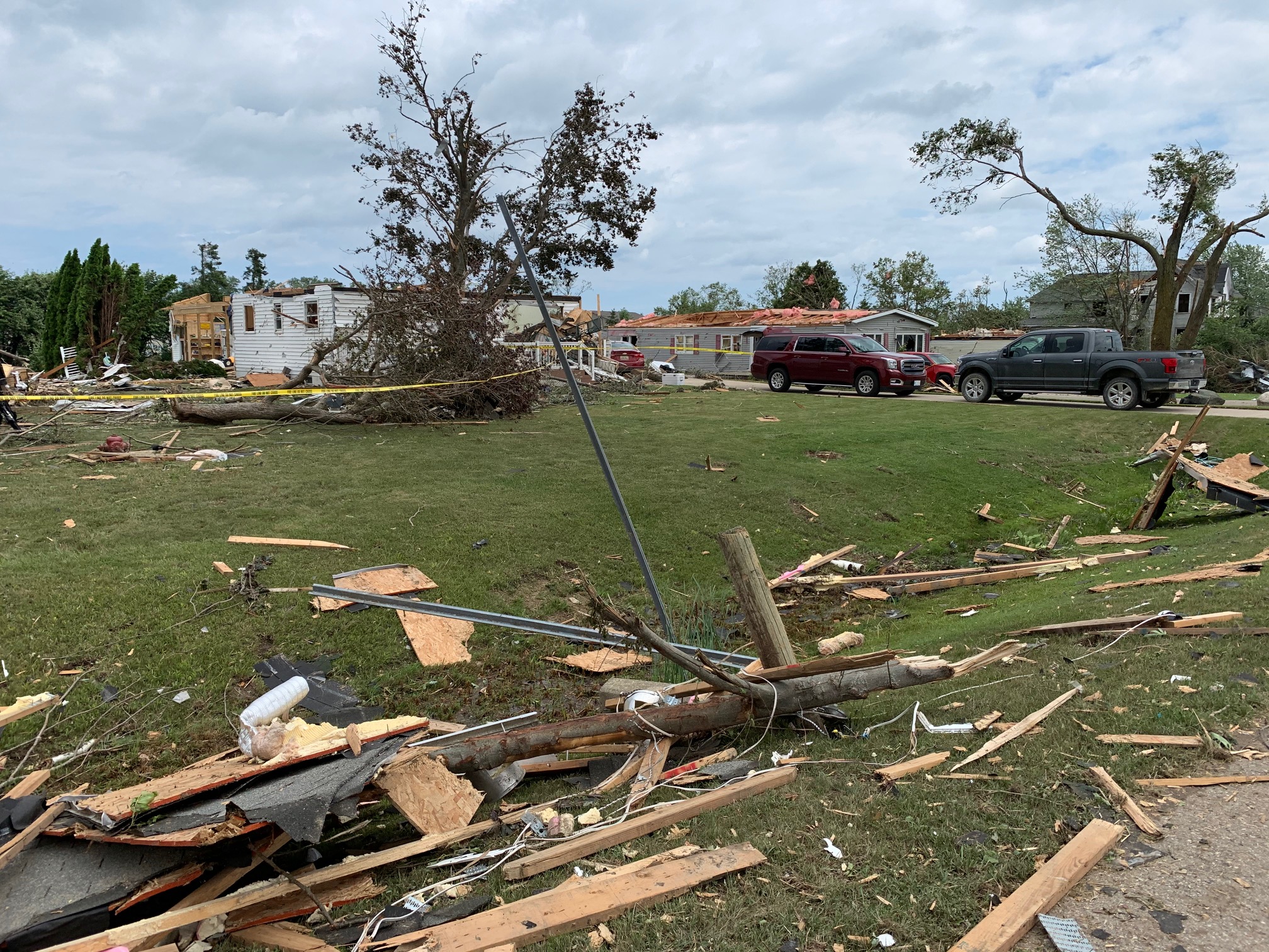
Tornado Damage in Port Austin Credit: NWS Storm Survey |
Tornado Damage in Port Austin Credit: Jimmy Kish |
 |
 |
|
Uprooted Tree in Port Austin Credit: WNEM |
Flooded Street in Ann Arbor Credit: Joshua Neyhart |
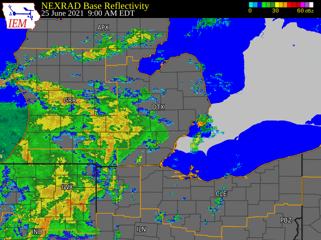
Radar
|
Radar imagery for Jun 25-26, 2021 flooding
Radar imagery for severe weather on June 26, 2021 |
 |
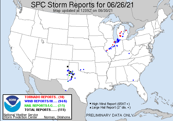
Storm Reports
Public Information Statement
National Weather Service Detroit/Pontiac MI
615 PM EDT Mon Jun 28 2021

...PUBLIC INFORMATION STATEMENT...

...3 DAY PRECIPITATION TOTAL REPORTS...

Location                     Amount    Time/Date       Lat/Lon

...Michigan...

...Bay County...
3.3 E Auburn                 3.75 in   0630 AM 06/28   43.63N/84.02W
Auburn                       2.92 in   0300 PM 06/28   43.60N/84.10W
Bay City                     2.02 in   0300 PM 06/28   43.69N/83.92W

...Genesee County...
3.4 SE Genesee               3.27 in   0700 AM 06/28   43.07N/83.59W
Davison 3.4 NNW              3.12 in   0800 AM 06/28   43.08N/83.55W
Grand Blanc 2.9 SE           3.09 in   0700 AM 06/28   42.89N/83.59W
Goodrich                     2.99 in   0730 AM 06/28   42.92N/83.51W
Linden                       2.89 in   0700 AM 06/28   42.81N/83.80W
Swartz Creek 1.1 N           2.76 in   0700 AM 06/28   42.98N/83.83W
Davison 5.2 N                2.47 in   0900 AM 06/28   43.11N/83.51W
1 SW Fenton                  2.19 in   0305 PM 06/28   42.79N/83.73W
Flint 7W                     2.17 in   0800 AM 06/26   43.04N/83.77W
Flint (KFNT)                 2.11 in   0253 PM 06/28   42.97N/83.75W
Swartz Creek                 1.87 in   0305 PM 06/28   42.96N/83.86W
Linden                       1.73 in   0300 PM 06/28   42.81N/83.80W

...Huron County...
Bad Axe 0.5 SSW              2.27 in   0830 AM 06/28   43.80N/83.00W
Bad Axe 6.3 SSW              2.17 in   1100 AM 06/28   43.72N/83.06W
Bad Axe                      1.85 in   0640 AM 06/28   43.82N/83.00W
Caseville                    1.62 in   0309 PM 06/28   43.91N/83.38W
0.8 SE Pinnebog              1.58 in   0630 AM 06/28   43.93N/83.09W
Port Hope (KP58)             1.45 in   0255 PM 06/28   44.02N/82.80W
3 E Elkton                   1.19 in   0300 PM 06/28   43.81N/83.10W

...Lapeer County...
1.2 NW Lapeer                1.77 in   0700 AM 06/28   43.06N/83.33W
Lapeer (KD95)                1.50 in   0255 PM 06/28   43.07N/83.27W

...Lenawee County...
2.2 NW Tipton                2.04 in   0745 AM 06/28   42.03N/84.10W
Clinton 0.5 NE               1.96 in   0600 AM 06/28   42.08N/83.97W
0.5 SW Tecumseh              1.19 in   0630 AM 06/28   42.00N/83.95W
Blissfield 1.2 WNW           1.15 in   0800 AM 06/28   41.84N/83.88W
Morenci                      1.14 in   0730 AM 06/28   41.72N/84.20W
Adrian                       0.99 in   0234 PM 06/28   41.91N/84.08W
Adrian                       0.84 in   0253 PM 06/28   41.87N/84.08W
Adrian (KADG)                0.84 in   0306 PM 06/28   41.91N/84.02W

...Livingston County...
Howell 4.9 ESE               3.20 in   0700 AM 06/28   42.58N/83.85W
Fenton 6.2 WSW               2.92 in   0800 AM 06/28   42.77N/83.83W
South Lyon 2.6 SW            2.58 in   0700 AM 06/28   42.43N/83.69W
Pinckney                     2.31 in   0301 PM 06/28   42.48N/84.00W
Howell (KOZW)                2.25 in   0255 PM 06/28   42.62N/83.97W
Brighton 1.5 ENE             2.23 in   0800 AM 06/28   42.54N/83.76W
Fenton 5.6 WSW               2.16 in   0800 AM 06/28   42.77N/83.82W
Brighton                     1.97 in   0308 PM 06/28   42.57N/83.78W
Pinckney 5.4 E               1.69 in   0800 AM 06/28   42.46N/83.84W
Howell                       1.64 in   0309 PM 06/28   42.59N/84.00W
Brighton                     1.32 in   0309 PM 06/28   42.52N/83.79W

...Macomb County...
Richmond 4 NNW               4.36 in   0800 AM 06/27   42.88N/82.80W
Shelby 2.6 SW                3.84 in   0655 AM 06/28   42.64N/83.07W
Sterling Heights             3.62 in   0300 PM 06/28   42.74N/83.00W
Roseville 1.7 ENE            2.62 in   0500 AM 06/28   42.51N/82.90W
Sterling Heights             2.33 in   0306 PM 06/28   42.79N/83.02W
Chesterfield 2.4 E           2.18 in   0640 AM 06/28   42.67N/82.79W
Clinton 2.3 N                2.17 in   0700 AM 06/28   42.62N/82.92W
Detroit                      2.16 in   0306 PM 06/28   42.52N/82.88W
1.4 W Mount Clemens          2.13 in   0800 AM 06/28   42.60N/82.91W
Fraser 1.2 N                 1.96 in   0700 AM 06/28   42.56N/82.95W
Warren                       1.57 in   0309 PM 06/28   42.51N/83.00W
2 SW Fraser                  1.38 in   0305 PM 06/28   42.52N/82.97W

...Midland County...
0.8 SE Midland               3.02 in   0800 AM 06/28   43.62N/84.22W
Bay City                     2.02 in   0310 PM 06/28   43.62N/84.24W

...Monroe County...
Ottawa Lake 1.4 SSW          1.23 in   0700 AM 06/28   41.78N/83.74W
Monroe 3.0 S                 1.16 in   0700 AM 06/28   41.87N/83.38W
3 SE Maybee                  0.85 in   0730 AM 06/28   41.97N/83.48W
0.7 SE Dundee                0.75 in   0700 AM 06/28   41.95N/83.65W
Carleton 2.5 S               0.68 in   0800 AM 06/28   42.02N/83.39W
2 NNW Lambertville           0.51 in   0300 PM 06/28   41.78N/83.64W
Monroe (KTTF)                0.48 in   0255 PM 06/28   41.93N/83.42W

...Oakland County...
Bloomfield Township 3.1 SW   4.39 in   0700 AM 06/28   42.55N/83.32W
Franklin                     4.34 in   0300 PM 06/28   42.52N/83.32W
Bloomfield Hills             4.11 in   0310 PM 06/28   42.62N/83.22W
Davisburg 1.3 ESE            4.01 in   0800 AM 06/28   42.74N/83.52W
Fenton 2.7 SSE               3.79 in   0800 AM 06/28   42.77N/83.69W
0.6 E Farmington             3.53 in   0730 AM 06/28   42.47N/83.37W
Farmington Hills 2.4 SSW     3.44 in   0700 AM 06/28   42.46N/83.40W
Rochester Hills 1.6 NNW      3.15 in   0700 AM 06/28   42.69N/83.17W
Pleasant Ridge 0.5 WNW       3.05 in   0800 AM 06/28   42.47N/83.15W
Clarkston 1.4 NE             2.99 in   0700 AM 06/28   42.75N/83.40W
Berkley 0.6 N                2.97 in   0600 AM 06/28   42.51N/83.19W
Troy 1.8 S                   2.95 in   0700 AM 06/28   42.55N/83.14W
Southfield 2.8 NNE           2.90 in   0800 AM 06/28   42.51N/83.24W
Novi                         2.77 in   0302 PM 06/28   42.45N/83.45W
Holly                        2.73 in   0201 PM 06/28   42.82N/83.68W
Oakland                      2.72 in   0309 PM 06/28   42.72N/83.15W
Rochester Hills              2.65 in   0305 PM 06/28   42.66N/83.13W
Beverly Hills                2.53 in   0300 PM 06/28   42.52N/83.26W
White Lake 0.5 E             2.42 in   0920 AM 06/28   42.69N/83.55W
Lake Orion 4.3 SSE           2.35 in   0700 AM 06/28   42.72N/83.23W
West Bloomfield              2.06 in   0309 PM 06/28   42.58N/83.41W
Waterford 3.5 SSE            2.04 in   0900 AM 06/28   42.62N/83.37W
Milford Township             2.03 in   0307 PM 06/28   42.58N/83.65W
Leonard                      2.02 in   0309 PM 06/28   42.87N/83.16W
Wixom 2.0 NNW                1.94 in   0700 AM 06/28   42.55N/83.55W
Lake Orion 1.1 ENE           1.93 in   0600 AM 06/28   42.79N/83.22W
Waterford 2.6 N              1.83 in   0800 AM 06/28   42.70N/83.39W
Milford 4.3 ESE              1.75 in   0730 AM 06/28   42.57N/83.52W
1 ENE Orchard Lake           1.72 in   0305 PM 06/28   42.59N/83.34W
West Bloomfield              1.64 in   0309 PM 06/28   42.56N/83.39W
Commerce                     1.47 in   0307 PM 06/28   42.55N/83.50W
Oxford                       1.46 in   0306 PM 06/28   42.82N/83.25W
Ortonville                   1.38 in   0300 PM 06/28   42.85N/83.41W
Pontiac (KPTK)               1.24 in   0253 PM 06/28   42.67N/83.42W
Ortonville 2.3 S             1.18 in   0700 AM 06/28   42.82N/83.44W
Commerce Township            1.14 in   0310 PM 06/28   42.59N/83.51W
2.1 NE Fenton                1.01 in   0301 PM 06/28   42.82N/83.68W
Milford                      1.00 in   0307 PM 06/28   42.56N/83.65W

...Saginaw County...
2 SSW Nelson                 5.11 in   0800 AM 06/28   43.30N/84.25W
3 WNW Shields                3.50 in   0800 AM 06/27   43.43N/84.12W
1.4 SE Frankenmuth           3.28 in   0910 AM 06/28   43.32N/83.72W
Saginaw 6.4 W                3.26 in   0900 AM 06/28   43.42N/84.08W
Saginaw 8 NW                 2.48 in   0730 AM 06/28   43.50N/84.10W
Saginaw (KMBS)               1.59 in   0253 PM 06/28   43.53N/84.08W
Frankenmuth                  1.36 in   0300 PM 06/28   43.33N/83.74W

...Sanilac County...
Lexington                    3.20 in   0720 AM 06/28   43.26N/82.53W
Marlette                     1.89 in   0308 PM 06/28   43.30N/83.10W
Melvin                       1.04 in   0230 PM 06/28   43.18N/82.86W

...Shiawassee County...
1.0 N Durand                 3.84 in   0800 AM 06/28   42.93N/83.99W
Owosso                       3.75 in   0306 PM 06/28   42.99N/84.18W
Durand 6.2 WNW               3.73 in   0800 AM 06/28   42.93N/84.10W
2.3 SW Owosso                3.40 in   0700 AM 06/28   42.97N/84.20W
1 NE Owosso                  2.02 in   0305 PM 06/28   43.01N/84.16W
Elsie                        1.75 in   0300 PM 06/28   43.10N/84.34W

...St. Clair County...
Port Huron 2.8 WSW           3.74 in   0700 AM 06/28   42.98N/82.49W
Kenockee                     2.91 in   0300 PM 06/28   43.03N/82.69W
St Clair River               2.35 in   0200 PM 06/28   42.62N/82.53W
Port Huron                   2.14 in   0303 PM 06/28   43.01N/82.42W

...Tuscola County...
Vassar                       2.96 in   0700 AM 06/28   43.37N/83.58W
1.4 SW Cass City             2.73 in   0630 AM 06/28   43.58N/83.18W
Reese                        2.08 in   0300 PM 06/28   43.46N/83.68W
Caro                         1.54 in   0700 AM 06/28   43.45N/83.40W

...Washtenaw County...
Ypsilanti                    6.76 in   0303 PM 06/28   42.26N/83.59W
Ann Arbor Se                 5.60 in   0730 AM 06/28   42.24N/83.69W
Ann Arbor 2.1 WNW            5.34 in   0745 AM 06/28   42.28N/83.77W
Ann Arbor 3.0 SE             4.69 in   0900 AM 06/28   42.24N/83.69W
Ann Arbor                    3.69 in   0306 PM 06/28   42.30N/83.71W
3.5 SW Saline                3.39 in   0800 AM 06/28   42.13N/83.82W
Dexter 2.2 SE                3.11 in   0700 AM 06/28   42.30N/83.86W
Dexter 0.3 ENE               2.97 in   0700 AM 06/28   42.33N/83.88W
Ann Arbor 7.1 W              2.92 in   0700 AM 06/28   42.26N/83.87W
Salem Twp                    2.70 in   0305 PM 06/28   42.39N/83.60W
Ann Arbor                    2.63 in   0309 PM 06/28   42.28N/83.77W
Chelsea 2.4 S                2.59 in   0800 AM 06/28   42.28N/84.03W
Plymouth 5.4 W               2.52 in   0700 AM 06/28   42.38N/83.57W
Plymouth 6.3 W               2.38 in   0800 AM 06/28   42.38N/83.59W
Whitmore Lake                2.37 in   0300 PM 06/28   42.41N/83.73W
Ann Arbor                    2.29 in   0305 PM 06/28   42.31N/83.73W
Chelsea 3.7 NNE              1.96 in   0800 AM 06/28   42.36N/83.99W
Manchester                   1.93 in   0306 PM 06/28   42.13N/84.08W
Manchester                   1.89 in   0309 PM 06/28   42.14N/84.07W
Chelsea                      1.80 in   0930 AM 06/27   42.33N/84.01W
Ypsilanti 2.5 SSE            1.73 in   0645 AM 06/28   42.21N/83.60W
Saline                       1.64 in   0308 PM 06/28   42.18N/83.83W
Saline                       1.54 in   0300 PM 06/28   42.18N/83.85W

...Wayne County...
Grosse Pointe Park           8.19 in   1200 PM 06/26   42.37N/82.92W
Detroit 4.4 S                8.00 in   0700 AM 06/28   42.32N/83.09W
Grosse Pointe Farms          6.50 in   0800 AM 06/26   42.41N/82.89W
Dearborn Heights 1.8 NW      5.20 in   0500 AM 06/28   42.34N/83.30W
Detroit City Air (KDET)      4.30 in   0253 PM 06/28   42.40N/83.02W
Canton                       3.99 in   0308 PM 06/28   42.30N/83.45W
Livonia                      3.93 in   0303 PM 06/28   42.35N/83.40W
4 NNW Taylor                 3.44 in   0305 PM 06/28   42.28N/83.28W
Livonia 2.3 NNW              3.29 in   0805 AM 06/28   42.43N/83.38W
Canton 2.7 N                 3.20 in   0700 AM 06/28   42.35N/83.47W
1 SW Dearborn                3.18 in   0304 PM 06/28   42.29N/83.24W
Canton                       3.07 in   0301 PM 06/28   42.31N/83.46W
Grosse Ile 1.6 N             2.75 in   0711 AM 06/28   42.15N/83.15W
Livonia 2.0 NE               2.72 in   0700 AM 06/28   42.42N/83.34W
3.2 NE Dearborn              2.40 in   0900 AM 06/28   42.35N/83.17W
Dearborn 3.5 NE              2.40 in   0700 AM 06/28   42.35N/83.17W
Detroit Wayne (KDTW)         1.75 in   0253 PM 06/28   42.23N/83.33W
Belleville 5.0 SE            1.75 in   0700 AM 06/28   42.16N/83.41W
2.4 NE Riverview             1.61 in   0800 AM 06/28   42.20N/83.17W

...Maritime Stations...
Selfridge Angb (KMTC)        1.44 in   0256 PM 06/28   42.62N/82.82W
 |
|
Above image depicts the local storm reports across the region for both the June 25-26 flooding and June 26 severe weather. Blue icons show heavy rainfall amounts. |
 |
|
National Storm Reports for June 26, 2021 |
Environment Overview
i. Heavy Rainfall
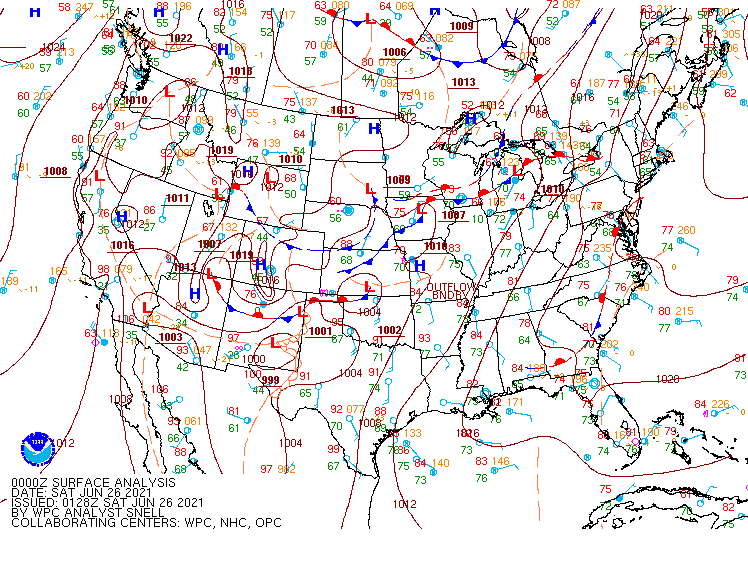
The environmental setup from June 25, 2021 to June 26, 2021 was favorable for both an excessive rainfall threat (Fig. 1) and marginal to slight severe weather threat (Fig. 2) across Southeast Michigan, as the development of a strong upper-level blocking pattern across the western United States (depicted in Fig. 3) set the stage for several rounds of showers and thunderstorms across southern lower Michigan. The event began during the morning hours of June 25, 2021 in which the first round of heavy showers and thunderstorms approached from the southwest, entering the County Warning Area (CWA) at approximately 9 am EDT. This first round of heavy rain was supported by a surface low pressure system tracking along a stationary boundary that was draped across the Great Lakes region (Fig. 4). The low encountered plenty of moisture as a subtropical airmass surged northward into SE Michigan throughout the day on June 25. The DTX 12z sounding indicated PWAT of 1.86 inches (Fig. 5), with even higher magnitude PWAT (1.94 inches) observed upstream with the 12z DVN sounding (not shown). Moisture advection was observed through much of the day as dewpoints increased from the mid-60s during the early morning (06z) to the low-70s by late afternoon (21z) (Fig. 1). Widespread rainfall accumulations of 1-3 inches were observed across the CWA by 8 pm EDT that evening, with rainfall rates in some of these storms reaching 1.5-2 inches per hour.
Following a brief lull in activity during the early evening, a second round of showers and thunderstorms developed just before 10 pm as another mid-level wave progressed over SE MI in the realm of a weakly unstable environment (Fig. 6) and surface frontal boundary (Fig. 1). The heaviest rainfall occurred along the frontal boundary, which ran approximately parallel to the I-94 corridor in Washtenaw and Wayne Counties. Shower/thunderstorm activity repeatedly trained over these areas for several hours overnight, in which precipitation rates were again on the order of 1-2 inches per hour. This additional heavy rainfall created major flooding issues, particularly in the greater metro Detroit vicinity where numerous freeway closures (including portions of major freeways such as I-94), flooded underpasses, stranded vehicles, and flooded basements were reported throughout the morning on June 26, mainly in Wayne and Washtenaw Counties. By that time, most regions across metro Detroit were reporting 24-hour rainfall amounts of 3-6 inches, although some locally higher amounts (e.g. up to 8 inches in Grosse Pointe) were reported (Fig. 7).
ii. Severe Weather
Severe weather was also a concern June 25-26, as substantial moisture and strong low-level wind shear supported a damaging wind and isolated tornado threat on both days. Although the Storm Prediction Center (SPC) initially placed SE Michigan in a Marginal Risk (with 2% tornado and 5% wind probabilities) in their 13z update on June 25, the 1630z update upgraded SE Michigan to a Slight Risk (with upgrades to 5% tornado and 15% wind probabilities). The severe weather threat on June 25, however, was highly conditional on breaks in cloud cover which ultimately did not transpire. As such, the main threat with thunderstorm development on June 25 was torrential rainfall and flash flooding. The evening of June 26, however, was a different story. The moist air mass remained in place, with PWAT of 1.88" observed in the morning DTX sounding and dewpoints persisting in the low-70s (Fig. 8). Thunderstorm development was again contingent upon breaks in cloud cover to realize instability across the region, as 1000-1500 J/kg of MLCAPE was advected into SE Michigan (Fig. 9). CAPE distribution was thin and well-distributed throughout the column, indicating the potential for strong wind gusts as a result of precipitation loading (Fig. 10). With low-level lapse rates generally remaining below 5 C/km, large hail chances were minimal. The tornado threat was supported by strong low-level shear on the order of 30-40 kts in addition to low LCL heights less than 600m and curved hodograph shapes consistent with tornado development.
A line of severe thunderstorms developed early afternoon June 26 and tracked toward Southeast Michigan during the early evening. A Tornado Watch was issued for the northern half of the CWA (along and north of Livingston-Oakland-Macomb) around 4 pm EDT as satellite imagery and surface observations revealed breaks in cloud cover, sufficient for destabilization of the atmosphere (Fig. 10). Several points within the line of thunderstorms exhibited low-level velocity signatures consistent with rotating thunderstorms and possible tornadoes as they advanced toward southeast MI. As the storms tracked through the CWA, multiple severe thunderstorm and tornado warnings were issued with damage reports in both Chesaning and Port Austin. Post-event analysis and damage reports from Port Austin prompted a storm survey of the damage, which was consistent with EF-2 damage at the storm's greatest intensity.
Click on the images below to enlarge them.
 |
 |
 |
| Figure 1: Weather Prediction Center (WPC) Excessive Rainfall Outlook, valid through1200 UTC June 26, 2021. | Figure 2: Day 1 SPC Severe Weather Outlook, valid 1300 UTC June 26 to 1300 UTC June 27. | Figure 3. 300 hPa upper air analysis 0000 UTC June 27 |
 |
 |
 |
| Figure 4: WPC Surface Analysis, valid at 1800 UTC June 26, 2021 | Figure 5: Observed thermodynamic profile for DTX, valid 1200 UTC June 25, 2021. | Figure 6: Observed thermodynamic profile for DTX, valid 0000 UTC June 26, 2021. |
 |
 |
 |
| Figure 7: 72-hour quantitative precipitation estimate derived from MRMS data, valid through 1500 UTC June 28, 2021. | Figure 8: SPC surface observations valid 2100 UTC June 26, 2021. | Figure 9: SPC MLCAPE valid 2100 UTC June 26, 2021. |
 |
 |
|
Figure 10: Observed thermodynamic profile for DTX, valid 1800 UTC June 26, 2021. *Special 18z balloon launch |
Figure 11: Satellite imagery valid 1930 UTC June 26, 2021. Colorful circles represent lightning group flash count density. Image Source: CSU CIRA |
 |
Media use of NWS Web News Stories is encouraged! Please acknowledge the NWS as the source of any news information accessed from this site. |
|