Overview
A stalled low pressure system and frontal boundary across the southern Great Lakes region brought record rainfall to southeast Michigan beginning the morning of May 17, 2020 and continuing into the afternoon hours of May 19, 2020. As a result, several rivers across the region flooded including significant flooding occurring along the Saginaw River and historic flooding along the Tittabawassee River in Midland county. The heavy rain in the Tri-Cities region resulted in the catastrophic failures of the Edenville and Sanford dams northwest of the city of Midland, resulting in the issuance of rare Flash Flood Emergencies for record-breaking flooding along the Tittabawassee River that resulted in several structures and roads flooded, and the evacuation of at 10,000 residents of the city of Midland. The heavy rain also resulted in several road closures across the rest of the region as well.
In addition to the heavy rainfall, a tight pressure gradient resulting from the area of low pressure further exacerbated already high Great Lakes water levels and enabled strong east to northeast winds to produce significant lakeshore flooding along the shorelines of Lake Huron (particularly Saginaw Bay), Lake St. Clair, and western Lake Erie. Significant river flooding once again occurred along the St. Clair River as well in portions of Macomb and St. Clair counties.
While a stalled low pressure system bringing soaking rainfall often occurs at least once or twice during the spring months in the vicinity of southeast Michigan, the combination of heavy rainfall, significant lakeshore and river flooding, and the resultant dam failures in Midland county make this event historically significant.
Photos
 |
 |
 |
|
Midland Credit: Kaytie Boomer, MLive |
Midland Credit: Kaytie Boomer, MLive |
Downtown Midland Credit: WNEM |
|
Downtown Midland Credit: NBC 25 News |
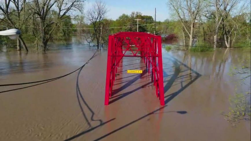
Midland Tridge Credit: WNEM |
Flooding near the city of Midland Credit: Detroit News |
|
Flooding near downtown Midland Credit: WNEM |
Flooding blocking one of numerous roads in Midland Credit: WNEM |
Midland flooding Credit: Kaytie Boomer, MLive |
|
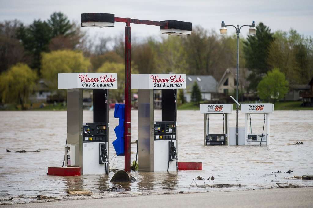
Flooding near Wixom Lake Credit: Kaytie Boomer, MLive |
Road flooding Brady Township (Saginaw county) Credit: Jared Fuller |
Several homes inundated under floodwaters in Midland Credit: Detroit News |
|
|
Radar
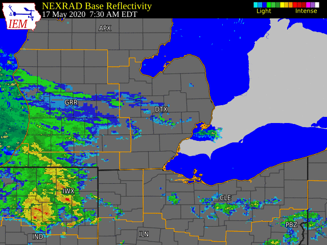  |
|
Click to Enlarg Radar loop courtesy of Iowa Environmental Mesonet (IEM) |
Storm Reports
Heavy Rainfall Local Storm Reports:
...PRELIMINARY 48 HOUR RAINFALL TOTALS...

LOCATION                     AMOUNT    TIME/DATE       LAT/LON

...MICHIGAN...

...BAY COUNTY...
BAY CITY 2.4 W               3.53 IN   0700 AM 05/19   43.59N/83.94W
AUBURN                       3.50 IN   0915 AM 05/19   43.60N/84.10W
BAY CITY 2.8 ESE             3.19 IN   0700 AM 05/19   43.58N/83.84W
BAY CITY                     1.89 IN   0915 AM 05/19   43.69N/83.92W

...GENESEE COUNTY...
FLINT BISHOP ASOS            3.06 IN   0913 AM 05/19   42.97N/83.75W
FLUSHING 5 SSE               2.43 IN   0800 AM 05/19   42.99N/83.82W
SWARTZ CREEK 1.1 N           2.28 IN   0700 AM 05/19   42.98N/83.83W
CLIO 2.4 WNW                 1.75 IN   0700 AM 05/19   43.20N/83.78W
GRAND BLANC 2.9 SE           1.65 IN   0700 AM 05/19   42.89N/83.59W
LINDEN                       1.60 IN   0923 AM 05/19   42.81N/83.80W
SWARTZ CREEK                 1.58 IN   0921 AM 05/19   42.96N/83.86W
GENESEE 3.4 SE               1.45 IN   0700 AM 05/19   43.07N/83.59W
GOODRICH                     1.32 IN   0730 AM 05/19   42.92N/83.51W

...HURON COUNTY...
PORT AUSTIN 1.3 E            4.02 IN   0745 AM 05/19   44.05N/82.97W
PORT HOPE ASOS               4.00 IN   0851 AM 05/19   44.02N/82.80W
BAY PORT 3.2 SSW             2.96 IN   0800 AM 05/19   43.81N/83.40W
CASEVILLE                    2.38 IN   0929 AM 05/19   43.91N/83.38W
BAD AXE                      1.91 IN   0744 AM 05/19   43.82N/83.00W
PORT AUSTIN                  1.90 IN   0930 AM 05/19   44.05N/83.00W
BAD AXE 0.5 SSW              1.87 IN   0800 AM 05/19   43.80N/83.00W
BAD AXE                      1.71 IN   0916 AM 05/19   43.80N/83.02W

...LAPEER COUNTY...
LAPEER                       1.25 IN   0915 AM 05/19   43.07N/83.27W

...LENAWEE COUNTY...
MORENCI                      3.26 IN   0730 AM 05/19   41.72N/84.20W
TECUMSEH 0.5 SW              2.77 IN   0625 AM 05/19   42.00N/83.95W
CLINTON 0.5 NE               2.69 IN   0900 AM 05/19   42.08N/83.97W
TIPTON 2.2 NW                2.49 IN   0800 AM 05/19   42.03N/84.10W
ADRIAN ASOS                  2.37 IN   0853 AM 05/19   41.87N/84.08W
ADRIAN                       2.12 IN   0917 AM 05/19   41.91N/84.08W
ADRIAN                       1.89 IN   0925 AM 05/19   41.91N/84.02W
BLISSFIELD 1.2 WNW           1.88 IN   0800 AM 05/19   41.84N/83.88W

...LIVINGSTON COUNTY...
PINCKNEY                     2.38 IN   0930 AM 05/19   42.48N/83.87W
MILFORD                      1.96 IN   1200 AM 05/19   42.58N/83.70W
FENTON 6.2 WSW               1.89 IN   0800 AM 05/19   42.77N/83.83W
HOWELL                       1.79 IN   0916 AM 05/19   42.62N/83.97W
GREGORY                      1.66 IN   0927 AM 05/19   42.44N/84.07W
PINCKNEY                     1.65 IN   0930 AM 05/19   42.48N/84.00W

...MACOMB COUNTY...
WASHINGTON                   2.29 IN   1200 PM 05/19   42.72N/83.04W
SHELBY 2.6 SW                1.92 IN   0844 AM 05/19   42.64N/83.07W
SHELBY 0.4 SSE               1.81 IN   0600 AM 05/19   42.67N/83.03W
WARREN                       1.42 IN   0926 AM 05/19   42.51N/83.00W
FRASER 1.2 N                 1.21 IN   0830 AM 05/19   42.56N/82.95W
STERLING HEIGHTS             1.00 IN   0928 AM 05/19   42.79N/83.02W
ROSEVILLE 1.7 ENE            0.97 IN   0500 AM 05/19   42.51N/82.90W
CHESTERFIELD 2.4 E           0.95 IN   0543 AM 05/19   42.67N/82.79W
DETROIT                      0.94 IN   0925 AM 05/19   42.52N/82.88W
NEW BALTIMORE 0.4 SSE        0.88 IN   0800 AM 05/19   42.68N/82.74W


...MIDLAND COUNTY...
MIDLAND 1.5 NNE              4.70 IN   0600 AM 05/19   43.64N/84.22W
BAY CITY                     4.22 IN   0930 AM 05/19   43.62N/84.24W
MIDLAND 4.4 W                4.18 IN   0817 AM 05/19   43.63N/84.32W
MIDLAND 2.9 SW               4.10 IN   0817 AM 05/19   43.59N/84.27W
FREELAND 7.6 W               4.03 IN   0800 AM 05/19   43.52N/84.27W
OIL CITY 3.0 E               3.69 IN   0730 AM 05/19   43.61N/84.53W
MIDLAND BARSTOW              1.85 IN   0916 AM 05/19   43.67N/84.27W

...MONROE COUNTY...
MONROE 2 S                   1.62 IN   0930 AM 05/19   41.87N/83.39W
MONROE                       1.44 IN   0915 AM 05/19   41.93N/83.42W
STONY POINT 2 W              1.07 IN   0930 AM 05/19   41.95N/83.32W
DUNDEE                       0.98 IN   0915 AM 05/19   41.96N/83.62W

...OAKLAND COUNTY...
BLOOMFIELD TOWNSHIP 3.1 SW   2.27 IN   0700 AM 05/19   42.55N/83.32W
FRANKLIN                     2.19 IN   0915 AM 05/19   42.52N/83.32W
NOVI                         2.17 IN   0922 AM 05/19   42.45N/83.45W
HOLLY                        2.15 IN   0901 AM 05/19   42.82N/83.68W
HIGHLAND 1.3 NE              2.12 IN   0730 AM 05/19   42.68N/83.59W
FARMINGTON HILLS             2.06 IN   0800 AM 05/19   42.49N/83.38W
SOUTHFIELD 2.8 NNE           2.05 IN   0800 AM 05/19   42.51N/83.24W
SOUTHFIELD 2 NNW             1.98 IN   0929 AM 05/19   42.52N/83.27W
BLOOMFIELD HILLS             1.90 IN   0925 AM 05/19   42.62N/83.22W
DAVISBURG 1.3 ESE            1.82 IN   0800 AM 05/19   42.74N/83.52W
FARMINGTON 0.6 E             1.81 IN   0730 AM 05/19   42.47N/83.37W
WHITE LAKE 3.4 NE            1.76 IN   0800 AM 05/19   42.70N/83.47W
SOUTH LYON 3.7 N             1.69 IN   0700 AM 05/19   42.51N/83.65W
BERKLEY 0.5 WSW              1.67 IN   0700 AM 05/19   42.49N/83.19W
LAKE ORION                   1.61 IN   0800 AM 05/19   42.78N/83.24W
WEST BLOOMFIELD              1.58 IN   0927 AM 05/19   42.58N/83.41W
WIXOM 1.3 NE                 1.56 IN   0645 AM 05/19   42.54N/83.52W
CLARKSTON 1.4 NE             1.50 IN   0700 AM 05/19   42.75N/83.40W
ROYAL OAK                    1.45 IN   0920 AM 05/19   42.53N/83.13W
ORTONVILLE 2.3 S             1.42 IN   0715 AM 05/19   42.82N/83.44W
PONTIAC AIRPORT ASOS         1.41 IN   0853 AM 05/19   42.67N/83.42W
FENTON 2.1 NE                1.31 IN   0801 AM 05/19   42.82N/83.68W
ORTONVILLE                   1.30 IN   0929 AM 05/19   42.83N/83.42W
PLEASANT RIDGE 0.5 WNW       1.29 IN   0815 AM 05/19   42.47N/83.15W
WATERFORD                    1.28 IN   0921 AM 05/19   42.67N/83.36W
COMMERCE TOWNSHIP            1.24 IN   0930 AM 05/19   42.59N/83.51W
ORTONVILLE                   1.17 IN   0916 AM 05/19   42.85N/83.41W
ROCHESTER HILLS              1.15 IN   0925 AM 05/19   42.66N/83.13W
BEVERLY HILLS                1.13 IN   0916 AM 05/19   42.52N/83.26W
WEST BLOOMFIELD              1.08 IN   0929 AM 05/19   42.56N/83.39W


...SAGINAW COUNTY...
CHESANING 4 WSW              4.30 IN   0900 AM 05/19   43.30N/84.21W
ST CHARLES 7W                4.20 IN   0600 AM 05/19   43.30N/84.29W
SAGINAW - TRI-CITIES ASOS    3.99 IN   0853 AM 05/19   43.53N/84.08W

...SANILAC COUNTY...
LEXINGTON                    1.39 IN   0730 AM 05/19   43.26N/82.53W
DECKERVILLE                  1.17 IN   0915 AM 05/19   43.50N/82.70W
MINDEN CITY                  0.79 IN   0929 AM 05/19   43.69N/82.77W
MELVIN                       0.67 IN   0930 AM 05/19   43.18N/82.86W
BROWN CITY                   0.62 IN   0922 AM 05/19   43.21N/82.98W

...SHIAWASSEE COUNTY...
OWOSSO                       3.87 IN   0916 AM 05/19   42.99N/84.18W
OWOSSO  2.3 SW               3.28 IN   0700 AM 05/19   42.97N/84.20W
DURAND 6.2 WNW               3.19 IN   0800 AM 05/19   42.93N/84.10W
ELSIE                        2.48 IN   0916 AM 05/19   43.10N/84.34W
DURAND 1.0 N                 2.48 IN   0800 AM 05/19   42.93N/83.99W


...ST. CLAIR COUNTY...
ST CLAIR RIVER               1.85 IN   0600 AM 05/19   42.62N/82.53W
YALE 1 NNE                   1.08 IN   0640 AM 05/19   43.15N/82.80W
PORT HURON                   0.47 IN   0915 AM 05/19   43.01N/82.42W

...TUSCOLA COUNTY...
REESE                        1.83 IN   0916 AM 05/19   43.46N/83.68W
CASS CITY 1.4 SW             1.73 IN   0630 AM 05/19   43.58N/83.18W
CARO                         1.71 IN   0725 AM 05/19   43.45N/83.40W
VASSAR                       1.44 IN   0700 AM 05/19   43.37N/83.58W

...WASHTENAW COUNTY...
SALINE 2.7 SSW               3.19 IN   0800 AM 05/19   42.14N/83.80W
DEXTER 2.2 SE                3.01 IN   0700 AM 05/19   42.30N/83.86W
DEXTER 0.3 ENE               2.84 IN   0730 AM 05/19   42.33N/83.88W
ANN ARBOR 2.1 WNW            2.76 IN   0800 AM 05/19   42.28N/83.77W
SALINE 1.3 SSE               2.75 IN   0700 AM 05/19   42.16N/83.77W
SALINE                       2.68 IN   1100 AM 05/19   42.18N/83.78W
ANN ARBOR 7.1 W              2.65 IN   0700 AM 05/19   42.26N/83.87W
CHELSEA 3.7 NNE              2.33 IN   0800 AM 05/19   42.36N/83.99W
ANN ARBOR 3.1 SE             2.23 IN   0700 AM 05/19   42.24N/83.70W
ANN ARBOR ASOS               2.15 IN   0927 AM 05/19   42.30N/83.71W
CHELSEA 2.4 S                2.06 IN   0800 AM 05/19   42.28N/84.03W
WHITMORE LAKE                2.04 IN   0915 AM 05/19   42.41N/83.73W
YPSILANTI                    1.78 IN   0923 AM 05/19   42.26N/83.59W
MANCHESTER                   1.72 IN   0928 AM 05/19   42.13N/84.08W
YPSILANTI 2.5 SSE            1.71 IN   0725 AM 05/19   42.21N/83.60W
PLYMOUTH 5.4 W               1.57 IN   0700 AM 05/19   42.38N/83.57W
MANCHESTER                   1.49 IN   0929 AM 05/19   42.14N/84.07W
PLYMOUTH 6.3 W               1.46 IN   0800 AM 05/19   42.38N/83.59W
SALEM TWP                    1.40 IN   0919 AM 05/19   42.39N/83.60W

...WAYNE COUNTY...
DEARBORN HEIGHTS 1.8 NW      2.00 IN   0500 AM 05/19   42.34N/83.30W
LIVONIA 2.0 NE               1.99 IN   0700 AM 05/19   42.42N/83.34W
BELLEVILLE 2.8 ESE           1.91 IN   0700 AM 05/19   42.18N/83.44W
DEARBORN 3.2 NE              1.88 IN   0911 AM 05/19   42.35N/83.17W
DEARBORN 3.5 NE              1.88 IN   0912 AM 05/19   42.35N/83.17W
CANTON 2.7 N                 1.74 IN   0700 AM 05/19   42.35N/83.47W
WOODHAVEN 0.9 WNW            1.72 IN   0700 AM 05/19   42.14N/83.25W
DETROIT WILLOW               1.67 IN   0911 AM 05/19   42.23N/83.53W
TAYLOR                       1.62 IN   0921 AM 05/19   42.23N/83.23W
DETROIT METRO AIRPORT ASOS   1.92 IN   0853 AM 05/19   42.23N/83.33W
FLAT ROCK 0.7 NNW            1.58 IN   0600 AM 05/19   42.11N/83.28W
SOUTHGATE                    1.51 IN   0600 AM 05/19   42.20N/83.21W
RIVERVIEW 2.4 NE             1.45 IN   0800 AM 05/19   42.20N/83.17W
LIVONIA 2.3 NNW              1.39 IN   0730 AM 05/19   42.43N/83.38W
DEARBORN 1 SW                1.26 IN   0929 AM 05/19   42.29N/83.24W
SOUTHWEST DETROIT 2 SSE      1.18 IN   0929 AM 05/19   42.30N/83.10W
CANTON                       1.08 IN   0915 AM 05/19   42.31N/83.46W
GROSSE ILE 1.6 N             1.03 IN   0700 AM 05/19   42.15N/83.15W
DETROIT CITY AIRPORT ASOS    0.90 IN   0853 AM 05/19   42.40N/83.02W


OBSERVATIONS ARE COLLECTED FROM A VARIETY OF SOURCES (COCORAHS, ASOS, CWOP, COOP,
AND TRAINED SPOTTERS) WITH VARYING EQUIPMENT AND EXPOSURES. WE THANK ALL VOLUNTEER
WEATHER OBSERVERS FOR THEIR DEDICATION. NOT ALL DATA LISTED ARE CONSIDERED OFFICIAL.

$$
Environment
NOTE: This section will focus on the meteorology behind this event. For a hydrology discussion, refer to the River and Areal Flooding tab. For a lakeshore flooding discussion, refer to the Lakeshore Flooding tab. The Catastrophic Dam Failure Flooding Midland County tab will offer a unique discussion on the hydrometeorological factors that contributed to the historic flooding experienced in Midland county.
The stalled low pressure system that brought 2-4+ inches of rain to the region beginning the morning of May 17, 2020 and continuing into the afternoon hours of May 19, 2020 exhibited a few unique meteorological qualities that made it a historical rather than normative event. Typically, southeast Michigan experiences a stalled, or closed, low pressure system at least once or twice every spring season as westerly flow between the polar and subtropical jets becomes pinched off. These systems can last on the order of a few days, and usually bring periodic soaking rains and/or thunderstorms to the region before slowly wobbling off to the east or southeast. In the case of this event, the atmospheric pattern in the upper-levels exhibited a quasi-Rex Block pattern over the eastern third of the United States, with ridging aloft across northern Ontario and James Bay and troughing over the northern Gulf of America (Fig. 1). This pattern was further enhanced by the slow northeast progression of the early-season Tropical Storm Arthur just off the eastern seaboard. Across the lower Great Lakes, a closed surface low was vertically-stacked in vicinity of southern Lake Michigan all the way from the surface to 300 hPa (Fig. 2). Couple the stacked nature of the low pressure system and the overall synoptic blocking pattern in place, the conditions were set for a prolonged period of stalled low pressure near the region.
Figure 3 depicts the Weather Prediction Center (WPC) surface analysis valid at 8 AM on May 18. A stalled surface low can be seen just southwest of Chicago, with a warm front boundary extending eastward along the Michigan/Indiana/Ohio line. This surface pattern largely remained in place through the event, with a narrow corridor of stronger (25-35 knot) winds in the low-levels transporting moisture all the way northward from the Gulf of America (Figs. 4 and 5). With Gulf-rich moisture being transported northward, precipitable water (PW) values were able to increase into the 1.30-1.50 inch range, near record values for mid-May (Fig. 6). A near-continuous source of lift was provided during this time as well as multiple spokes of midlevel energy rotated around the closed upper-level low aloft, aided by enhanced wind maxima rotating around the closed flow. In fact, the source of lift was so consistent that it helped enhance low-level frontogenetical forcing (red lines and shading) and even produced pockets of conditional symmetric instability represented by values of equivalent potential vorticity (EPV) less than 0. These pockets of negative EPV could have been a part in focusing heavier mesoscale rain segments such as the ones that affected the Tri-Cities region.
Although thunderstorms were not as widespread as what occurred to the south of the region in Ohio and parts of Indiana, there was just enough instability present to sustain robust updrafts capable of producing heavy rain with MUCAPE values as high as 500 J/kg at times (Fig. 7) during peak daytime heating. Further maximizing the heavy rain potential, in addition to the long duration of the event as a whole, was the precipitation efficiency. Figure 8 depicts the 8PM KDTX sounding valid May 19. This sounding was taken just after the peak in the diurnal heating cycle, with some remnant of a tall, skinny CAPE profile still present, albeit marginal at best. However, the freezing level and wet bulb temperature are of particular note for this sounding – 11.4 kft and 11.2 kft respectively. These values are on the high end for average mid-May values, and are indicative of a deep warm cloud layer that allows for a longer residence time of collision coalescence processes. The longer these processes can occur, especially given the repeated nature of rain activity through this event, the more efficient the overall rain accumulation process can become.
A tight pressure gradient from the aforementioned placement of the closed low and high to the north also resulted in a long duration of abnormally gusty east to northeast flow for mid-May. Gusts of 30-35 mph at times were common, which only exacerbated lakeshore flooding concerns (see Lakeshore Flooding tab for more details). The stalled low finally began to drift to the southeast by May 19, 2020 as Post Tropical Cyclone Arthur lifted further northeast. With the low further southeast, rainfall finally came to an end.
The heavy rainfall brought poor drainage flooding across much of the region, but the area that was hardest hit was the Tri-Cities region. Here, where the greatest rainfall totals occurred, the combination of fairly wet antecedent conditions and stressed conditions at the Edenville and Sanford dams resulted in catastrophic failures and extremely dangerous flash flooding downstream along the Tittabawassee River in Midland county. The communities of Sanford and Midland were particularly hard it, with several areas in these communities being under several feet of water. The amount of water that impacted these areas had not been seen since 1986. In these cities, numerous roadways were closed, structures inundated, and evacuations of thousands of people initiated. More information about these efforts can be found in the Catastrophic Dam Failure Flooding Midland County tab. Fortunately for the Detroit metro, the heaviest rain occurred just to the south and west and sparing the city from potentially significant urban flooding concerns.
Click on the images below to see them expanded.
 |
 |
 |
| Figure 1: Storm Prediction Center (SPC) 500 hPa map, valid 12 UTC (8 AM EDT) 18 May 2020. | Figure 2: SPC 300 hPa map, valid 12 UTC (8 AM EDT) 18 May 2020. | Figure 3: Weather Prediction Center surface map, valid 12 UTC (8 AM EDT) 18 May 2020. |
 |
 |
|
| Figure 4: SPC 850 hPa map, valid 12 UTC (8 AM EDT) 18 May 2020. | Figure 5: SPC 850 hPa moisture propagation, valid 00 UTC (8 PM EDT) 19 May 2020 | |
 |
 |
 |
| Figure 6: SPC PW map, valid 18 UTC (2 PM EDT) 18 May 2020. | Figure 7: SPC MUCAPE map, valid 18 UTC (2 PM EDT) 18 May 2020. | Figure 8: KDTX observed sounding, valid 00 UTC (8 PM EDT) 19 May 2020. |
Lakeshore Flooding
NOTE: All data in the images below, including record water levels, are preliminary.
A tight pressure gradient resulting from the closed low pressure system anchored over southern Lake Michigan and high pressure over Quebec and the Northeast United States resulted in a prolonged period of strong east to northeasterly onshore winds. These winds were particularly strong over the open lake waters, with channeling effects resulting in a rare late season gale event for Saginaw Bay. Small Craft Advisories were in effect for the remaining nearshore areas along Lake Huron, Lake St. Clair, and western Lake Erie. The combination of high water levels, persistently strong onshore winds, and elevated waves resulted in significant lakeshore flooding for many shoreline areas of southeast Michigan. Some of the hardest hit regions included shoreline areas in Bay and Tuscola counties, Monroe and southeastern Wayne county, and the Lake St. Clair shoreline. In fact, record water levels were observed at the St. Clair Shores and Gibraltar gauges which resulted in the closure of several roads and some inundation of nearby shoreline structures.
Click on the images below to see them expanded.
 |
 |
 |
| Figure 1: Essexville gauge. Peak readings were around 71 inches above low water datum (LWD). | Figure 2: Algonac gauge. Peak readings were around 64 inches above LWD. | Figure 3: Fermi gauge. Peak readings were around 82 inches above LWD. |
 |
 |
 |
| Figure 4: Gibraltar gauge. Record peak readings were around 79 inches above LWD. | Figure 5: St. Clair Shores gauge. Record peak readings were around 68 inches above LWD. | Figure 6: Toledo gauge. Peak readings were around 88 inches above LWD. |
River and Areal Flooding
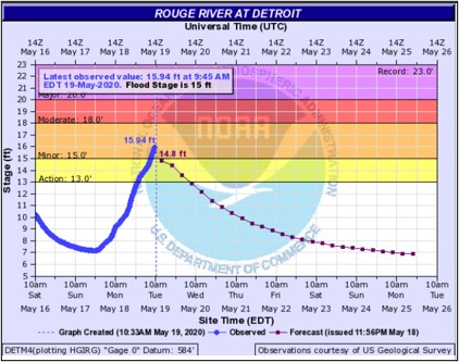
The widespread heavy rainfall resulted in several road closures across the region due to significant ponding of water on roadways. Many streams and rivers across the region quickly rose to near bankful, with minor river flooding occurring along the Shiawassee River near Owosso, Swartz Creek near Flint, and Rouge River in portions of Detroit.
However, the most significant river flooding occurred where the heaviest rain fell – across the Tri-Cities region. In this region, some locations reported well over 4 inches of rain which simply overwhelmed the local watersheds and allowed river levels to rapidly rise well into flood. Moderate flooding was observed along the Saginaw River near Saginaw, with historic record flooding occurring along the Tittabawassee River in Midland county. The record flood levels along the Tittabawassee River were exacerbated due to extra water from catastrophic dam failures at the Edenville and Sanford dams. This flooding, the worst since 1986, resulted in major flooding in the community of Sanford and city of Midland. Multiple structures and roads were inundated under several feet of water. Thousands of people had to evacuate due to the flood waters. The flooding resulted in much of downtown Midland being submerged under several feet of water. Notable river flooding also occurred along the St. Clair River due to the combination of strong easterly winds, high water levels, and runoff from the recent heavy rain.
Click on the images below to see them expanded.
 |
 |
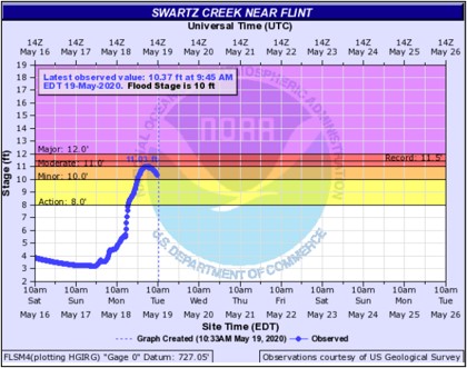 |
| Figure 1: Hydrograph of the Tittabawassee River at Midland. | Figure 2: Hydrograph of the Saginaw River at Saginaw. | Figure 3: Hydrograph of Swartz Creek at Flint. |
 |
 |
 |
| Figure 4: Hydrograph of the Hamburg River at Hamburg. | Figure 5: Hydrograph of the River Rouge at Detroit. | Figure 6: Hydrograph of the Shiawassee River at Owosso. |
Historic Dam Failure Flooding Midland County
Significant amounts of rainfall fell within a roughly 36 hour period beginning May 17, 2020 and ending May 19, 2020. During this time, the heaviest rainfall occurred across the Tri Cities region and further north into northern Lower Michigan. Widespread rainfall totals of 5-8 inches were observed in this region (Fig. 1), which simply overwhelmed the Tittabawassee River watershed. Exacerbating this issue was an already stressed dam system at Edenville and Sanford, which helps control the downstream flow along the Tittabawassee River into the city of Midland and eventually the Saginaw River.
With increasing elevation heading north into northern lower Michigan, the heaviest rain totals (7-8 inches in Gladwin and Arenac counties), resulted in excess runoff flowing in a general north to south direction towards the Edenville and Sanford dams. By the evening of May 19, 2020, catastrophic dam failures had occurred at both the Edenville and Sanford dams. The result was historic flash flooding that occurred downstream first in the towns of Edenville and Sanford, and later impacting much of the city of Midland. Much of downtown Midland was inundated as a result, along with the complete destruction of several homes and other structures. Numerous roads were closed due to washouts and bridges being destroyed. As much as 10,000 people were evacuated. Rare Flash Flood Emergencies were issued for the flooding, which highlighted the risk for catastrophic, life-threatening flooding. The magnitude of the flooding was the worst the region had seen since 1986 and 2017.
To help further understand the historic nature of this event, the rainfall recurrence interval for the Tittabawassee River watershed is estimated to be a once in a 200 year event. To explain this in a different way, each year this amount of rainfall has a 0.05% chance of occurring across this basin. These values are estimated, however, as recurrence intervals are calculated for point locations, not an entire watershed. However, the cumulative effects of the dam failures on top of the heavy rain resulted in a much greater historical effect to the magnitude of flooding experienced in the city of Midland and nearby surrounding areas. At the very least, the flooding that occurred will be remembered as a generation-defining event for those who experienced it firsthand.
|
Figure 1. Observed rainfall map from the North Central River Forecast Center (left); map of the Saginaw River watershed with approximate area of heaviest rainfall outlined in red. |
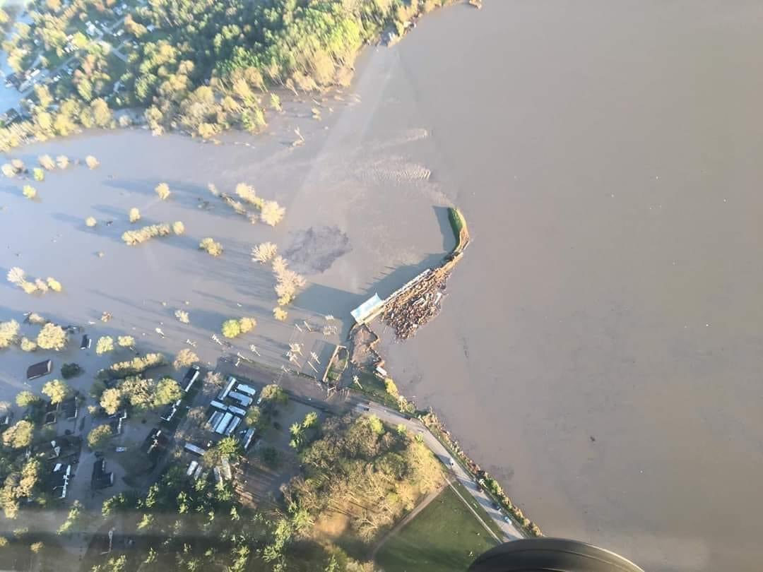
Figure 2. Wixom Lake after the Edenville dam failure. Notice all that remains is the remnant Tittabawassee River channel. Credit: WDIV. |
|
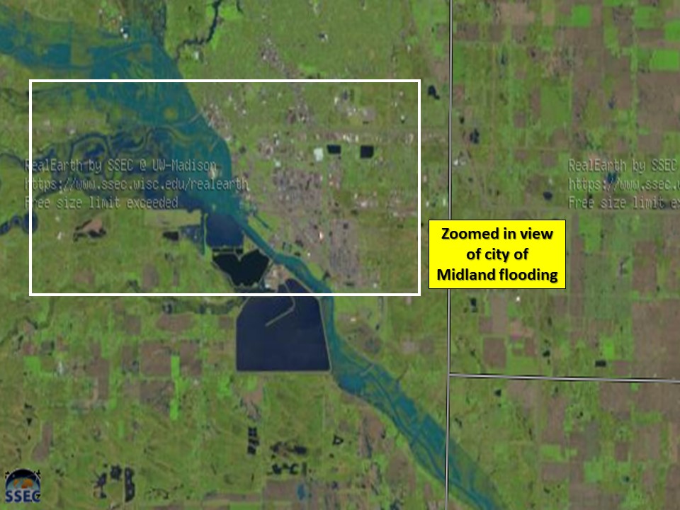
Figure 3. Landsat image of the flooded Tittabawassee River. Notice how blue the river appears in the satellite imagery as a result of the recent flooding. |
Figure 4. Zoomed-in landsat image of the flooded Tittabawassee River near the city of Midland. Notice how blue the river appears in the satellite imagery as a result of the flooding. |
|
Figure 5. Image of the failed Sanford dam. Credit: Ahmad Bajjey. |
Figure 6. Midland county road closures during the peak of the Titabawassee River flooding. Credit: MDOT. |
|
Figure 7. Aerial footage of the failure of the Edenville dam. Credit: Midland Daily News. |
Figure 8. Various flooding damage photos as a result of the Edenville and Sanford dam failures. For additional pictures, see the Photos tab. Credit: WDIV. |
 |
Media use of NWS Web News Stories is encouraged! Please acknowledge the NWS as the source of any news information accessed from this site. |
|