Overview
Just in time for the autumnal equinox, a pattern-changing series of low pressure systems and attendant strong cold front brought heavy rainfall, strong winds, and cooler temperatures to the Great Lakes region from September 21st-23rd, 2021. Heavy rainfall was aided by a deep supply of moisture, while strong winds developed in the wake of a tight surface pressure gradient around the low pressure center. Overall, a total of 2-5 inches of rain were observed, with the highest totals in Oakland and Wayne Counties (over 5 inches in some locations). This led to localized areas of minor flooding as well as minor to moderate flooding on the Saginaw, Clinton, Huron, and Rouge Rivers. Strong winds, with localized gusts to 50 mph, were observed across Lake Huron and nearshore counties; although gusty winds impacted the entire County Warning Area (CWA), leading to scattered power outages across Southeast Michigan. Flood headlines, Gale Warnings, Small Craft Advisories, and wind headlines were all issued throughout the event period to account for these hazards.
Radar
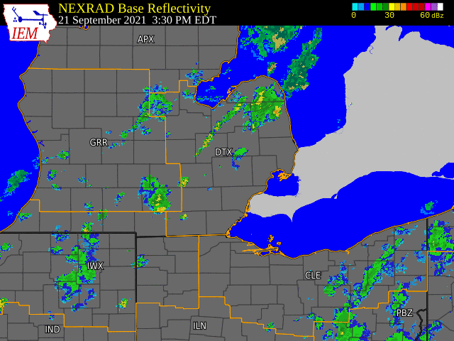
|
Radar Loop Radar Imagery for Sep 21-23, 2021 - Heavy Rain Radar loop courtesy of Iowa Environmental Mesonet (IEM) |
Storm Reports
 |
|
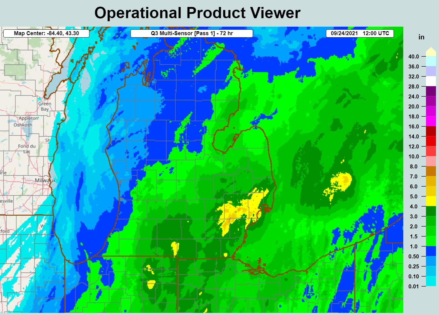
Rainfall Total Map Above image depicts 72-hour MRMS rainfall estimate for lower MI in the period from September 21-24th. Data courtesy of NSSL MRMS Operational Product Viewer |
 |
|
Peak Observed Wind Gusts (mph) - September 22nd-23rd |
Heavy Rainfall Local Storm Reports:
...PRECIPITATION REPORTS...

Location                     Amount    Time/Date

...Michigan...

...Bay County...
3 ESE Essexville             1.79 in   0900 PM 09/23
Auburn                       1.57 in   0900 AM 09/23

...Genesee County...
Linden                       3.46 in   0900 AM 09/23
2 E Goodrich                 3.40 in   0600 PM 09/23
2 SE Grand Blanc             3.28 in   1000 AM 09/23
3 E Swartz Creek             3.17 in   0800 PM 09/23
Flint                        2.68 in   0800 AM 09/23
4 N Burton                   2.48 in   0900 AM 09/23
Goodrich                     2.05 in   0900 AM 09/23
1 SSW Fenton                 1.42 in   0815 AM 09/22

...Huron County...
Harbor Beach                 2.60 in   0538 PM 09/22
Bad Axe                      1.71 in   0900 AM 09/23

...Lapeer County...
Lapeer                       2.34 in   0900 AM 09/23
2 NW Columbiaville           2.24 in   1100 PM 09/22
2 W Lapeer                   1.34 in   0830 AM 09/22

...Lenawee County...
2 NW Seneca                  3.84 in   0800 PM 09/23
3 SSW Adrian                 3.80 in   0800 PM 09/23
Adrian                       3.79 in   0800 AM 09/23
Morenci                      3.13 in   0900 AM 09/23
3 SW Adrian                  1.89 in   0800 PM 09/22

...Livingston County...
1 NNW Whitmore Lake          3.93 in   0900 AM 09/23
Howell                       3.60 in   0730 AM 09/23
2 SSE Fenton                 3.07 in   0815 AM 09/23
Brighton                     2.60 in   0800 AM 09/23

...Macomb County...
Armada                       5.00 in   0610 PM 09/22
2 S Armada                   4.40 in   0700 PM 09/22
2 SE Utica                   4.25 in   0630 PM 09/22
2 NW Saint Clair Shores      4.06 in   1000 AM 09/23
Warren                       3.72 in   0700 AM 09/22
2 E Mount Clemens            3.65 in   0800 PM 09/23
Mount Clemens                3.60 in   0900 AM 09/23
2 SSE Fraser                 3.39 in   0900 AM 09/23
3 N Utica                    3.00 in   0220 PM 09/22
2 SSW Memphis                2.98 in   0820 AM 09/22
Macomb Township              2.40 in   1221 AM 09/22
2 SSE Fraser                 1.07 in   1246 PM 09/22

...Midland County...
Midland                      1.52 in   0900 PM 09/23
Oil City                     1.00 in   0900 AM 09/23

...Monroe County...
Lambertville                 5.60 in   0554 PM 09/23
2 S Carleton                 4.08 in   1000 AM 09/23
3 E La Salle                 3.87 in   1000 AM 09/23
3 WNW Stony Point            3.23 in   0430 PM 09/22
3 NW Monroe                  1.78 in   0800 PM 09/23

...Oakland County...
2 N Farmington               6.36 in   1000 AM 09/23
Bloomfield Hills             5.55 in   0730 AM 09/23
Farmington                   5.28 in   0900 AM 09/23
Orchard Lake                 4.98 in   1000 AM 09/23
1 SSE Troy                   4.57 in   1000 AM 09/23
Pontiac                      4.45 in   0900 AM 09/23
White Lake                   4.07 in   0800 AM 09/23
4 WNW Orchard Lake           3.99 in   0600 PM 09/23
Troy                         3.96 in   1000 AM 09/22
3 NNE White Lake             3.86 in   0800 PM 09/23
5 ESE Milford                3.51 in   0900 AM 09/23
4 ESE Milford                3.50 in   1000 AM 09/23
Clarkston                    3.39 in   0730 AM 09/23
1 W Waterford                3.13 in   0800 PM 09/23
2 NNE Royal Oak              3.00 in   0415 PM 09/22
4 NW Novi                    2.57 in   1000 PM 09/22
1 NE Royal Oak               2.50 in   0853 AM 09/22
Highland                     2.32 in   0900 AM 09/22
2 WSW Waterford              2.08 in   0145 PM 09/22
3 NW White Lake              1.93 in   0930 AM 09/22
1 S Clarkston                1.72 in   0730 AM 09/22

...Saginaw County...
Burt                         3.75 in   0900 PM 09/23
Saginaw                      2.52 in   0900 AM 09/23
3 NW Oakley                  2.10 in   0943 AM 09/23
2 ENE Freeland               1.84 in   0800 PM 09/23
3 ESE Freeland               1.47 in   0900 AM 09/23

...Shiawassee County...
Owosso                       1.97 in   0900 AM 09/23

...St. Clair County...
2 ENE Wadhams                5.25 in   0500 PM 09/22
Marine City                  3.30 in   0730 AM 09/23
Marysville                   2.18 in   0750 AM 09/22
Port Huron                   1.90 in   1200 AM 09/22
Algonac                      1.52 in   0800 AM 09/22

...Washtenaw County...
Ann Arbor                    4.53 in   0900 AM 09/23
2 E Ypsilanti                4.31 in   0748 PM 09/23
2 SE Dexter                  4.03 in   1000 AM 09/23
Milan                        3.80 in   0900 AM 09/23
4 SE Bridgewater             3.77 in   0900 AM 09/23
Ann Arbor                    3.63 in   0600 PM 09/22
2 W Ypsilanti                3.50 in   0730 AM 09/22
Saline                       3.30 in   1000 AM 09/23
Manchester                   3.29 in   0900 AM 09/23
4 S Ann Arbor                2.69 in   0800 PM 09/23
Ann Arbor                    1.87 in   0700 AM 09/22
Chelsea                      1.60 in   0930 AM 09/22

...Wayne County...
Westland                     6.20 in   0900 PM 09/23
1 S Southwest Detroit        5.32 in   1000 AM 09/23
1 NE Grosse Pointe           5.10 in   0900 AM 09/23
2 NNW Riverview              4.65 in   0230 PM 09/23
2 ENE Romulus                4.47 in   0800 PM 09/23
Romulus                      4.26 in   0800 AM 09/23
2 ESE Belleville             4.26 in   1000 AM 09/23
3 SSE Lincoln Park           4.21 in   0900 AM 09/23
1 NW Dearborn                3.67 in   1000 AM 09/23
3 ENE Westland               3.35 in   0500 PM 09/22
Livonia                      3.30 in   0500 PM 09/22
1 N Grosse Ile               3.12 in   1000 AM 09/23
Dearborn                     2.48 in   0830 AM 09/22
1 S Plymouth                 2.09 in   0700 AM 09/22

Observations are collected from a variety of sources with varying
equipment and exposures. We thank all volunteer weather observers
for their dedication. Not all data listed are considered official.

$$
Environment Overview
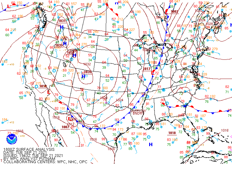
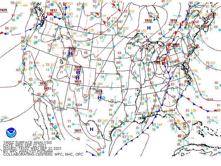
The heavy rain event began Tuesday afternoon (9/21) as a strong cold front draped across the meridional extent of CONUS tracked eastward into the upper Midwest region (Fig 1). In anticipation of the approaching heavy rainfall, a Flood Watch was issued, in effect from 4 PM EDT Tuesday afternoon through Thursday morning (9/24). Similarly, Gale Warnings and Small Craft Advisories were issued for the Lake Huron open waters and nearshore zones in anticipation of wind gusts exceeding 40 kts and potential maximum wave heights up to 22 feet.
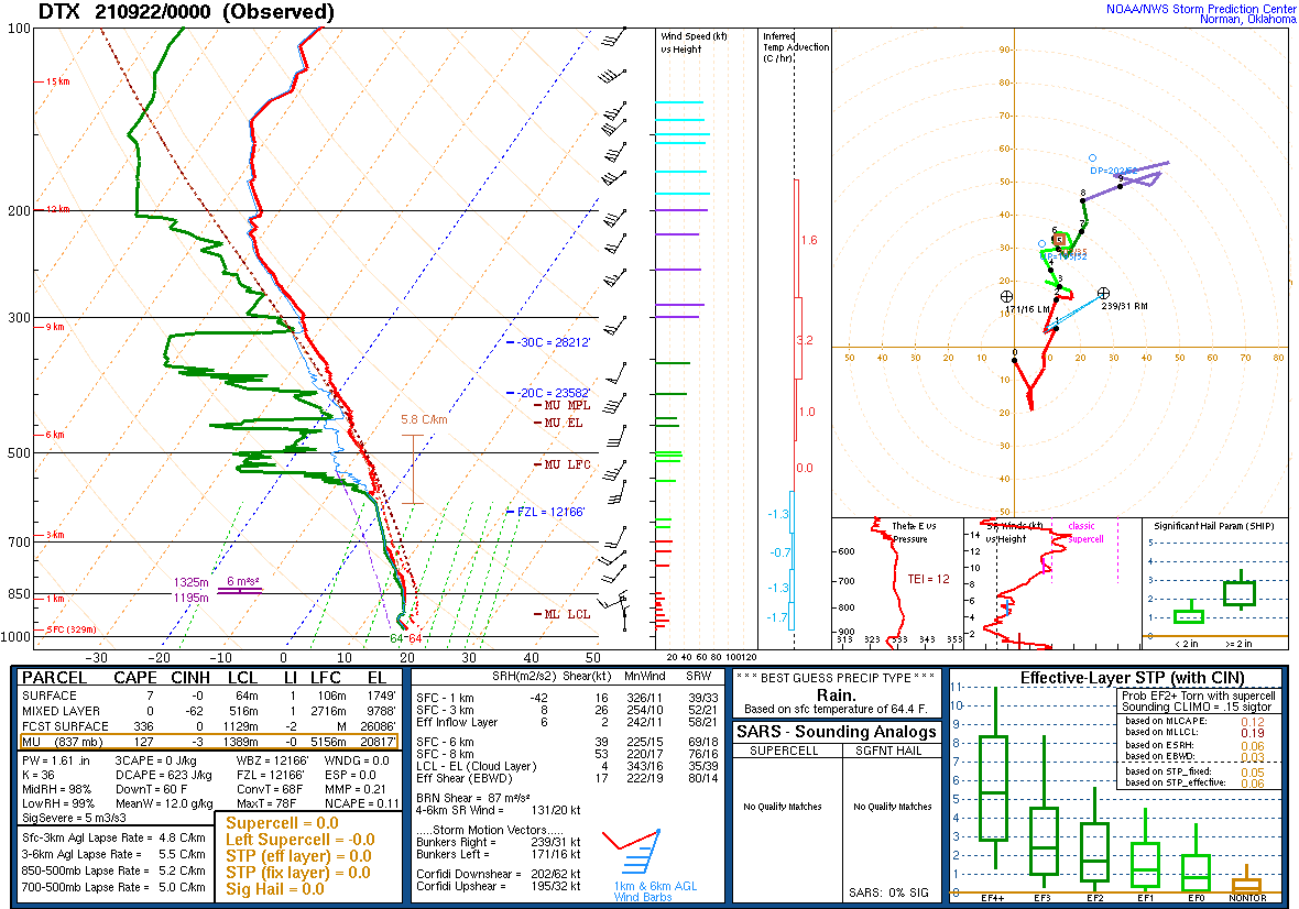
Prior to the cold frontal passage, southeast MI resided in the warm sector with southwesterly flow pushing dewpoints into the mid- to upper-60s. The upper air profile at 8 PM EDT (0000 UTC September 22) Tuesday evening showed a similar surge of moisture, with a deeply saturated profile and associated PWAT of 1.61 inches, setting the stage for heavy rainfall (Fig 2). Rainfall rates of 1-2 inches were observed in this first round of heavy rain, with rainfall totals around 2-3 inches by 11 AM EDT Wednesday morning (Fig. 3). As the cold front tracked east of the Great Lakes, a secondary low pressure system developed along the existing frontal boundary during the morning hours on Wednesday (Fig. 4). This was in response to large-scale ascent in the left exit region of the jet streak as a closed upper-level low circulated over the Ohio Valley, which contributed to sustained rainfall over southeast MI through the morning hours.
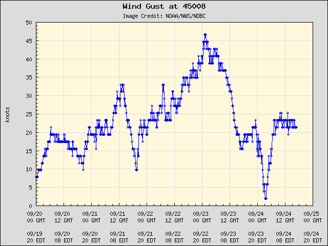
The surface low deepened as it circulated northward into the Great Lakes region, increasing wind gusts across the CWA in addition to the heavy rainfall. These winds were particularly impactful to the Lake Huron waters and nearshore counties, where buoy 45008 in middle Lake Huron observed wind gusts up to 45 kts (50+ mph) and nearshore counties observed wind gusts of 40+ mph.
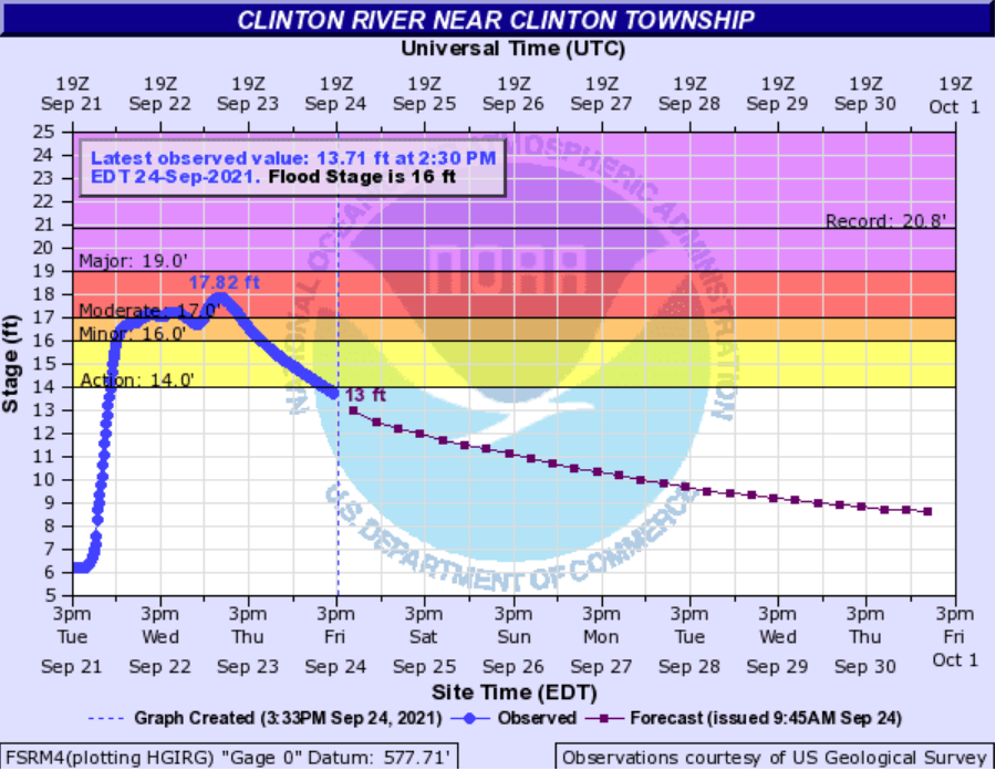
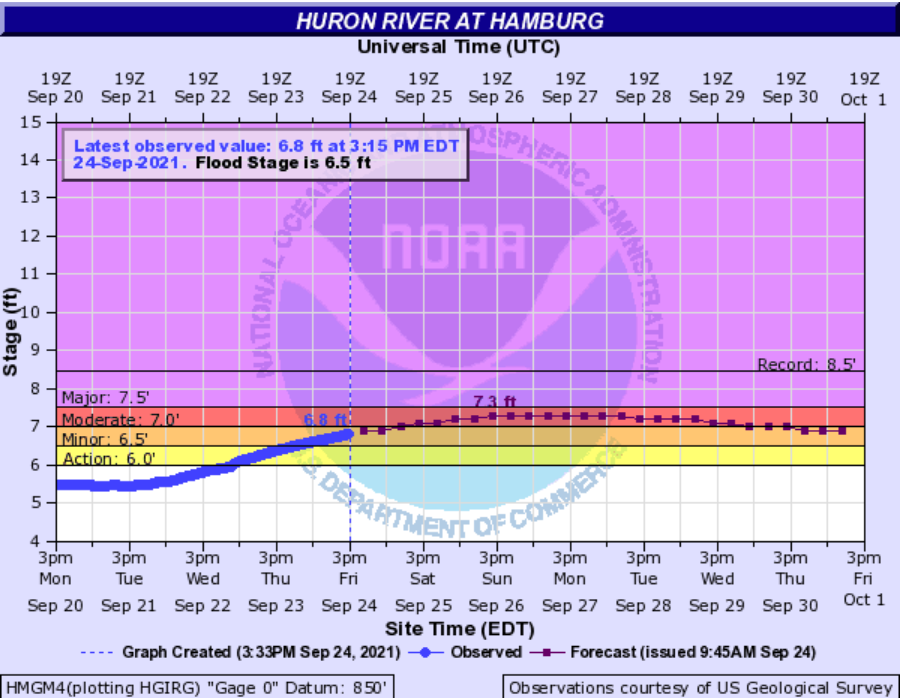
The low then began to weaken and track north of the region by Thursday morning with rainfall tapering off. Most areas received a storm total amount anywhere between 2 to 5 inches (locally 6 inches). This amount of rain caused several area rivers to rise above flood stage (Fig. 6-9).
 |
 |
 |
| Figure 1. Weather Prediction Center (WPC) surface analysis from 1800 UTC 21 September 2021. | Figure 2. KDTX upper air sounding from 0000 UTC 22 September 2021. | Figure 3. Rainfall reports (Twitter Graphic from @NWSDetroit) as of 11 AM EDT 22 September 2021. |
 |
 |
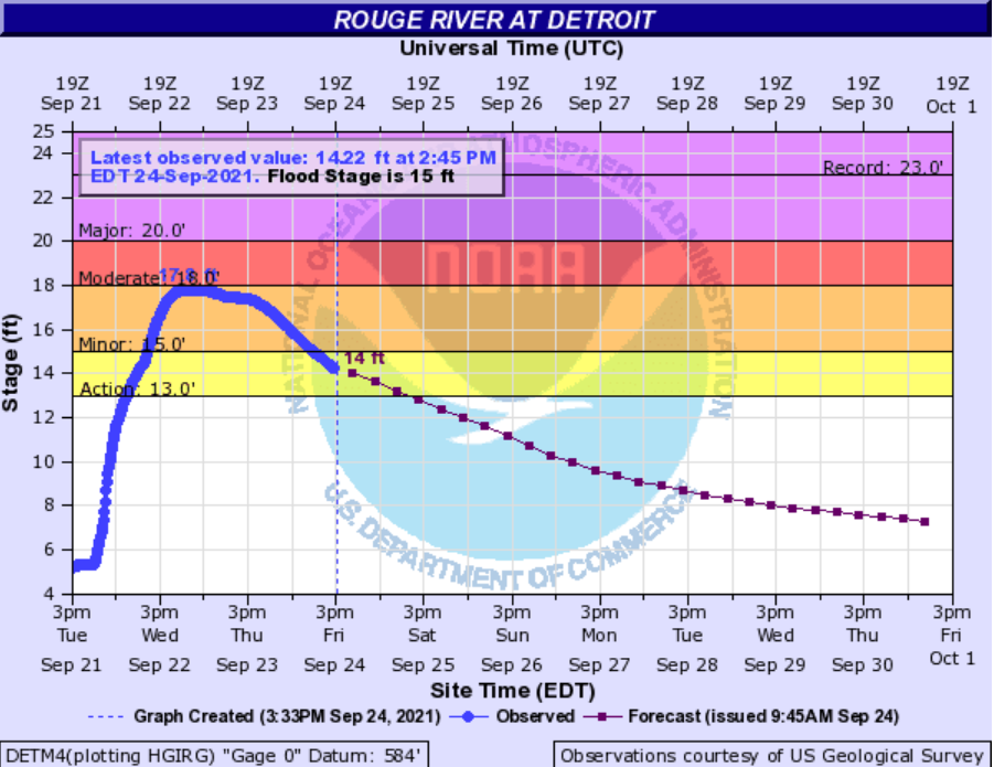 |
| Figure 4. Weather Prediction Center (WPC) surface analysis from 1800 UTC 22 September 2021. | Figure 5. Wind gusts (kts) at Buoy 45008 (middle Lake Huron) courtesy of NDBC from 0000 UTC 20 September to 0000 UTC 25 September. | Figure 6. Hydrograph showing river levels at the Rouge River at Detroit (DETM4). |
 |
 |
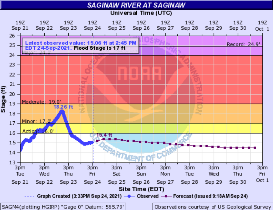 |
| Figure 7. Hydrograph showing river levels at the Clinton River near Clinton Township (FSRM4). | Figure 8. Hydrograph showing river levels at the Huron River at Hamburg (HMGM4). | Figure 9. Hydrograph showing river levels at the Saginaw River at Saginaw (SAGM4). |
 |
Media use of NWS Web News Stories is encouraged! Please acknowledge the NWS as the source of any news information accessed from this site. |
|