Overview
A very moist and unstable airmass accompanying a stalled stationary boundary resulted in multiple rounds of thunderstorms beginning during the early morning hours of August 28, 2020 and continuing into the evening hours. During the morning hours, several of these thunderstorms repeatedly trained over the same areas, resulting in 2-4+ inches of rain in just a few hours’ time and numerous reports of flooding especially in the greater Detroit metro region. As daytime instability increased during the afternoon hours, widely scattered severe thunderstorms developed producing large hail and isolated damaging winds. The stationary boundary was finally ushered east of the region during the overnight hours of August 28 into 29, 2020 as a vigorous cold front and accompanying line of strong thunderstorms moved across the region bringing an end to the much needed, but in most areas, deluge of rainfall experienced across most of southeast Michigan.
Photos
 |
 |
 |
|
Flushing Credit: Ahmad Bajjey |
Flushing Credit: Nick Dewhirst |
Royal Oak Credit: WDIV |
|
Mount Morris Township Credit: Ahmad Bajjey |
Metro Detroit Credit: WXYZ |
|
|
|
|
|
|
|
|
|
Radar
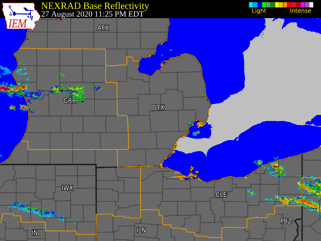  |
|
Click to Enlarge Radar loop courtesy of Iowa Environmental Mesonet (IEM) |
Storm Reports
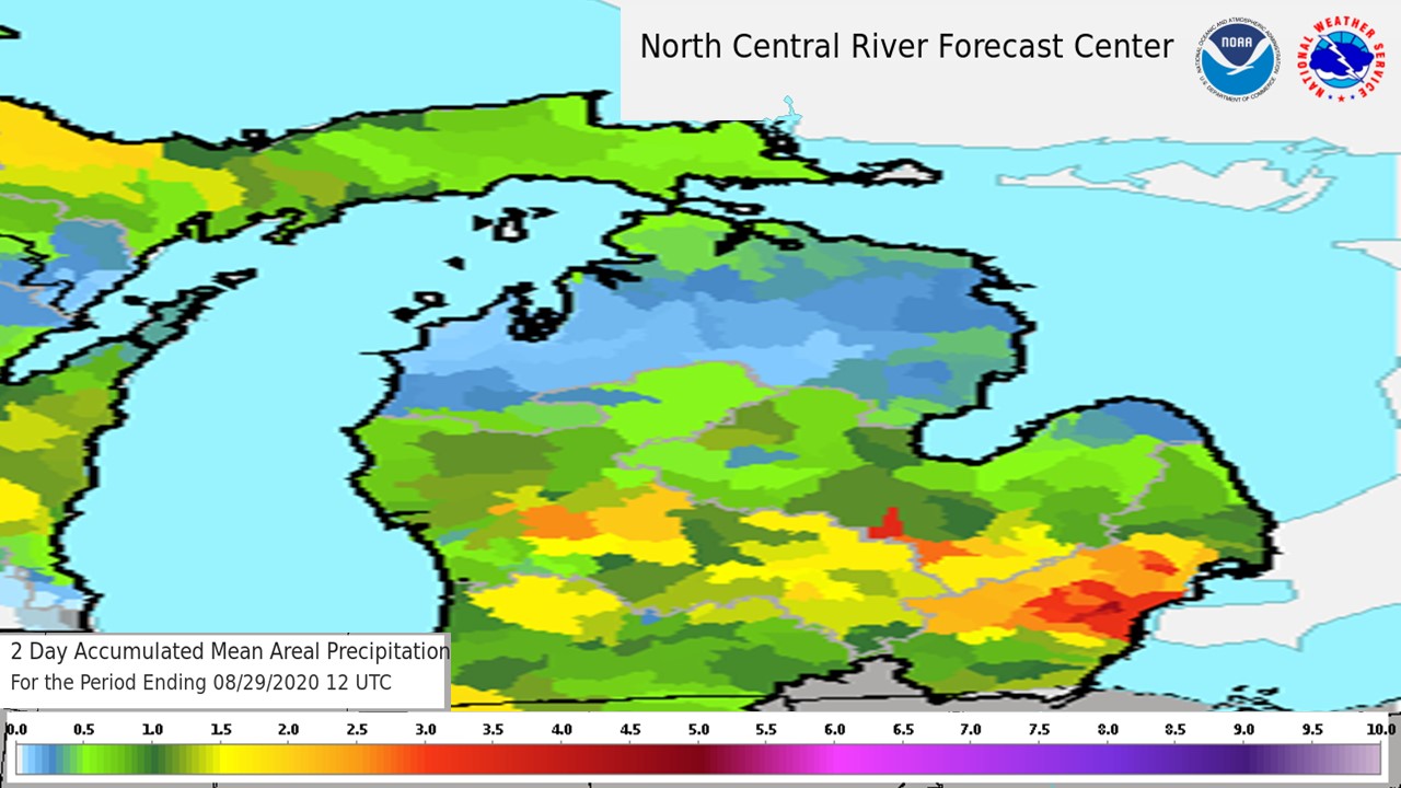
Map of observed rainfall for the 48 hour period ending 8am August 29, 2020. Map created from the North Central River Forecast Center.
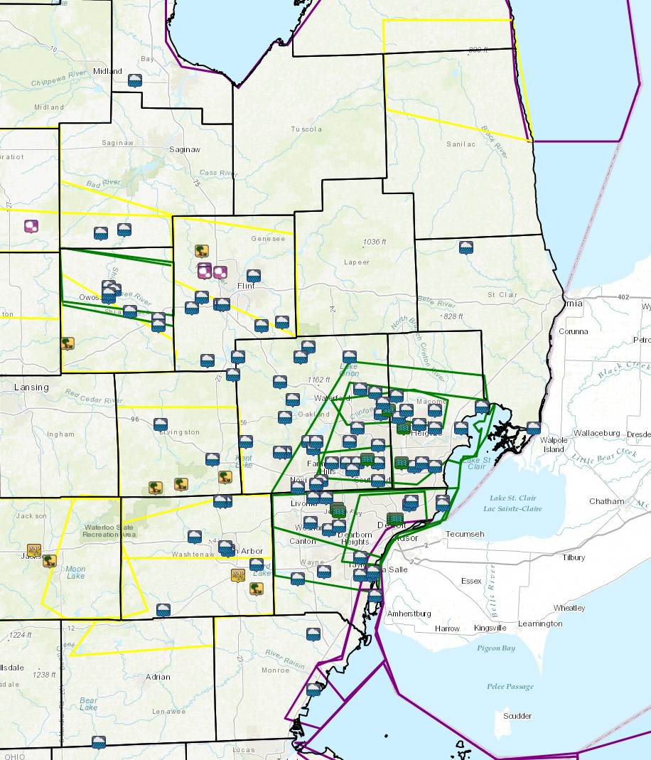
Map of wind damage, hail of 1"+, rainfall of 1"+, and flooding reports.
Severe Weather Local Storm Reports - Rainfall:
PRELIMINARY LOCAL STORM REPORT...SUMMARY
NATIONAL WEATHER SERVICE DETROIT/PONTIAC MI
1006 AM EDT SAT AUG 29 2020

..TIME...   ...EVENT...      ...CITY LOCATION...     ...LAT.LON...
..DATE...   ....MAG....      ..COUNTY LOCATION..ST.. ...SOURCE....
            ..REMARKS..

0400 AM     HEAVY RAIN       AUBURN                  43.60N 84.08W
08/29/2020  M1.06 INCH       BAY                MI   CO-OP OBSERVER

            24 HOUR RAINFALL

0400 AM     HEAVY RAIN       DURAND                  42.91N 83.99W
08/29/2020  M2.65 INCH       SHIAWASSEE         MI   CO-OP OBSERVER

            24 HOUR RAINFALL

0400 AM     HEAVY RAIN       OWOSSO                  43.00N 84.18W
08/29/2020  M4.91 INCH       SHIAWASSEE         MI   CO-OP OBSERVER

            24 HOUR RAINFALL

0400 AM     HEAVY RAIN       4 N BURTON              43.05N 83.62W
08/29/2020  M1.54 INCH       GENESEE            MI   CO-OP OBSERVER

            24 HOUR RAINFALL

0400 AM     HEAVY RAIN       FARMINGTON              42.46N 83.38W
08/29/2020  M3.24 INCH       OAKLAND            MI   CO-OP OBSERVER

            24 HOUR RAINFALL

0400 AM     HEAVY RAIN       1 SE ANN ARBOR          42.27N 83.72W
08/29/2020  M2.81 INCH       WASHTENAW          MI   CO-OP OBSERVER

            24 HOUR RAINFALL

0400 AM     HEAVY RAIN       MORENCI                 41.72N 84.22W
08/29/2020  M1.59 INCH       LENAWEE            MI   CO-OP OBSERVER

            24 HOUR RAINFALL

0400 AM     HEAVY RAIN       SSE SHELBY TOWNSHIP     42.67N 83.03W
08/29/2020  M3.85 INCH       MACOMB             MI   COCORAHS

            24 HOUR RAINFALL

0400 AM     HEAVY RAIN       2 NNE SOUTHFIELD        42.50N 83.24W
08/29/2020  M4.14 INCH       OAKLAND            MI   COCORAHS

            24 HOUR RAINFALL

0400 AM     HEAVY RAIN       2 E UTICA               42.63N 82.98W
08/29/2020  M3.21 INCH       MACOMB             MI   COCORAHS

            24 HOUR RAINFALL

0400 AM     HEAVY RAIN       2 N CLINTON             42.10N 83.97W
08/29/2020  M2.92 INCH       WASHTENAW          MI   COCORAHS

            24 HOUR RAINFALL

0400 AM     HEAVY RAIN       1 NW DEARBORN HEIGHTS   42.34N 83.29W
08/29/2020  M3.71 INCH       WAYNE              MI   COCORAHS

            24 HOUR RAINFALL

0400 AM     HEAVY RAIN       2 S ORTONVILLE          42.82N 83.44W
08/29/2020  M2.00 INCH       OAKLAND            MI   COCORAHS

            24 HOUR RAINFALL

0400 AM     HEAVY RAIN       4 WSW CHESANING         43.17N 84.21W
08/29/2020  M1.00 INCH       SAGINAW            MI   TRAINED SPOTTER

            24 HOUR RAINFALL

0400 AM     HEAVY RAIN       BRIGHTON                42.53N 83.78W
08/29/2020  M1.60 INCH       LIVINGSTON         MI   TRAINED SPOTTER

            24 HOUR RAINFALL

0400 AM     HEAVY RAIN       BLOOMFIELD HILLS        42.58N 83.25W
08/29/2020  M2.37 INCH       OAKLAND            MI   TRAINED SPOTTER

            24 HOUR RAINFALL

0400 AM     HEAVY RAIN       2 ESE BELLEVILLE        42.19N 83.45W
08/29/2020  M3.28 INCH       WAYNE              MI   COCORAHS

            24 HOUR RAINFALL

0400 AM     HEAVY RAIN       2 SE DEXTER             42.31N 83.85W
08/29/2020  M2.59 INCH       WASHTENAW          MI   COCORAHS

            24 HOUR RAINFALL

0400 AM     HEAVY RAIN       1 N GROSSE ILE          42.14N 83.15W
08/29/2020  M2.24 INCH       WAYNE              MI   COCORAHS

            24 HOUR RAINFALL

0400 AM     HEAVY RAIN       2 SE DEXTER             42.31N 83.85W
08/29/2020  M2.59 INCH       WASHTENAW          MI   COCORAHS

            24 HOUR RAINFALL

0400 AM     HEAVY RAIN       3 S MONROE              41.87N 83.39W
08/29/2020  M1.30 INCH       MONROE             MI   COCORAHS

            24 HOUR RAINFALL

0400 AM     HEAVY RAIN       2 S CARLETON            42.03N 83.39W
08/29/2020  M1.20 INCH       MONROE             MI   COCORAHS

            24 HOUR RAINFALL

0400 AM     HEAVY RAIN       CHESANING               43.18N 84.12W
08/29/2020  M1.11 INCH       SAGINAW            MI   CO-OP OBSERVER

            24 HOUR RAINFALL

0400 AM     HEAVY RAIN       GOODRICH                42.92N 83.51W
08/29/2020  M1.20 INCH       GENESEE            MI   CO-OP OBSERVER

            24 HOUR RAINFALL

0400 AM     HEAVY RAIN       YALE                    43.13N 82.80W
08/29/2020  M1.01 INCH       ST. CLAIR          MI   CO-OP OBSERVER

            24 HOUR RAINFALL

0400 AM     HEAVY RAIN       GROSSE POINTE FARMS     42.40N 82.89W
08/29/2020  M2.23 INCH       WAYNE              MI   CO-OP OBSERVER

            24 HOUR RAINFALL

0400 AM     HEAVY RAIN       SSE NEW BALTIMORE       42.68N 82.74W
08/29/2020  M1.86 INCH       MACOMB             MI   COCORAHS

            24 HOUR RAINFALL

0400 AM     HEAVY RAIN       6 ENE DETROIT           42.41N 83.01W
08/29/2020  M2.69 INCH       WAYNE              MI   ASOS

            24 HOUR RAINFALL AT CITY AIRPORT

0400 AM     HEAVY RAIN       1 SE ROMULUS            42.21N 83.35W
08/29/2020  M3.28 INCH       WAYNE              MI   ASOS

            24 HOUR RAINFALL AT METRO AIRPORT

0400 AM     HEAVY RAIN       5 SSW FLINT             42.97N 83.74W
08/29/2020  M1.98 INCH       GENESEE            MI   ASOS

            24 HOUR RAINFALL AT FLINT BISHOP AIRPORT

0400 AM     HEAVY RAIN       5 ESE FOWLERVILLE       42.63N 83.98W
08/29/2020  M1.14 INCH       LIVINGSTON         MI   ASOS

            24 HOUR RAINFALL AT HOWELL AIRPORT

0400 AM     HEAVY RAIN       WYANDOTTE               42.21N 83.16W
08/29/2020  M3.89 INCH       WAYNE              MI   CO-OP OBSERVER

            24 HOUR RAINFALL

0400 AM     HEAVY RAIN       4 SW CLARKSTON          42.70N 83.47W
08/29/2020  M2.13 INCH       OAKLAND            MI   OFFICIAL NWS OBS

            24 HOUR RAINFALL AT NWS WHITE LAKE OFFICE

0400 AM     HEAVY RAIN       ANN ARBOR               42.28N 83.73W
08/29/2020  M1.66 INCH       WASHTENAW          MI   OFFICIAL NWS OBS

            24 HOUR RAINFALL


&&
RAIN FELL IN MULTIPLE ROUNDS OVER THE COURSE OF AUGUST 28TH WITH
LOCATIONS SEEING RAIN STARTING AFTER MIDNIGHT LASTING INTO THE
MORNING. THIS ROUND HAD THE HIGHEST TOTALS OUT OF ANY OF THE ROUNDS.
A SECOND ROUND OF SCATTERED STORMS DEVELOPED IN THE AFTERNOON/EVENING
WITH THE THIRD AND FINAL ROUND COMING OVERNIGHT THE 28-29TH. OVERALL
THE ROUGH DURATION OF RAINFALL WAS OVER 24 HOURS, GIVE OR TAKE AN
HOUR DEPENDING ON THE EXACT LOCATION.
$$
Severe Weather Local Storm Reports - Severe:
..TIME... ...EVENT... ...CITY LOCATION... ...LAT.LON...
..DATE... ....MAG.... ..COUNTY LOCATION..ST.. ...SOURCE....
..REMARKS..
0200 PM TSTM WND GST 6 SSE ANN ARBOR 42.20N 83.68W
08/28/2020 E50 MPH WASHTENAW MI EMERGENCY MNGR
ESTIMATED 50 MPH WIND GUSTS REPORTED. SMALL LIMBS DOWN.
0300 PM TSTM WND GST 6 SSE ANN ARBOR 42.20N 83.68W
08/28/2020 E50 MPH WASHTENAW MI EMERGENCY MNGR
ESTIMATED 50 MPH WIND GUSTS REPORTED. SMALL LIMBS DOWN.
0320 PM TSTM WND DMG 2 W WILLIS 42.16N 83.61W
08/28/2020 Washtenaw MI TRAINED SPOTTER
REPORT OF LARGE 10 INCH BRANCH DOWN PARTIALLY COVERING
WESTBOUND WILLIS RD NEAR WHITTAKER RD.
0502 PM TSTM WND DMG 4 NNE FLUSHING 43.12N 83.82W
08/28/2020 Genesee MI BROADCAST MEDIA
MEDIA PASSED ALONG A PHOTO OF SNAPPED TREE
0505 PM HAIL 1 E FLUSHING 43.07N 83.81W
08/28/2020 M1.25 INCH GENESEE MI TRAINED SPOTTER
0507 PM HAIL 1 ESE FLUSHING 43.06N 83.81W
08/28/2020 M1.75 INCH GENESEE MI TRAINED SPOTTER
0508 PM HAIL 4 NW FLINT 43.06N 83.75W
08/28/2020 M1.00 INCH GENESEE MI BROADCAST MEDIA
0510 PM HAIL 2 ESE FLUSHING 43.06N 83.81W
08/28/2020 M2.00 INCH GENESEE MI AIRPLANE PILOT
1135 PM TSTM WND DMG 2 SSE LAINGSBURG 42.86N 84.34W
08/28/2020 SHIAWASSEE MI 911 CALL CENTER
TREES DOWN.
1239 AM TSTM WND DMG 3 W PINCKNEY 42.45N 84.00W
08/29/2020 LIVINGSTON MI 911 CALL CENTER
COUNTY DISPATCH REPORTS TREES DOWN NEAR MONKS AND KELLY
RDS
1250 AM TSTM WND DMG 2 E PINCKNEY 42.46N 83.90W
08/29/2020 LIVINGSTON MI 911 CALL CENTER
COUNTY DISPATCH REPORTS TREES DOWN NEAR MCGREGOR RD SOUTH
OF M36
1252 AM TSTM WND DMG 4 SE BRIGHTON 42.48N 83.73W
08/29/2020 LIVINGSTON MI 911 CALL CENTER
COUNTY DISPATCH REPORTS A TREE DOWN ALONG PIER RD.
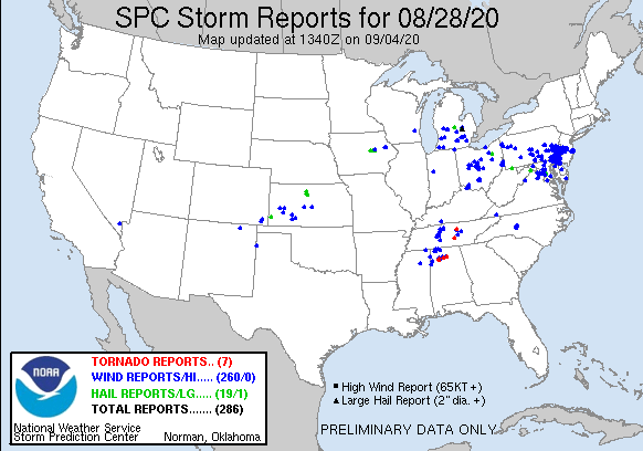
National Storm Reports (for August 28, 2020):
Environment
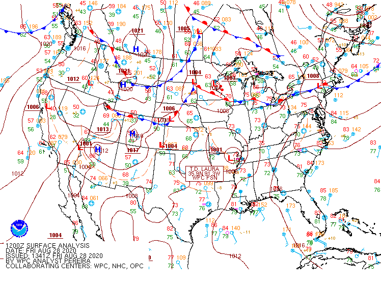
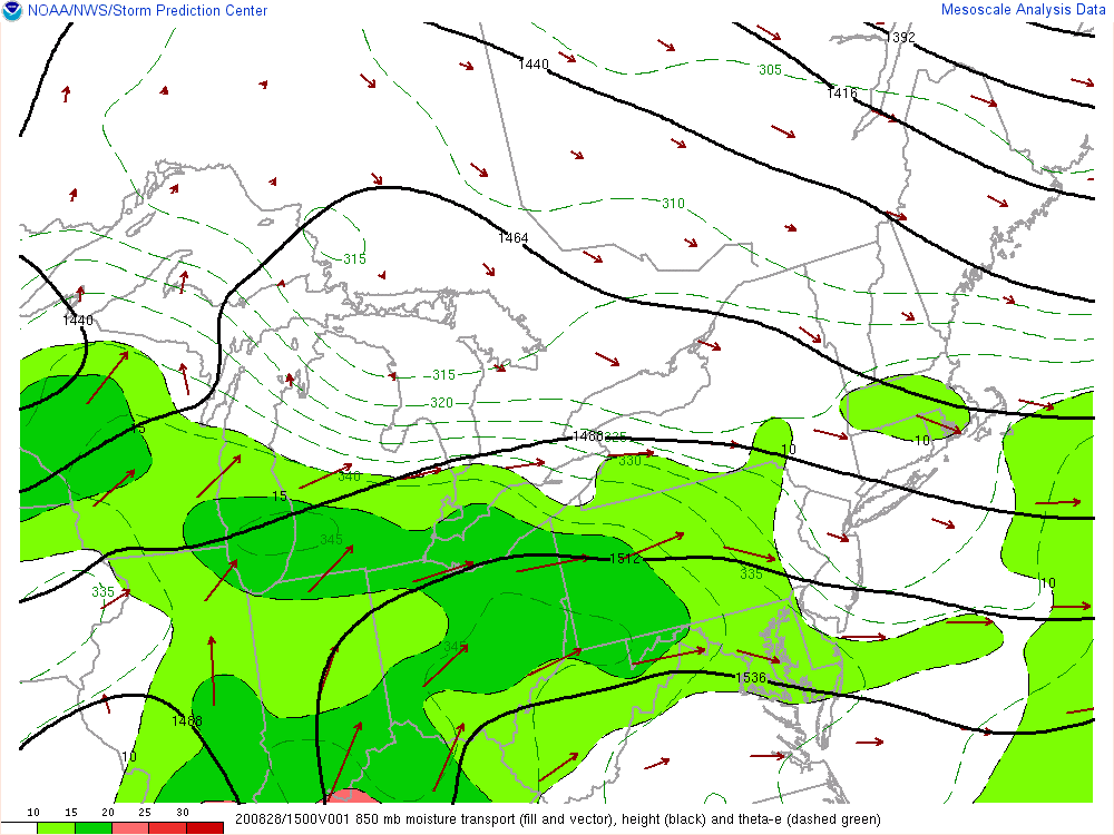
Throughout August 27, 2020 and continuing through August 28, a stationary boundary remained draped west to east just north of the Ohio/Indiana border (Fig. 1). A continuous feed of anomalously high moisture content advected from south to north across the front into southeast Michigan, as evident by the 850 hPa moisture propagation vectors valid during the morning hours August 28 (Fig. 2). This feed of moisture allowed for PWATs to increase to well over 1.75 inches along with surface dewpoints reaching into the lower 70s F. In addition to the abundant supply of moisture, plentiful elevated instability was also transported north of the stationary boundary during the early morning hours of August 28 which helped fuel the initial development of clusters of thunderstorms that first tracked into Shiawassee County shortly after midnight. Within just 2 hours, it was clearly evident that heavy rain was going to be a significant early morning threat as rainfall totals approaching 4 inches quickly came in.
Additional thunderstorms developing in the unstable nocturnal moist environment quickly enveloped the greater Detroit metro region shortly thereafter, and similarly resulted in swaths of 2-4+ inches of rain in the 3-8am timeframe. It was during this time that several flooding reports began to emerge in the greater Detroit metro region, with numerous road closures due to flooded roadways and intersections including major freeways such as I-94 and I-96.
The 12 UTC 8/28 KDTX observed sounding (Fig. 3) revealed several notable characteristics typical in heavy rainfall environmental regimes. First, there was plentiful moisture available with a noted PWAT of 1.80 inches, which was above the 90th percentile for the date according to the Storm Prediction Center PWAT climatology (not shown). The sounding revealed sufficient instability (MUCAPE ~1100 J/kg) within a favored tall, skinny CAPE profile characteristic of heavy rain soundings (Note: a “fat” profile is more favorable for hail). The freezing level was not particularly high (12.6 kft), but the wet bulb zero height was notable (12.5 kft). Lapse rates through the lowest 400 hPa were moist adiabatic, indicating favorable deep, moist adiabatic ascent through most of the atmospheric column. And finally, there was sufficient deep layer shear (0-6 km ~35 kt) amidst a unidirectional wind profile and straight hodograph to support splitting multicells that favoring a tendency to train over the same areas.
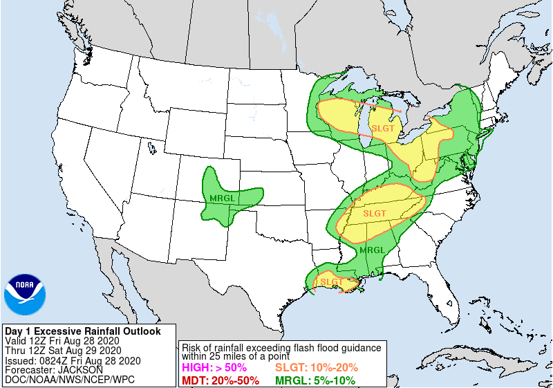
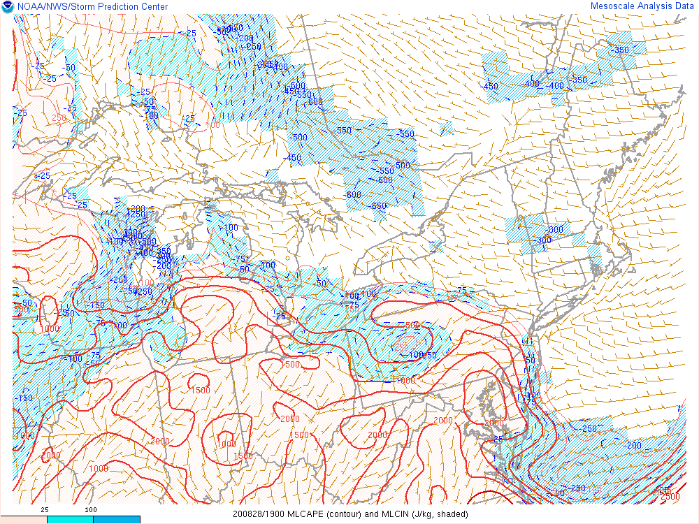
Throughout the remainder of the day, rounds of thunderstorms continued to develop amidst the moist and unstable airmass. The Weather Prediction Center highlighted the heavy rainfall threat well for southeast Michigan, with a Slight Risk indication for excessive rainfall (Fig. 4). As the day progressed into the afternoon, however, early morning cloud cover began to erode allowing more sunshine to increase daytime heating and instability. As Figure 5 depicts, by mid-afternoon, MLCAPE across most of southeast Michigan had easily reached around 1500 J/kg – more than sufficient for renewed vigorous thunderstorm development. In addition to the heavy rainfall threat the entire day, the Storm Prediction Center had the region highlighted in a Slight Risk for severe thunderstorms (not shown), with damaging winds and large hail as the primary threats. As can often be the case in southeast Michigan, when there is at least 1500 J/kg of instability combined with at least 30 kt of shear (Fig. 6) and 70+ F surface dewpoints, severe thunderstorms are certainly plausible especially should they form during peak heating in the mid-afternoon to early evening hours.
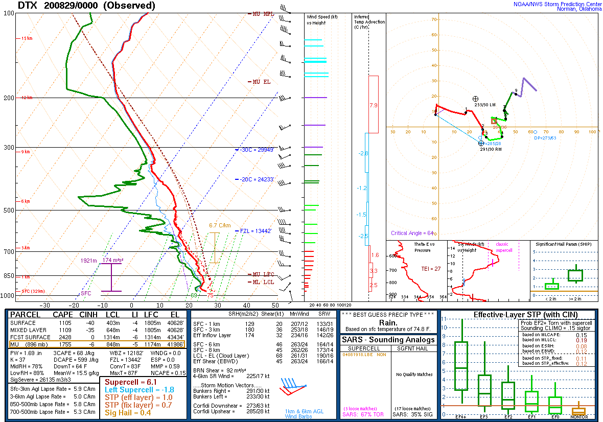
That is exactly what happened. During the afternoon hours, widely scattered severe thunderstorms developed across portions of southeast Michigan producing damaging winds and most notably, large hail. A few reports of golf ball and larger size hail near Flint were reported with severe thunderstorms that rolled through during the evening rush hour, while further south in the vicinity of the I-94 corridor, reports of wind damage were observed. The 00 UTC 8/29 KDTX observed sounding (Fig. 7) revealed a more favorable sounding for severe weather, with increased 0-6 km deep layer shear approaching 50 kt, MUCAPE approaching 2000 J/kg, and a slightly curved hodograph.
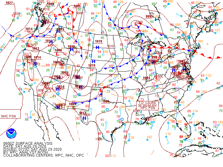
After these severe thunderstorms waned during the evening hours, a brief lull in activity was experienced during the early overnight hours. This lull was short-lived, however, as a vigorous cold front (Fig. 9) and attendant line of strong to severe thunderstorms quickly raced across lower Michigan during the overnight and early morning hours of August 29. A brief Severe Thunderstorm Watch was issued for south-central lower Michigan as these thunderstorms went through before all activity exited east of the region by 5am and much cooler and drier conditions were quickly ushered in from the west.
Click on the images below to see them expanded.
 |
 |
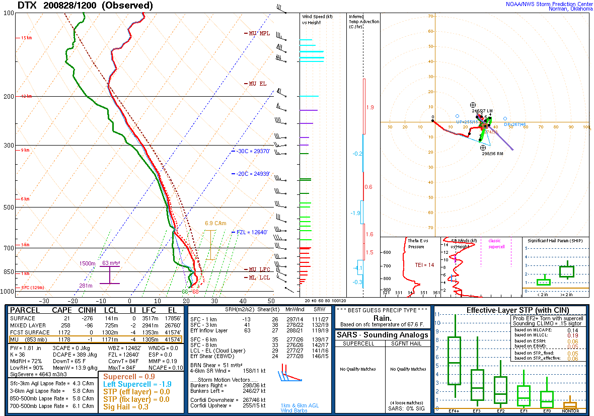 |
| Figure 1: Weather Prediction Center (WPC) surface map, valid 12 UTC 28 August 2020. | Figure 2: Storm Prediction Center (SPC) 850 hPa moisture propagation vector map, valid 14 UTC 28 August 2020. | Figure 3: KDTX observed sounding, valid 12 UTC 28 August 2020. |
 |
 |
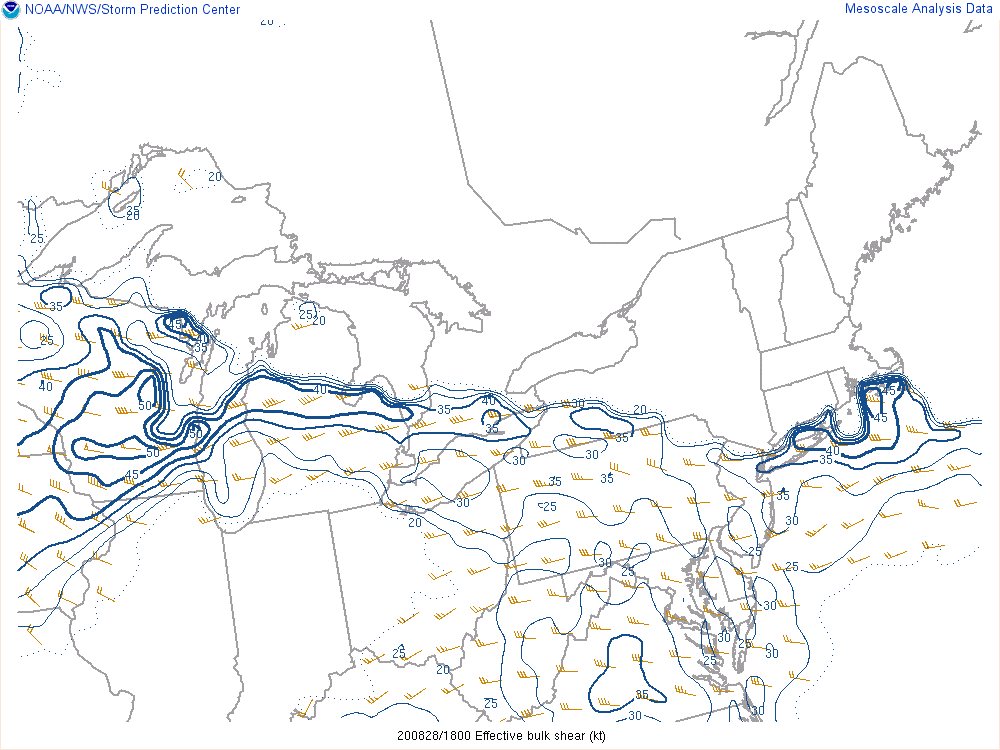 |
| Figure 4: WPC Day 1 Excessive Rainfall Outlook graphic, valid 28 August 2020. | Figure 5: SPC MLCAPE mesoanalysis, valid 19 UTC 28 August 2020. | Figure 6: SPC effective bulk shear mesoanalysis, valid 18 UTC 28 August 2020. |
 |
 |
|
| Figure 7: KDTX observed sounding, valid 00 UTC 29 August 2020. | Figure 8: WPC surface map, valid 06 UTC 29 August 2020. |
 |
Media use of NWS Web News Stories is encouraged! Please acknowledge the NWS as the source of any news information accessed from this site. |
|