Overview
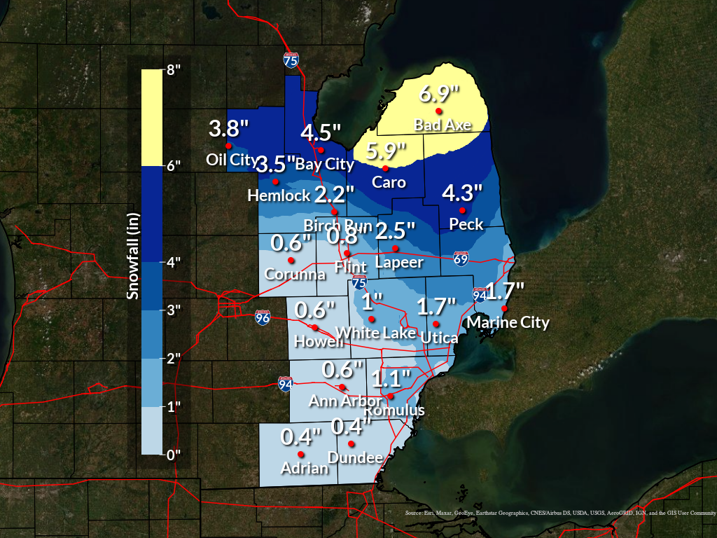
Two weather systems tracked through the Great Lakes region and the Ohio Valley on Saturday (Feb 8). Much of southeast Michigan received just a glancing blow from the two systems, with half an inch to one and half inches of snow along and south of I-69, along with some freezing drizzle/ice pellets south of M-59. The brunt of the northern system was experienced north of I-69, with 3-6 inches of snow reported, with even higher reports over Huron county where 7-8 inches were received. Just about all measurable snowfall occurred between 1 PM Saturday - 1 AM Sunday.
Snow Totals
Public Information Statement...Summary
National Weather Service Detroit/Pontiac MI
1156 AM EST Sun Feb 9 2025


STORM TOTAL SNOW REPORTS

Location                  Snowfall     Duration
                          (Inches)      (Hours)        Lat       Lon

...Bay County...
   2 NE Auburn             M   3.6           12     43.62N    84.05W
   2 E Bay City            M   3.7           12     43.59N    83.85W
   3 NW Bay City           M   4.0           12     43.62N    83.93W

...Genesee County...
   Flint                   M   0.8           12     43.02N    83.69W
   4 N Burton              M   1.2           12     43.05N    83.62W
   3 SE Grand Blanc        M   1.6           12     42.90N    83.58W
   Goodrich                M   1.6           12     42.92N    83.51W

...Huron County...
   Bad Axe                 M   6.4           12     43.80N    83.00W
   Harbor Beach            M   6.8           14     43.85N    82.65W
   Port Austin             M   8.0           12     44.04N    83.00W

...Lapeer County...
   Lapeer                  M   1.3           12     43.05N    83.32W
   Lapeer                  M   1.8           12     43.05N    83.32W
   5 W Lapeer              M   2.0           12     43.05N    83.42W

...Lenawee County...
   Morenci                 M   0.4           12     41.72N    84.22W

...Macomb County...
   2 NE Roseville          M   0.8           12     42.51N    82.91W
   Eastpointe              M   1.7           12     42.47N    82.96W

...Midland County...
   Midland                 M   4.2           12     43.62N    84.23W

...Oakland County...
   1 NW Pleasant Ridge     M   0.8           12     42.47N    83.14W
   Farmington              M   0.9           12     42.46N    83.38W
   2 NW Waterford          M   1.0           12     42.68N    83.42W
   2 S Ortonville          M   1.0           12     42.82N    83.44W
   4 E White Lake          M   1.0           12     42.65N    83.43W
   Waterford               M   1.0           12     42.66N    83.39W

...Saginaw County...
   Chesaning               M   1.8           12     43.18N    84.12W

...Sanilac County...
   Lexington               M   3.0           12     43.27N    82.53W
   2 W Peck                M   3.3           12     43.26N    82.86W

...Shiawassee County...
   6 NW Durand             M   0.3           12     42.98N    84.08W
   Owosso                  M   0.5           12     43.00N    84.18W

...St. Clair County...
   Algonac                 M   2.0           12     42.62N    82.53W

...Tuscola County...
   Cass City               M   5.5           12     43.60N    83.18W
   Cass City               M   5.5           12     43.60N    83.18W

...Washtenaw County...
   Manchester              M   0.4           12     42.15N    84.04W
   4 SW Saline             M   0.5           12     42.13N    83.84W
   Se Ann Arbor            M   0.8           12     42.28N    83.73W

...Wayne County...
   2 NW Dearborn Heights   M   0.8           12     42.36N    83.30W
   1 NE Detroit            M   0.9           12     42.33N    83.05W
   2 SE Romulus            M   1.1           12     42.20N    83.34W
   2 NW Livonia            M   1.2           12     42.42N    83.40W
   Wyandotte               M   1.2           12     42.21N    83.15W
   Grosse Pointe Farms     M   2.0           12     42.41N    82.89W


M = Measured
E = Estimated

$$
|
|
|
Estimated snowfall totals across Southeast Michigan from the February 8-9 2025 storm. |
Radar
|
|
|
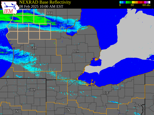
Radar: NEXRAD mosaic base reflectivity radar loop from February 8-9, 2025 |
Radar loop courtesy of Iowa Environmental Mesonet (IEM)
 |
Media use of NWS Web News Stories is encouraged! Please acknowledge the NWS as the source of any news information accessed from this site. |
|