Overview
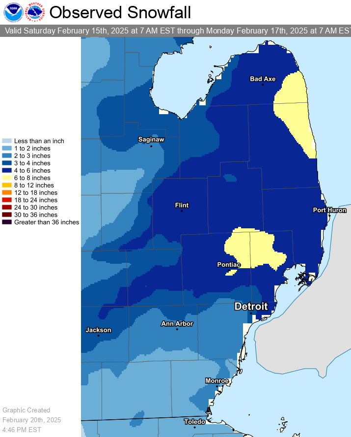
An extended period of wintry conditions was observed across Southeast Michigan from early in the morning of Saturday, February 15 into the evening hours Sunday, February 16. This occurred as a complex and broad low pressure system developed over the Tennessee and Ohio Valleys Saturday night before tracking up the eastern seaboard on Sunday. This system brought severe weather to the Southeast U.S. and 2 to 6+ inches of rain across much of the Tennessee/Ohio Valleys resulting in deadly, widespread flooding. A summary of the impacts in Kentucky can be found here. Locally, we saw several episodes of snowfall from this system with intervals of ice pellets and freezing drizzle/mist. 36-hour snowfall totals ranging from 1 to 4 inches across the south and Metro Detroit, to 4 to 6 inches across the Thumb, Flint vicinity, and northern Metro Detroit suburbs.
An initial band of light snow developed during the evening of Friday, February 14, but had to contend with a layer of dry air below 10,000 ft. This band eventually began to reach the ground around midnight and dropped a few tenths of an inch before sunrise Saturday. Moisture advection and frontogenesis aloft caused additional bands of snow, heavy at times, to develop overhead during the mid-morning hours and persist into the afternoon. Much of this was focused along and north of M-59. Dry air then began to work back in from the south, causing ice nuclei to be stripped from the cloud layer and resulting in freezing drizzle for much of the area through the afternoon before changing back to light snow by the evening. This light snow tapered off by midnight Sunday as the next phase of the event took shape upstream.
The center of low pressure tracked up the spine of the Appalachians on Sunday, placing Southeast Michigan within the far western extent of the system's strong deformation located in its northwest quadrant. This forcing caused a band of snow to redevelop early Sunday morning and persist through the mid-morning hours before moving out as the system began to reach New England. Additional snow showers then developed Sunday afternoon as the system pulled a cold front through. Behind this front, winds became gusty and reached 30 to 40 mph across much of the area. This combined with the snow showers and fresh snow was able to produce areas of blowing snow Sunday night into Monday. Additional lake effect snow showers streamed across the state Sunday evening into Monday, bringing localized accumulations of 1 to 2 inches.
Snow Totals
Public Information Statement...Summary
National Weather Service Detroit/Pontiac MI
1148 AM EST Sun Feb 16 2025


STORM TOTAL SNOW REPORTS

Location                  Snowfall     Duration
                          (Inches)      (Hours)        Lat       Lon

...Genesee County...
   Flint Bishop Intl Airpo M   3.7           36     42.97N    83.75W
   Goodrich                M   4.5           36     42.92N    83.51W

...Huron County...
   Filion                  M   3.4           36     43.90N    83.00W
   Bad Axe                 M   4.1           36     43.80N    83.00W

...Lenawee County...
   Morenci                 M   2.3           36     41.72N    84.22W

...Livingston County...
   1 NE Howell             M   3.5           36     42.62N    83.92W

...Macomb County...
   Eastpointe              M   3.5           36     42.47N    82.96W
   Macomb Township         M   4.0           36     42.67N    82.92W
   Richmond                M   6.1           36     42.81N    82.75W
   Washington              M   6.1           36     42.72N    83.04W

...Midland County...
   Oil City                M   2.2           36     43.61N    84.59W

...Oakland County...
   Berkley                 M   3.5           36     42.50N    83.18W
   2 SW Wolverine Lake     M   4.5           36     42.54N    83.50W
   4 E White Lake          M   4.5           36     42.65N    83.43W
   Lake Orion              M   6.4           36     42.78N    83.24W

...Saginaw County...
   Tri Cities Intl Airport M   3.1           36     43.53N    84.08W

...Sanilac County...
   Lexington               M   4.0           24     43.27N    82.53W
   2 W Peck                M   6.0           36     43.26N    82.86W

...St. Clair County...
   3 SW Port Huron         M   4.0           36     42.97N    82.47W

...Tuscola County...
   Cass City               M   3.5           36     43.60N    83.18W

...Washtenaw County...
   Ann Arbor               M   2.3           36     42.28N    83.73W
   4 SW Saline             M   3.2           36     42.13N    83.84W
   4 NE Chelsea            M   3.9           36     42.35N    83.97W

...Wayne County...
   Grosse Pointe Farms     M   3.0           36     42.41N    82.89W
   5 NE Detroit            M   3.2           36     42.38N    82.98W
   Livonia                 M   3.2           36     42.40N    83.37W
   2 SE Romulus            M   4.6           36     42.20N    83.34W
   Wyandotte               M   4.8           36     42.21N    83.15W


M = Measured
E = Estimated

$$
|
|
|
Estimated snowfall totals across Southeast Michigan from the February 15 to 16, 2025 storm. |
Wind Gusts
Public Information Statement
National Weather Service Detroit/Pontiac MI
532 PM EST Mon Feb 17 2025

...HIGHEST WIND REPORTS OVER THE PAST TWO DAYS...

Location                     Speed     Time/Date       Lat/Lon
Detroit Metro Airport        44 MPH    0105 PM 02/17   42.23N/83.33W
Detroit Willow Run Airport   41 MPH    0854 PM 02/16   42.23N/83.53W
Pontiac                      41 MPH    1214 PM 02/17   42.67N/83.42W
Detroit Grosse Ile           39 MPH    0817 PM 02/16   42.10N/83.15W
Adrian                       38 MPH    0853 PM 02/16   41.87N/84.08W
Flint Bishop Airport         38 MPH    0253 PM 02/17   42.97N/83.75W
Detroit City Airport         37 MPH    0709 PM 02/16   42.40N/83.02W
Selfridge Airforce Base      37 MPH    0149 PM 02/17   42.62N/82.82W
Saginaw County H W Browne    36 MPH    1106 AM 02/17   43.43N/83.87W
Ann Arbor                    35 MPH    1218 PM 02/17   42.22N/83.74W
Howell                       35 MPH    0815 PM 02/16   42.62N/83.97W
Saginaw                      35 MPH    1219 PM 02/17   43.53N/84.08W
Owosso                       33 MPH    1235 PM 02/17   43.00N/84.13W
Monroe                       32 MPH    0320 PM 02/17   41.93N/83.42W
Troy Oakland                 32 MPH    1214 PM 02/17   42.55N/83.18W
Lapeer                       31 MPH    0235 PM 02/17   43.07N/83.27W
Bad Axe                      30 MPH    0115 PM 02/17   43.78N/82.98W
Midland Barstow              30 MPH    0348 PM 02/17   43.67N/84.27W
Caro Tuscola                 29 MPH    1155 AM 02/17   43.47N/83.45W

These observations were collected from the ASOS/AWOS`s across
southeast Michigan. Not all data listed are considered official.

$$
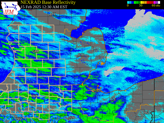
Radar
|
|
|
Radar: NEXRAD mosaic base reflectivity radar loop from February 15 to 17, 2025 |
Radar loop courtesy of Iowa Environmental Mesonet (IEM)
 |
Media use of NWS Web News Stories is encouraged! Please acknowledge the NWS as the source of any news information accessed from this site. |
|