Overview
An organized line of thunderstorms brought widespread strong to severe thunderstorms across SE MI through the afternoon and evening hours. Thunderstorms initially became more organized across the Tri-Cities and northern Thumb during the early afternoon and brought widely scattered wind gusts between 50-60 mph, which resulted in numerous reports of downed trees and powerlines. Severe thunderstorms continued to expand southward during the late afternoon, while new storms developed just ahead of the initial line, along an expanding outflow boundary. Given the moderate to strong instability in place, thunderstorms continued to produce widely scattered damaging wind gusts as they approached the northern Metro region. A Mesoscale Convective Vortex (MCV) eventually caught up with the line in the evening hours which continued the threat of severe weather across the Metro region. Over 100,000 homes and businesses were without power after the thunderstorms moved through. For an addition in-depth environmental overview, please see the 'Environment' Section.
Photos
 |
 |
 |
|
Lake Orion, MI Credit: Ben Redmon |
Livonia, MI Credit: Kevin Flohr |
Madison Heights, MI Credit: Suzanne Costa |
 |
 |
 |
|
Livonia, MI Credit: Twitter @Erinfay |
Livonia, MI Credit: Twitter @Erinfay |
Michigan International Speedway Credit: Twitter @SHITI_Coolers |
 |
 |
 |
|
Novi, MI Credit: Nick Dewhirst |
Novi, MI Credit: Nick Dewhirst |
Warren, MI Credit: John Moody |
Radar
  |
|
Click to Enlarge Radar loop courtesy of Iowa Environmental Mesonet (IEM) |
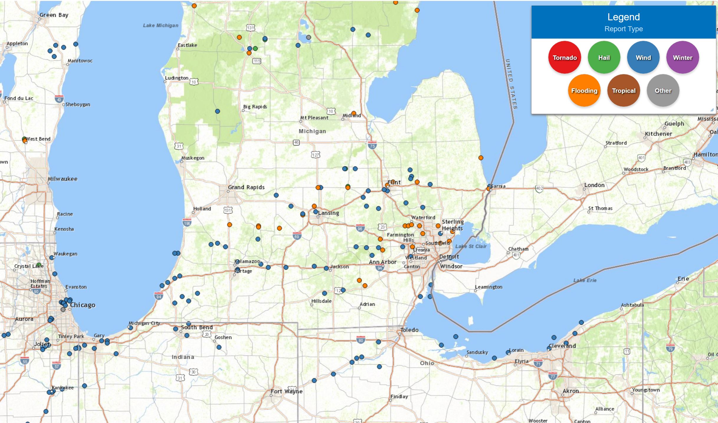
Storm Reports
|
|
Severe Weather Local Storm Reports:
PRELIMINARY LOCAL STORM REPORT...SUMMARY
NATIONAL WEATHER SERVICE DETROIT/PONTIAC MI
837 AM EDT THU AUG 4 2022

..TIME...   ...EVENT...      ...CITY LOCATION...     ...LAT.LON...
..DATE...   ....MAG....      ..COUNTY LOCATION..ST.. ...SOURCE....
            ..REMARKS..

0417 PM     TSTM WND GST     4 SSW FLINT             42.98N 83.73W
08/03/2022  M60.00 MPH       GENESEE            MI   ASOS

            MEASURED AT FLINT BISHOP AIRPORT

0421 PM     TSTM WND DMG     COLUMBIAVILLE           43.16N 83.41W
08/03/2022                   LAPEER             MI   911 CALL CENTER

            REPORT OF MULTIPLE TREES AND POWERLINES DOWN

0422 PM     TSTM WND DMG     BYRON                   42.83N 83.95W
08/03/2022                   SHIAWASSEE         MI   911 CALL CENTER

            REPORT OF MULTIPLE TREES AND POWERLINES DOWN

0425 PM     TSTM WND DMG     5 S COLUMBIAVILLE       43.08N 83.40W
08/03/2022                   LAPEER             MI   PUBLIC

            LARGE HEALTHY TREE DOWN ROUGHLY 18 INCHES IN DIAMETER.
            SENT VIA SOCIAL MEDIA PHOTO.

0425 PM     TSTM WND DMG     4 W FENTON              42.81N 83.80W
08/03/2022                   GENESEE            MI   NWS EMPLOYEE

            REPORT OF A DOWNED TREE

0428 PM     TSTM WND DMG     4 SSE COLUMBIAVILLE     43.10N 83.39W
08/03/2022                   LAPEER             MI   911 CALL CENTER

            REPORT OF MULTIPLE TREES AND POWERLINES DOWN

0439 PM     TSTM WND DMG     ATTICA                  43.03N 83.16W
08/03/2022                   LAPEER             MI   911 CALL CENTER

            REPORT OF MULTIPLE TREES AND POWERLINES DOWN

0445 PM     TSTM WND DMG     1 NW ORTONVILLE         42.86N 83.46W
08/03/2022                   OAKLAND            MI   AMATEUR RADIO

            REPORT OF MULTIPLE TREES DOWN OR SHEARED NEAR
            INTERSECTION OF GROVELAND RD AND M15

0502 PM     TSTM WND DMG     OXFORD                  42.82N 83.25W
08/03/2022                   OAKLAND            MI   TRAINED SPOTTER

            REPORT OF A TREE LIMBS DOWN ESTIMATED 6 TO 8 INCHES
            DIAMETER. PHOTO SENT VIA SOCIAL MEDIA

0512 PM     MARINE TSTM WIND 1 NNE PORT HURON        43.01N 82.42W
08/03/2022  M40.00 MPH       St. Clair          MI   C-MAN STATION

0518 PM     TSTM WND DMG     MANCHESTER              42.15N 84.04W
08/03/2022                   WASHTENAW          MI   PUBLIC

            TREES AND POWERLINES DOWN. PHOTO SEND VIA SOCIAL MEDIA.

0554 PM     TSTM WND DMG     PINCKNEY                42.45N 83.95W
08/03/2022                   LIVINGSTON         MI   PUBLIC

            REPORT OF SEVERAL DOWNED TREES. REPORT SENT VIA SOCIAL
            MEDIA PHOTOS

0605 PM     TSTM WND DMG     1 SW NOVI               42.46N 83.50W
08/03/2022                   OAKLAND            MI   PUBLIC

            MULTIPLE DOWNED TREES. PHOTOS SENT VIA SOCIAL MEDIA

0615 PM     TSTM WND DMG     2 SW LIVONIA            42.37N 83.40W
08/03/2022                   WAYNE              MI   PUBLIC

            MULTIPLE TREES DOWN OR SHEARED. REPORT SENT VIA SOCIAL
            MEDIA PHOTOS

0615 PM     TSTM WND DMG     5 E STOCKBRIDGE         42.46N 84.08W
08/03/2022                   LIVINGSTON         MI   911 CALL CENTER

            REPORTS OF FIVE DOWNED TREES AND SEVERAL DOWNED
            POWERLINES

0618 PM     TSTM WND DMG     3 S BROOKLYN            42.06N 84.24W
08/03/2022                   LENAWEE            MI   PUBLIC

            MULTIPLE TREES DOWN AND BLOWN OVER TENTS AT MICHIGAN
            INTERNATIONAL SPEEDWAY

0618 PM     TSTM WND DMG     STERLING HEIGHTS        42.58N 83.03W
08/03/2022                   MACOMB             MI   PUBLIC

            REPORT OF A DOWNED TREE ROUGHLY 18 INCHES IN DIAMETER.
            PHOTO SENT VIA SOCIAL MEDIA

0626 PM     TSTM WND DMG     4 N DEXTER              42.38N 83.88W
08/03/2022                   WASHTENAW          MI   TRAINED SPOTTER

            MULTIPLE TREE LIMBS AND POWER LINES DOWN ACROSS THE AREA.


0630 PM     MARINE TSTM WIND 2 S GROSSE POINTE       42.36N 82.91W
08/03/2022  M55.00 MPH       LCZ460             MI   PUBLIC

0631 PM     TSTM WND DMG     HAMBURG                 42.45N 83.80W
08/03/2022                   LIVINGSTON         MI   911 CALL CENTER

            REPORT OF MULTIPLE DOWNED TREES AND WIRES

0736 PM     MARINE TSTM WIND 4 ENE ESTRAL BEACH      42.00N 83.16W
08/03/2022  M41.00 MPH       LEZ444             MI   C-MAN STATION

0736 PM     MARINE TSTM WIND 1 S GROSSE ILE          42.11N 83.15W
08/03/2022  E39.00 MPH       Wayne              MI   AWOS

0755 PM     MARINE TSTM WIND 1 E NEWPORT             42.00N 83.28W
08/03/2022  M46.00 MPH       Monroe             MI   PUBLIC

0900 PM     HEAVY RAIN       WIXOM                   43.67N 84.11W
08/03/2022  M2.35 INCH       BAY                MI   TRAINED SPOTTER

            4 HOUR RAINFALL TOTAL

1000 PM     HEAVY RAIN       WARREN                  42.49N 83.03W
08/03/2022  M1.81 INCH       Macomb             MI   TRAINED SPOTTER

            5 HOUR TOTAL.

1200 AM     HEAVY RAIN       PORT HURON              42.99N 82.43W
08/04/2022  M1.86 INCH       ST. CLAIR          MI   CO-OP OBSERVER

            24 HOUR RAINFALL TOTAL.

1200 AM     HEAVY RAIN       MOUNT CLEMENS           42.60N 82.88W
08/04/2022  M1.76 INCH       MACOMB             MI   CO-OP OBSERVER

            24 HOUR RAINFALL TOTAL.

1230 AM     HEAVY RAIN       4 E WHITE LAKE          42.65N 83.43W
08/04/2022  M1.98 INCH       OAKLAND            MI   OFFICIAL NWS OBS

            8 HOUR RAINFALL TOTAL AT THE NWS WHITE LAKE OFFICE.

0651 AM     HEAVY RAIN       LEXINGTON               43.27N 82.53W
08/04/2022  M2.09 INCH       SANILAC            MI   CO-OP OBSERVER

            24 HOUR RAINFALL TOTAL.

0700 AM     HEAVY RAIN       WATERFORD               42.66N 83.39W
08/04/2022  M2.20 INCH       OAKLAND            MI   COCORAHS

            24 HOUR RAINFALL TOTAL.

0700 AM     HEAVY RAIN       1 ENE ROSEVILLE         42.51N 82.92W
08/04/2022  M1.39 INCH       MACOMB             MI   COCORAHS

            24 HOUR RAINFALL TOTAL.

0700 AM     HEAVY RAIN       4 N BURTON              43.05N 83.62W
08/04/2022  M1.54 INCH       GENESEE            MI   CO-OP OBSERVER

            24 HOUR RAINFALL TOTAL.

0700 AM     HEAVY RAIN       OWOSSO                  43.00N 84.18W
08/04/2022  M1.77 INCH       SHIAWASSEE         MI   CO-OP OBSERVER

            24 HOUR RAINFALL TOTAL.

0700 AM     HEAVY RAIN       FLINT                   43.02N 83.69W
08/04/2022  M1.72 INCH       GENESEE            MI   OFFICIAL NWS OBS

            24 HOUR RAINFALL TOTAL.

0700 AM     HEAVY RAIN       BLOOMFIELD HILLS        42.58N 83.25W
08/04/2022  M1.99 INCH       OAKLAND            MI   TRAINED SPOTTER

            24 HOUR RAINFALL.

0700 AM     HEAVY RAIN       2 SW SHELBY TOWNSHIP    42.65N 83.06W
08/04/2022  M1.54 INCH       MACOMB             MI   COCORAHS

            24 HOUR RAINFALL TOTAL.

0700 AM     HEAVY RAIN       WHITMORE LAKE           42.43N 83.75W
08/04/2022  M2.26 INCH       LIVINGSTON         MI   CO-OP OBSERVER

            24 HOUR RAINFALL TOTAL.

0700 AM     HEAVY RAIN       2 N CLINTON             42.10N 83.97W
08/04/2022  M1.60 INCH       WASHTENAW          MI   COCORAHS

            24 HOUR RAINFALL TOTAL.

0730 AM     HEAVY RAIN       LAPEER                  43.05N 83.32W
08/04/2022  M1.34 INCH       LAPEER             MI   CO-OP OBSERVER

            24 HOUR RAINFALL TOTAL.

0730 AM     HEAVY RAIN       FARMINGTON              42.46N 83.38W
08/04/2022  M1.48 INCH       OAKLAND            MI   CO-OP OBSERVER

            24 HOUR RAINFALL TOTAL.

0738 AM     HEAVY RAIN       MANCHESTER              42.15N 84.04W
08/04/2022  M1.04 INCH       WASHTENAW          MI   CO-OP OBSERVER

            24 HOUR RAINFALL TOTAL.

0800 AM     HEAVY RAIN       BRIGHTON                42.53N 83.78W
08/04/2022  M1.30 INCH       LIVINGSTON         MI   CO-OP OBSERVER

            24 HOUR RAINFALL TOTAL.
 |
|
National Storm Reports for August 3, 2022 |
Environment
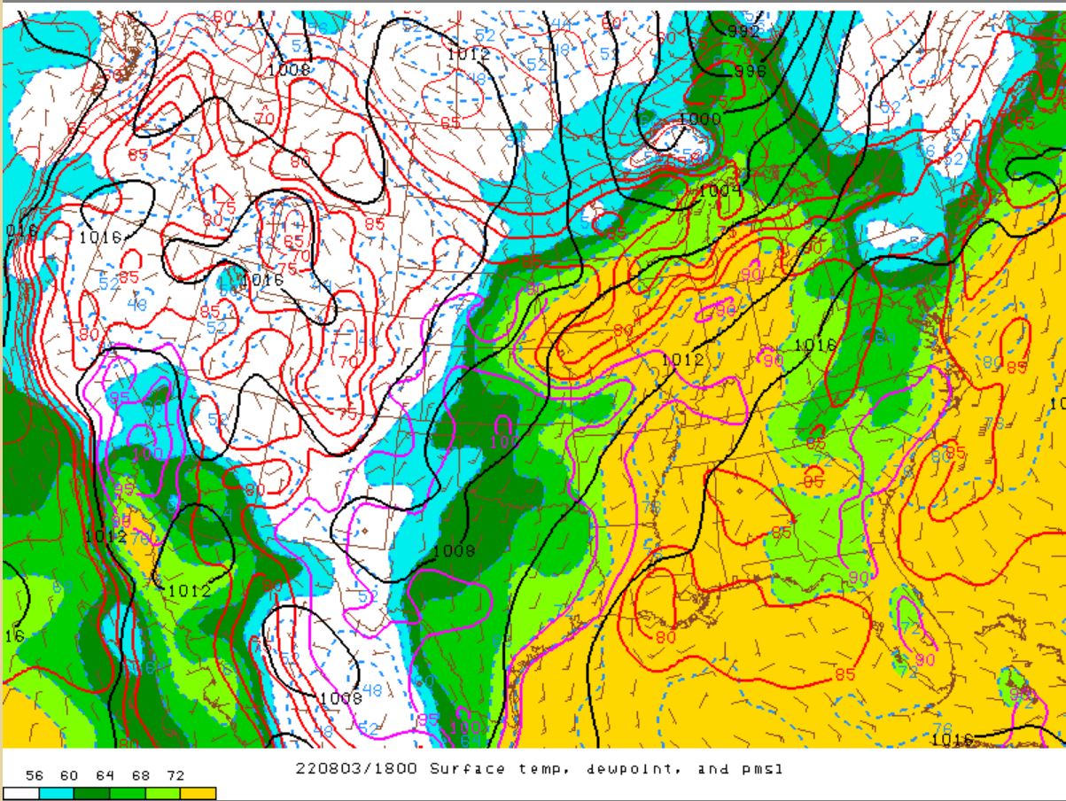
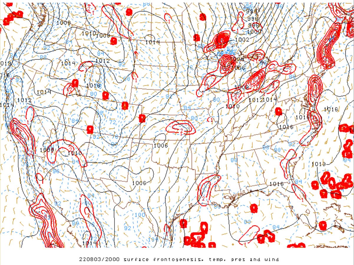
A shortwave trough that was located over the upper Mississippi Valley early Wednesday morning pivoted into the Great Lakes region through the evening, with a surface cold front extending from the James Bay and into SE Minnesota (Figure 1). Very humid conditions pushed into SE MI ahead of the front, with dew points increasing into the low to mid 70s (Figure 6), which allowed moderate to strong instability to build through the afternoon. A special 18Z RAOB sounding at DTX showed a MLCAPE ~ 2,500 J/kg (Figure 3), with values nearing 3,000 J/kg across southern Michigan (Figure 8). Upstream multicellular convection became more organized and turned increasingly linear across the Tri-Cities and northern Thumb, as surface convergence/frontogenesis increased (Figure 10). Thunderstorm activity gradually expanded southward with the modest deep layer shear (Figure 9) and where strong instability existed. Deep moisture convergence with high precipitation water values (Figure 7) with the aforementioned instability aided in the production of intense updrafts, which produced water loaded wind gusts on the order of 55-65 mph under the strongest storms. This was further enhanced by strong low-level lapse rates (Figure 11) and DCAPE values (Figure 12).
Isolated to multicellar convection started to bubble up ahead of this main line across Port Huron and the Metro region along an outflow boundary and from differential heating, with a Mesoscale Convective Vortex (MCV) from southwest Michigan eventually catching up with this line. Mini bowing segments along with continued precipitation loading brought addition strong to severe storms all the way down into the Ohio border, with wind gusts ranging between 55-65 mph. Last, due to the high moisture content, rainfall accumulation totals in excess of 2 inches fell within four hours (Figure 5) and led to localized flooding. This prompted the issuance of several flood advisories across SE MI.
Click on the images below to see them expanded.
 |
 |
 |
| Figure 1: WPC Surface Analysis, valid 2100 UTC 03 August 2022 | Figure 2: SPC Day 1 Outlook, valid 1300 UTC 03 August 2022 | Figure 3: KDTX observed sounding, valid 1800 UTC 03 August 2022 |
|
 |
 |
| Figure 4: SPC Storm Reports, valid 03 August 2022 | Figure 5: Advanced Hydrologic Predictive Services 24 Hr Precipitation Estimates, Valid 12 UTC 03 Aug 2022 | Figure 6: Dew Points, valid 18 UTC 03 Aug 2022 |
 |
 |
 |
| Figure 7: Precipitable Water, valid 18 UTC 03 Aug 2022 | Figure 8: MLCAPE, valid 20 UTC 03 Aug 2022 | Figure 9: Effective Bulk Shear, valid 18 UTC 03 Aug 2022 |
 |
 |
 |
| Figure 10: Surface Frontogensis, valid 20 UTC 03 Aug 2022 | Figure 11: 0-3 km lapse rates, valid 18 UTC 03 Aug 2022 | Figure 12: DCAPE, valid 18 UTC 03 Aug 2022 |
 |
Media use of NWS Web News Stories is encouraged! Please acknowledge the NWS as the source of any news information accessed from this site. |
|