Overview
Event Summary
A significant winter storm impacted Southeast Michigan from the evening of February 15, 2021 into the morning hours of February 16. This President's Day storm was the first Winter Storm Warning issued across Southeast Michigan for the 2020-2021 winter season, and the latest first warning event of the season since at least 2005-2006. The event was preceded by a Winter Weather Advisory that was in effect during the morning of February 15, for a light snow event that brought about 1 to 1.5 inches of snow across much of the region. The synopsis and snowfall reports provided on this page refer only to the second, more impactful round of snowfall that arrived during the evening of the 15th.
The large scale pattern during the middle of February was dominated by an arctic air mass over the Great Plains that placed Southeast Michigan on its eastern periphery. The storm track brought numerous light snow events through the Great Lakes during this period. On February 15, a potent southern stream wave lifted northeast from eastern Texas and into the Ohio Valley by the evening. This system's southern track enabled it to tap into more abundant Gulf moisture than previous systems. The associated surface and 850mb low pressure centers tracked across Ohio, placing Southeast Michigan within the favorable northwest quadrant (featuring the mature system's trowal axis and deformation forcing) during the overnight hours.
The system produced liquid equivalent precipitation amounts of 0.30 to over 0.50 inches and snow-to-liquid ratios ranging from 13:1 to 20:1. The result was heavy snow across most of the region with a widespread 6 to 9 inches outside of the Tri-Cities region. Gusty northeast wind during the event brought enhanced moisture in along the Lake Huron shoreline with locations across St. Clair and southern Sanilac County reporting over a foot of snow. Snowfall rates exceeded 1 inch per hour during the peak of the event, which occurred shortly after midnight. Winds gusted in excess of 30 mph during the morning which led to significant blowing and drifting of snow. Snowfall tapered off from south to north as the dry slot moved in during the mid-morning hours.
Note: Given the dry to fluffy nature of the snowfall and northerly gusts to 30 mph that occurred during the duration of the snowfall, drifting and blowing snow was observed after the snow initially settled. This resulted in highly variable snowfall totals over a small distance.
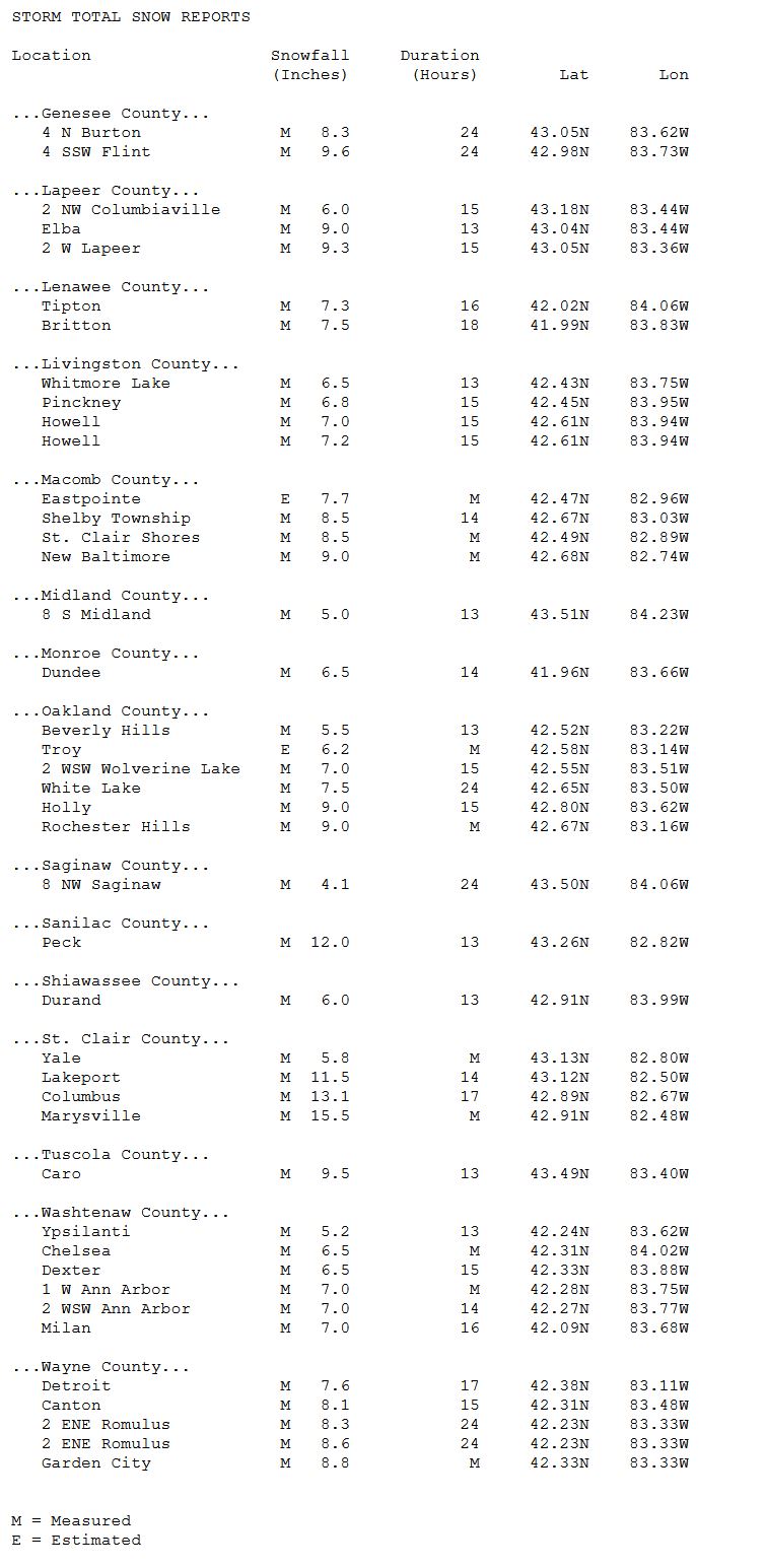
Snowfall Totals
For more detailed snow reports, please see the storm reports tab.

Radar
 |
 |
 |
|
Radar Loop of Snow Event from 4 PM to 10 PM 2/15/21 |
Radar Loop of Snow Event from 10 PM 2/15/21 to 4 AM 2/16/21 |
Radar Loop of Snow Event from 4 AM to 10 AM 2/16/21 |
 |
Media use of NWS Web News Stories is encouraged! Please acknowledge the NWS as the source of any news information accessed from this site. |
|