Overview
A significant winter storm impacted southeast Michigan on the afternoon and evening of Friday, March 3, 2023. A compact but very strong low pressure system tracked up the Ohio Valley, bringing strong lift and abundant moisture to the region. Despite air temperatures hovering near or slightly above freezing in many areas, the heavy snowfall rates allowed for rapid accumulations during rush hour and into the evening. Snowfall rates became so intense (2-3 inches per hour in some locations) that numerous bouts of thundersnow were observed in the evening. The heavy, wet snow exhibited snow to liquid ratios below 10:1 and piled up quickly on trees and power lines that were already stressed from recent winter storms on February 22nd and February 27th. This, combined with gusty winds, resulted in over 200,000 customers losing power across the area. The strong winds also resulted in lakeshore flooding along the Lake Erie shoreline.
Widespread snow totals of 8 to 11 inches occurred along a corridor from Jackson to Howell and Ann Arbor, the northern Metro Detroit suburbs, Lapeer, and parts of St. Clair and Sanilac Counties. A sharp snowfall gradient occurred to the north over the Tri-Cities and Thumb which saw totals generally ranging from 1 to 5 inches. To the south, milder air allowed for some rain to mix in at times across Monroe, southern Wayne, and parts of Lenawee Counties which reduced snowfall totals in those locations. Daily snowfall records for March 3rd were broken/tied at all three climate sites: Detroit - 6.2" (previous: 6.0" from 1875); Flint - 4.9" (previous 4.9" from 1954); Saginaw - 2.5" (previous: 2.3" from 2015).
Snow Totals
Public Information Statement
National Weather Service Detroit/Pontiac MI
1023 AM EST Sat Mar 4 2023

...SNOWFALL REPORTS...

Location                     Amount    Time/Date       Lat/Lon

...Michigan...

...Bay County...
3.3 E Auburn                 1.8 in    0630 AM 03/04   43.63N/84.02W
Bay City                     1.4 in    0243 AM 03/04   43.59N/83.89W

...Genesee County...
Goodrich                     9.4 in    0730 AM 03/04   42.92N/83.51W
3.4 SE Genesee               8.3 in    0700 AM 03/04   43.07N/83.59W
Linden                       7.6 in    0657 AM 03/04   42.82N/83.78W
Grand Blanc                  7.5 in    0741 AM 03/04   42.93N/83.62W
Davison                      6.7 in    0730 AM 03/04   43.03N/83.52W
Linden                       6.0 in    0700 AM 03/04   42.81N/83.80W
Flint                        5.0 in    0104 AM 03/04   43.02N/83.69W

...Huron County...
Bad Axe                      5.0 in    0735 AM 03/04   43.82N/83.00W
1.3 E Port Austin            1.0 in    0800 AM 03/04   44.05N/82.97W

...Lapeer County...
Lapeer                       10.0 in   0632 AM 03/04   43.05N/83.32W
North Branch                 9.5 in    0855 AM 03/04   43.23N/83.19W
5 W Lapeer                   9.0 in    0555 AM 03/04   43.05N/83.42W
1.3 W Lapeer                 7.0 in    0730 AM 03/04   43.05N/83.35W

...Lenawee County...
Clinton 0.5 NE               7.8 in    0700 AM 03/04   42.08N/83.97W
Tecumseh                     6.0 in    0720 AM 03/04   42.01N/83.94W
Morenci                      2.6 in    0730 AM 03/04   41.72N/84.20W

...Livingston County...
Howell                       10.0 in   1159 PM 03/03   42.61N/83.94W
Tyrone Township              10.0 in   0822 AM 03/04   42.73N/83.75W
Howell                       9.6 in    0747 AM 03/04   42.61N/83.94W

...Macomb County...
1.8 SW Memphis               8.7 in    0800 AM 03/04   42.88N/82.80W
3 N Utica                    7.4 in    0557 AM 03/04   42.67N/83.03W
4 SSW New Haven              6.0 in    0852 AM 03/04   42.68N/82.82W
Macomb Township              5.5 in    0809 AM 03/04   42.67N/82.92W
4 SSW New Haven              5.0 in    1235 AM 03/04   42.68N/82.82W
2 SSE Fraser                 4.5 in    0724 AM 03/04   42.51N/82.94W
4 ESE Warren                 4.3 in    0212 AM 03/04   42.47N/82.96W
1 NNW Saint Clair Shores     4.1 in    0500 AM 03/04   42.51N/82.90W
Roseville 1.7 ENE            4.1 in    0500 AM 03/04   42.51N/82.90W

...Midland County...
0.8 SE Midland               2.0 in    0700 AM 03/04   43.62N/84.22W
Midland 4.4 SW               1.5 in    0600 AM 03/04   43.57N/84.28W
Midland                      1.2 in    1235 AM 03/04   43.62N/84.23W
3.0 E Oil City               1.1 in    0730 AM 03/04   43.61N/84.53W

...Oakland County...
2 WSW Rochester              10.5 in   1159 PM 03/03   42.67N/83.16W
Highland                     10.5 in   1235 AM 03/04   42.64N/83.62W
4 NNE Davisburg              10.5 in   0748 AM 03/04   42.81N/83.52W
3 E Milford                  10.3 in   0615 AM 03/04   42.59N/83.54W
5 S White Lake               10.1 in   0243 AM 03/04   42.59N/83.49W
Pontiac                      10.0 in   0753 AM 03/04   42.65N/83.29W
1 NE Waterford               9.6 in    0700 AM 03/04   42.68N/83.37W
2 WSW Waterford              9.3 in    0700 AM 03/04   42.65N/83.43W
Oxford                       9.0 in    0829 AM 03/04   42.82N/83.25W
2 SW Novi                    9.0 in    0905 AM 03/04   42.46N/83.52W
Leonard                      8.8 in    0836 AM 03/04   42.87N/83.14W
Wixom 2.0 NNW                8.7 in    0800 AM 03/04   42.55N/83.55W
Ortonville 2.3 S             8.2 in    0700 AM 03/04   42.82N/83.44W
5 WSW Orchard Lake           8.0 in    0243 AM 03/04   42.56N/83.47W
4 WSW Davisburg              8.0 in    0525 AM 03/04   42.73N/83.62W
Waterford 2.1 NW             8.0 in    0630 AM 03/04   42.69N/83.41W
2 ESE Clarkston              8.0 in    0731 AM 03/04   42.72N/83.38W
Ortonville                   8.0 in    0817 AM 03/04   42.85N/83.44W
Northville                   7.5 in    0758 AM 03/04   42.44N/83.49W
1 S Clarkston                7.5 in    0820 AM 03/04   42.72N/83.42W
2 N Farmington               7.0 in    1159 PM 03/03   42.49N/83.38W
Troy                         6.0 in    0630 AM 03/04   42.58N/83.14W
Bloomfield Township 3.1 SW   6.0 in    0700 AM 03/04   42.55N/83.32W
Bloomfield Hills             6.0 in    0735 AM 03/04   42.58N/83.25W
2 ESE Royal Oak              5.8 in    0734 AM 03/04   42.50N/83.11W
2 S Birmingham               5.0 in    1159 PM 03/03   42.52N/83.22W
0.6 E Farmington             5.0 in    0730 AM 03/04   42.47N/83.37W
3 ESE Royal Oak              4.5 in    0716 AM 03/04   42.50N/83.10W
2 SSW Royal Oak              4.0 in    0212 AM 03/04   42.48N/83.17W

...Saginaw County...
Saginaw                      2.5 in    0104 AM 03/04   43.42N/83.95W
3 NW Oakley                  2.5 in    0718 AM 03/04   43.17N/84.21W
0.6 SW Saginaw               2.3 in    0800 AM 03/04   43.41N/83.96W
2.4 NE Chesaning             2.0 in    0730 AM 03/04   43.22N/84.10W
Birch Run                    2.0 in    0922 AM 03/04   43.25N/83.79W

...Sanilac County...
Deckerville                  5.0 in    1100 AM 03/04   43.52N/82.74W

...Shiawassee County...
1.0 N Durand                 5.5 in    0800 AM 03/04   42.93N/83.99W
Durand 6.2 WNW               5.2 in    0800 AM 03/04   42.93N/84.10W
2.3 SW Owosso                4.7 in    0700 AM 03/04   42.97N/84.20W

...St. Clair County...
Marysville                   6.3 in    0243 AM 03/04   42.91N/82.48W
4 ENE Ruby                   6.0 in    0924 AM 03/04   43.06N/82.53W
4 WSW Smiths Creek           5.8 in    0645 AM 03/04   42.89N/82.67W
Port Huron 2.8 WSW           5.5 in    0700 AM 03/04   42.98N/82.49W
Port Huron                   5.3 in    0715 AM 03/04   42.99N/82.43W
2 NE Ruby                    4.5 in    0243 AM 03/04   43.07N/82.58W

...Tuscola County...
Caro                         4.3 in    0700 AM 03/04   43.45N/83.40W
Vassar                       3.4 in    0700 AM 03/04   43.37N/83.58W

...Washtenaw County...
Ann Arbor                    9.0 in    1235 AM 03/04   42.28N/83.73W
Ann Arbor Se                 8.4 in    0730 AM 03/04   42.24N/83.69W
Ann Arbor                    8.2 in    0700 AM 03/04   42.28N/83.73W
Chelsea 3.7 NNE              8.0 in    0800 AM 03/04   42.36N/83.99W
Ypsilanti                    7.8 in    0243 AM 03/04   42.24N/83.62W
Dexter                       7.3 in    0801 AM 03/04   42.33N/83.88W
Saline                       7.0 in    0802 AM 03/04   42.18N/83.78W
Chelsea                      7.0 in    0809 AM 03/04   42.31N/84.02W
Manchester                   6.5 in    0906 AM 03/04   42.15N/84.04W

...Wayne County...
3 ENE Westland               6.6 in    0243 AM 03/04   42.33N/83.33W
Romulus                      6.2 in    0104 AM 03/04   42.22N/83.37W
3 SSE Lincoln Park           5.5 in    1235 AM 03/04   42.21N/83.16W
1 NE Grosse Pointe           4.0 in    0800 AM 03/04   42.40N/82.89W
Livonia 2.3 NNW              3.5 in    0740 AM 03/04   42.43N/83.38W
1.1 W Dearborn               3.2 in    0900 AM 03/04   42.32N/83.23W
Livonia 2.0 NE               3.0 in    0700 AM 03/04   42.42N/83.34W

Observations are collected from a variety of sources with varying
equipment and exposures. We thank all volunteer weather observers
for their dedication. Not all data listed are considered official.

$$
 |
|
Storm Total Snowfall |
Wind Reports
Public Information Statement
National Weather Service Detroit/Pontiac MI
704 AM EST Sat Mar 4 2023

...HIGHEST WIND REPORTS OVER THE PAST 24 HOURS...

Location                     Speed     Time/Date       Lat/Lon
Detroit River Light          54 MPH    0541 PM 03/03   42.00N/83.14W
Peche Island Light           52 MPH    0601 PM 03/03   42.36N/82.91W
Grosse Pointe YC             48 MPH    0547 PM 03/03   42.43N/82.87W
Fort Gratiot, MI             47 MPH    0200 AM 03/04   43.01N/82.42W
Adrian                       45 MPH    0457 PM 03/03   41.87N/84.08W
Detroit City Air             45 MPH    0646 PM 03/03   42.40N/83.02W
Port Huron                   45 MPH    0815 PM 03/03   42.92N/82.52W
Detroit Wayne                44 MPH    0639 PM 03/03   42.23N/83.33W
Detroit Willow               44 MPH    0537 PM 03/03   42.23N/83.53W
Lexington Harbor             44 MPH    1152 PM 03/03   43.27N/82.52W
Ann Arbor                    41 MPH    0540 PM 03/03   42.22N/83.73W
1 N Grosse Pointe Shore      40 MPH    0600 PM 03/03   42.47N/82.88W
Harbor Beach, MI             40 MPH    1130 PM 03/03   43.85N/82.64W
Flint                        40 MPH    0552 PM 03/03   42.97N/83.75W
Pontiac                      40 MPH    0544 PM 03/03   42.67N/83.42W
Caseville Light              40 MPH    0150 AM 03/04   43.95N/83.29W

Observations are collected from a variety of sources with varying
equipment and exposures. We thank all volunteer weather observers
for their dedication. Not all data listed are considered official.

$$
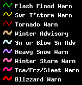
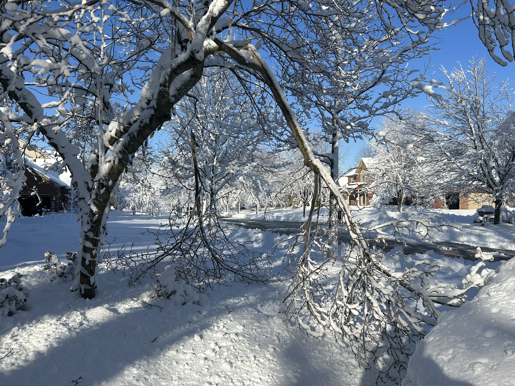
Photos
 |
 |
 |
|
Novi Credit: Nick Dewhirst |
Novi Credit: Nick Dewhirst |
Rochester Hills Credit: @MiWxAnthony |
Radar
|
|
|
Radar: NEXRAD mosaic base reflectivity radar loop from 1240 PM Mar 3, 2023 through 1 AM Mar 4, 2023.
|
Environment
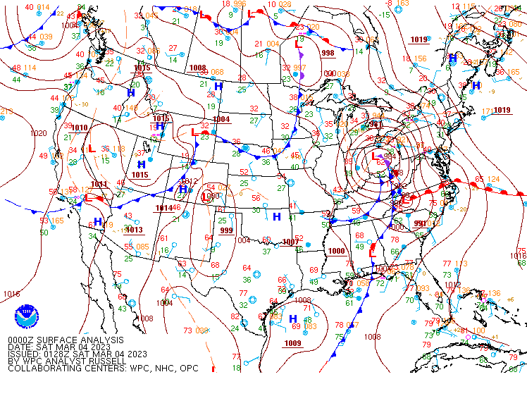
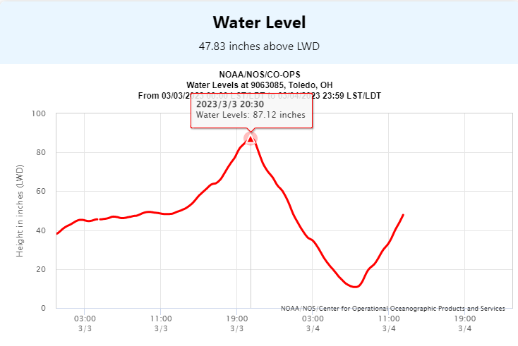
A strong low ejected northeast out of the central Mississippi River Valley during the afternoon of March 3rd. Although the low began to weaken, the center of low tracked through northwest Ohio at 984 MB during the evening (Figure 1). With retreating high pressure over eastern Canada, northeast winds of 35-45 mph were common across much of southeast Michigan, with locally higher gusts in convective activity (see Wind Reports tab). The prolonged easterly winds over Lake Erie led to lakeshore flooding and lakeshore erosion. The Lake Erie water level measured at Toledo reached 87.12 inches above the low water datum at 8:30 PM EST (Figure 2).
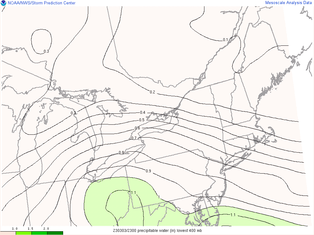
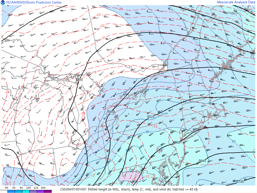
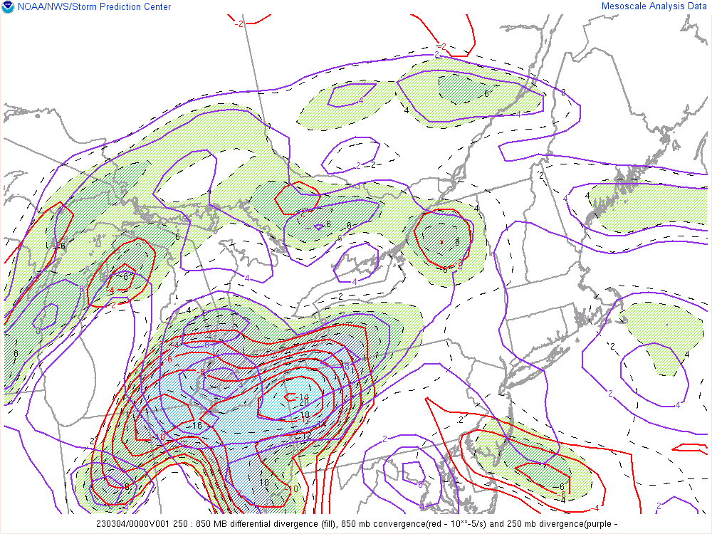
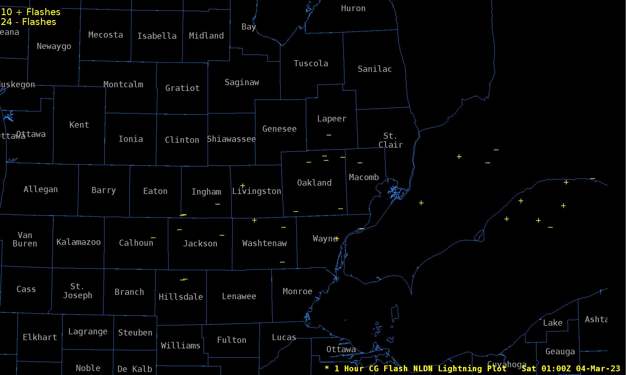
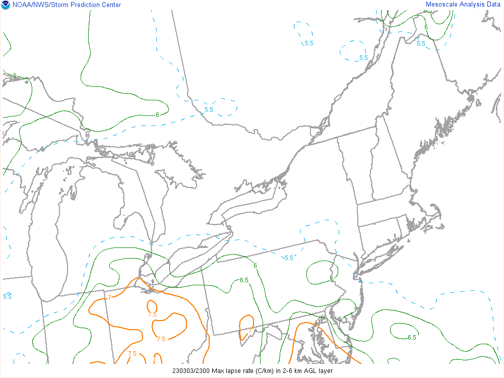
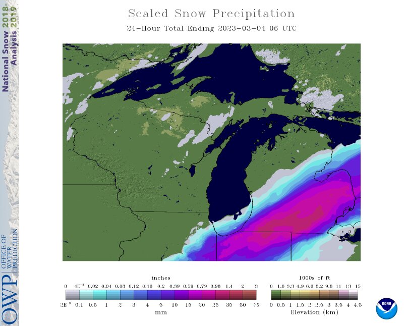
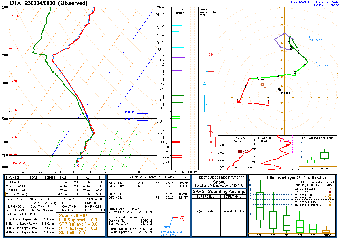
A good deal of moisture surged northward ahead of the low, with precipitable water values of 1 inch nearing the southern Michigan border (Figure 3). The strength of the system and negative tilted upper level trough (500 MB) (Figure 4) led to tremendous amount of upper level divergence and corresponding lift over much of southeast Michigan (Figure 5). This produced intense precipitation rates and even scattered to numerous thunderstorms (Figure 6) as lapse rates steepened up just enough in the 2-6 KM layer between 22-02Z (Figure 7). Snowfall rates peaked at 2-3”/hr in spots with the thundersnow, with total liquid equivalent precipitation ending up 0.80” to 1.65” along and south of M-59 (Figure 8), with just about all measurable precipitation occurring in an 8 hr window. Much weaker lift and less available moisture caused snowfall to quickly taper off north of I-69. Just enough of a deeper warm layer penetrated Monroe County and into southern Wayne to support a period of rain and significantly lower snowfall totals. This milder air hovering around freezing in the low-mid levels (Figure 9) also produced the heavy/wet snow farther north with snow to liquid ratios coming in under 10:1.
 |
 |
 |
|
Figure 1: WPC Surface Analysis Valid Mar 4 2023 00UTC |
Figure 2: NOS/CO-OPS Water Level Chart at Toledo |
Figure 3: SPC Mesoanalysis Precipitable Water Valid Mar 3 2023 23UTC |
 |
 |
 |
|
Figure 4: SPC Mesoanalysis 500mb Map Valid Mar 4 2023 01UTC |
Figure 5: SPC Mesoanalysis 250-850mb Diff Divergence Valid Mar 4 2023 01UTC |
Figure 6: NLDN 1 Hour Cloud-to-Ground Lightning Plot Valid Mar 4 2023 01UTC |
 |
 |
 |
|
Figure 7: SPC Mesoanalysis 2-6km Max Lapse Rate Valid Mar 3 2023 23UTC |
Figure 8: NOHRSC 24 Hour Scaled Snow Precipitation (Liquid Equivalent) Valid Mar 4 2023 06UTC |
Figure 9: DTX Upper Air Sounding Valid Mar 4 2023 00UTC |
 |
Media use of NWS Web News Stories is encouraged! Please acknowledge the NWS as the source of any news information accessed from this site. |
|