Overview
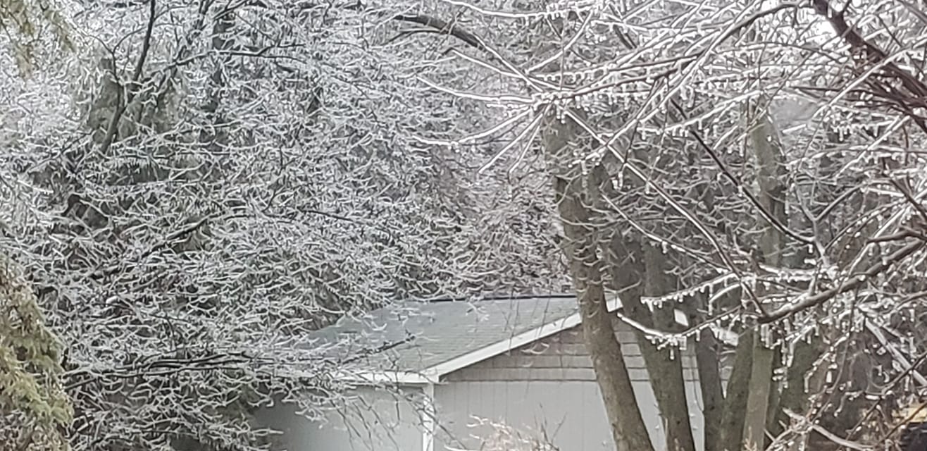
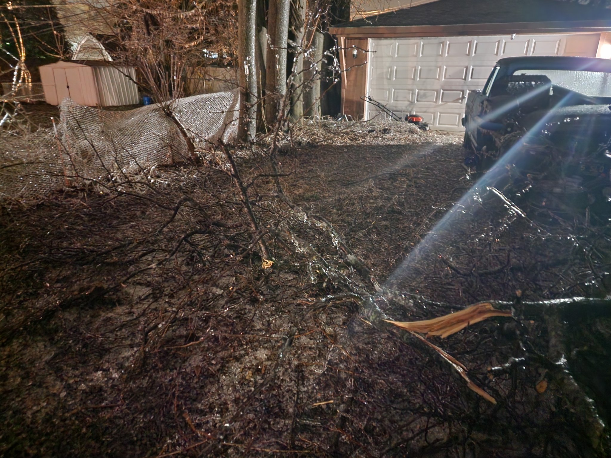
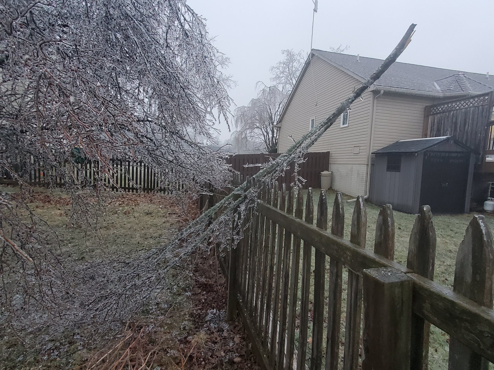
A major winter storm impacted Southeast Michigan during the daytime and evening hours of February 22, 2023. Warm/moist air originating in the Gulf of America surged north toward a surface warm front, increasing coverage and intensity of precipitation over lower Michigan by mid-morning. This warmer air aloft interacted with a resident cold airmass near the surface, creating conditions favorable for snow to the north and a wintry mix for much of the metro Detroit region. The higher snow accumulations occurred across areas north of I-69, with Midland receiving a report of 8.9 inches for the storm total. Communities south of I-69 saw a wintry mix of snow, sleet, and freezing rain which resulted in widespread ice accumulations of a quarter to half inch. The impacts from icing were widespread, with DTE reporting nearly 3,000 downed wires and close to 500,000 customers without power. Similarly, numerous reports of downed tree limbs were reported making some roads impassable. For many metro Detroit communities, an ice storm with this widespread of a footprint has not been observed since April 2003.
Ice & Snow Totals
STORM TOTAL FREEZING RAIN REPORTS

LOCATION                   PRECIP      DURATION
                          (INCHES)      (HOURS)        LAT       LON
...GENESEE COUNTY...
   4 N RANKIN              M  0.14            M     42.97N    83.75W

...LENAWEE COUNTY...
   BRITTON                 M  0.40           10     41.99N    83.83W

...LIVINGSTON COUNTY...
   HOWELL                  M  0.20           10     42.61N    83.94W

...MACOMB COUNTY...
   STERLING HEIGHTS        M  0.13           21     42.58N    83.03W
   EASTPOINTE              M  0.25            M     42.47N    82.96W
   2 WNW ST. CLAIR SHORES  M  0.30           12     42.51N    82.93W
   SHELBY TOWNSHIP         M  0.30            M     42.67N    83.03W

...MONROE COUNTY...
   MONROE                  M  0.31           21     41.92N    83.39W

...OAKLAND COUNTY...
   LEONARD                 E  0.13           21     42.87N    83.14W
   4 E WHITE LAKE          M  0.19           21     42.65N    83.43W
   FARMINGTON HILLS        M  0.20           21     42.49N    83.38W
   PONTIAC                 M  0.20           21     42.65N    83.29W
   2 WSW WOLVERINE LAKE    M  0.30           21     42.55N    83.51W

...WASHTENAW COUNTY...
   ANN ARBOR               M  0.30            M     42.28N    83.73W
   NNW PLEASANT LAKE       M  0.38           12     42.21N    83.95W
   4 NE SALINE             M  0.64            M     42.22N    83.73W
   ANN ARBOR               M  0.65            M     42.28N    83.73W

...WAYNE COUNTY...
   BELLEVILLE              M  0.19            M     42.20N    83.48W
   GARDEN CITY             M  0.31           18     42.33N    83.33W
   2 ENE ROMULUS           M  0.42            M     42.23N    83.33W
   2 SSE NORTHEAST DETROIT M  0.44            M     42.40N    83.02W
   3 NW BELLEVILLE         M  0.58            M     42.23N    83.53W

STORM TOTAL SNOW REPORTS

LOCATION                  SNOWFALL     DURATION
                          (INCHES)      (HOURS)        LAT       LON

...BAY COUNTY...
   2 E BAY CITY            M   6.2           24     43.59N    83.85W
   3 NW BAY CITY           M   6.6           21     43.62N    83.92W
   5 N BAY CITY            M   8.5            M     43.65N    83.89W

...GENESEE COUNTY...
   GOODRICH                M   1.6            M     42.92N    83.51W
   3 SSE GENESEE           M   1.9            M     43.07N    83.59W
   3 NNW DAVISON           M   2.5            M     43.08N    83.55W
   5 SW FLINT              M   2.6           24     42.97N    83.76W
   4 S OTISVILLE           M   3.5            M     43.11N    83.51W

...HURON COUNTY...
   1 N BAD AXE             M   5.2            M     43.82N    83.00W
   1 SE PINNEBOG           M   6.6            M     43.93N    83.09W
   1 SSE HARBOR BEACH      M   7.0           24     42.83N    82.64W
   1 ENE PORT AUSTIN       M   8.0            M     44.05N    82.97W

...LAPEER COUNTY...
   1 W LAPEER              M   2.0            M     43.05N    83.35W
   5 ENE DAVISON           M   2.5           21     43.05N    83.42W
   2 W LAPEER              M   4.3           24     43.06N    83.36W

...MIDLAND COUNTY...
   2 S OIL CITY            M   6.9           24     43.58N    84.59W
   3 NNW POSEYVILLE        M   7.0            M     43.57N    84.28W
   MIDLAND                 M   7.3           23     43.62N    84.23W
   4 SW MIDLAND            M   7.6           21     43.58N    84.29W
   2 E MIDLAND             M   8.0           24     43.62N    84.19W

...SAGINAW COUNTY...
   2 NNE CHESANING         M   1.5            M     43.22N    84.10W
   1 ESE FRANKENMUTH       M   1.8            M     43.32N    83.72W
   OAKLEY                  M   2.0           24     43.14N    84.17W
   4 W SHIELDS             M   5.0           12     43.42N    84.15W

...SANILAC COUNTY...
   LEXINGTON               M   3.4            M     43.26N    82.53W

...SHIAWASSEE COUNTY...
   1 N DURAND              M   1.0            M     42.93N    83.99W
   4 S CORUNNA             M   1.5            M     42.93N    84.10W
   2 SSW OWOSSO            M   2.0            M     42.97N    84.20W

...TUSCOLA COUNTY...
   VASSAR                  M   2.2            M     43.37N    83.58W
   3 S CARO                M   3.0            M     43.45N    83.40W
   1 SSW CASS CITY         M   7.0           24     42.59N    83.18W


M = MEASURED
E = ESTIMATED

$$
 |
 |
|
Storm Total Ice |
Storm Total Snow |
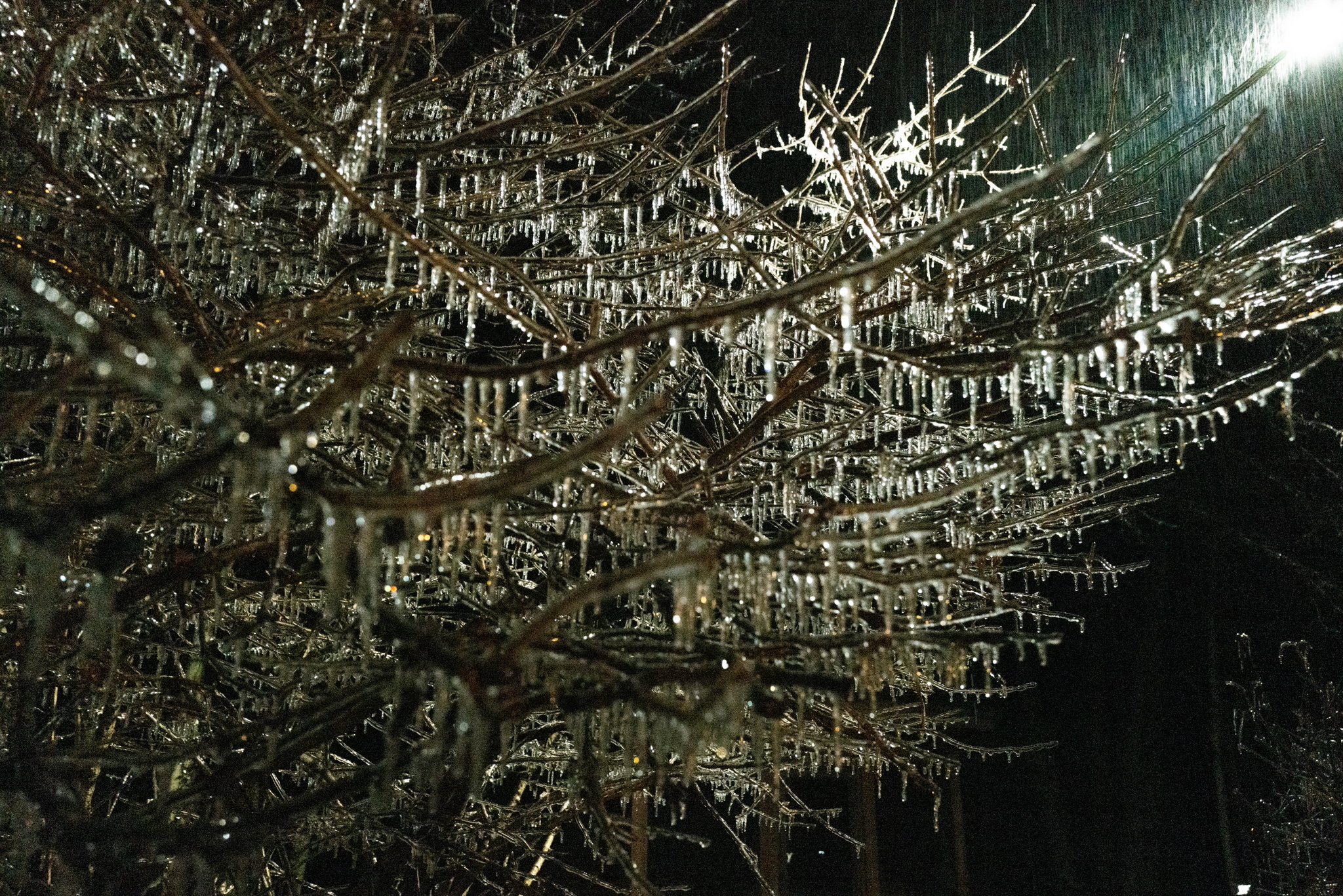
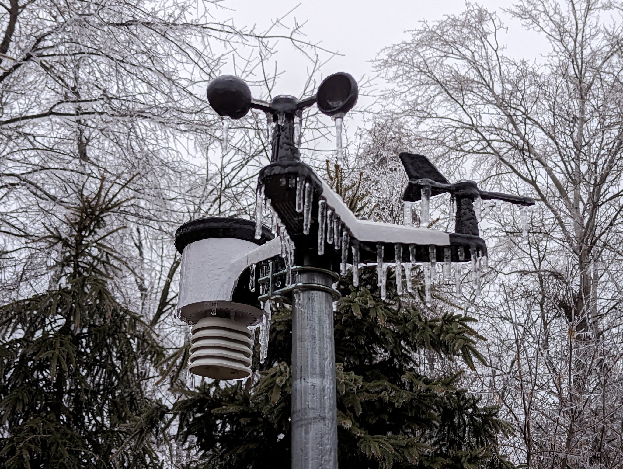
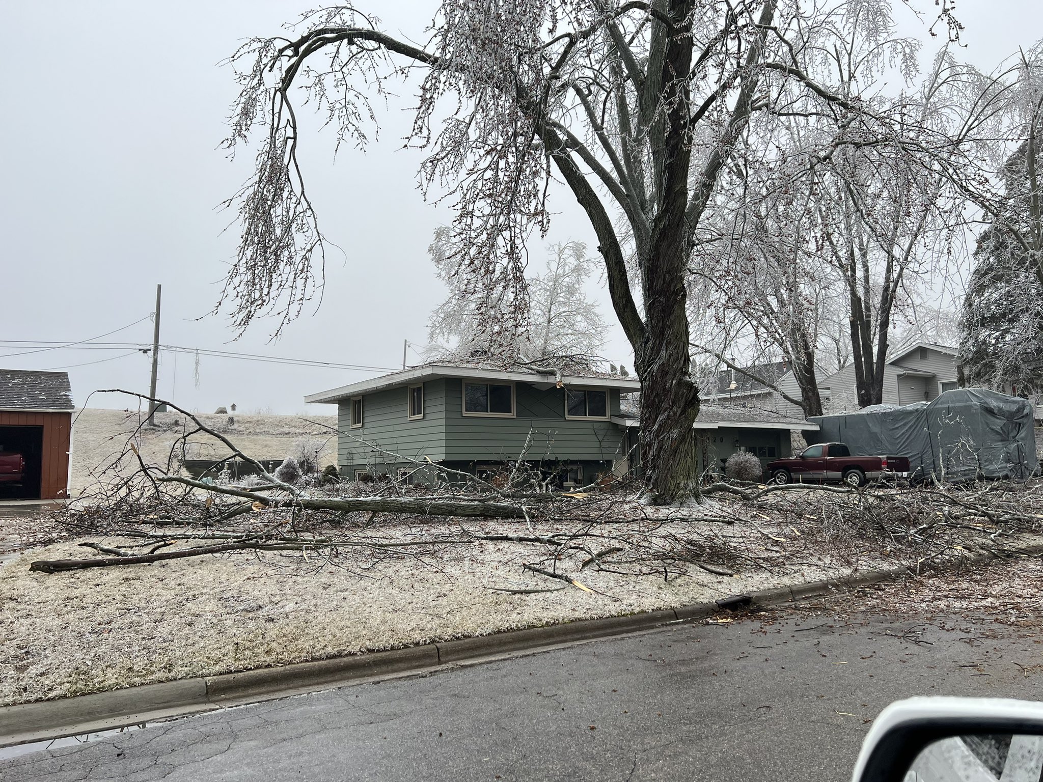
Photos
 |
 |
 |
|
Ann Arbor Credit: Nick Dewhirst |
Ann Arbor Credit: Nick Dewhirst |
Ann Arbor Credit: Nick Dewhirst |
 |
 |
 |
|
Ann Arbor Credit: Daniel Ayala |
Ann Arbor Credit: Patrick Britt |
West of Ann Arbor Credit: Frank Marsik |
 |
 |
 |
|
West of Ann Arbor Credit: Frank Marsik |
West of Ann Arbor Credit: Frank Marsik |
Britton Credit: @RyanWx_ |
 |
 |
 |
|
Britton Credit: @RyanWx_ |
Clinton Credit: @RyanWx_ |
Clinton Credit: @RyanWx_ |
 |
 |
 |
|
Clinton Credit: @RyanWx_ |
Clinton Credit: @RyanWx_ |
Garden City Credit: Thomas Iwinski |
 |
 |
 |
|
Garden City Credit: Thomas Iwinski |
Ida Credit: @3Bryceholmes3 |
Ida Credit: @3Bryceholmes3 |
 |
 |
 |
|
Ida Credit: @3Bryceholmes3 |
Midland Credit: Aaron Joseph |
Monroe Credit: @redtn44 |
 |
 |
 |
|
New Boston Credit: Carolyn Czako |
Rochester Hills Credit: @MiWxAnthony |
Romulus Credit: Nick Toomey |
 |
 |
 |
|
Romulus Credit: Nick Toomey |
Saline Credit: Jeffrey Pitt |
Tecumseh Credit: @RyanWx_ |
 |
 |
 |
|
White Lake Credit: NWS Detroit |
Wyandotte Credit: Josh Halasy |
Ypsilanti Township Credit: Tammy Jex Mayrend |
Radar
|
|
|
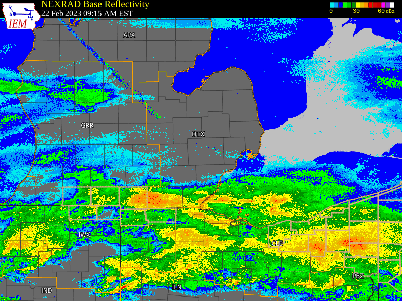
Radar: NEXRAD mosaic base reflectivity radar loop from 9 AM Feb 22, 2023 through 12 AM Feb 23, 2023.
|
Environment
Precipitation initially began to organize over the Ohio Valley during the early morning hours as substantial warm advection served as both the primary forcing mechanism and moisture source for this event. Very light intensity precipitation moved into lower Michigan by daybreak, although largely remained virga in the wake of drier low levels, quantified per the 22.12z KDTX upper air sounding where the observed surface dewpoint depression was +8 degrees F (Figure 1). Nonetheless, some ASOS sites did report mixed precipitation including snow, rain, sleet, and freezing rain during this timeframe. Rapid organization of the precipitation shield occurred through mid-morning, eventually overspreading the cwa by early afternoon and persisting through late that evening. Precipitation type was largely determined by the positioning of the surface warm front and accompanying elevated frontal slope that extended northward into lower Michigan (Figure 2). This elevated frontal slope can be seen quite clearly at the 850 MB pressure level via the tight isotherm gradient over southern lower Michigan (Figure 3). For areas along and south of I-69 where the wintry mix was predominant, the thermal profile was characterized by roughly equivalent warm and cold layers, with the underlying cold layer likely shrinking farther south. The warm nose peaked at 5.4 C at 1.5 kft (836 MB) with a depth of roughly 1.2 kft (850 MB to 733 MB) per the 23.00z KDTX sounding (Figure 4). The resultant melted/supercooled liquid drops then fell through the remaining sub-freezing cold layer (located between the surface and 850 MB, roughly 1.2 kt depth) either refreezing as sleet or hitting sub-freezing surfaces as liquid droplets (freezing rain).
South of the NWS DTX office (northern suburbs and metro Detroit region), the sub-freezing "cold layer" became shallower with closer proximity to the surface warm front which stalled over the Ohio Valley. This increased the number of droplets that were able to reach the ground as liquid, which subsequently froze and accumulated on sub-freezing surfaces (untreated roadways, power lines, trees, etc.) as freezing rain. North of DTX (Tri Cities/Thumb/Flint regions), the aforementioned "warm nose" shifted below freezing which allowed much of the precipitation to either fall as all snow or partially melted ice pellets (sleet). The snow accumulation map depicts a sharp snowfall gradient extending from Saginaw to Caro to Harbor Beach, with the lower snowfall totals representing locations where sleet mixed in with the snow. This is why snowfall totals varied so widely from north to south across Saginaw/Tuscola/Sanilac County (see Ice and Snow Totals → Storm Total Snow graphic).
The system brought precipitation rates that were heavy at times, mainly during the peak which occurred during the late afternoon to mid evening hours. Lapse rates in the lowest 6 km briefly reached 7 C/km (Figure 5) across the MI/OH border region, where about a dozen lightning strikes were reported while freezing rain was ongoing. These convective elements were enveloped in a corridor of stronger mesoscale ascent as a region of strong 850-700mb frontogenesis (Figure 6) pivoted overhead. These factors resulted in high precip rates that, with the loss of daylight, led to rapid accumulation of ice on trees and power lines during the evening.
Overall impacts from this system were quite significant, especially areas south of I-69 where ice accumulation reports were comfortably within the quarter to half inch range. Numerous reports of downed tree branches, nearly 3,000 downed wires (per DTE Energy), and over 500,000 power outages put this storm on par with other 21st century Southeast Michigan ice storms, including December 2013 and April 2003. Farther north, accumulating snowfall led to snow covered roadways and disruptions to travel throughout the entire afternoon and evening.
 |
 |
|
Figure 1: DTX Sounding Valid Feb 22 2023 12UTC |
Figure 2: WPC Surface Analysis Valid Feb 22 2023 18UTC |
 |
 |
|
Figure 3: SPC 850mb Analysis Valid Feb 22 2023 21UTC |
Figure 4: DTX Sounding Valid Feb 23 2023 00UTC |
 |
 |
|
Figure 5: SPC Max Lapse Rate Analysis Valid Feb 23 2023 00UTC |
Figure 6: SPC 850-700mb Fgen Valid Feb 22 2023 23UTC |
 |
Media use of NWS Web News Stories is encouraged! Please acknowledge the NWS as the source of any news information accessed from this site. |
|