Overview
Weakened thunderstorms traversed Lake Michigan during the afternoon hours on June 11, 2022, and largely dissipated upon arrival to Southeast Michigan. A second round of convection worked through late that evening ahead of an advancing cold front as a more unstable environment developed ahead of an advancing cold front. Severe thunderstorm warnings were issued between I-69 and M-59 from 10:41 PM until 1 AM as the strongest lead storm progressed eastward. The storm produced an EF-0 tornado that touched down near the eastern shores of Lake Fenton before lifting 3 miles ESE of Holly, just west of I-75. Several homes, outbuildings, and trees sustained varying degrees of damage. Damaging severe thunderstorm wind gusts redeveloped as the storm crossed through Lapeer causing additional tree and utility line damage.
Tornadoes:
|
Tornado - Lake Fenton to Holly, MI
Track Map

|
||||||||||||||||
The Enhanced Fujita (EF) Scale classifies tornadoes into the following categories:
| EF0 Weak 65-85 mph |
EF1 Moderate 86-110 mph |
EF2 Significant 111-135 mph |
EF3 Severe 136-165 mph |
EF4 Extreme 166-200 mph |
EF5 Catastrophic 200+ mph |
 |
|||||
Photos & Video
Mainly Minor Damage |
 |
 |
 |
| House near Lake Fenton | Tree damage behind house on Addis Rd | Vinyl siding panels | Metal roofing |
Radar
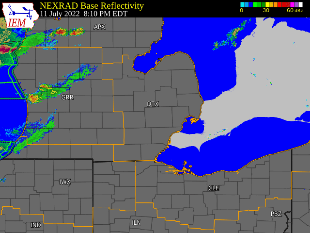 |
 |
 |
 |
| Radar Loop | Four Panel Radar (circulation/debris ball) | Radar Estimate of Rainfall | 1-hour Cloud-to-Ground Lightning |
Environment:
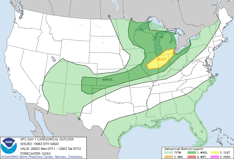
A corridor of higher MLCAPE (Figure 4) continued to surge northeastward after 00Z on July 12, 2022 within a modest low-level jet. The resultant low-level ThetaE plume helped sustain an in-bound axis of convection over western Lower Michigan oriented along/ahead of an inbound cold front. The front was guided along by a positively tilted shortwave trough digging across the Great Lakes (Figure 9). SPC placed most of Southeast Michigan within a Marginal Risk for severe weather, while areas along/south of I-94 were marked as Slight Risk (Figure 1). While damaging winds were the main threat for the event (15% probability), SPC did outlook the Slight Risk area with a 2% probability for tornadoes (Figure 3). The front exhibited characteristics of an active FGEN slope (Figure 7) as it crossed US-127 around 03Z. Effective shear on the order of 50 knots maintained a tilted storm strong for sustained mature updrafts (Figure 5). Given the nocturnal timing of the frontal passage, the main axis of convection was elevated in nature with the KDTX July 12 00Z sounding showing an elevated mixed-layer with a steep lapse rate (~7.5 C/km) . However, the lead storm became rooted in the boundary-layer and became surface-based which tapped into the modestly backed low-level wind profile reflected by mesoanalysis metrics of 150-200 m2/s2 of 0-1 km SRH. LCL heights in the 750-1000 m range were marginally low enough for tornadic development with the lead storm which exhibited strengthening velocity couplet just after 10:30 PM along with a tornado debris signature (a correlation-coefficient drop below 0.80) over Lake Fenton (see radar section). The front then exhibited a weakening trend as it progressed eastward with the southern extent crossing into a less favorable environment causing convection to decay into Metro Detroit.
SPC Outlooks
 |
 |
 |
| Figure 1: SPC Day 1 Severe Weather Outlook | Figure 2: Probability of Severe Wind | Figure 3: Probability of Tornado |
Near-Storm Environment Summary
 |
 |
 |
| Figure 4: Mixed-Layer Cape | Figure 5: Effective Wind Shear | Figure 6: Supercell Composite Parameter |
Additional Environmental Data
 |
.gif) |
 |
| Figure 7: Low-Level FGEN | Figure 8: 00z DTX Sounding | Figure 9: 500 MB Heights/Wind/Temps |
 |
Media use of NWS Web News Stories is encouraged! Please acknowledge the NWS as the source of any news information accessed from this site. |
|


