Both temperatures and precipitation across Southeast Lower Michigan by the end of 2004 finished near normal (with just a slight above normal bias). Looking back at the year, however, most would dispute that "near normal" term and analogy for the year since frequently, 2004 was anything but normal.
Both temperature and precipitation trends rode distinctive sine-wave (or roller-coaster) patterns seasonally, monthly and intra-monthly. While this type of pattern comes with the territory, it has tended to be more active, exaggerated and changeable the last few years. This has coincided with the basically Neutral to weak El Niño pattern that has existed over the Pacific Ocean along with prevalent NAO/EPO phases.
In a Neutral or a weak El Niño pattern, the Pacific Ocean has less of a moderating influence on our local changeable weather. Therefore, the chances for wider temperature and precipitation swings would be greater. In the longer term, however, these swings have a tendency to balance out (as evidenced in 2004). This is unlike the climate pattern of the late 1990s into early 2000's in which temperatures were more consistently above normal (even the year 2000 was generally mild but just one bitter cold month, December, with a -9° departure, pulled the annual temp back down closer to normal). Note the monthly temperatures and annual averages and trends since the late 1990s in Detroit.
| Year | Jan | Feb | Mar | Apr | May | Jun | Jul | Aug | Sep | Oct | Nov | Dec | Annual Temp |
|
| 1998 | 32.8 | 36.7 | 39.5 | 50.4 | 65.6 | 69.1 | 73.4 | 73.2 | 68.0 | 53.8 | 43.8 | 35.3 | 53.5 | Norm 49.7 (+/-0.5) |
| 1999 | 23.1 | 32.7 | 34.8 | 50.7 | 62.4 | 70.8 | 76.8 | 70.2 | 65.5 | 51.6 | 45.2 | 32.0 | 51.2 | |
| 2000 | 24.6 | 31.9 | 44.0 | 48.0 | 61.8 | 69.4 | 70.3 | 70.8 | 62.5 | 55.1 | 40.2 | 19.3 | 49.8 | |
| 2001 | 26.2 | 29.7 | 35.1 | 51.2 | 61.2 | 69.6 | 73.6 | 74.1 | 62.3 | 52.5 | 47.6 | 35.9 | 51.6 | |
| 2002 | 32.7 | 32.9 | 34.8 | 49.8 | 54.5 | 70.9 | 76.5 | 73.1 | 68.9 | 50.0 | 39.2 | 28.7 | 51.0 | |
| 2003 | 20.5 | 23.1 | 35.6 | 48.4 | 56.5 | 66.6 | 72.6 | 72.9 | 63.1 | 50.9 | 44.3 | 33.0 | 49.0 | |
| 2004 | 20.0 | 28.5 | 40.4 | 50.8 | 60.9 | 67.1 | 71.8 | 68.5 | 67.4 | 53.3 | 43.0 | 29.6 | 50.1 |
What had been a normal to above normal temperature trend, reversed (highlighted) and changed to a more normal to below temperature cycle (commencing late in 2002 /October/). In 2004, this cycle evolved into an above/below normal cycle (and coincidently, mainly aligning with the seasons). Thus, this resulted in annual temperatures for 2004 averaging around normal (while swinging between below and above normal) along with encouraging more volatile and changeable weather. While this trend is apparent at Detroit, it is camouflaged somewhat due to the urban heat island effect.
Season Fluctuations
Last winter's (2003-04) pattern also showed itself by way of frequently fluctuating temperatures and also ended up averaging "near normal" (to slightly below), in a winter that, ironically, was anything but normal. There were frequent wide monthly, weekly, and sometimes even daily, temperature swings along with an active storm track, especially in January.
The year of 2004 started out with January being an exceptionally cold and stormy month (after a deceivingly near record warm beginning, I might add). This pattern of mainly below normal temperatures held well into February. A mild change did come about by the latter third of February that helped turn the below normal departure into above (more about the individual months follows this annual summary, below). Total snowfall from the Winter of 2003-04 ranged widely from two feet /24.1"/ at Detroit Metro Airport, to over four feet at both Flint and Saginaw, to higher than five feet /62.6"/ here at the NWS in White Lake.
As the winter melted into spring, the pendulum swung the other way again to a warmer than normal spring (in fact, 7th warmest on record). While the winter was offset nicely by the warm spring, the spring contained excessively dry conditions in April and record breaking wet conditions in May. Nearly a century had passed since an April had been as dry as April 2004 /.69"/ in Detroit, placing it fourth for driest Aprils on record and Flint, with just .70", had its second driest April ever recorded. The tables turned abruptly again in May to excessively wet conditions. All stations (DTW/FNT/MBS/DTX) reported over eight inches of rain, which gave the region record or near record rainfall totals for May. Detroit with 8.46", had its wettest May on record (and second wettest month ever) which resulted in record flooding at some locations.
The Summer of 2004 contained some interesting weather patterns and trends of its own with nearly persistent unseasonably cool weather (landing in the record books as one of our cooler summers in recent memory). The Summer of 2004 also contained some storm totals and severe weather statistics superseding that of the records just set the summer (2003) before! The total amount of thunderstorm days during 2004, 42, ranks on the high side for annual thunderstorm days (and just below the top ten stormiest years with number 10 at 44 storms). The average thunderstorm days for Detroit is 33, while the highest amount ever observed was 53 days back in 1917.
As autumn got into full swing, the roller-coaster weather pattern got into higher gear. The first month of autumn, September, actually better represented a typical nice summer month rather than a fall month. This was a meteorological bonus considering what the summer was like. Temperatures averaged considerably above normal in September and at the same time, it was one of the driest Septembers on record. A sharp about-face in the jet stream from the north in early October, brought near record cold the first week of October but this too, was offset by near record warmth at the close of the month. (dizzy yet?)
Late fall into early winter 2004-05 brought a stormy, wet pattern with several shots of rain and snow. Ironically, the years end was most fitting with December and its wild temperature swings and stormy pattern. In the end, however, (and just like the year), the overall monthly temperature averaged right on normal, in a month that was also, anything but.
| 2004 | Jan | Feb | Mar | Apr | May | Jun | Jul | Aug | Sep | Oct | Nov | Dec | Annual | Depart |
| Temp | 20.0 | 28.5 | 40.4 | 50.8 | 60.9 | 67.1 | 71.8 | 68.5 | 67.4 | 53.3 | 43.0 | 29.6 | 50.1 | +.4 |
| Pcpn | 1.43 | 0.63 | 3.29 | 0.69 | 8.46 | 2.86 | 2.85 | 4.52 | 0.65 | 2.08 | 3.21 | 2.91 | 33.58 | +.69 |
| (See monthly graphs below for additional info) | ||||||||||||||

So persistent was the cold and snow that one may forget that the month Actually began "tropical". The high temperature hit 57 on the 2nd and 58 on the 3rd! It was pretty much downhill temperature-wise the rest of the month with the average temperature for the month still managing to average -4.5 with 20.0 degrees even. If one eliminated just the first three days of the month, the average temperature for January would have dropped 2.4 degrees to 17.6 (making January 2004, the 12th coldest on record, instead of not even placing in the top 20). The January average of 15.8 degrees here at the NWS in White Lake was officially the coldest month on record so far since records began in November 1995.
The coldest January night occurred late in the month with a heavy snow cover on the 24th-25th. A -15 was registered here at the NWS, while in Downtown Detroit the temperature fell to -2 at City Airport and -7 at Metro. The last time the temperature fell lower than -7 at Detroit Metro Airport was just over five years ago on 1/5/99 (and just after our big 1/2/99 snowstorm) when the mercury plummeted to -10.
The month was active with Colorado/Texas Panhandle Lows and Alberta Clippers from Canada. One of the most noteworthy storms occurred on the 14th, when a rather "wet" and well developed clipper scooted across the southern Great Lakes. In its wake, snowfalls ranged from around 2" close to the Ohio border, to as much as a foot over portions of central and northern Oakland and St Clair County.
Another low moved into the Upper Ohio Valley on the 27th left 1" to 7" of snow across extreme southeast lower Michigan. Again, snowfalls ranged from an inch or two near the Ohio border, while 6" to 7" fell over northern Washtenaw and Oakland Counties into all of Livingston County. Snowfall totals for the month were quite variable. Around a foot or less fell over the extreme southeast corner of Lower Michigan, while amounts easily exceeded two feet over portions of the northern suburbs.

After a riotous and ruckus January with an over abundance of snow and cold, Mom Nature gave us somewhat of a break in February. While temperatures continued to average below normal for the first two thirds of the month, the relatively mild and nice ending of the month offset the earlier cold. By the close of February, the monthly average temperature managed to climb out of the hole and actually place above normal /+1.3/ for the month. Actually, three days during the month (20, 28, 29th) were most instrumental in turning that negative departure, into a positive. First off, on the 20th, the temperature climbed to 50 degrees and that was the first time the temperature rose above to 50 since January 3rd. Later in the month, a high temperatures again Rose back into the 50s (50/28th and 56/29th).
Not only did we get a break from the cold temperatures later in the month, we got a break from snow. Only about an inch /0.9"/ of snow fell at Detroit Metro Airport the entire month, while 7.6" fell here at the NWS in White Lake. That snowfall total of 0.9" at metro ranked February in third place for least amount of snowfall.
The overall weather during February was rather benign as far as storms and precipitation. as evidenced by the record February dryness (13th place) as all rain and snow events were on the light side.

After a relatively mild ending to February, March continued that pace with above normal temperatures. One thing that did change, however, was the notable increase in rainfall. While only a little better than half an inch /.63/ of precipitation fell in February, March's total of 3.29 not only handily beat the monthly normal /2.52/ but it also came fairly close to the 20th wettest March on record /3.46-1997/.
March opened unseasonably mild and wet and by the end of the first week, temperatures averaged close to 46 degrees (or about 13 degrees above the normal /33/ for early March). The mercury surged up to 68 on the 5th and handily broke the old record high /64-1935/. An intense low pressure system and strong cold front pushed through Michigan late on the 5th, bringing a squall of showers and a wind gust to 59 mph at Detroit Metro Airport.
Following the aftermath of the storm's colder surge on the 5th, readings held closer to normal during much of the second week of March. A second wave of much colder weather, along with a swath of snow, accompanied a storm as it pushed its way through the northern Ohio Valley, just in time for St Patrick's Day. Snowfalls of mainly two to five inches /16th/ fell on the area as high temperatures hovered around 30 both days (16th/17th), some 15 degrees below normal.
Rather than cold and snowy, the first day of spring /20th/ actually arrived somewhat "appropriate" for a change, with readings rising to near 60 along with sunshine, heavy rain and even thunderstorms. One big negative was that the spring weather lasted only one day. Another surge of polar air followed and dropped high temperatures back into the 30s. After that spring-like opening on the 20th, just two days later /22nd/, overnight lows dropped down well into the teens! But alas, it too didn't last as warmer air pushed back in during the final week of March, bringing occasional showers and partly cloudy conditions.
Like March's opening week, much of its final week also contained unseasonably mild weather. Highs rose back up into the 50s and 60s that is, until the lion visited at its close /30th-31st/ when cold, wet and dreary weather helped erase any fond memories of our first spring month. The 2003-04 Winter Review can be found here.

It had been nearly a century since an April had been this dry in Metro Detroit area. At just .69 of an inch of precipitation, April 2004 placed fourth driest April on record in Detroit. The last time it was drier in April was way back at 1915 when only .66 of an inch fell /third driest/.
The wettest day during the month was the .34 of an inch that fell on 21st (mainly due to a thunderstorm), which was about half the entire month's amount! The .69 of an inch was well below the average we usually measure /3.05/. Here at the NWS in White Lake, the measly .39 of an inch for the month turned out to be the driest month ever since records began in November 1995!
While the average temperature for the month /50.8/ averaged above normal and placed in at the 17th warmest April, the first half of the month actually averaged below normal. The resultant warm month was mainly due to a couple of brief strong warm spells. Temperatures from the 16th through the 19th pushed well up in the 70s and 80s, averaging some 17 degrees above normal. During that warm stretch, a record high temperature of 86 degrees was set at Detroit on the 18th (old record 84/2002). Then, a couple of warm Days (29/30) with highs of 81 and 72 averaged about 14 degrees above normal. Interestingly, and keeping within our see-saw pattern lately, after our 80s mid month, another cold blast late in the month /27th/ still was able to bring snow showers to the region.
Since the month lacked rainfall, severe weather events were basically kept at bay. A strong low pressure and cold front, however, did plow across the great lakes on the 18-19th. Strong winds associated with the low gusted mainly up into the 30s and 40s /mph/. Officially At Detroit Metro Airport the wind gusted to 44 mph, while here at White lake the wind reached 50 mph. And as one would expect being a dry and relatively mild April, snowfall was next to zilch at Detroit where only a trace fell. Here at the NWS in White Lake, Only .9 tenths of an inch was measured.
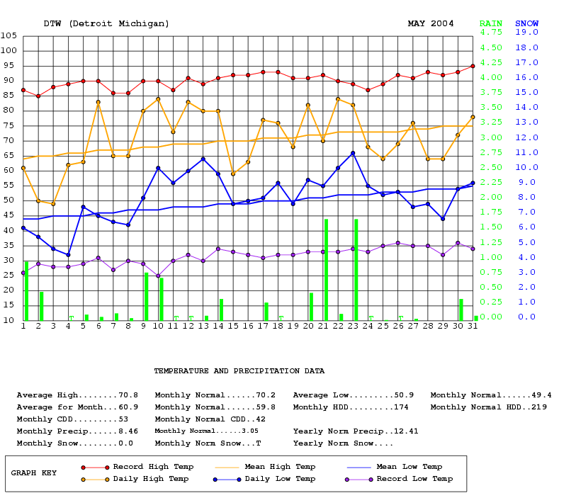
Never in the history of climate records for Detroit has a May been this stormy or wet across the Metro Detroit area. In addition to this climate write-up, a Public Information Statement regarding the rain, storms, flooding and severe weather warnings was created.
May of 2004 easily topped the list for wettest Mays on record with 8.46". The old record of 8.05" was set 61 years ago in 1943. The 8.46" total also easily moved into second place for wettest months on record. The previous second place record was 8.33", set in August 1926. The highest rainfall ever measured in a month at Detroit still remains the first place at 8.76", set way back in July of 1878! Therefore, the 8.46 inches that fell in May 2004 was the most rain officially observed at Detroit in any month in 126 years! The 8.55" that fell here at the NWS in White Lake was the most rain observed for a month since records began in Nov 1995. In addition, our wettest month here at the NWS in White Lake was preceded by the driest month on record (April with 0.39).
TOTAL DAYS WITH THUNDERSTORMS IN MAY BREAKS MAY'S OLD RECORD AND TIES FIRST PLACE FOR ANY MONTH (AND ALL PREVIOUS RECORDS ARE OVER 100 YEARS OLD)
Numerous thunderstorms during the month brought the amount of thunderstorm days to 14. This blew away the old record of thunderstorm days for the month of May which was 11 and set way back again in the 19th century /1896/. The 14 days of storms that occurred this May also tied June of 1892 and July 1902.
SEVERE THUNDERSTORM WIND ON 23RD OF 78 MPH FLIRTS WITH RECORD TERRITORY AT DETROIT METRO AIRPORT
While the wind gust of 78 mph was not a record wind gust for Detroit Metro airport (that record is 94 mph on 6/26/73 also during at severe thunderstorm), it was the strongest wind gust that was officially recorded at Metro since 1973. Another storm (within derecho type thunderstorms) also is in the same ballpark as this May's wind gust and occurred back on July 16th, 1980. While isolated wind gusts of around 100 mph were reported in southeast lower Michigan (outside of Metro Airport) that /16th/ morning, officially at Metro, a 75 mph wind gust was clocked. The strongest wind observed officially for Detroit was way back on June 17th, 1890 when a wind speed of 125 mph was registered.
24 HOUR RAINFALL ON MAY 20TH-21ST OVER TWO INCHES BUT NOT A RECORD AMOUNT OF RAIN IN A 24 HOUR PERIOD FOR MAY
The rainfall dumped on the area on the 20th-21st /2.15"/, however, did attempt to challenge the all time 24 hour record for the month of May (2.87 - 5/26-27/1968). The greatest rainfall for a calendar day in May also fell at this time with 2.56" falling on May 26th alone. The calendar day rainfall of 1.69 on both the 21st and 23rd were rainfall records for both dates this may.
Since the month averaged 1.1 degrees above normal, it was the fourth month in a row with above normal temperatures. The past three spring months made for one of our warmer springs on record. There were no record highs nor lows during the otherwise, very active month.
Spring of 2004 ended up in the record books as the 7TH warmest and 8TH wettest.

The unusually stormy and wet pattern that commenced early in May, showed signs of calming down by mid June after six weeks of storms, severe weather and flooding. A definitive upper wind shift to the northwest was a welcome change by mid month. While this northwest flow brought notably drier and cooler conditions, it also brought very pleasant early summer weather.
Despite the change later in the month, June still was an active month by way of thunderstorms (due to clashing air masses). Storms were observed seven days during June (normal is 6). That, added to the 14 thunderstorm days of May (well above the normal of 4), equaled the average amount /21/ for the entire May-august period. Severe thunderstorms containing hail were most noteworthy on the 9th, 13th and 14th.
The active first part of June brought above normal rainfall again With nearly two and three quarters of an inch /2.72/ falling by The 17th. However, with only .14 of an inch falling the remainder Of the month, this left only 2.86 for the month, or .69 of an inch below normal. This dry spell actually was welcome after the foot of rain (some locations even more) fell in about a six week (May – mid June) period over portions of southeast lower Michigan. Much of the region saw over a third of the normal annual rainfall in just the six week period from May - mid June. Here at the NWS in White Lake, June's rainfall was higher at nearly four inches /3.94/. This amount, combined with May's total of 8.55, gives a two month total of 12.49" which really helped raise the inland lake levels for the time being.
There were only two really uncomfortable days in June, (8/9th), when temperatures rose into the 80s/90s on the 8/9th and with relatively high humidity, it felt closer to the upper 90s. While the temperatures during the first half of June averaged above normal, the second half averaged below normal, so much so, that June's final average temperature actually dropped to 67.1, nearly two degrees /1.9/ below normal. Some impressive surges of polar air routinely pushed into eastern half of the country during the last 12 days of the month. Temperatures fell into the 40s and 50s for several nights straight (19th - 30th). While no record lows were set, the extent and duration of the cool conditions were exceptional. On the morning of the 20th, readings as low as 41 degrees in White Lake.

Like last July, temperatures this July also averaged below normal, but even more so. The mean temperature of 71.8 was 1.7 degrees below normal (last July averaged 72.6 or close to a degree below normal). Also similar to last July, ninety degree days were scarce with only one occurring this July compared to two last July. Usually we have about five days during July when the temperature rises to 90 or above. The lack of 90s, however, in part resulted in July being a rather pleasant month. The average high of 81.1 degrees in July was over two degrees below the normal high of 83.4. In addition, about two thirds of the month /19 days to be exact/, the daily temperature averaged below normal. One day in particular /27th/ was an exceptionally cool and miserable day for late July. The high temperature reached just 64 degrees, falling well below the record low maximum for the date of 70, set way back on July 27th 1874. Adding insult to injury, the high Of 64 degrees occurred just after midnight! Temperatures hovered in the mid 50s to around 60 during the afternoon hours of the 27th as a steady rain fell. It was also the coolest July 27th on record since 1870, overall, with an average temperature for the day of 61 degrees. While no official records can be quoted, it is pretty safe to say that it is unusual in July to have cooler afternoon temperatures than at midnight.
As with many summer months, rainfall during July varied across Southeast Lower Michigan with portions of the northern suburbs seeing heavier amounts of rain. As an example, here at the NWS in White Lake, nearly five and a half inches fell /5.43/ but Detroit Metro Airport recorded slightly below normal rainfall with 2.85. While days containing thunderstorms totaled up to the average (six), severe weather became less frequent during the month. The most notable severe weather event took place late on the 13th into the 14th. A cold front spawned lines of strong to severe thunderstorms while it pushed through the region. Numerous reports of hail and high winds were received here at the NWS.
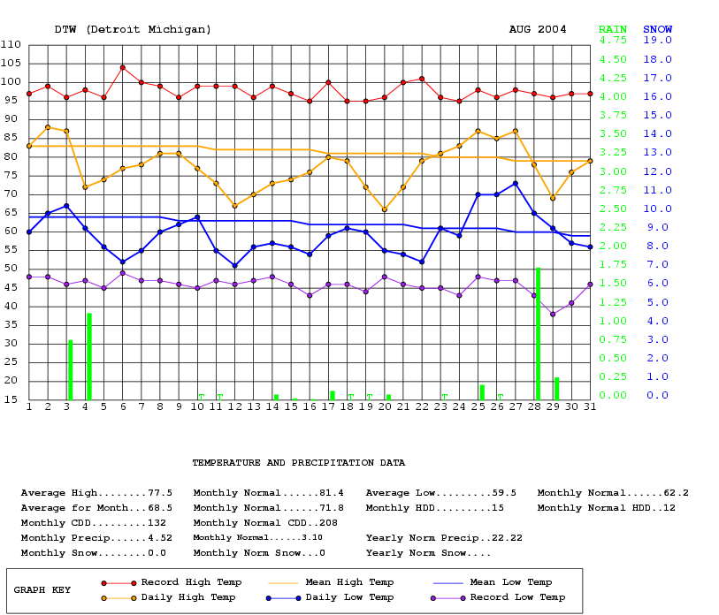
Usually one of our warmest and nicest summer months, August this summer was cool and wet. Out of the 31 days in August, 23 days averaged below normal. Had it not been for the warmer period late in the month, the average temperature for the month would have been notably cooler. In fact, as of the 23rd of the month, the temperature averaged a relatively chilly 67.2 degrees, rather than the final August reading of 68.5 degrees (or 1.3 cooler). Ironically, that 67.2 degrees would have placed the month at eighth coolest August rather than an almost negligible 19th coolest. Furthermore, the period of late July through mid August was an extraordinarily cool period, When compared to it usually being one of the warmest (more about this in the "Summer of 2004" write-up).
No 90 degrees days were recorded during August, generally we feel about three, which coincidently, was the total for the entire summer season. The effects of the heat island around the city of Detroit stood out remarkably well in August. While Detroit's average temperature for August was 68.5, here in White Lake it was only 64.4, or over four degrees /4.1/ colder.
Thunderstorms were again copious over much of the region with ten days of recorded thunderstorms in Detroit. Typically, the area experiences half that amount /5/ of storms. In a given August (it's been a stormy season again, more on that in the summer review, too). Thunderstorms containing very heavy rain associated with a slow moving frontal system during the last weekend of the month filled rain buckets to the brim at many locations. Officially, 1.77 inches of rain fell on the 28th which broke the previous excessive rainfall record of 1.24 in 1909. Much of extreme Southeast Lower Michigan had an inch or two of Rain on the last weekend of August /28-29th/. The 4.52 inches recorded at Detroit Metro made it the 20th wettest August since records commenced in 1870.

Michigan is known for its changeable weather but it seems like Mother Nature has been working overtime lately and September was no exception.
After inhabitants of Southeast Lower Michigan dealt with a nearly persistently cool summer, September bounced back big time with numerous beautiful sunny days and summer-like temperatures. In fact, for most of the month, the average temperature for September hovered from the upper 60s to mid 70s. Interestingly, by the third week of September, the average temperature of 69, would have placed the month in fourth place for warmest (right next to September of 2002 /68.9/). Even more notably, much of September was warmer than either past summer month of June /67.1/ or August /68.5/ across Metro Detroit! In the final analysis, however, with a cool down late in the month, the average temperature slipped down to 67.4, placing this September in 15th place for warmest Septembers on record.
After a stormy late spring and summer, Mom Nature also (for the most part), shut off the waterspout in September. None of the four climate stations (Detroit-Flint-Saginaw and White Lake) had even an inch of rain this month. This is in stark contrast to the beginning of the growing season where all four stations had better than eight inches of rain in May.
No thunderstorms were observed in September, this coming after each month since May contained a surplus of storms. The most notable record to come out of September (including the first day of October), however, was the record amount of consecutive dry days. The last rainfall in September was sep 8th when just .05" fell. Therefore, through Oct 1st it was over 22 1/2 days with no rain and none fell until the 2nd. Nearly a century ago /96 years/, back in yet another September, Sep 1908), it ceased raining for 22 1/2 days at Detroit (not even a trace was recorded). This record ran from Sep 2nd through the 23rd in 1908. Therefore, a new record for rainless days in Detroit was set.

October was pretty much cooler than on average for about the first two thirds of the month with temperatures averaging a couple of degrees below normal by the 20th. Big changes in the upper wind flow to a predominant southwest flow took place during the last third of the month and brought much warmer weather to the region. Temperatures pushed well up into the 60s throughout the last week of the month and peaked at 75 degrees on the 30th (second highest temperature of the month and just one degree shy of tying the record - 76/1999). That wasn't the only thing "peaking" that day as an intense low pressure surged through the great lakes and brought very strong winds. The storm Center (central pressure near 29.00 inches) caused wind gusts to peak as high as the 50s and 60s /mph/. Most wind gusts across much of extreme Southeast Lower Michigan were fairly uniform in the mid 50s as evidenced by the following: at Detroit Metro Airport the wind peaked at 56 mph, NWS White Lake at 55 mph, Ann Arbor 56 mph, Howell 55 mph, Monroe 54 mph and Ypsilanti at 55 mph. Unofficial wind gusts were reported in the mid 60s at a few locations in Detroit's northern suburbs. Several reports of downed tree branches and power outages were noted along with some widely scattered damage.
As stated above, October had been a cool month, especially in the beginning when temperatures fell into the mid 30s with several mornings during the first week having some frosty conditions. A low of 35 degrees on 5th at Detroit Metro - and 25 degrees here at White Lake - was accompanied by a killing frost and hard freeze in Detroit's north/west suburbs. Later on the 17th/18th, another plunge of polar air brought temperature back down into the 30s and for the most part, ended the growing season for 2004 across the remainder of Southeast Lower Michigan.

When looking over all of November, it actually was a fairly nice month for the most part. In fact, by mid month the actual sunshine was running nearly double /63%/ that of the normal /35%/. Unfortunately, that pace did not continue as the more common dreary days of November arrived more frequently the latter half of the month, dropping that 63% average down to near 41% at month's end (but still above the normal and in the top 25% for sunniest Novembers since 1891).
Along with the above average sunshine came the above normal Temperatures, particularly the third week of the month /16th- 23rd/. Indian summer-like weather visited once again with readings averaging close to ten degrees above normal. This warm spell hit its apex on the 18th when the mercury shot up to 66 degrees, just three degrees shy of the record /69-1941/! This mid-month warmth was responsible for the above normal average for the month as the remaining three weeks actually averaged normal to below.
When the jet stream abruptly shifted to a more northerly direction temperatures were near or below seasonal levels late in the month. The shift (and resulting mix) in the jet stream allowed it to become more prolific in storm development. The most substantial (and seasonal) storm center to affect the area this month came in time for Thanksgiving. A deepening low pressure system tracked into the eastern lower Great Lakes on Thanksgiving Eve. The storm brought a swath of heavy snow and rain across much of Southern Lower Michigan. The rain/snow line from This system was quite discernible from snow spotter reports and confirmed on satellite over the region come Thanksgiving morning. Heaviest snow fell well west and north of the Detroit area with generally an inch to three inches from Detroit into the western and northern suburbs. Further out, three to as much as eight inches was reported northwest of a line from Port Huron, through Pontiac to the Chelsea area (in Washtenaw county). All in all, it created a nice "Christmas atmosphere" for Thanksgiving. Despite the storm, officially Detroit Metro Airport received just a tenth of an inch (for the day and November). This was well below the normal of 2.7" for the month, while many areas west/north of Metro Airport in Southeast Lower Michigan received above normal snow for November.
A second storm center, west of the area, brought milder weather and rain into the region Thanksgiving Weekend. As the month ended /30th/, yet another storm system brought a wintry mix of rain and snow as we "slid" into December.

December was an active month weather-wise across the region with weather systems frequently traversing the area and bringing above normal amounts of both rain and snow.
Right from the start, a low pressure system pushing through northwest Ohio on the 1st brought a broad area of rain and snow across Southeast Lower Michigan. While mainly rain fell south of Detroit, mostly snow fell north with over three inches /3.3"/ recorded here at the NWS.
After a day or two of near normal temperatures, temperatures rose up into the 40s through the 6th. Shortly after, an intense storm center accompanied by strong winds prompted a high wind advisory across the area as it moved toward Southern Michigan on the 7th. Along with the wind, the heaviest rains of the month rode into the region on a surge of warm air. Rainfall amounts measured well over an inch /1.20/ at Detroit on the 7th, while White Lake received .85".
An extensive area (for December) of heavy rain (1-1/2") was recorded across extreme Southeast Lower Michigan from this storm. Detroit's official high of 59 was only three degrees shy of the 62 degree record /1951/. As the center of the storm tracked across metro Detroit, the central pressure was measured 29.15" and thus, strong winds of 25 to 35 mph gusted well into the 40s (Detroit Metro /DTW/ - 45 mph).
A two day interval of dry weather was quickly a memory as yet another strong storm rode east through the Southern Great Lakes on the 10th - 12th. Rain ahead the storm changed over to snow as polar cold front followed the system. A reinforcing blast of cold air brought more snow (1-4") to the region on the 12-13th.
The above systems signaled a change in the upper jet stream to a strong northwest flow that lasted until the last few days of the month. The first of a couple of impressive Arctic air masses blew into the Great Lakes on the 19th and plummeted nighttime lows to near zero or below (the first of the winter season). Across the west and northern suburbs, many readings fell well below zero. In White Lake, the NWS recorded a low of -8/19th and -12/20th. That -12 on Dec 20th was the lowest temperature recorded so early in the season at the NWS.
While on the subject of the NWS White Lake, other notable December Records were attained:
December 2004 turned out to be the wettest December in the ten year record span with 3.64" (the next highest is down at 3.16" in 1995). We measured 23.3" of snow at the NWS and placed a respectable second for snowiest December.
In spite of the high weather volatility in December, no record highs or lows were set officially at Detroit along with no placements in the top 20 records.
The above normal snow across the region was mainly the result of the pre-Christmas snowstorm (12/23). The strong storm brought blizzard or near blizzard conditions in the Thumb region down into St Clair County, while the remaining area saw heavy snow and widespread drifting.
In about 12 hours, generally 6-10" of snow fell and officially at Detroit Metro Airport, 8.8" of snow was reported, while snowfall totaled 8.0" here in White Lake.
The snowstorm provided a deep snow cover for a white Christmas but with bitterly cold temperatures. Temperatures plummeted down into the sub-zero range (and near record cold) for the second time this month. Readings ranged from a degree or two below zero in the city of Detroit, to the teens below zero in a few suburban or rural areas. Detroit Metro Airport dropped to -4 (and not too far from the record low -10/1983).
The Christmas week (24-31st) played out the temperature roller-coaster pattern in these parts to a tee. As stated above, the week started out with bitter cold and below zero temperatures, then readings moderated slowly through the 20s and 30s, that is, until New Year's Eve Day. A strong warm front pushed across the region late on the 30th And ushered in a strong southwest flow that pushed readings well into The 50s to near 60 (and this time near record warmth)! Some places in Southeast Lower Michigan showed a temperature range of over 70 degrees from the bitter cold /0 to -13/ on the 19th, 20th, 25th and 27th to comparative surging warmth (near 60) as New Year's Eve approached.

