Overview
Event Summary
Please note: Due to the nature of the storm with lighter blowing snow early Saturday morning and wet snow/mix later on, measuring the snowfall was quite difficult leading to variations across small distances.
Snow quickly moved in during the late evening on Friday, January 17, 2020 as a strong low pressure system moved in from the Midwest and across the Great Lakes region. This strong system brought numerous advisories and warnings to the Midwest and Great Lakes. The majority of the snow fell overnight and into the morning hours on Saturday before tapering off and transitioning to rain showers and drizzle over some parts of Southeast Michigan. Snow, rain and sleet were all seen over the course of the later morning into early Saturday morning. With the amount of moisture that was available with this system, the characteristic of this snow was heavy and wet, making shoveling rather difficult. During the heaviest snow, snowfall rates were 1+ inches per hour leading to many locations seeing 5 to 7 inches of total snow.
Snowfall Totals
For more detailed snow reports, please see the storm reports tab.

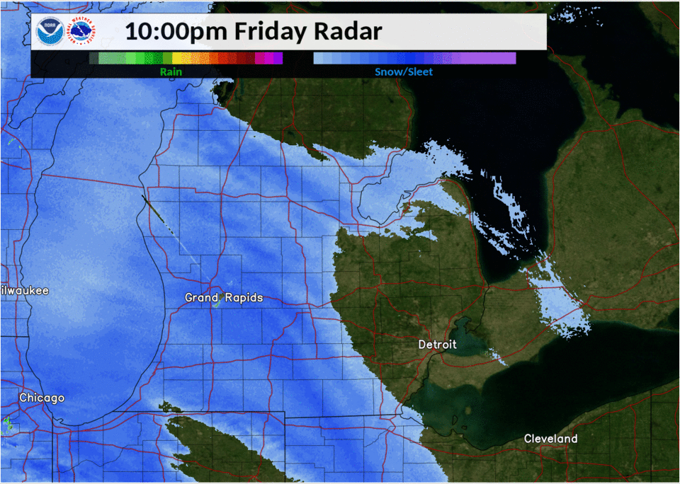
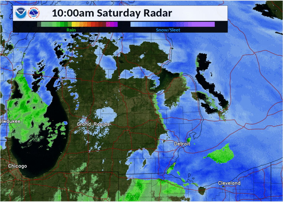
Radar
 |
 |
 |
|
Radar Loop of Snow Event from 10 PM Friday to 4 AM Saturday |
Radar Loop of Snow Event from 4AM to 10 AM Saturday |
Radar Loop of Snow Event from 10 AM to 1:50 PM Saturday |
Storm Reports
Snowfall reports from the last 24 hours can be found here.

The latest Local Storm Reports (LSR) (text format), along with the Public Information System (PNS) can be found here.
Public Information Statement...Storm Totals
National Weather Service Detroit/Pontiac MI
323 PM EST Sat Jan 18 2020


STORM TOTAL SNOW REPORTS

Location                  Snowfall     Duration
                          (Inches)      (Hours)        Lat       Lon

...Bay County...
   Kawkawlin               M   4.0            M     43.65N    83.95W

...Genesee County...
   Grand Blanc             M   5.5            M     42.93N    83.62W
   Linden                  M   5.8            M     42.82N    83.78W
   Clio                    M   6.5            M     43.18N    83.74W
   3 SW Flint              M   7.2            M     43.00N    83.74W

...Huron County...
   Bad Axe                 M   5.0
   Port Austin             M   4.0

...Lapeer County...
   Otter Lake              M   2.5            M     43.21N    83.46W
   Imlay City              M   3.8            M     43.02N    83.08W
   Elba                    M   4.0            M     43.04N    83.44W
   Metamora                M   4.2            M     42.94N    83.29W
   1 NW Lapeer             M   5.6            M     43.06N    83.34W

...Lenawee County...
   Morenci                 M   3.2            M     41.72N    84.22W
   Adrian                  M   6.4            M     41.90N    84.04W

...Livingston County...
   2 N Whitmore Lake       M   5.8            M     42.46N    83.75W
   Brighton                M   5.8            M     42.53N    83.78W
   Hartland                M   5.8            M     42.66N    83.75W
   Cohoctah                M   6.1            M     42.76N    83.95W
   4 NW Pinckney           M   6.3            M     42.50N    84.00W

...Macomb County...
   4 SW Sterling Heights   M   5.1            M     42.54N    83.09W
   Sterling Heights        M   5.1            M     42.58N    83.03W
   Armada                  M   6.2            M     42.84N    82.88W
   Chesterfield Township   M   6.4            M     42.68N    82.82W
   5 N Grosse Pointe       M   6.8            M     42.47N    82.92W
   Roseville               M   6.8            M     42.51N    82.94W
   Shelby Township         M   6.9            M     42.67N    83.03W
   Macomb Township         M   7.0            M     42.67N    82.92W
   Washington              M   7.1            M     42.72N    83.04W
   St. Clair Shores        M   7.5            M     42.49N    82.89W

...Midland County...
   8 S Midland             M   4.5            M     43.51N    84.23W
   Midland                 M   4.8            M     43.62N    84.23W

...Monroe County...
   Temperance              M   3.2            M     41.77N    83.57W
   1 SE Monroe             M   4.0            M     41.91N    83.37W
   Dundee                  M   5.2            M     41.96N    83.66W
   3 SE Newport            M   6.4            M     41.97N    83.27W
   Stony Point             M   6.4            M     41.95N    83.27W

...Oakland County...
   1 N West Bloomfield     M   4.5            M     42.58N    83.38W
   2 WSW Wolverine Lake    M   5.0            M     42.55N    83.51W
   Lake Orion              M   5.0            M     42.78N    83.24W
   Ortonville              M   5.0            M     42.85N    83.44W
   Waterford               M   5.0            M     42.66N    83.39W
   White Lake              M   5.1            M     42.65N    83.50W
   2 E Novi                M   5.4            M     42.48N    83.45W
   Farmington Hills        M   6.0            M     42.49N    83.38W
   Highland                M   6.0            M     42.64N    83.62W
   Leonard                 M   6.0            M     42.87N    83.14W
   Beverly Hills           M   6.2            M     42.52N    83.22W
   Berkley                 M   6.4            M     42.50N    83.19W
   Clarkston               M   6.5            M     42.74N    83.42W
   2 NW West Bloomfield    M   6.8            M     42.59N    83.41W
   Royal Oak               M   6.9            M     42.51N    83.15W
   Rochester Hills         M   7.0            M     42.67N    83.16W
   2 W Novi                M   7.7            M     42.48N    83.53W

...Saginaw County...
   5 NW Saginaw            M   3.0            M     43.47N    84.02W
   3 W Saginaw             M   4.5            M     43.42N    84.01W
   Carrollton              M   5.0            M     43.46N    83.93W
   Oakley                  M   5.5            M     43.14N    84.17W
   Shields                 M   5.5            M     43.42N    84.07W

...Sanilac County...
   Peck                    M   4.3            M     43.26N    82.82W

...Shiawassee County...
   Owosso                  E   4.0            M     43.00N    84.18W
   New Lothrop             M   4.5            M     43.12N    83.97W

...St. Clair County...
   Port Huron              M   3.1            M     42.99N    82.43W
   Yale                    M   3.5            M     43.13N    82.80W

...Washtenaw County...
   Milan                   M   4.0            M     42.09N    83.68W
   Manchester              M   4.5            M     42.15N    84.04W
   Saline                  M   5.7            M     42.18N    83.78W
   Ypsilanti               M   6.4            M     42.24N    83.62W

...Wayne County...
   Garden City             M   5.7            M     42.33N    83.33W
   Detroit                 M   5.8            M     42.38N    83.11W
   Livonia                 M   6.5            M     42.40N    83.37W
   Wyandotte               M   6.7            M     42.21N    83.16W
   2 E Romulus             M   6.8            M     42.23N    83.32W
   Northville              M   6.8            M     42.44N    83.49W


M = Measured
E = Estimated
 |
Media use of NWS Web News Stories is encouraged! Please acknowledge the NWS as the source of any news information accessed from this site. |
|

