Overview
The first severe weather and tornado event for 2019 in Southeast Michigan occurred on Thursday, March 14. A Severe Thunderstorm Watch was issued for the entire county warning area (CWA) late Thursday afternoon. Numerous Severe Thunderstorm Warnings were issued, along with Tornado Warnings. A large, powerful low pressure system moved up across the central Plains, with weather ranging from blizzards to tornadoes. There were two rounds of weather that occurred across Southeast Michigan, the first round of severe weather raced northeast across the area as storms traveled at 100 mph! (Please note, that the storms were traveling near 100 mph, but the winds were only around 40-50 mph at the surface.) The second round of severe weather, which is what brought the tornadoes to the area, was a line of thunderstorms that moved northeast just ahead of a cold front. As this line moved across the area, there were multiple areas of circulation embedded with the line which resulted in four tornado touchdowns across Shiawassee and Genesee counties. Three out of the four tornadoes were weak and rated an EF-0. The tornado that hit near Vernon, MI, was rated an EF-2. Some debris (insulation/lighter metal) from the M-71 area in Vernon was carried 7 miles by the tornado!
Tornadoes:
|
|
||||||||||
|
||||||||||
|
Tornado 1 - SSW of Corunna, MI
Track Map  
Radar Velocity Image at 6:47 PM EDT Inbound velocities (green) located next to outbound velocities (red)
|
||||||||||||||||
|
Tornado 2 - Vernon, MI
Track Map 
Radar Velocity Image (left) at 6:57 PM EDT Inbound velocities (green) located next to outbound velocities (red) Radar Correlation Coefficient (CC) Image (right) Blue area indicates debris being lofted into the air, which is being picked
|
||||||||||||||||
|
Tornado 3 - Flushing, MI
Track Map 
Radar Velocity Image at 7:09 PM EDT Inbound velocities (green) located next to outbound velocities (red) |
||||||||||||||||
|
Tornado 4 - Genesee Township, MI
Track Map 
Radar Velocity Image at 7:25 PM EDT Inbound velocities (green) located next to outbound velocities (red) |
||||||||||||||||
The Enhanced Fujita (EF) Scale classifies tornadoes into the following categories:
| EF0 Weak 65-85 mph |
EF1 Moderate 86-110 mph |
EF2 Significant 111-135 mph |
EF3 Severe 136-165 mph |
EF4 Extreme 166-200 mph |
EF5 Catastrophic 200+ mph |
 |
|||||
Photos & Video
WOOD TV Channel 8 Story on Tornadoes
 |
 |
 |
 |
| Southwest of Lennon, MI (Channel 25 Flint) |
Vernon, MI (CJ Postal) |
Vernon, MI (CJ Postal) |
Vernon, MI (CJ Postal) |
 |
 |
 |
 |
| Vernon, MI (Jim Barrett) |
Roseville, MI (Anthony Robart) |
Columbus Township, MI (Amanda Jane K.) |
Owosso, MI (Bailey Cook Leppert) |
 |
 |
 |
 |
| Flushing, MI (Lindsi Letts) |
Flushing, MI (Lindsi Letts) |
Dexter, MI (Dan Robelen) |
Dexter, MI (Dan Robelen) |
Radar
 |
 |
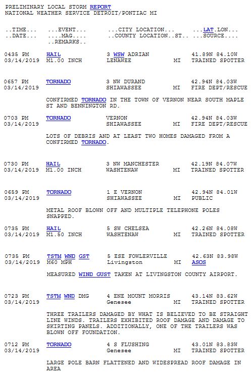
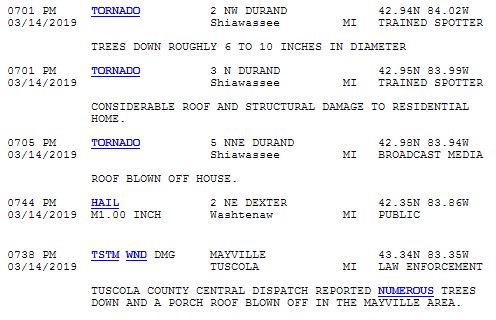
Storm Reports
 |
 |
|
Public Information Statement (PNS) for Tornado 1 near Corunna, MI |
Public Information Statement (PNS) for Tornado 2 near Vernon, MI |
 |
 |
|
Public Information Statement (PNS) for Tornado 3 near Flushing, MI |
Public Information Statement (PNS) for Tornado 4 near Genesee Township, MI |
 |
|
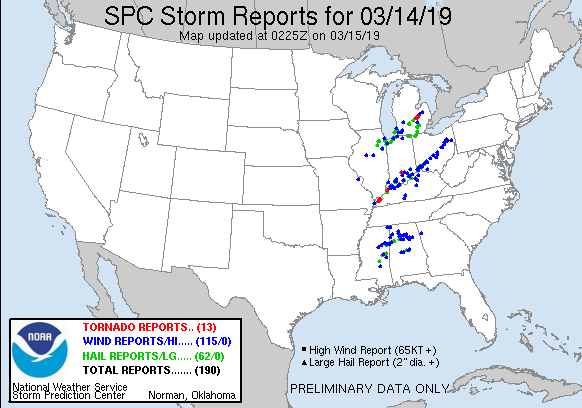
Above image depicts that local storm reports and warnings across the region on Thursday, March 14th, 2019. |
Environment
A strong low pressure system lifted northeast from the central Plains into the central Great Lakes the afternoon and evening of March 14, 2019. Strong dynamics associated with this system aided in the transport of anomalously warm and moist air into lower Michigan. Multiple rounds of severe weather occurred with this strong low pressure system, with reports of damaging winds, large hail, and 4 tornadoes across portions of southeast Michigan. The hardest hit areas were across Shiawassee, Genesee, and Tuscola counties, and across portions of Lenawee and Washtenaw counties. The bulk of severe weather reports came from a line of strong to severe thunderstorms that moved from west to east across southeast Michigan between 6 PM and 10 PM. Luckily, there were no reports of injuries or deaths associated with the severe weather.
The low pressure center tracked northwest of southeast Michigan, lifting a convergence of frontal boundaries known as a triple point across southeast Michigan (Figure 1). The convergence of these frontal boundaries provided a source of lift for the thunderstorms to develop. The atmospheric setup for this event was impressive, especially for March standards. As Figure 2 depicts, the observed sounding profile taken at KDTX roughly during the peak of the event, revealed a more than favorable thermodynamic and kinematic environment conducive for a threat of severe thunderstorms. The sounding revealed a "loaded gun" appearance with respect to the temperature and moisture profiles, which is often a favorable sounding profile for severe thunderstorm development. There were several notable features from the observed sounding profile. These included some of the following: steep temperature lapse rates in the 850-700 hPa layer representative of a quasi elevated mixed layer, strong cyclonically-curved low-level wind profile leading to a large hodograph, and impressive shear values (0-6 km value of 100 knots and 0-1 km value of 58 knots). Strong winds in excess of 75 knots near 850 hPa also contributed to a notably fast storm motion profile. The round of thunderstorms that affected Washtenaw and Lenawee counties earlier in the afternoon moved from south to north at incredible speeds of 100 mph! (Note: only 40-50 mph winds were observed at the surface) The round of thunderstorms that produced tornadoes in Shiawassee and Genesee counties equally moved as fast, with noted storm motion around 50 mph.
This event was forecast ahead of time, with hi-resolution model guidance the day of the event providing valuable clues as to the coverage and nature of potential severe weather across southeast Michigan. As an example, the morning run of one of these hi-resolution models, the HRW-ARW, fairly accurately depicted the line of thunderstorms that resulted in tornadoes across Shiawassee and Genesee counties (Figure 3). Additionally, the Storm Prediction Center had placed southeast Michigan in a Slight Risk of severe thunderstorms for the day.
 |
 |
 |
| Figure 1: Surface map, valid 00 UTC March 15, 2019. | Figure 2: KDTX observed sounding, valid 00 UTC March 15, 2019. | Figure 3: Output of the 12 UTC March 14, 2019 cycle HRW-ARW hi-resolution model, valid 23 UTC March 14, 2019. |
The near-storm environment was conducive to tornado development, in addition to damaging straight-line winds and hail. Tornado development potential is increased with the presence of surface-based instability, high low-level wind shear, and low cloud base heights. Despite being mid-March, surface temperatures rising into the mid 50s to mid 60s coupled with surface dewpoints reaching well into the 50s allowed for surface-based instability to develop. As Figure 4 depicts, SBCAPE values in excess of 500 J/kg reached as far north as Shiawassee and Genesee counties, with both of these counties favorably located along the northward gradient, or nose, of greatest instability. In addition to available instability for thunderstorm development, wind shear values were extremely favorable across southeast Michigan, with 0-1 km bulk shear values in excess of 50 knots (Figure 5). Low cloud-base heights (Figure 6), coupled with the juxtaposition of instability and high low-level wind shear, resulted in the conducive environment for tornado development across Shiawassee and Genesee counties the evening of March 14, 2019.
The amount of available horizontal rotation that can be tilted vertically for tornado development in a thunderstorm updraft is known as Storm-Relative Helicity (SRH). 0-3 km SRH (Figure 7) values for this event were impressively high and exceeded 700 m2/s2! Another indicator of thunderstorm updrafts and a near surface environment favorable for tornado development was the juxtaposition of enhanced surface vorticity (vertical spin) with 0-3 km CAPE values in excess of 150 J/kg (Figure 8). The Significant Tornado Parameter (STP), a derived parameter that measures the potential of a significant tornado (EF2+), was also in excess of 0.5 into Shiawassee and Genesee counties (Figure 9). All of these derived severe weather parameters only further tell the story of why 4 tornadoes formed and impacted portions of Shiawassee and Genesee counties the evening of March 14, 2019.
 |
 |
 |
| Figure 4: Loop of surface-based Convective Available Potential Energy (CAPE), valid from 18 UTC March 14, 2019 to 02 UTC March 15, 2019. | Figure 5: Loop of 0-1 km bulk shear, valid from 18 UTC March 14, 2019 to 02 UTC March 15, 2019. | Figure 6: Loop of Lifted Condensation Level (LCL) heights, valid from 18 UTC March 14, 2019 to 02 UTC March 15, 2019. |
Additional environmental data.
 |
 |
 |
| Figure 7: Loop of 0-3 km Storm-Relative Helicity (SRH), valid from 18 UTC March 14, 2019 to 02 UTC March 15, 2019. | Figure 8: Loop of 0-3 km Convective Available Potential Energy (CAPE) overlaid against surface-based vorticity, valid from 18 UTC March 14, 2019 to 02 UTC March 15, 2019. | Figure 9: Loop of the Significant Tornado Parameter (STP) index, valid from 18 UTC March 14, 2019 to 02 UTC March 15, 2019. |
 |
Media use of NWS Web News Stories is encouraged! Please acknowledge the NWS as the source of any news information accessed from this site. |
|


