April 6 1886 Super Snowstorm (weather maps now included)
Written by: William R. Deedler, Weather Historian
National Weather Service Detroit/Pontiac, MI
April 6th, 2006
While the Snowstorm of April 6th 1886 has been written about in the past, I am now able to include the weather maps drafted at that time, so long ago. At the time I wrote about the storm (along with the storm of December 1st, 1974), I had to estimate the weather map just by local surface observations available from Detroit. I wrote about some similarities between the two storms (1886 & 1974). And now, looking back at the roughly drawn weather maps from 1886, you could also toss in our big blizzard of January 26th, 1978 for good measure. All three storms involved some sort of strong, deep upper low pressure system /500 MB Low/ over the Upper Ohio Valley, most like negatively tilted (which would help explain the backing of the storm to the north-northwest and it’s ability to draw Atlantic, along with Gulf, moisture north and westward into the Great Lakes). Obviously, there was no upper air data way back in 1886 but just by looking at the evolution of this massive and late season snowstorm, an estimate of the upper level system could be drawn (along with fine tuning the available surface maps) from April 4-6th, 1886 7AM EST surface analysis.
MAP 1
Note copies of the 120 year old maps below, all under the "War Department" seal at that time. On the morning of the 4th, a large Arctic high pressure system /30.41"/ dominated much of the central and northern part of the US. The air with this high was unseasonably cold for early April with readings in the teens and 20s under it. A station in the western U P in Michigan reported 10 degrees. It was around the 20 degree mark here in Southeast Lower Michigan (normal lows average in the mid 30s at this time). Meanwhile, a north/south front over the Ohio Valley appears to have stalled with areas of low pressure riding up the front as a strong, southerly low level jet surges northward ahead of the front.
April 4th, 1886 7AM EST
MAP 2
Note the series of low pressure systems that ride north-northeast out of the Gulf of America in an upper air pattern that is also showing signs of stalling and deeping as an upper low pressure trough /500MB/ seems to be digging and forming into the Ohio and Tennessee Valleys. Our monster has now shown its face and of all places, far to the southeast over the panhandle of Florida !
April 5th, 1886 7AM EST

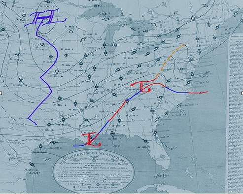
MAP 3
On the morning of the 6th, note the massive surface storm system covering pretty much the eastern half of the country. This is also reminscent of the our January 26-28th, 1978 storm in its deepening intensity (though the ’78 storm bottom-out deeper), estimated upper air pattern and extent of coverage. Note the area of heavy snow and blizzard counditions over the Eastern Great Lakes with sky obscured in heavy, driving snow (shaded round circles, not black) as suface troughing extends northward up into Lake Huron as the surface low backs toward the Lakes Region. This heavy snow scene replicates that of our 1974 storm with its "conveyor-belt " analogy of moisture drawn from the Atlantic westward into the Eastern Great Lakes . The heaviest snow fell across extreme Southern Ontario, extreme Southeast Lower Michigan and extreme Northwest Ohio with the ’74 storm also and note how that same area is shaded here in the 1886 storm. An estmated postion of the 500 MB low is included (most likely very close, if not indentical to the1978 and 1974 storm) somewhere in the Upper Ohio Valley (Kentucky northward into the Eastern Great Lakes). Note, the high pressure system has been squeezed northwestward into a "horseshoe" shape pattern, also reflective of the 1974 storm.
April 6th 1886, 7AM EST


