A large slow moving low pressure system dropped over a foot of snow over parts of Southeast Michigan that began on Tuesday night (March 6th) and lasted through Thursday night (March 8th). Snow started moving in across the area Tuesday night and kept producing light snow showers throughout the day on Wednesday and into Thursday as it slowly meandered across lower Michigan. Winter Weather Advisories were in effect for most locations on Wednesday, along with a Winter Storm Warning for Livingston and Oakland where just over 7 inches fell in a short period of time Tuesday night. Temperatures had been above freezing the past week, which meant that ground temperatures warmed and while some snow did accumulate on the roadways Wednesday morning, most roadways (those that were well-traveled) were just wet by the late morning. Winter Weather Advisories and Winter Storm Warnings were again issued for another round of snowfall on Thursday that accumulated up to an additional 8 inches of snowfall across the Thumb region. This low pressure system brought narrow banding of heavier snow showers, much like the last snowfall on March 1st.
Snowfall Map
.png) |
| Tuesday Night through Thursday Night Snowfall Amounts (March 6 - March 8, 2018) |
Radar:
 |
 |
 |
| 6:50 PM 3/6/18 (Tuesday Evening) - 2:20 PM 3/7/18 (Wednesday Afternoon) Radar Loop | 2:50 PM 3/7/18 (Wednesday Afternoon) - 6:20 AM 3/8/18 (Thursday Morning) Radar Loop | 6:50 AM 3/8/18 (Thursday Morning) - 10:20 PM 3/8/18 (Thursday Night) Radar Loop |
Storm Reports
The first set of reports includes storm totals from Tuesday through early Wednesday:

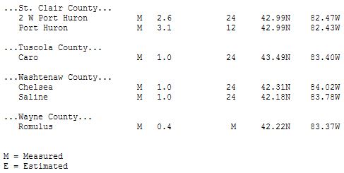
The second set of reports includes storm totals for the entire event from Tuesday through early Friday morning:

Note: This is a general overview of the event. More local storm reports can be found by visiting the link below. We appreciate all the reports we receive, even if a report is not listed, we still keep track of all the reports we get.
Preliminary snowfall reports can be found here.
All storm reports from the event can be found on the Iowa Environmental Mesonet (IEM) here.
 |
Media use of NWS Web News Stories is encouraged! Please acknowledge the NWS as the source of any news information accessed from this site. |
|

