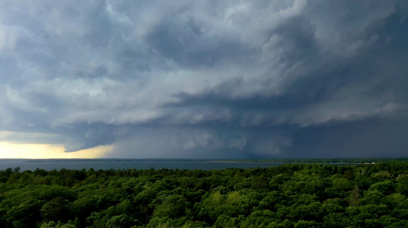
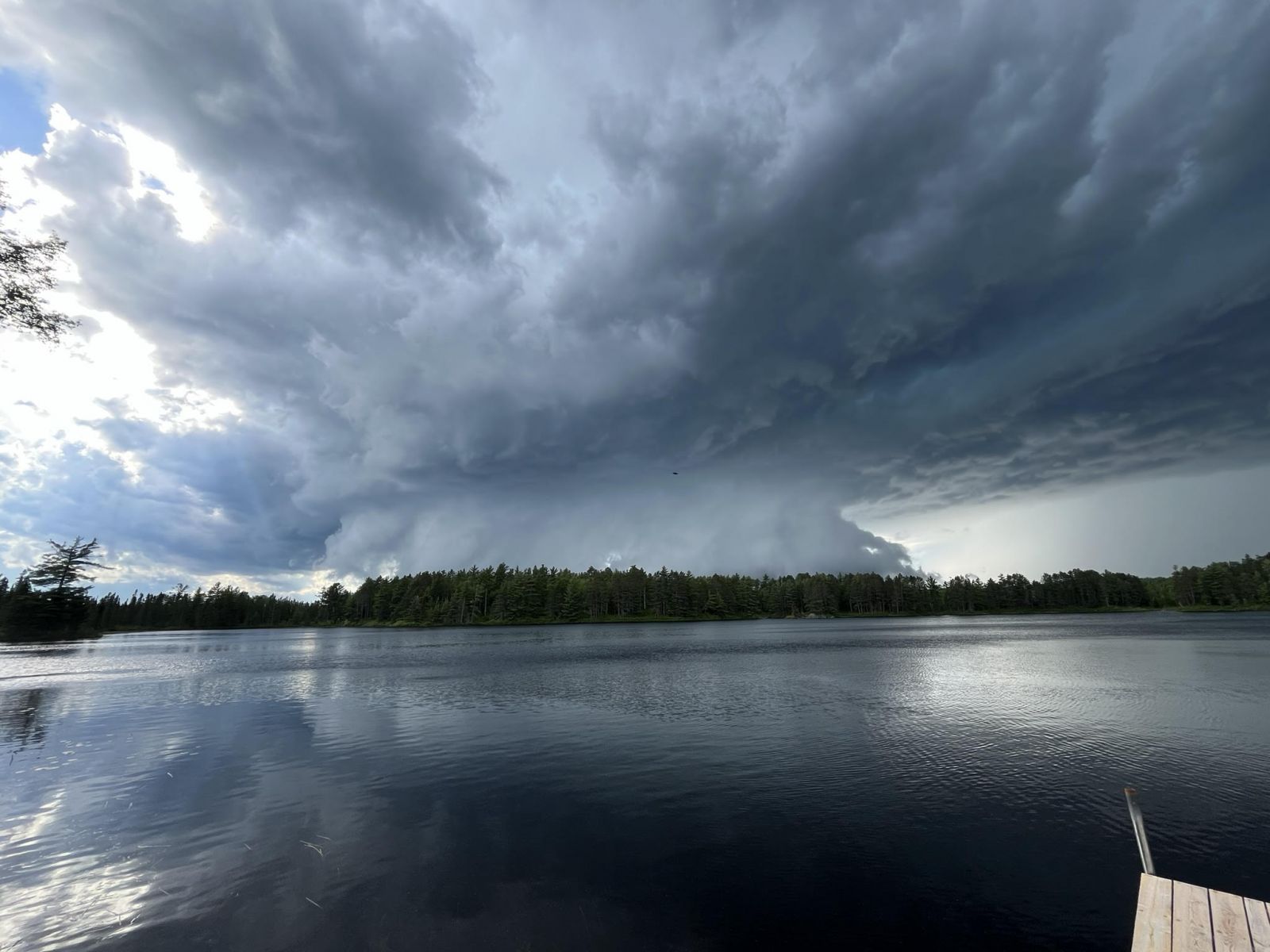
Tornado warned storm near Crosslake, MN. This thunderstorm would go on to produce six tornadoes, 2 EF-2, 2 EF-1, and 2 EF-0. Photo courtesy of Jason Bednar.
Overview
|
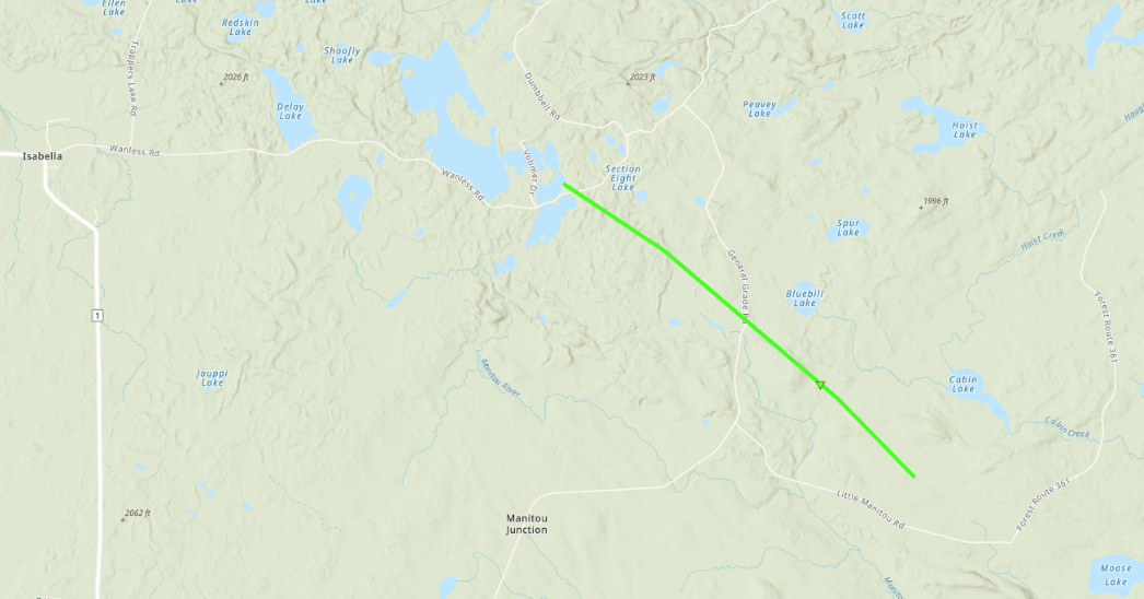
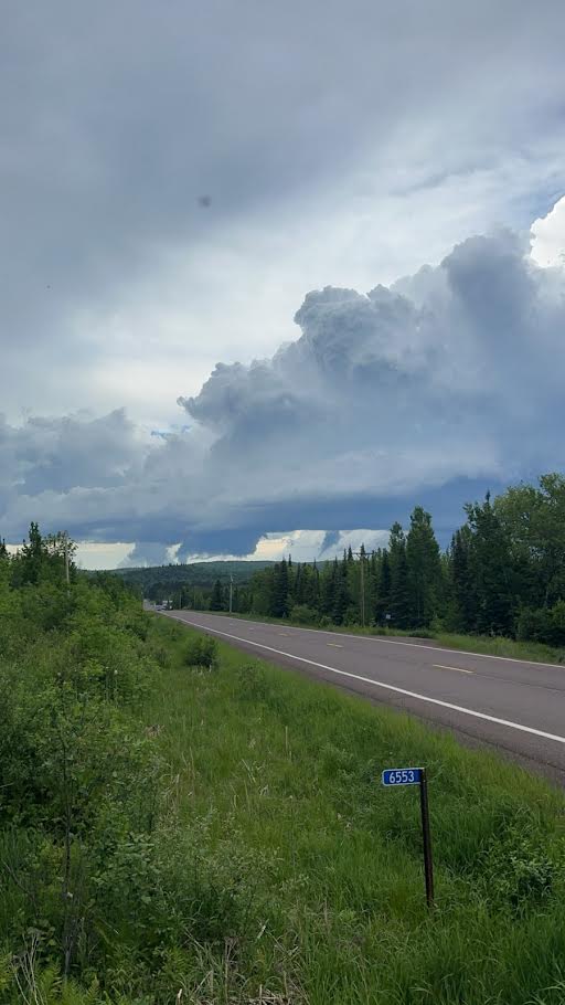
Numerous severe thunderstorms moved across north-central and northeast Minnesota on the evening of Wednesday, June 12, 2024, producing large hail to the size of baseballs, isolated thunderstorm wind damage, and several tornadoes. Two distinct supercellular storms produced five tornadoes (rated EF-0 and EF-2) Another earlier storm that was the earliest supercell of the severe storm event, initially developed over Koochiching County and into far northern Saint Louis County where it split. The right split headed for Ely, MN, and continued on a southeast path towards Tofte. The supercell was rotating throughout its lifetime, with a report of a funnel cloud when the storm was east of Ely. The storm briefly weakened for a time, then strengthened and produced strong mid-level rotation northeast of Isabella. This storm then produced an EF-1 tornado starting near Tanner Lake to the northeast of Isabella that tracked southeast for just over four miles, creating a swath of numerous uprooted and snapped trees. This tornado rating was determined based on satellite imagery, and NWS Duluth is coordinating to learn more about any air or ground surveyed damage from our partners at the Superior National Forest which may result in a future revision in the tornado rating.
This information is preliminary in nature and will likely be revised as we continue to review additional reports, images, and videos. NWS Duluth sincerely appreciates the coordination with our state and local partners including Emergency Management and |
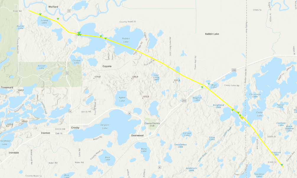
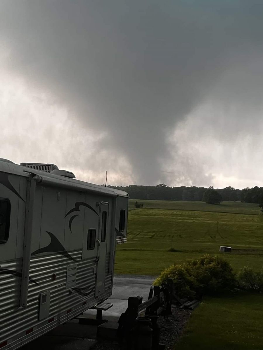 A view of the Wolford to Rabbit Lake to Cedar Lake to Prescott Lake Tornado from near Highway 210 and County Road 32 west of Aitkin. This view is looking west between Rabbit Lake and Cedar Lake. Photo courtesy Adam Schneider. |
Tornadoes:
This storm developed around 3:45 PM CDT in northwest Minnesota in southeast Norman County, west of Wabun. The storm tracked generally east-southeastward and dissipated around 10 PM CDT in southeast Douglas County, WI, near Wascott after traveling a distance of approximately 230 miles.
|
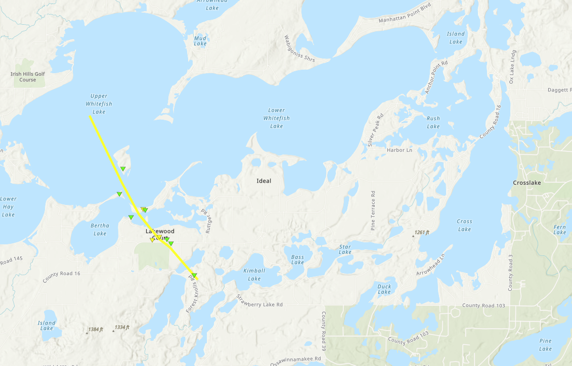
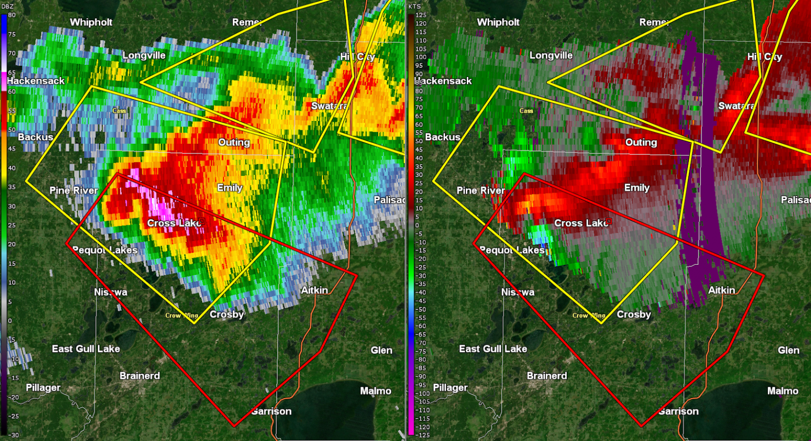
Tornado - Whitefish Lake/Clamshell Lake/West of Crosslake, MN
|
||||||||||||||||
|
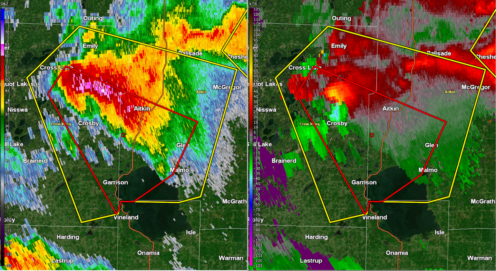
Tornado - Wolford to Rabbit Lake to Cedar Lake to Prescott Lake Tornado
|
||||||||||||||||
|
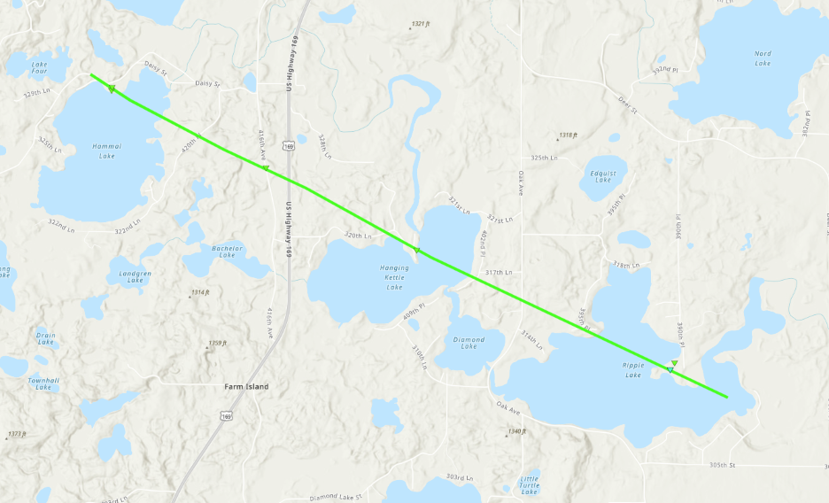
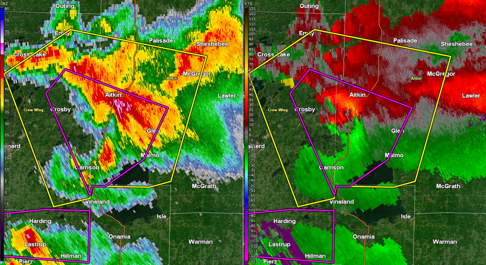
Tornado - Hammal Lake to Hanging Kettle Lake to Ripple Lake Tornado
|
||||||||||||||||
|
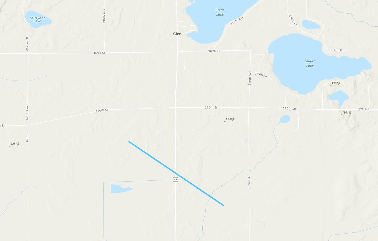
Tornado - Near Glen, MN
|
||||||||||||||||
This storm developed around 6 PM between Hill City and McGregor in Aitkin County, MN. The storm moved generally east-southeastward and dissipated near Solon Springs in Douglas County, WI, after traveling about 90 miles.
|
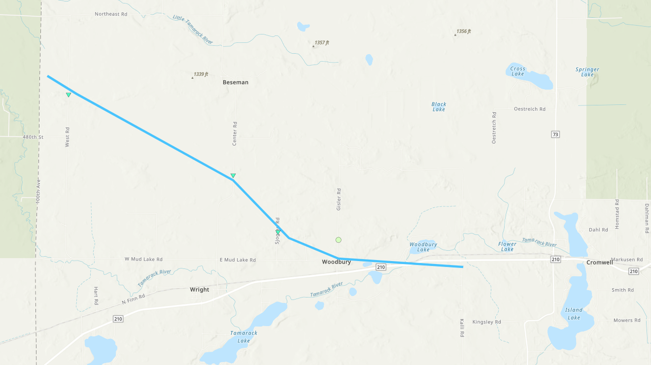
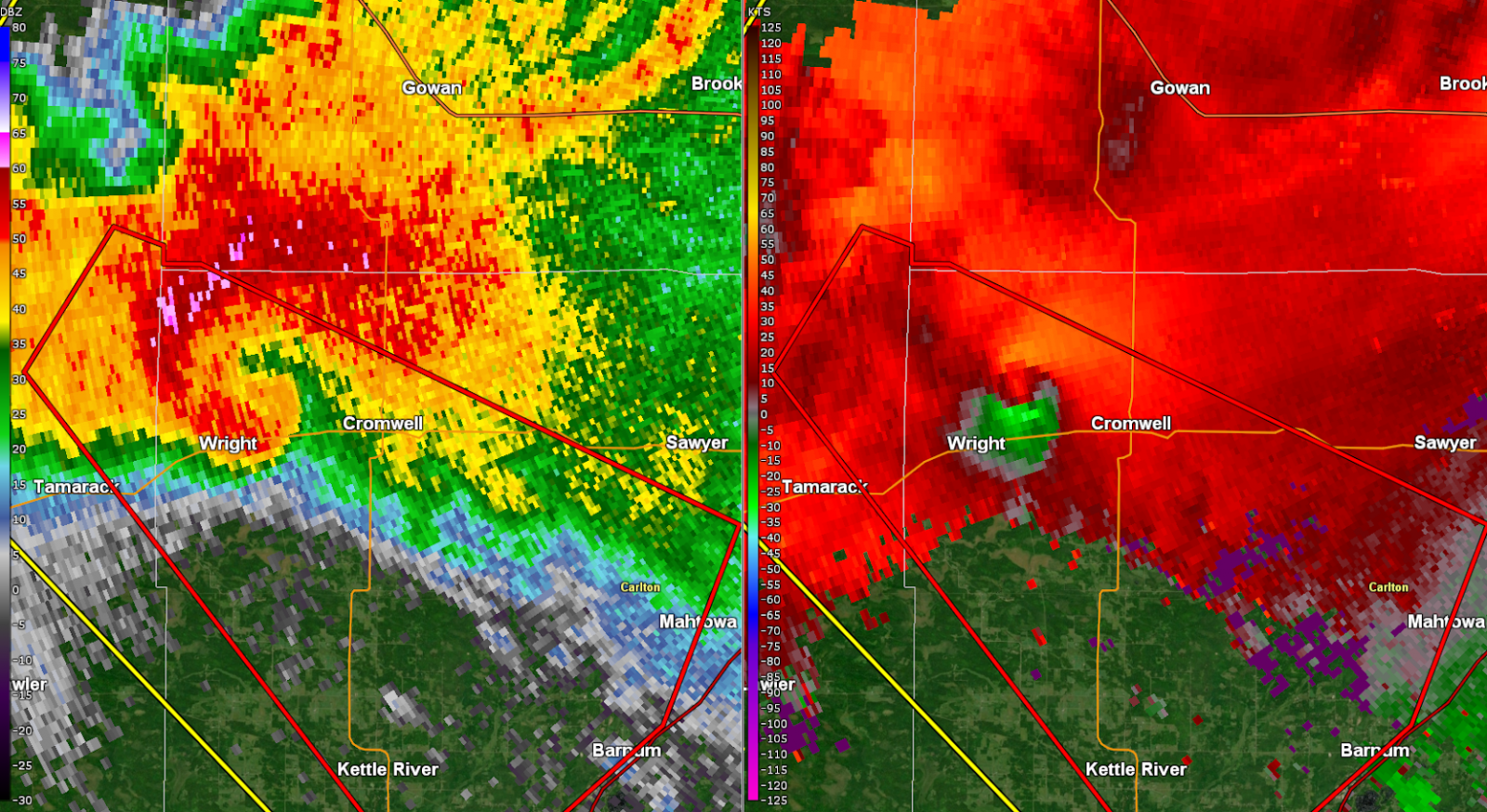
Tornado - Wright/Cromwell, MN
|
||||||||||||||||
|
Tornado - Tanner Lake Tornado
|
||||||||||||||||
The Enhanced Fujita (EF) Scale classifies tornadoes into the following categories:
| EF0 Weak 65-85 mph |
EF1 Moderate 86-110 mph |
EF2 Significant 111-135 mph |
EF3 Severe 136-165 mph |
EF4 Extreme 166-200 mph |
EF5 Catastrophic 200+ mph |
 |
|||||
Wind & Hail:
Wind
Some isolated wind damage occurred in the storms that produced the largest hail, leading to a couple trees down and a backyard playset flipped. The worst wind damage occurred within tornadoes over Crow Wing, Aitkin, and Carlton Counties.
Hail
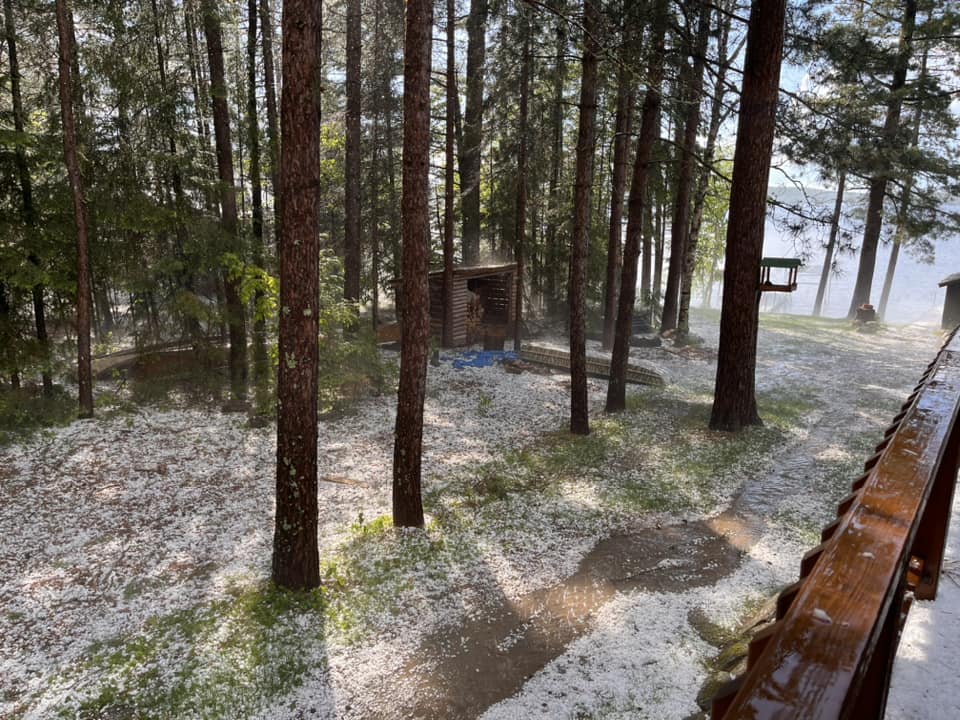
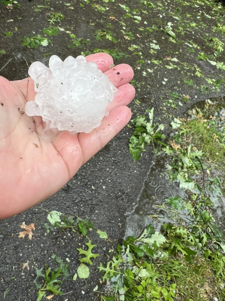
Hail the size of a quarter to nearly a baseball in size was reported across mainly northeast Minnesota from the late afternoon hours to early overnight hours of Wednesday, June 12, 2024 as discrete supercells moved from west-northwest to east-southeast. Hail damaged cars, windows, gutters, roofs, and outdoor furniture.
 |
 |
 |
 |
|
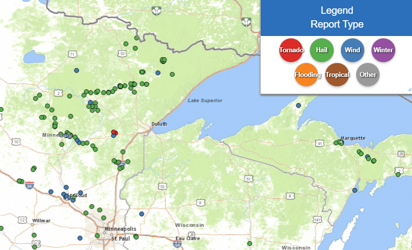
Local Storm Reports of mainly hail reports in the Northland from the late afternoon to early overnight hours of Wednesday June 12, 2024 (NWS photo) |
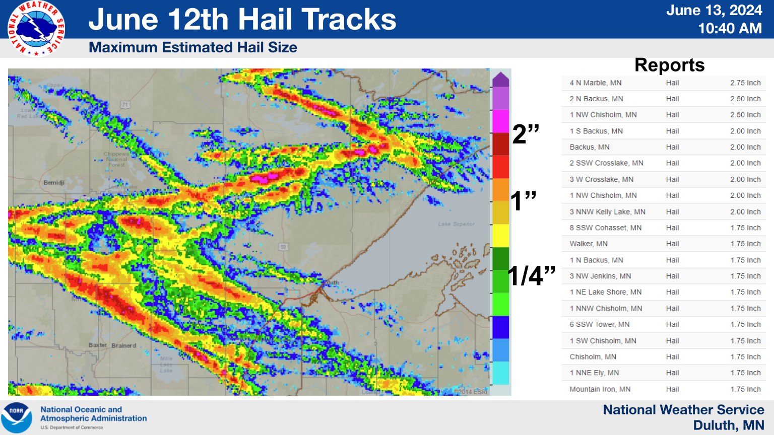
Maximum Radar Estimated Hail (MESH) tracks from supercells which dropped anywhere from hail the size of a quarter to nearly a baseball in the late afternoon to early overnight hours of Wednesday, June 12, 2024. (NWS photo) |
Hail 1 Mile South Of Backus, MN. (Kelsey Scherf photo) |
Hail in Finlayson, MN. (Mike Waite photo) |
Photos
 |
 |
 |
 |
|
Tornado damage between Upper Whitefish and Bertha Lakes. (NWS Duluth Storm Survey) |
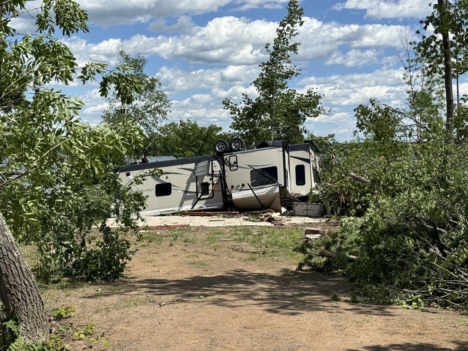
RV flipped upside down near Rabbit Lake, north of Crosby, MN, by a tornado. (NWS Duluth Storm Survey) |
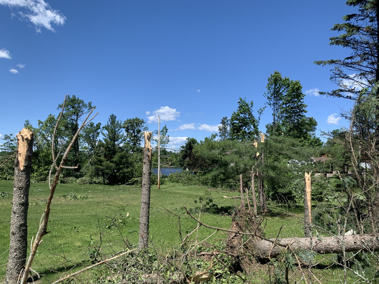
Numerous trees snapped near Cedar Lake, southwest of Aitkin, MN, by a tornado. (NWS Duluth Storm Survey) |
Hail coats the ground near Ely. (Zona Lewis Simonson photo)
|
 |
 |
 |
 |
|
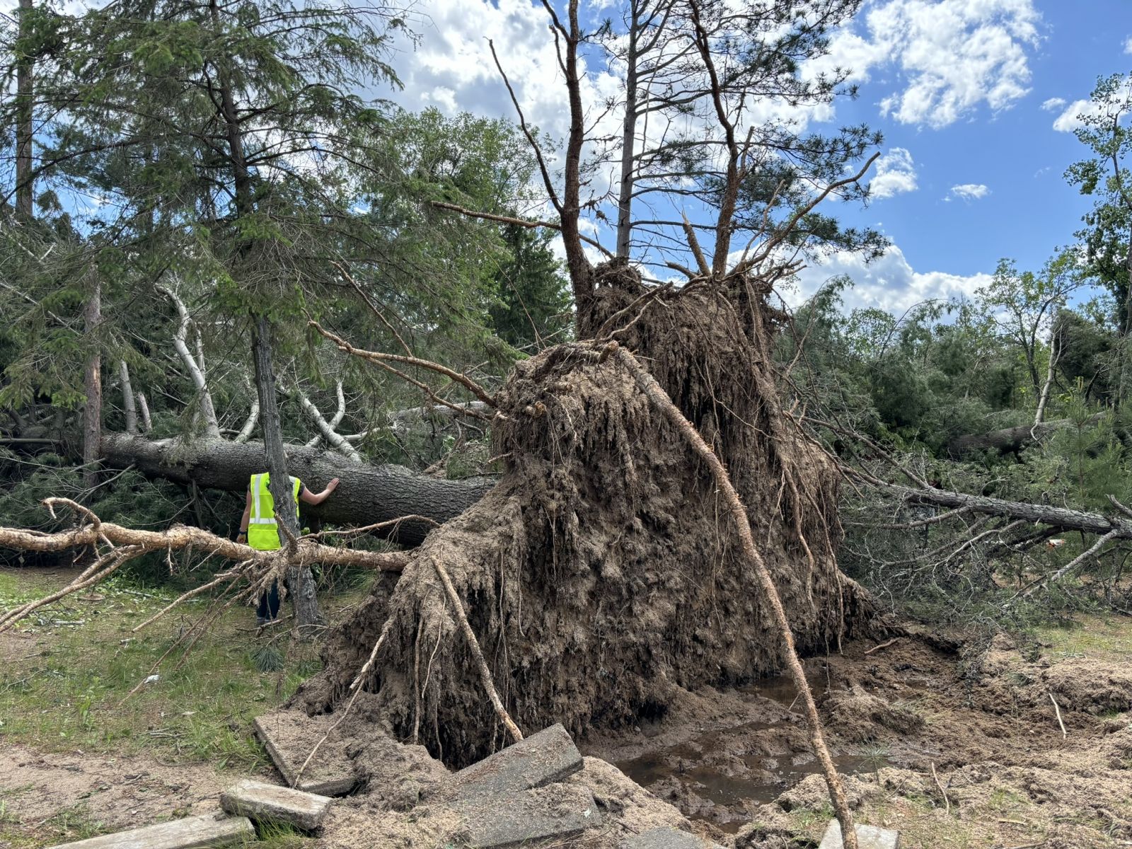
Old growth pine uprooted near Upper Whitefish Lake by the tornado. (NWS Duluth Storm Survey) |
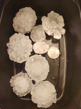
Golf ball sized hail near Hammal Lake in Aitkin County. (Karin Ellingsworth Borowicz photo) |
2" hail at the Crosslake campground. (Jenni Tuchek Matyas photo) |
Wall cloud near Finland, MN. (Amber Viney photo) |
 |
 |
 |
 |
|
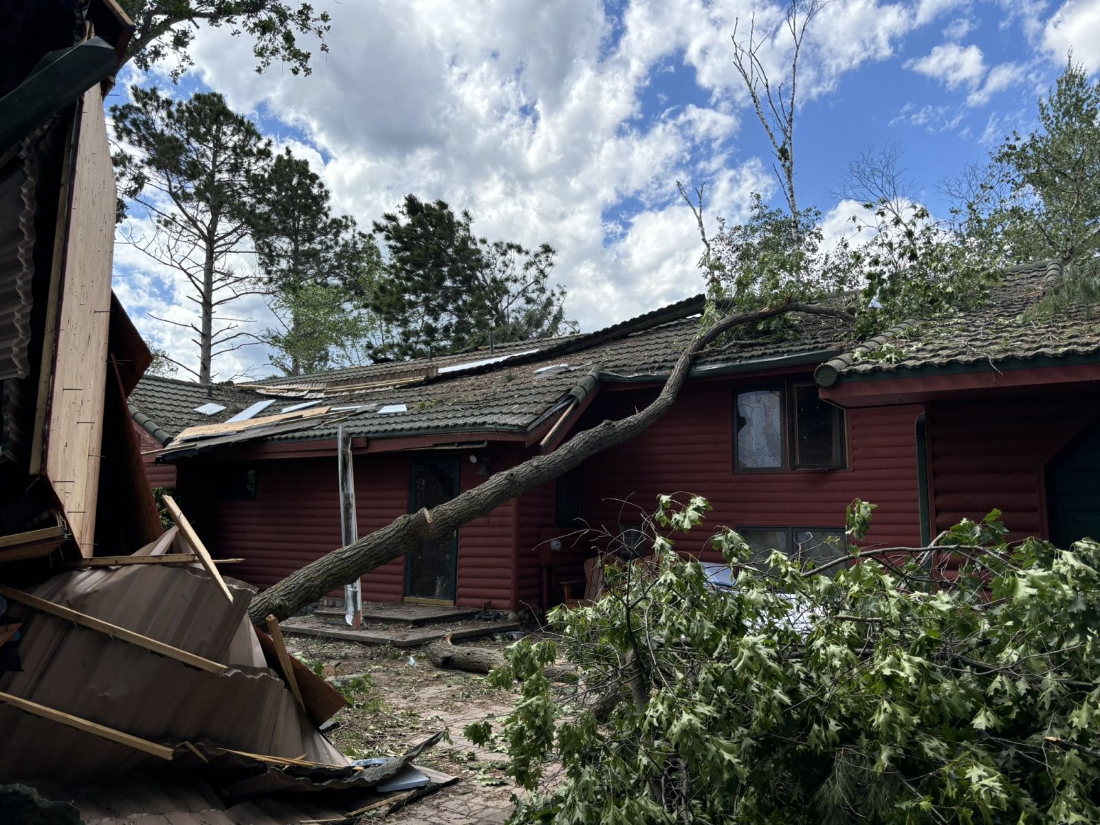
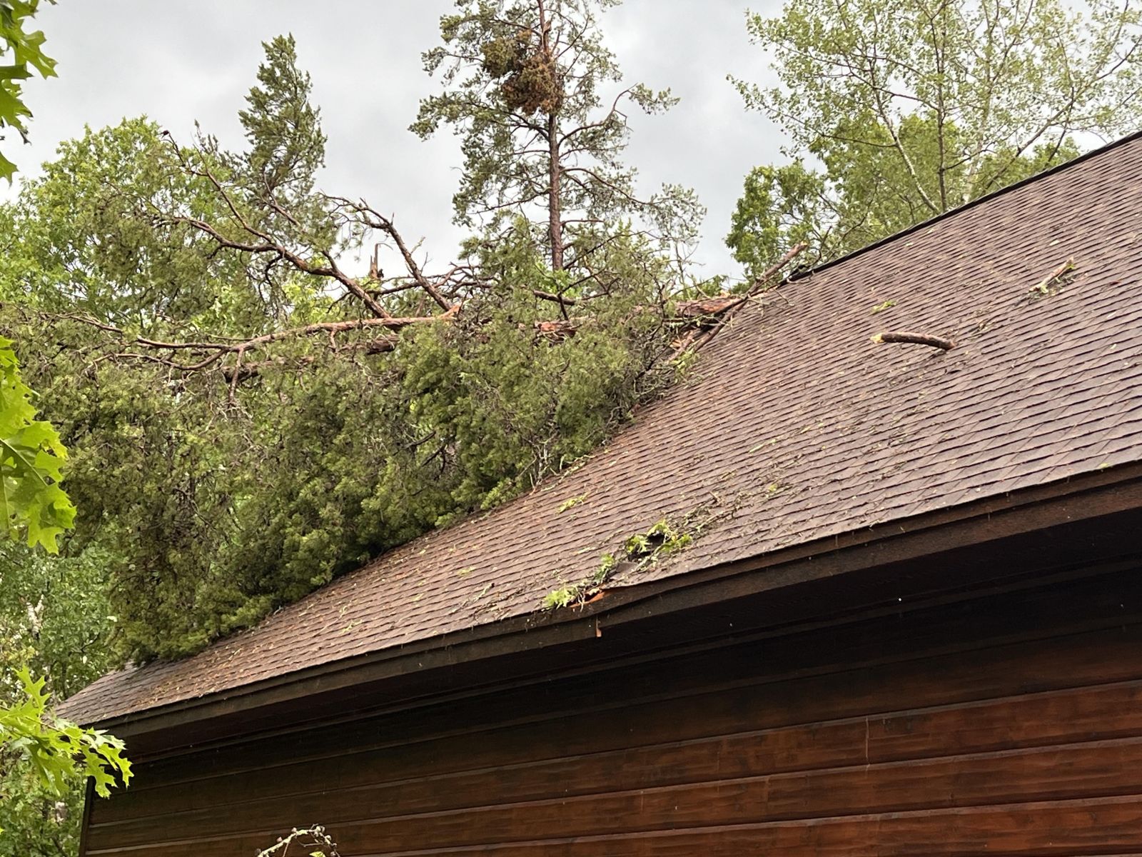
Broken trees and branches puncturing the roof of a home near Upper Whitefish Lake. (Colin Steadland photo) |
Broken trees and roof damage near Upper Whitefish Lake. (Crow Wing County drone photo) |
Tennis ball sized hail in Chisholm. (Photo courtesy Kara Niemi McLaughlin) |
Wall Cloud near Isabella. (Steve Wilson photo) |
Radar
Radar imagery of a tornado moving through Crow Wing and Aitkin Counties and one in Carton County
 |
 |
 |
 |
|
5:17 PM CT - A confirmed tornado moved through Crow Wing County in the early evening hours of Wednesday, June 12th as shown by the 0.2 degree KDLH WSR-88D reflectivity and storm relative velocity imagery shown here. (NWS Photo) |
5:45 PM CT - A confirmed tornado moved through Crow Wing County in the early evening hours of Wednesday, June 12th as shown by the 0.2 degree KDLH WSR-88D reflectivity and storm relative velocity imagery shown here. (NWS Photo) |
6:04 PM CT - A confirmed tornado moved from Crow Wing County into Aitkin County in the early evening hours of Wednesday, June 12th as shown by the 0.2 degree KDLH WSR-88D reflectivity and storm relative velocity imagery shown here. (NWS Photo) |
A confirmed tornado moved through Carlton County in the evening hours of Wednesday, June 12th as shown by the 0.2 degree KDLH WSR-88D reflectivity and storm relative velocity imagery shown here at 5:48 PM CT. (NWS Photo) |
Storm Reports
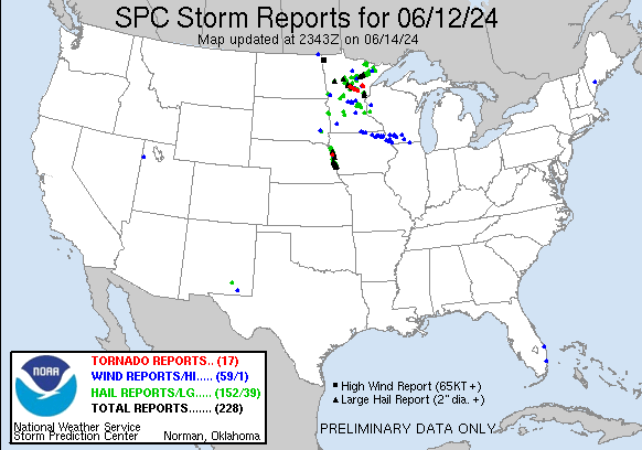
Click the image above for Storm Reports from around the country.
View a Local Storm Reports map here: https://www.mesonet.agron.iastate.edu/lsr/#DLH/202406120500/202406130500/011010.
Public Information Statement
National Weather Service Duluth MN
1243 PM CDT Thu Jun 13 2024

...JUNE 12 HAIL REPORTS...

Location                     Size      Time/Date       Provider
4 N Marble                   2.75 in   0615 PM 06/12   Public
Chisholm                     2.50 in   0550 PM 06/12   Public
1 NW Chisholm                2.50 in   0553 PM 06/12   Trained Spotter
Finlayson                    2.50 in   0853 PM 06/12   Storm Chaser
2 NNE Backus                 2.50 in   0558 PM 06/12   Trained Spotter
2 ENE Friesland              2.25 in   0850 PM 06/12   Public
Chisholm                     2.00 in   0545 PM 06/12   Public
3 NNW Kelly Lake             2.00 in   0546 PM 06/12   Public
Chisholm                     2.00 in   0550 PM 06/12   Public
1 NW Chisholm                2.00 in   0550 PM 06/12   Public
2 SSW Crosslake              2.00 in   0617 PM 06/12   Public
3 W Crosslake                2.00 in   0619 PM 06/12   Public
Backus                       2.00 in   0546 PM 06/12   Public
1 S Backus                   2.00 in   0547 PM 06/12   Trained Spotter
1 NNE Ely                    1.75 in   0512 PM 06/12   Public
Chisholm                     1.75 in   0545 PM 06/12   Public
1 SW Chisholm                1.75 in   0554 PM 06/12   Trained Spotter
1 NNW Chisholm               1.75 in   0606 PM 06/12   Trained Spotter
Mountain Iron                1.75 in   0609 PM 06/12   Public
6 SSW Tower                  1.75 in   0710 PM 06/12   Trained Spotter
3 W Finlayson                1.75 in   0839 PM 06/12   NWS Employee
1 SSE Sandstone              1.75 in   0855 PM 06/12   Public
7 NNW Taconite               1.75 in   0520 PM 06/12   Public
8 SSW Cohasset               1.75 in   0544 PM 06/12   Public
Walker                       1.75 in   0540 PM 06/12   Public
1 N Backus                   1.75 in   0553 PM 06/12   Trained Spotter
3 NW Jenkins                 1.75 in   0600 PM 06/12   Public
1 NE Lake Shore              1.75 in   0631 PM 06/12   Public
5 W Aitkin                   1.75 in   0705 PM 06/12   Public
1 S Buyck                    1.50 in   0418 PM 06/12   Public
2 N Crane Lake               1.50 in   0420 PM 06/12   Public
1 E Ely                      1.50 in   0520 PM 06/12   Trained Spotter
1 SSW Winton                 1.50 in   0526 PM 06/12   Trained Spotter
Buhl                         1.50 in   0556 PM 06/12   Public
1 W Sandstone                1.50 in   0857 PM 06/12   Public
12 WNW Isabella              1.50 in   0559 PM 06/12   Cocorahs
Deer River                   1.50 in   0509 PM 06/12   Law Enforcement
Nashwauk                     1.50 in   0128 AM 06/13   Public
2 SSW Swanburg               1.50 in   0610 PM 06/12   Public
3 SW Crosslake               1.50 in   0623 PM 06/12   Trained Spotter
1 SW Crosslake               1.50 in   0630 PM 06/12   Public
3 ESE Bena                   1.50 in   0446 PM 06/12   Trained Spotter
1 SE Inguadona               1.50 in   0509 PM 06/12   Trained Spotter
Chisholm                     1.25 in   0549 PM 06/12   Public
Biwabik                      1.25 in   0613 PM 06/12   Public
5 WNW Finlayson              1.25 in   0842 PM 06/12   Public
7 NNW Bovey                  1.25 in   0531 PM 06/12   Trained Spotter
6 SSW Grand Rapids           1.25 in   0540 PM 06/12   Trained Spotter
7 NNW Bovey                  1.25 in   0555 PM 06/12   Trained Spotter
3 E Jenkins                  1.25 in   0622 PM 06/12   Public
2 NNE Cuyuna                 1.25 in   0641 PM 06/12   Cocorahs
Aitkin                       1.25 in   0706 PM 06/12   Public
7 NE Cusson                  1.00 in   0408 PM 06/12   Public
2 N Ely                      1.00 in   0510 PM 06/12   Emergency Mngr
Chisholm                     1.00 in   0554 PM 06/12   Public
3 W Leonidas                 1.00 in   0600 PM 06/12   Cocorahs
2 ESE Mountain Iron          1.00 in   0604 PM 06/12   Public
Mountain Iron                1.00 in   0604 PM 06/12   Public
2 W Virginia                 1.00 in   0605 PM 06/12   Public
1 WNW Virginia               1.00 in   0613 PM 06/12   Public
Virginia                     1.00 in   0618 PM 06/12   Public
3 ESE Iron Junction          1.00 in   0639 PM 06/12   Cocorahs
6 SW Tower                   1.00 in   0708 PM 06/12   Public
5 NE Deer River              1.00 in   0513 PM 06/12   Public
8 N Cohasset                 1.00 in   0515 PM 06/12   Public
6 N Hill City                1.00 in   0535 PM 06/12   Public
8 N Cohasset                 1.00 in   0602 PM 06/12   Public
4 S Rossburg                 1.00 in   0720 PM 06/12   Trained Spotter
Glen                         1.00 in   0805 PM 06/12   Public
Nashwauk                     0.88 in   0128 AM 06/13   Public
1 S Aurora                   0.75 in   0614 PM 06/12   Public
1 SSE Aurora                 0.75 in   0623 PM 06/12   Public
6 SW Tower                   0.75 in   0707 PM 06/12   Public
4 SW Denham                  0.75 in   0810 PM 06/12   Public
4 ENE Askov                  0.75 in   0833 PM 06/12   Public
1 SSW La Prairie             0.75 in   0547 PM 06/12   Public
2 NNE Hackensack             0.70 in   0602 PM 06/12   Trained Spotter
Winton                       0.50 in   0515 PM 06/12   Public
1 SW Virginia                0.50 in   0604 PM 06/12   Public
Biwabik                      0.50 in   0625 PM 06/12   Public
5 S La Prairie               0.50 in   0543 PM 06/12   Public
8 SSW Blackberry             0.50 in   0558 PM 06/12   Public
Sturgeon Lake                0.25 in   0820 PM 06/12   Public
Keewatin                     0.25 in   0128 AM 06/13   Law Enforcement

Observations are collected from a variety of sources with varying
equipment and exposures. We thank all volunteer weather observers
for their dedication. Not all data listed are considered official.

$$
Environment
 SPC AC 121631

   Day 1 Convective Outlook
   NWS Storm Prediction Center Norman OK
   1131 AM CDT Wed Jun 12 2024

   Valid 121630Z - 131200Z

   ...THERE IS AN ENHANCED RISK OF SEVERE THUNDERSTORMS ACROSS PARTS OF
   NORTHERN MINNESOTA AND ADJACENT NORTHWESTERN WISCONSIN AND WESTERN
   LAKE SUPERIOR...

   ...SUMMARY...
   Scattered severe thunderstorms capable of very large hail, damaging
   wind gusts, and a few tornadoes will be possible across parts of the
   Upper Midwest late afternoon and early evening.

   ...Upper Mississippi Valley/Upper Midwest...
   Bands/clusters of convection are ongoing at this time, from the
   Minnesota Arrowhead southward across northern Wisconsin, and
   southwestward across southern Minnesota into the Mid Missouri Valley
   region.  This convection continues moving eastward, toward a less
   unstable airmass, which should temper severe risk over the next few
   hours.  Greatest potential for a couple of marginally severe storms
   appears to exist over southwestern Minnesota and adjacent portions
   of southeastern South Dakota and northwestern Iowa, where the
   greatest instability resides.

   Greater severe risk is forecast to evolve later this afternoon,
   north of the ongoing storms.  Here, daytime heating ahead of an
   advancing cold front (associated with a low-amplitude short-wave
   trough embedded in fast westerly flow aloft, and moving eastward
   along the international border) will result in moderate to strong
   instability (2500 to 3500 J/kg mixed-layer CAPE) within the
   pre-frontal warm sector.

   Weakly veering but strengthening flow with height across the region
   will provide favorable shear for organized/rotating storms.  Initial
   convection -- expected to initiate in the 12/20Z to 12/21Z time
   frame -- should quickly organize/become supercellular, with very
   large hail likely to be the initial/primary severe risk.  A couple
   of tornadoes will also be possible, though veered low-level flow
   should temper overall tornado risk.  With time, storms are expected
   to cluster/grow upscale, with small-scale bowing expected, which
   should yield a gradual increase in damaging-wind potential.  Storms
   will spread rather quickly eastward/southeastward with time, with
   some severe risk likely to linger through the evening before
   gradually diminishing overnight.

   ..Goss/Moore.. 06/12/2024
 |
 |
 |
|
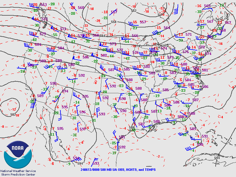
Figure 1: 500 mb heights analysis from the Storm Prediction Center showing a strong mid-level zonal jet over the central United States. (NWS Photo) |
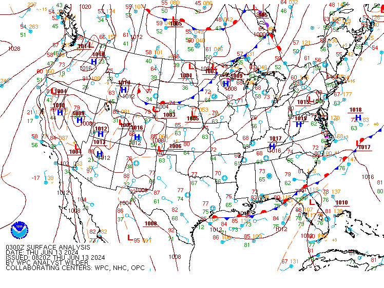
Figure 2: Surface analysis from the Storm Prediction Center showing a low pressure system dropping southward from Canada into northern Minnesota late in the day on June 12, 2024. (NWS Photo) |
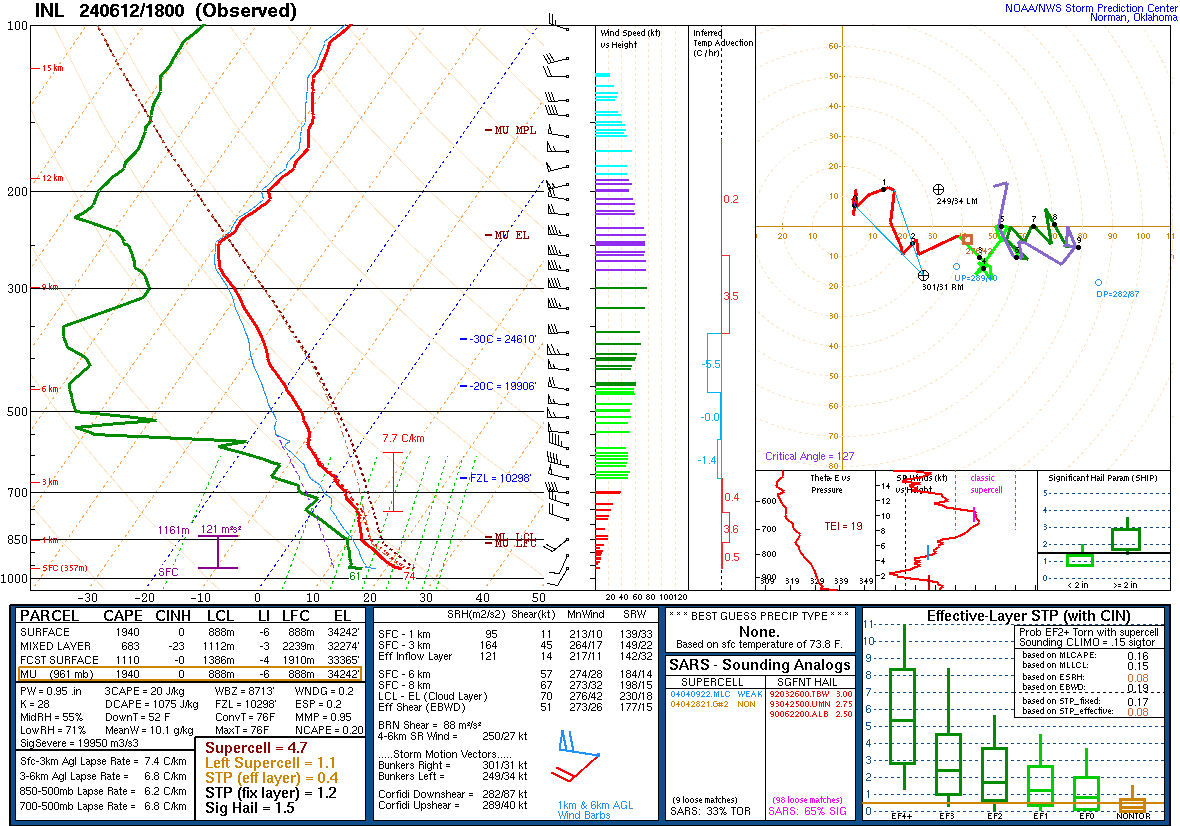
Figure 3: Special 18Z Sounding from International Falls, MN ahead of convection that formed first in the Minnesota Borderlands first about three hours later. (NWS Photo) |
 |
 |
 |
|
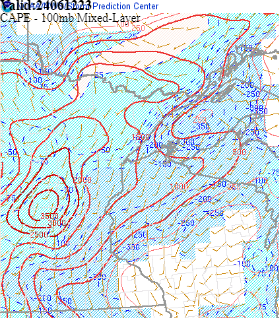
Figure 4: Mixed Layer CAPE built into the Upper Midwest by the late afternoon on June 12 to aid in storm development as seen by the 12/21Z RAP Mixed Layer CAPE analysis. (NWS SPC Photo) |
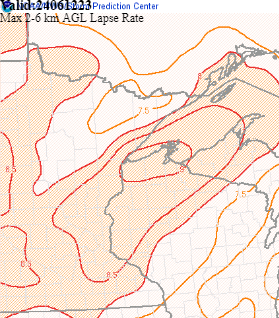
Figure 5: Steep mid-level lapse rates supported severe thunderstorms to move across northern Minnesota through 02Z on Thursday, June 13 as seen by the 12/21Z RAP Max 2-6km lapse rates analysis. (NWS SPC Photo) |
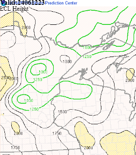
Figure 6: LCL heights of 1000 meters, as seen in this 12/21Z RAP LCL Heights analysis, supported lower wall clouds by early evening on the 12th with at least several tornadoes observed in the greater Brainerd Lakes region. (NWS SPC Photo) |
SPC Day 1 Outlooks
 |
 |
 |
 |
|
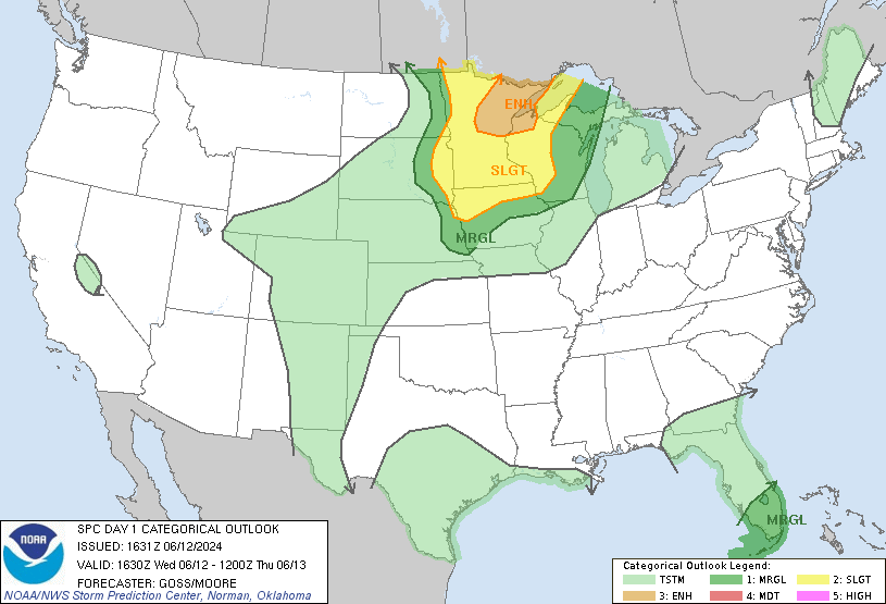
1630z Day 1 Categorical Outlook (NWS SPC Photo) |
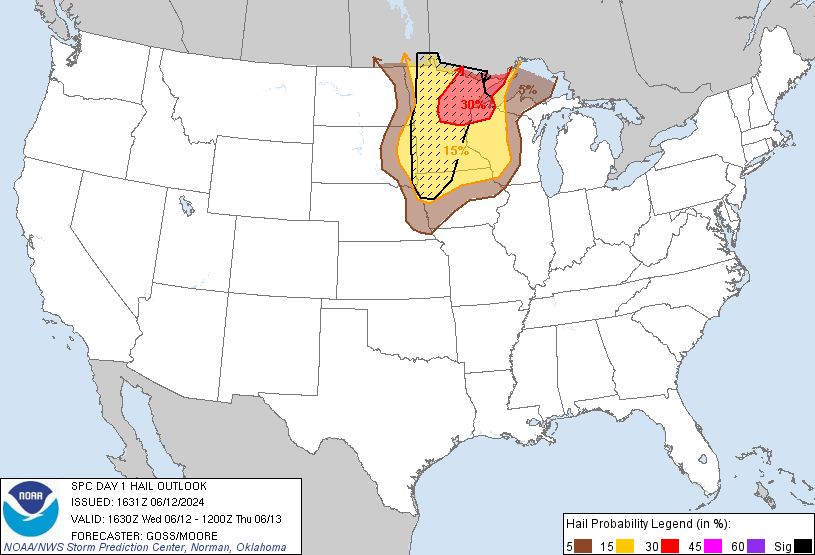
1630z Day 1 Hail Outlook (NWS SPC Photo) |
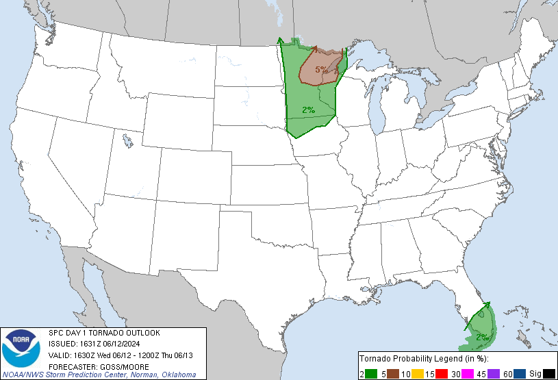
1630z Day 1 Tornado Outlook (NWS SPC Photo) |
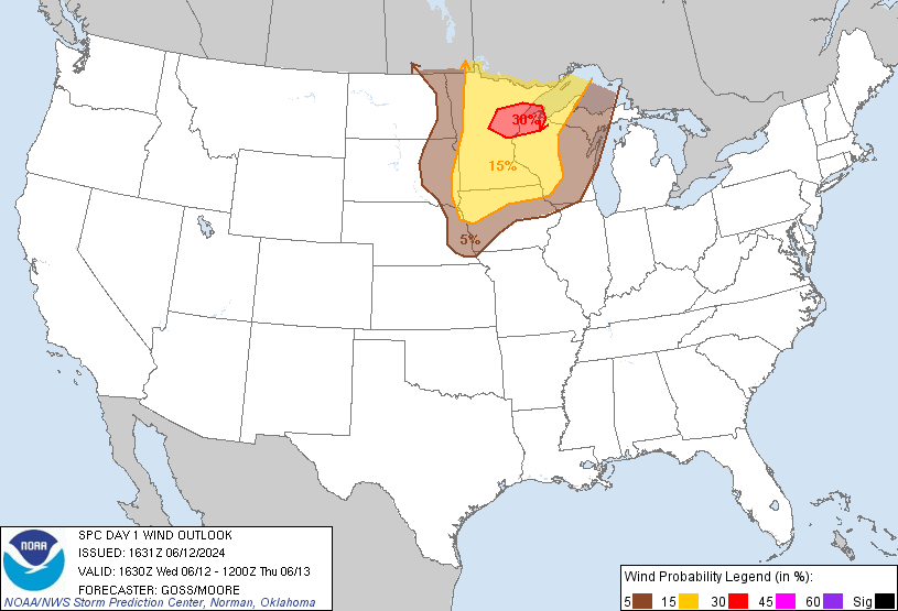
1630z Day 1 Wind Outlook (NWS SPC Photo) |
 |
Media use of NWS Web News Stories is encouraged! Please acknowledge the NWS as the source of any news information accessed from this site. |
|