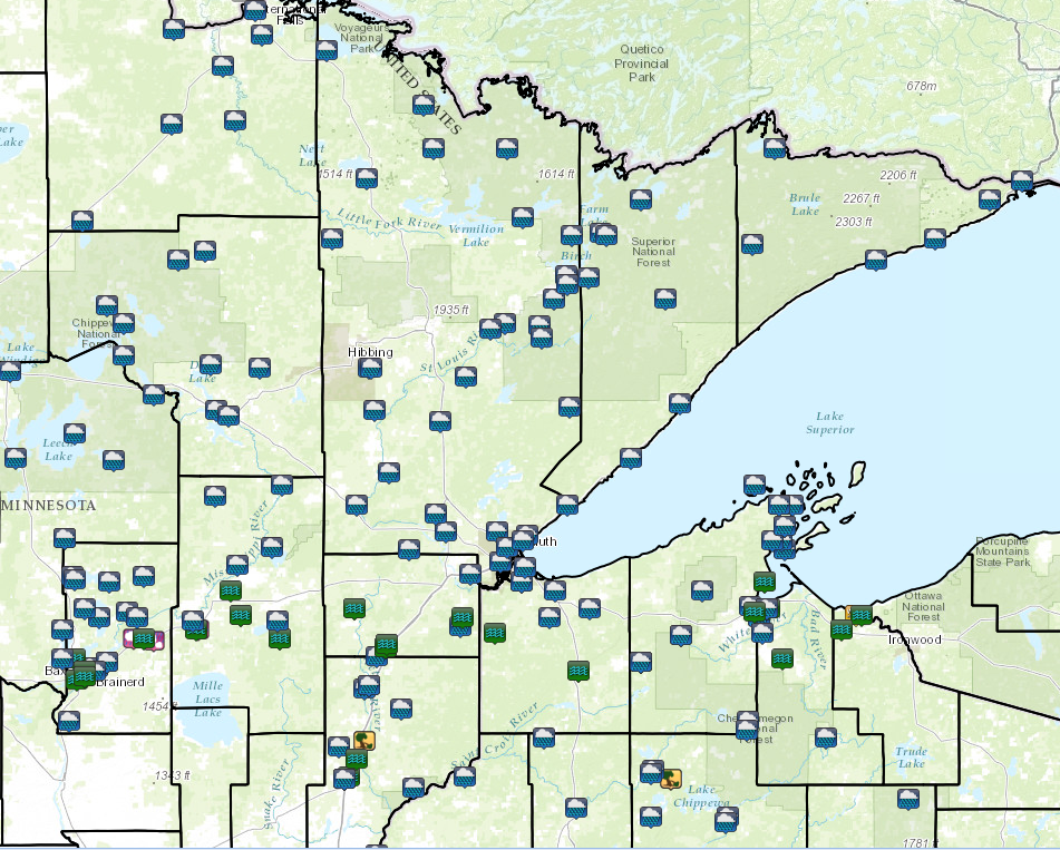
Overview
|
Multiple rounds of thunderstorms - some storms strong to severe - impacted much of east-central to northeast Minnesota and northwest Wisconsin Monday, July 11, 2016, with the worst of the heavy rain and flash flooding occurring in the evening hours. This resulted in significant flooding across parts of the region and many road closures, including the closure of Interstate 35 for a period of time. The flooding was so severe in northwestern Wisconsin that no travel was advised over much of the area due to washouts and water over roads. Rainfall amounts were 4 to 10 inches in a 24 hour period, but much of it falling in an 8 hour period. a swath of 8 to 10 inches of rain extended from northern Crow Wing County, MN, through Aitkin and Pine counties then across northern Wisconsin from Danbury to Hurley. The Saxon Harbor area of northern Iron County was hit with major flooding from the many creeks, rivers and streams that flow into it. Also, a bow echo type storm moved across northern Iron County, WI, and caused tremendous amounts of damage at Saxon Harbor, WI. Numerous vessels were affected by the severe downburst winds. There were 23 beached vessels, 6 vessels became adrift and some were overturned. There was also substantial wind damage at the campground. Below, left, is a radar screen shot at about the time of the storm hitting Saxon Harbor, about 7:45 pm. And a 24 hour radar loop from about 2 am on July 11th to 6 am on the 12th. Click each thumbnail for a larger view.
|
|
Flooding
Flash Flooding occurred across parts of east-central Minnesota into northwest Wisconsin. In addition, the heavy rain rates resulted in flooding to some area rivers.
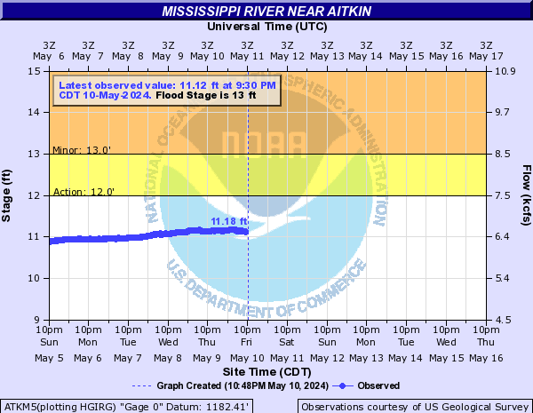
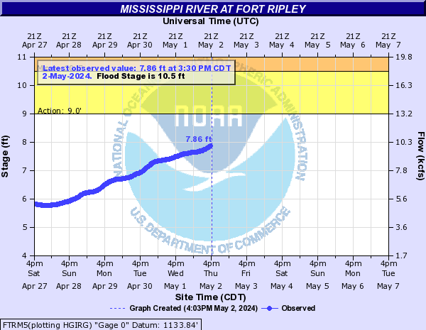
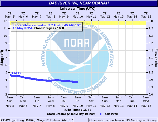
Hydrographs
 |
 |
 |
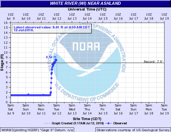 |
| Mississippi River Near Aitkin | Mississippi River at Fort Ripley | Whittlesey Creek near Ashland | White River near Ashland |
 |
|||
| Bad River near Odanah |
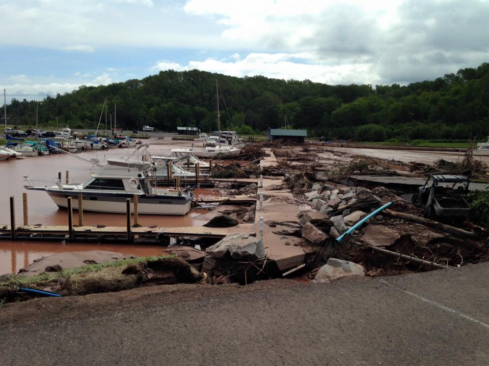
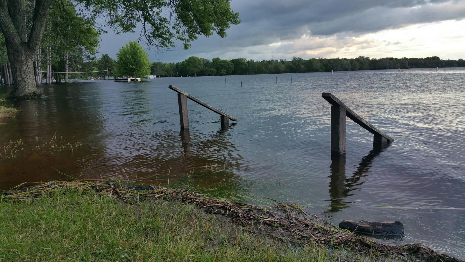
Photos
Bad River Reservation Story Map
 |
 |
 |
 |
| Hwy 13 Near Highbridge, WI (Tracy Packingham) |
In Mellen, WI (Tracy Packingham) |
Co. Hwy C near Marengo, WI (Amber Erickson) |
Co. Hwy C near Marengo, WI |
 |
 |
 |
 |
| Co Rd 122 near Saxon Harbor (Gary Jackson) |
Hwy 2 near Odanah (Gary Jackson) |
Co. Rd B Iron County (Iron County) |
Mellen, WI |
 |
 |
 |
 |
| Saxon Harbor in Wisconsin (Iron County Sheriff Department) |
Saxon Harbor in Wisconsin (Iron County Sheriff Department) |
Saxon Harbor in Wisconsin (Iron County Sheriff Department) |
Saxon Harbor in Wisconsin |
 |
|
 |
 |
| Moose Lake, MN (Mike Flip) |
Riverside Arena, Moose Lake, MN (Mike Flip) |
Generations Park, Moose Lake, MN (Mike Flip) |
Lake Ave, Moose Lake |
 |
 |
 |
.jpg) |
| Willow River Park, MN (Mike Flip) |
Willow River Dam, MN (Mike Flip)) |
Hwy 61 north of Willow River, MN (Amber Erickson) |
Hwy 137 near Ashland, WI |
Rain Reports
Public Information Statement
National Weather Service Duluth MN
308 AM CDT Wed Jul 13 2016

...PRELIMINARY 48-HOUR RAINFALL AMOUNTS FROM JULY 10-12...

These data are the PRELIMINARY 48-hour rainfall amounts from July 10
through early morning July 12. Some stations in this may have only
reported one of the two days.

Location                     Amount    Time/Date       Lat/Lon

...Sites in Minnesota...

...Aitkin County...
12 N Isle                    5.60 in   0800 AM 07/12   46.32N/93.50W
Rice Lake N.W.R.             5.12 in   1052 PM 07/12   46.54N/93.29W
Aitkin                       4.51 in   0130 AM 07/13   46.54N/93.71W
5 SSE Libby                  3.59 in   0700 AM 07/12   46.71N/93.29W
1 NNE Palisade               3.05 in   1045 PM 07/12   46.73N/93.49W
Libby                        2.27 in   0115 AM 07/13   46.79N/93.32W
1 S Hill City                2.20 in   0107 AM 07/13   46.96N/93.60W
Jacobson                     2.07 in   1045 PM 07/12   47.00N/93.27W

...Carlton County...
2 SW Moose Lake              5.45 in   0208 AM 07/13   46.42N/92.80W
1 SSW Pleasant Valley        5.23 in   0145 AM 07/13   46.52N/92.39W
2 E Kettle River             4.17 in   0807 AM 07/11   46.49N/92.84W
3 WNW Mahtowa                3.86 in   0600 AM 07/12   46.60N/92.68W
Wrenshall                    3.14 in   0800 AM 07/12   46.62N/92.38W
2 E Sawyer                   3.00 in   1000 AM 07/12   46.67N/92.59W
3 E Wright                   2.88 in   0600 AM 07/12   46.68N/92.95W
1 ESE Esko                   2.42 in   1205 AM 07/13   46.70N/92.34W

...Cass County...
4 ESE Casino                 6.22 in   0700 AM 07/12   46.40N/94.46W
1 E Chickamaw Beach          4.93 in   0700 AM 07/12   46.75N/94.36W
1 NW Motley                  4.82 in   0800 AM 07/12   46.36N/94.65W
3 S Pontoria                 4.30 in   0930 PM 07/11   46.82N/94.34W
3 N Chickamaw Beach          4.24 in   1200 PM 07/12   46.80N/94.39W
1 NNE Lake Shore             3.07 in   1030 PM 07/11   46.51N/94.35W
Walker Community Center      2.58 in   0900 AM 07/12   47.15N/94.65W
3 WSW Tobique                2.34 in   0145 AM 07/13   47.08N/94.10W
Walker                       2.19 in   1152 PM 07/12   47.09N/94.58W
4 NE Pontoria                2.00 in   0700 AM 07/11   46.92N/94.29W
Federal Dam 6 SW             1.75 in   0100 AM 07/13   47.17N/94.29W
Walker Airport               1.11 in   0655 AM 07/12   47.16N/94.65W
2 SE Ball Club               1.04 in   0115 AM 07/13   47.30N/93.90W
Cass Lake DNR                1.00 in   0201 AM 07/13   47.38N/94.61W

...Cook County...
The Bay Of Grand Marais      2.02 in   0656 PM 07/12   47.75N/90.34W
4 NE Grand Portage           1.59 in   0130 AM 07/13   48.01N/89.62W
4 W Grand Portage            1.45 in   0144 AM 07/13   47.95N/89.78W
Hovland                      1.37 in   0700 AM 07/12   47.84N/89.97W
2 WSW Lutsen                 1.30 in   0700 AM 07/12   47.62N/90.76W
3 WSW Hovland                1.10 in   0145 AM 07/13   47.82N/90.05W
13 NE Clear Lake             1.08 in   0139 AM 07/13   47.80N/90.95W
5 E Seagull Lake             1.07 in   0204 AM 07/13   48.12N/90.84W

...Crow Wing County...
1 N Brainerd                 8.90 in   1043 PM 07/11   46.37N/94.19W
2 NNW Brainerd               6.90 in   0715 PM 07/11   46.38N/94.21W
1 SW Breezy Point            6.40 in   0952 PM 07/12   46.58N/94.24W
Brainerd Airport             6.38 in   0653 PM 07/12   46.40N/94.13W
Brainerd                     6.31 in   0700 AM 07/12   46.34N/94.21W
1 SE Mission                 6.18 in   0945 PM 07/12   46.57N/94.03W
5 SE Breezy Point            6.14 in   0933 PM 07/12   46.55N/94.17W
Brainerd 7nw                 6.03 in   0700 AM 07/12   46.42N/94.30W
1 N Baxter                   5.68 in   0830 AM 07/12   46.36N/94.28W
2 W Woodrow                  5.54 in   0206 AM 07/13   46.40N/94.13W
3 WSW Mission                5.50 in   0800 AM 07/12   46.56N/94.12W
Wolford                      5.25 in   1015 PM 07/11   46.55N/93.98W
Cross Lake Dam               5.12 in   0100 AM 07/13   46.67N/94.12W
3 NNE Jenkins                4.10 in   0945 PM 07/12   46.69N/94.30W
3 NE Fort Ripley             4.07 in   0945 PM 07/12   46.20N/94.32W
Emily                        3.85 in   0700 AM 07/12   46.75N/93.96W
2 NNE Brainerd               3.75 in   0420 PM 07/11   46.38N/94.18W
2 NE Jenkins                 3.66 in   0944 PM 07/12   46.68N/94.29W
4 S Emily                    0.04 in   0211 AM 07/13   46.69N/93.95W

...Itasca County...
Lake Winnibigoshish          4.80 in   0100 AM 07/13   47.43N/94.05W
6 SSW Grand Rapids           2.17 in   0600 AM 07/12   47.14N/93.57W
12 N Grand Rapids            1.30 in   0620 AM 07/12   47.40N/93.51W
Pokegama Lk Dam              1.26 in   0100 AM 07/13   47.25N/93.59W
Keewatin                     1.04 in   0800 AM 07/12   47.40N/93.08W
2 E Ball Club                1.02 in   0800 AM 07/12   47.34N/93.88W
9 ENE Deer River             0.82 in   1021 PM 07/12   47.40N/93.62W
3 WSW Inger                  0.70 in   0204 AM 07/13   47.54N/94.05W
2 NNE Bigfork                0.57 in   0207 AM 07/13   47.78N/93.65W
5 W Bigfork                  0.57 in   0200 AM 07/13   47.75N/93.78W

...Koochiching County...
13 SSE Littlefork            0.63 in   0200 AM 07/13   48.21N/93.50W
Grand Falls                  0.59 in   0130 AM 07/13   48.20N/93.81W
Littlefork RAWS              0.48 in   0208 AM 07/13   48.39N/93.56W
1 W Ericksburg               0.45 in   0145 AM 07/13   48.49N/93.37W
Loman                        0.40 in   0145 AM 07/13   48.51N/93.80W
2 SE Clemenston              0.26 in   0145 AM 07/13   48.66N/94.40W
International Falls          0.21 in   0655 PM 07/12   48.57N/93.40W
Island View                  0.21 in   0818 AM 07/12   48.61N/93.19W

...Lake County...
3 W Two Harbors              1.96 in   0700 AM 07/12   47.04N/91.75W
Two Harbors                  1.92 in   0634 AM 07/12   47.03N/91.69W
Two Harbors 2.4 N            1.70 in   0700 AM 07/12   47.07N/91.68W
3 ENE Alger                  1.51 in   0700 AM 07/12   47.17N/91.62W
1 W Isabella                 1.46 in   0204 AM 07/13   47.62N/91.38W
1 NW Beaver Bay              1.28 in   0145 AM 07/13   47.27N/91.31W
14 W Isabella                1.25 in   0900 AM 07/12   47.59N/91.65W
9 ENE Babbitt                1.14 in   0130 AM 07/13   47.69N/91.76W
6 SE Silver Rapids           0.75 in   0200 AM 07/13   47.83N/91.67W
Fernberg Raws                0.68 in   0113 AM 07/13   47.95N/91.50W
25 E Ely                     0.68 in   0735 AM 07/12   47.93N/91.50W

...Pine County...
1 SW Hinckley                9.00 in   1200 AM 07/12   46.00N/92.96W
Askov                        8.06 in   0900 AM 07/12   46.18N/92.78W
3 WNW Friesland              7.32 in   0215 AM 07/13   46.11N/92.99W
2 NW Hinckley                7.30 in   0900 AM 07/12   46.04N/92.97W
7 ENE Bruno                  7.22 in   0800 AM 07/12   46.28N/92.50W
Willow River                 7.00 in   1040 PM 07/11   46.32N/92.84W
1 WSW Willow River           6.45 in   1045 PM 07/12   46.31N/92.86W
6 ESE Cloverdale             6.14 in   0115 AM 07/13   45.97N/92.62W
3 SSW Bruno                  4.60 in   0715 PM 07/11   46.24N/92.68W
2 N Greely                   4.24 in   0530 AM 07/12   45.78N/93.07W

...St. Louis County...
West Duluth                  4.00 in   0715 PM 07/11   46.74N/92.19W
2 NW Gary New Duluth         2.90 in   0900 AM 07/12   46.71N/92.23W
2 SW Lester Park             2.44 in   0645 AM 07/12   46.81N/92.06W
Duluth 6.9 NNE               2.39 in   0700 AM 07/12   46.87N/92.03W
5 NE Arnold                  2.29 in   0708 AM 07/12   46.95N/92.04W
Duluth Airport               2.28 in   0655 PM 07/12   46.84N/92.21W
2 NE Duluth                  2.19 in   0719 AM 07/12   46.81N/92.09W
1 NNE Duluth                 2.18 in   0745 AM 07/12   46.80N/92.11W
Duluth 1.5 NNW               2.12 in   0742 AM 07/12   46.80N/92.11W
Sucker River                 2.08 in   0145 AM 07/13   46.93N/91.86W
Duluth NWS                   2.05 in   0700 AM 07/12   46.84N/92.21W
Island Lake                  2.05 in   0900 AM 07/12   47.02N/92.07W
4 N Floodwood                2.04 in   0730 AM 07/12   47.00N/92.92W
2 WSW Lester Park            2.02 in   0210 AM 07/13   46.83N/92.06W
1 SW Saginaw                 2.01 in   0208 AM 07/13   46.84N/92.46W
Taft                         1.89 in   0610 AM 07/12   46.99N/92.31W
Floodwood                    1.88 in   1145 PM 07/12   46.93N/92.90W
Culver 0.2 W                 1.80 in   0700 AM 07/12   46.93N/92.56W
Burnett                      1.77 in   0115 AM 07/13   46.90N/92.51W
2 SSW Meadowlands            1.56 in   1145 PM 07/12   47.04N/92.74W
2 W Leonidas                 1.55 in   0700 AM 07/12   47.46N/92.63W
Skibo                        1.54 in   0122 AM 07/13   47.49N/91.99W
1 SE Brimson                 1.53 in   1245 AM 07/13   47.26N/91.85W
Makinen                      1.39 in   1208 AM 07/13   47.36N/92.36W
3 SSE Little Swan            1.35 in   1045 PM 07/12   47.25N/92.81W
Eveleth-Virginia Airport     1.32 in   0653 AM 07/12   47.42N/92.50W
5 E Hibbing                  1.27 in   0207 AM 07/13   47.39N/92.83W
Aurora                       1.21 in   1224 AM 07/13   47.52N/92.24W
2 NNW Hoyt Lakes             1.17 in   0115 AM 07/13   47.54N/92.17W
3 N Skibo                    1.15 in   0145 AM 07/13   47.53N/92.00W
Chisholm-Hibbing Airport     1.06 in   0653 PM 07/12   47.39N/92.84W
3E Orr                       1.04 in   0600 AM 07/12   48.06N/92.75W
5 S Ely                      1.02 in   0204 AM 07/13   47.83N/91.84W
2 NE Duluth                  0.96 in   1124 PM 07/12   46.81N/92.08W
3 SW Orr                     0.95 in   0208 AM 07/13   48.02N/92.85W
Cook                         0.85 in   0600 AM 07/12   47.85N/92.69W
3 SE Celina                  0.82 in   1045 PM 07/12   47.82N/93.02W
4 NE Babbitt                 0.73 in   0200 AM 07/13   47.70N/91.87W
Ely Usfs                     0.69 in   0915 AM 07/12   47.91N/91.83W
1 W Kabetogama               0.53 in   0131 AM 07/13   48.44N/93.05W
2 NW Robinson                0.52 in   0139 AM 07/13   47.89N/92.08W
3 W Crane Lake               0.49 in   0130 AM 07/13   48.26N/92.57W
1 S Buyck                    0.46 in   0145 AM 07/13   48.12N/92.52W
1 SSE Babbitt                0.42 in   0100 AM 07/13   47.62N/91.93W
16 E Buyck                   0.34 in   0204 AM 07/13   48.12N/92.16W
4 ENE Babbitt                0.33 in   0100 AM 07/13   47.67N/91.86W
Kabetogama General Store     0.32 in   0700 AM 07/12   48.41N/93.05W
1 WNW Kabetogama             0.31 in   0800 AM 07/12   48.45N/93.05W

...Sites in Wisconsin...

...Ashland County...
White River Near Ashland     5.30 in   0100 AM 07/13   46.50N/90.90W
Ashland Airport              5.26 in   0653 PM 07/12   46.55N/90.92W
Ashland                      5.05 in   0700 AM 07/12   46.58N/90.88W
Ashland 0.5 WNW              4.91 in   0700 AM 07/12   46.58N/90.88W
Ashland                      4.32 in   0214 AM 07/13   46.58N/90.88W
Glidden Raws                 4.09 in   0200 AM 07/13   46.14N/90.59W
Ashland                      3.66 in   0220 AM 07/13   46.58N/90.88W

...Bayfield County...
11 W Drummond                7.96 in   0700 AM 07/12   46.30N/91.50W
3 E Namekagon                7.63 in   0202 AM 07/13   46.20N/90.97W
3 W Clam Lake                6.29 in   0615 AM 07/12   46.17N/90.98W
4 W Clam Lake                6.29 in   0615 AM 07/12   46.17N/90.98W
3 W Clam Lake                5.36 in   0224 AM 07/13   46.17N/90.98W
11 SSE Brule                 4.50 in   0704 PM 07/11   46.40N/91.50W
Whittlesey Crk               4.23 in   0100 AM 07/13   46.59N/90.96W
6 WSW Ino                    3.42 in   1100 PM 07/11   46.49N/91.30W
Bayfield 1 Sw Wwtp           3.25 in   0800 AM 07/12   46.80N/90.84W
Red Cliff                    3.01 in   1021 PM 07/11   46.86N/90.79W
2 E Sand Bay                 2.88 in   0700 AM 07/12   46.94N/90.83W
Bayfield 9N                  2.88 in   0700 AM 07/12   46.94N/90.83W
Bayfield                     2.87 in   0222 AM 07/13   46.81N/90.81W
Washburn RAWS                2.50 in   0202 AM 07/13   46.64N/91.20W
1 W Bayfield                 2.44 in   1032 PM 07/12   46.81N/90.85W
3 E Sand Bay                 2.05 in   0930 PM 07/11   46.93N/90.82W

...Burnett County...
Danbury                      7.58 in   0100 AM 07/13   46.01N/92.37W
Grantsburg                   5.28 in   0700 AM 07/12   45.77N/92.69W
3 NE Randall                 5.11 in   0206 AM 07/13   45.74N/92.80W
1 ENE Yellowlake             4.00 in   0900 PM 07/11   45.94N/92.35W
9 SE Webster                 3.75 in   0700 AM 07/12   45.78N/92.23W
6 ENE Hertel                 3.40 in   0800 AM 07/12   45.85N/92.05W
Siren                        1.12 in   0655 AM 07/11   45.82N/92.37W

...Douglas County...
2 SW Superior                5.25 in   0711 PM 07/11   46.67N/92.09W
1 S Hawthorne                3.59 in   0700 AM 07/12   46.48N/91.86W
1 WSW Maple                  3.55 in   0126 AM 07/13   46.58N/91.75W
7 E Patzau                   3.46 in   0700 AM 07/12   46.48N/92.07W
2 ENE Oliver                 3.45 in   1200 AM 07/13   46.68N/92.15W
Superior Airport             3.32 in   0655 AM 07/12   46.69N/92.09W
1 NNW Superior               2.86 in   0224 AM 07/13   46.72N/92.07W
4 SSE South Range            2.85 in   1226 AM 07/13   46.55N/91.95W
3 ENE South Range            2.59 in   1241 AM 07/13   46.64N/91.92W

...Iron County...
Saxon 1WSW                   9.80 in   0700 AM 07/12   46.49N/90.44W

...Price County...
12 ENE Fifield               0.92 in   0147 AM 07/13   45.93N/90.18W
Phillips                     0.92 in   0655 AM 07/12   45.71N/90.42W
10 WSW Fifield               0.70 in   0223 AM 07/13   45.82N/90.62W
4 SE Phillips                0.25 in   0221 AM 07/13   45.64N/90.34W
5 WSW Spirit                 0.21 in   0211 AM 07/13   45.40N/90.20W

...Sawyer County...
2 WNW Seeley                 8.23 in   0600 AM 07/12   46.13N/91.40W
Hayward Airport              5.99 in   0653 PM 07/12   46.03N/91.44W
Hayward RAWS                 5.25 in   0203 AM 07/13   46.02N/91.45W
4 NW Winter                  2.10 in   0145 AM 07/13   45.87N/91.07W

...Washburn County...
7 WNW Minong                 6.87 in   0203 AM 07/13   46.14N/91.98W
Trego                        4.00 in   1045 PM 07/11   45.90N/91.82W
2 WNW Stone Lake             3.40 in   0700 AM 07/12   45.86N/91.58W
1 NW Spooner                 3.29 in   0700 AM 07/12   45.84N/91.91W
4 S Earl                     2.93 in   0700 AM 07/12   45.84N/91.76W
2 ENE Sarona                 2.91 in   0615 AM 07/12   45.72N/91.77W

Observations are collected from a variety of sources with varying
equipment and exposures. Not all data listed are considered official.
 |
Media use of NWS Web News Stories is encouraged! Please acknowledge the NWS as the source of any news information accessed from this site. |
|