


The St Croix River at Danbury - a location with over 100 years of river level history - recorded a maximum river stage of 11.66', which well exceeded the previous record of 8.7'.
Overview
|
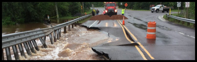
Roads, bridges and culverts were flooded and some washed out as four days of stormy weather and heavy rains in mid-June (14th-17th) caused record flooding across northwestern Wisconsin and adjacent areas of east central Minnesota. The hardest hit areas were the Wisconsin counties of Douglas, Bayfield, Ashland, Iron and Burnett where Gov. Scott Walker declared a state of emergency. Northwest Wisconsin took the brunt of the rain which resulted in the widespread flooding. Record crests occurred on some rivers in Wisconsin including: the Nemadji River at Superior, Whittlesy Creek at Ashland, White River at Ashland and the St. Croix River at Danbury. See the hydrographs below for specific crest information. See the map below for a closer look at rainfall totals in the flood region. Thursday, June 14th Late Thursday evening, the 14th of June, numerous thunderstorms moved across the Northland. These storms would set the stage for more flooding in the next few days. Two to 4 inches of rain fell across parts of northwestern Wisconsin. The most rain fell over Iron and Price Counties. It is this rain that helped cause the flooding in Houghton, MI. The NWS cooperative weather observer near Butternut had 1.06 inches of rain overnight while Hurley had 3.50 inches. Some roads and culverts were flooded. Some of the storms came with large hail. Half dollar size hail fell near New Post in Sawyer County, quarter-size hail fell near Ashland and Drummond while golfball size hail fell 7 miles east northeast of Butternut. Friday, June 15th The deluge of rain began during the day of Friday, June 15th. This first round of storms brought large hail, damaging winds and torrential rain from east central Minnesota, across the Twin Ports and across northwest Wisconsin. Most of the hail reported was nickle size and smaller, however golf ball size hail fell in Carlton, MN. Trees and power lines were blown down in Duluth. Flash flooding occurred near Hurley when 2 feet of water covered U. S. Highway 2 at the intersection of County Road D. Far northern tier counties of Wisconsin received the brunt of the rain with amounts ranging from 2 inches to over 3". Saturday/Saturday night June 16-17th More thunderstorms developed the evening of the 16th and lasted overnight. Downburst winds caused significant damage on the Lac Courte Oreilles Reservation. Shingles and facia were torn from the Headstart building on Trepania Road. Homes were damaged by fallen trees in the Hunter Township. Oak trees were uprooted. Another downburst brought down 30 large oak trees northwest of Spooner on Tanglewood Drive. Tehre was also major tree damage near Spooner where a homeowner reported 30 large oak trees were blown over or snapped. This damage was in a small area of about 500 feet wide and less than a quarter mile wide and was likely due to a microburst, which is an intense thunderstorm downdraft. Winds could have reached 80 to 90 miles an hour. The extreme rainfall with this batch of storms was widespread across northeast Minnestoa and northwest Wisconsin. Some specific 24 hour rainfall amounts include 2.70" in Ashland, WI, 2.11" in Hayward, 3.01" at Bruno, MN, 2.05 in Brainerd, 2.51 at Island Lake and 2" at Kabetogama. Sunday, June 17th More rain fell on Sunday, June 17th. 2" fell at Hayward, WI, 1.84" at Ashand1.35 at Hurley. Duluth, MN had 1", Brainerd 1.21" and 1.92" fell at Wright in Aitkin County.
|
Please DO NOT try to cross flooded roads! Most flooding deaths occur in vehicles.
|
 |
 |
 |
|
State Highway 35 at Pattison State Park |
U. S. Highway 2 in Superior flooded by Nemadji River NWS Photo |
Northern Great Lakes Visitor Center/U. S. Highway 2 Airfox Photography |
Flooding
The St Croix River at Danbury - a location with over 100 years of river level history - recorded a maximum river stage of 11.66', which well exceeded the previous record of 8.7'.
Hydrographs
 |
 |
 |
 |
| Nemadji River below Superior, W Actual crest was 29.5' |
Bois Brule River at Brule, WI | Whittlesey Creek at Ashland, WI | White River near Ashland, WI |
 |
 |
 |
 |
| Bad River near Odanah, WI | Namekagon River at Leonards, WI | Chippewa River near Winter, WI | St. Croix River near Danbury, WI |
 |
 |
 |
|
| St. Louis River at Scanlon, MN | Mississippi River near Aitkin, MN | Mississippi River at Brainerd |
Photos
 |
 |
 |
 |
| Highway 63 at Drummond, WI WI State Patrol photo |
U. S. Hwy 2 in Bayfied County North Fish Creek, 1 mile east of Co Rd G Wis DoT photo |
WI Highway 13 north of U. S. Highway 2 before Cherryville Road Airfox photgraphy |
U. S. Highway 2 Superior, WI NWS photo |
 |
 |
 |
 |
| Douglas Co. Hwy A 8 mi West of Solon Springs Photo by Denise Zielinski |
Co Hwy E at Mason, WI Photo by Kaela Schmude |
Weikel Rd, Delta, WI Photo by Becky Romack-Stanek |
Co Rd F between Benoit, WI, and U.S. Hwy 2 Airfox Photgraphy |
 |
 |
||
| Highway 23 at Nemadji River Crossing Carlton Co. Sheriff photo |
Before and After at Namadji River Gage South of Superior USGS photo |
Radar
Event radar loop from 9PM 6/14/2018 through 12AM 6/18/2018. The KDLH radar was offline on the 16th into the 17th which is why the data over the Duluth CWA drops out for a time. Radar loop courtesy Iowa Environmental Mesonet.
Storm Reports
Public Information Statement
National Weather Service Duluth MN
600 AM CDT Mon Jun 18 2018
..TIME... ...EVENT... ...CITY LOCATION... ...LAT.LON...
..DATE... ....MAG.... ..COUNTY LOCATION..ST.. ...SOURCE....
..REMARKS..
0340 AM HAIL 1 NNE DRUMMOND 46.34N 91.25W
06/15/2018 E1.00 INCH BAYFIELD WI PUBLIC
RELAYED VIA FACEBOOK. LARGEST HAILSTONES
WERE QUARTER SIZED. TIME ESTIMATED BY RADAR.
0341 AM HAIL 6 E HAYWARD 46.01N 91.36W
06/15/2018 M0.75 INCH SAWYER WI TRAINED SPOTTER
LASTED ABOUT 10 MINUTES
0351 AM HAIL 2 ESE PORT WING 46.77N 91.35W
06/15/2018 M0.75 INCH BAYFIELD WI TRAINED SPOTTER
THE LARGEST HAILSTONES WERE DIME SIZED. TIME
ESTIMATED BY RADAR.
0401 AM HAIL 10 NNW NEW POST 46.03N 91.27W
06/15/2018 M0.75 INCH SAWYER WI TRAINED SPOTTER
0403 AM HAIL CHIPPEWA LAKE 45.93N 91.20W
06/15/2018 M0.50 INCH SAWYER MN TRAINED SPOTTER
WITH SOME 3/4INCH HAIL
0403 AM HAIL 20 E HAYWARD 46.01N 91.06W
06/15/2018 M0.75 INCH SAWYER WI TRAINED SPOTTER
MIXED WITH HALF INCH HAIL. NO WIND
0409 AM HAIL 3 N NEW POST 45.93N 91.19W
06/15/2018 E0.75 INCH SAWYER WI PUBLIC
LARGEST HAILSTONES WERE DIME SIZED. TIME
ESTIMATED FROM RADAR.
0415 AM HAIL 1 WSW ASHLAND 46.58N 90.88W
06/15/2018 M1.00 INCH ASHLAND WI PUBLIC
THE LARGEST HAILSTONES WERE QUARTER SIZED.
TIME ESTIMATED BY RADAR.
0415 AM HAIL 5 NNE NEW POST 45.96N 91.13W
06/15/2018 M1.25 INCH SAWYER WI PUBLIC
LARGEST HAILSTONES WERE HALF DOLLAR SIZED.
0418 AM HAIL ASHLAND 46.58N 90.87W
06/15/2018 E0.50 INCH ASHLAND WI TRAINED SPOTTER
0429 AM HAIL S REMER 47.06N 93.91W
06/15/2018 E0.25 INCH CASS MN TRAINED SPOTTER
0430 AM HAIL 4 SSW ASHLAND 46.53N 90.90W
06/15/2018 E1.00 INCH ASHLAND WI PUBLIC
REPORT RELAYED VIA TWITTER.
0432 AM HAIL 2 NW WASHBURN 46.70N 90.91W
06/15/2018 E0.25 INCH BAYFIELD WI PUBLIC
0504 AM HAIL 1 ENE PARK FALLS 45.94N 90.43W
06/15/2018 E0.75 INCH PRICE WI COCORAHS
MIXED WITH PEA SIZE HAIL
0548 AM HAIL 2 E BUTTERNUT 46.01N 90.45W
06/15/2018 M0.75 INCH ASHLAND WI PUBLIC
0555 AM HAIL PENCE 46.42N 90.27W
06/15/2018 E0.75 INCH IRON WI PUBLIC
0605 AM HAIL 7 ENE BUTTERNUT 46.05N 90.36W
06/15/2018 M1.75 INCH ASHLAND WI PUBLIC
LARGEST HAILSTONES WERE GOLF BALL SIZED.
RELAYED VIA FACEBOOK. TIME ESTIMATED BY
RADAR.
0645 AM HAIL NW MERCER 46.17N 90.06W
06/15/2018 M0.50 INCH IRON WI TRAINED SPOTTER
REPORT RELAYED VIA MPING.
0715 AM MARINE TSTM WIND 13 SSE LITTLE MARAIS 47.25N 90.96W
06/15/2018 M78 MPH LSZ162 MN SHIP
REPORTED BY THE JAMES R. BARKER.
0843 AM HAIL 1 NW TWO HARBORS 47.04N 91.69W
06/15/2018 M0.25 INCH LAKE MN TRAINED SPOTTER
LOTS OF PEA SIZED HAIL.
0957 AM HAIL POPLAR 46.58N 91.79W
06/15/2018 M0.50 INCH DOUGLAS WI PUBLIC
1010 AM HAIL MOOSE LAKE 46.45N 92.77W
06/15/2018 M1.75 INCH CARLTON MN BROADCAST MEDIA
TIME ESTIMATED BY RADAR.
1015 AM FLASH FLOOD 2 NW HURLEY 46.48N 90.22W
06/15/2018 IRON WI 911 CALL CENTER
WATER COVERING ROADWAY, WHICH IS TWO FEET
DEEP NEAR THE INTERSECTION OF US HIGHWAY 2
AND COUNTY HIGHWAY D.
1020 AM HAIL 2 S MOOSE LAKE 46.42N 92.77W
06/15/2018 M0.75 INCH PINE MN TRAINED SPOTTER
1023 AM HAIL MOOSE LAKE 46.45N 92.77W
06/15/2018 M1.00 INCH CARLTON MN PUBLIC
PHOTO RELAYED VIA FACEBOOK.
1100 AM HAIL NICKERSON 46.41N 92.50W
06/15/2018 E1.00 INCH PINE MN PUBLIC
LARGEST HAILSTONES WERE QUARTER SIZED.
1132 AM HAIL NICKERSON 46.41N 92.50W
06/15/2018 E1.00 INCH PINE MN PUBLIC
1155 AM HAIL 2 WSW HOLYOKE 46.45N 92.43W
06/15/2018 M0.75 INCH CARLTON MN TRAINED SPOTTER
LARGEST HAILSTONES WERE DIME SIZED.
1213 PM HAIL 5 S LIBBY 46.71N 93.34W
06/15/2018 E0.25 INCH AITKIN MN PUBLIC
TIME ESTIMATED FROM RADAR.
1222 PM HAIL LAKE NEBAGAMON 46.51N 91.69W
06/15/2018 M0.75 INCH DOUGLAS WI TRAINED SPOTTER
1224 PM HAIL 5 N MCGREGOR 46.68N 93.32W
06/15/2018 M1.00 INCH AITKIN MN PUBLIC
LARGEST HAILSTONES WERE QUARTER SIZED.
1225 PM HAIL MELLEN 46.32N 90.66W
06/15/2018 M0.75 INCH ASHLAND WI TRAINED SPOTTER
PEAS TO DIME SIZED HAIL AT THE TIME OF THE
CALL.
1230 PM HAIL 1 ESE LAKE NEBAGAMON 46.50N 91.68W
06/15/2018 M0.88 INCH DOUGLAS WI TRAINED SPOTTER
LARGEST HAILSTONES WERE NICKEL SIZED. TIME
ESTIMATED FROM RADAR.
1230 PM TSTM WND DMG 1 ESE LAKE NEBAGAMON 46.50N 91.68W
06/15/2018 DOUGLAS WI TRAINED SPOTTER
10 INCH DIAMETER POPLAR TREE DOWNED ONTO A
POWER LINE. TIME ESTIMATED BY RADAR.
1233 PM HAIL CARLTON 46.66N 92.42W
06/15/2018 E0.50 INCH CARLTON MN PUBLIC
1240 PM TSTM WND DMG DULUTH 46.78N 92.12W
06/15/2018 ST. LOUIS MN 911 CALL CENTER
SEVERAL REPORTS OF TREES AND POWER LINES
DOWN IN THE CITY OF DULUTH. TIME ESTIMATED
BY RADAR.
1253 PM TSTM WND DMG 3 NNW HERMANTOWN 46.84N 92.26W
06/15/2018 ST. LOUIS MN NWS EMPLOYEE
6 TO 8 INCH DIAMETER TREE DOWNED NEAR THE
INTERSECTION OF US-53 AND MN-194. TIME
ESTIMATED BY RADAR.
1255 PM MARINE TSTM WIND 4 SE DULUTH 46.74N 92.06W
06/15/2018 M36 MPH ST. LOUIS MN PUBLIC
MARINE THUNDERSTORM WIND GUST MEASURED BY
WEATHER STATION KMNDULUT1.
0101 PM MARINE TSTM WIND SKY HARBOR AIRPORT 46.72N 92.04W
06/15/2018 M39 MPH ST. LOUIS MN AWOS
AWOS STATION KDYT.
0110 PM FLOOD 1 WSW MELLEN 46.32N 90.67W
06/15/2018 ASHLAND WI LAW ENFORCEMENT
4 TO 5 INCH DEPTH OF WATER OVER ROAD ON THE
WEST SIDE OF MELLEN ON COUNTY HIGHWAY GG.
0115 PM FLOOD 2 SSW DULUTH 46.76N 92.13W
06/15/2018 ST. LOUIS MN BROADCAST MEDIA
8 TO 10 INCH DEPTH OF WATER COVERING THE
ROADWAY NEAR THE INTERSECTION OF S 27TH
AVENUE WEST AND WEST MICHIGAN STREET.
0125 PM FLOOD 1 S DULUTH 46.77N 92.12W
06/15/2018 ST. LOUIS MN BROADCAST MEDIA
A FOOT OF WATER ON THE ROADWAY NEAR THE
INTERSECTION OF GARFIELD AVENUE AND WEST
RAILROAD STREET.
0219 PM HAIL 3 WSW BARKSDALE 46.61N 90.99W
06/15/2018 M0.75 INCH BAYFIELD WI PUBLIC
PEA TO DIME SIZED HAIL FALLING AT THE TIME
OF THE REPORT.
0315 PM FLOOD INO 46.53N 91.18W
06/15/2018 BAYFIELD WI 911 CALL CENTER
WATER OVER US-2 NEAR INO.
0315 PM FLOOD 3 W ASHLAND 46.57N 90.94W
06/15/2018 BAYFIELD WI 911 CALL CENTER
WATER OVER ROAD NEAR THE INTERSECTION OF
STATE HIGHWAY 137 AND SAJDAK ROAD.
0318 PM HAIL NWS DULUTH 46.84N 92.21W
06/15/2018 M0.25 INCH ST. LOUIS MN OFFICIAL NWS OBS
0330 PM HAIL 1 NW MANITOWISH 46.15N 90.03W
06/15/2018 M0.25 INCH IRON WI TRAINED SPOTTER
NO DAMAGE.
0430 PM HAIL SPOONER 45.82N 91.89W
06/15/2018 M0.25 INCH WASHBURN WI PUBLIC
HAILSTONES SLIGHTLY LARGER THAN PEA SIZED.
0432 PM HAIL SPOONER 45.82N 91.88W
06/15/2018 E0.25 INCH WASHBURN WI PUBLIC
0436 PM HAIL SPOONER 45.82N 91.89W
06/15/2018 M0.88 INCH WASHBURN WI TRAINED SPOTTER
OCCURRING AT THE TIME OF THE CALL.
0510 AM FLOOD 5 SSW GURNEY 46.41N 90.57W
06/16/2018 ASHLAND WI LAW ENFORCEMENT
TYLER FORKS RIVER FLOWING QUICKLY OVER STATE
HIGHWAY 169.
0907 AM HAIL 4 NNW NEW POST 45.95N 91.24W
06/16/2018 M0.25 INCH SAWYER WI TRAINED SPOTTER
0153 PM FLASH FLOOD 5 NE COOK 47.90N 92.61W
06/16/2018 ST. LOUIS MN LAW ENFORCEMENT
LUTHEY ROAD AND BEATY ROAD CLOSED DUE TO
WASHOUTS AND WATER OVER ROADWAY.
1200 PM FLASH FLOOD COOK 47.85N 92.69W
06/16/2018 ST. LOUIS MN TRAINED SPOTTER
CURB TO CURB FLOODING IN ON 1ST AVE WEST.
AND WATER OVER HWY 53 IN TOWN.
1018 PM HAIL 6 E WOODROW 46.38N 93.95W
06/16/2018 M0.25 INCH CROW WING MN TRAINED SPOTTER
SPOTTER REPORTED ONE MINUTE OF PEA SIZE HAIL
AT THEIR LOCATION.
1024 PM HAIL 1 SSE LA POINTE 46.76N 90.78W
06/16/2018 E1.00 INCH ASHLAND WI PUBLIC
REPORTED VIA MPING.
0100 AM FLASH FLOOD DRUMMOND 46.33N 91.26W
06/17/2018 BAYFIELD WI LAW ENFORCEMENT
DELTA-DRUMMOND ROAD IS COMPLETELY WASHED OUT
NEAR DRUMMOND. COUNTY HIGHWAY N NEAR PIGEON
LAKE WEST OF DRUMMOND AND NORTH AND SOUTH
SWEDEN ROADS NEAR GRAND VIEW ARE IMPASSIBLE
DUE TO HIGH WATER.
0123 AM FLASH FLOOD 1 N MOOSE JUNCTION 46.30N 92.15W
06/17/2018 DOUGLAS WI LAW ENFORCEMENT
MULTIPLE ROADS REPORTED WASHED OUT IN THE
SUMMIT AND DAIRYLAND AREAS.
0136 AM FLASH FLOOD 1 S PLEASANT VALLEY 46.52N 92.39W
06/17/2018 CARLTON MN LAW ENFORCEMENT
STATE HIGHWAY 23 IS WASHED OUT AT THE
NEMADJI RIVER MILE MARKER 322.
0140 AM FLASH FLOOD 2 S GLEN 46.39N 93.52W
06/17/2018 AITKIN MN LAW ENFORCEMENT
STATE HIGHWAY 47 IS WASHED OUT SOUTH OF
GLEN.
0140 AM FLASH FLOOD 4 E MALMO 46.33N 93.44W
06/17/2018 AITKIN MN LAW ENFORCEMENT
WATER OVER COUNTY TRUNK 2 FOUR MILES EAST OF
MALMO. VEHICLE HYDROPLANED INTO DITCH.
0140 AM TSTM WND DMG 4 ENE WEBSTER 45.89N 92.27W
06/17/2018 BURNETT WI PUBLIC
REPORT OF TRAMPOLINE, GARBAGE CANISTERS, AND
A BOAT WERE BLOWN OVER. ALSO, SOME METAL WAS
BLOWN OFF A STRUCTURE. TIMING ESTIMATED FROM
MRMS RADAR.
0214 AM FLASH FLOOD FOXBORO 46.48N 92.28W
06/17/2018 DOUGLAS WI BROADCAST MEDIA
VIEWER REPORT OF FLOODING IN THE FOXBORO
AREA AND RAINFALL AMOUNTS IN EXCESS OF 8".
0214 AM FLASH FLOOD 8 W SOLON SPRINGS 46.36N 91.98W
06/17/2018 DOUGLAS WI BROADCAST MEDIA
VIEWER REPORT THAT COUNTY HIGHWAY A BETWEEN
SOLON SPRINGS AND AMNICON LAKE IS FLOODED.
SOME TREES DOWN AS WELL.
0217 AM FLASH FLOOD 2 SW SANBORN 46.41N 90.95W
06/17/2018 BAYFIELD WI BROADCAST MEDIA
VIEWER REPORT THAT ARGO ROAD 12 MILES SOUTH
OF ASHLAND IS WASHED OUT.
0220 AM TSTM WND DMG 1 SE LITTLE ROUND LAKE 45.96N 91.36W
06/17/2018 SAWYER WI EMERGENCY MNGR
LAC COUTRE OREILLES EMERGENCY MANAGEMENT
REPORTED NUMEROUS TREES DOWN, AROUND 8-12
INCHES IN DIAMETER. THREE OF THE TREES
FELL ONTO STRUCTURES AND CARS. BULK OF THE
TREES FELL SOUTH OF JUNCTION OF FROEMEL ROAD
AND TREPANIA ROAD. TIME ESTIMATED BY MRMS RADAR.
0430 AM FLASH FLOOD 1 SE INO 46.52N 91.16W
06/17/2018 BAYFIELD WI BROADCAST MEDIA
KEYSTONE ROAD WASHED OUT BY NORTH FISH
CREEK.
0430 AM FLASH FLOOD 3 SSW BARKSDALE 46.58N 90.96W
06/17/2018 BAYFIELD WI PUBLIC
ROADWAY FLOODED NEAR THE INTERSECTION OF
US-2 AND COUNTY HIGHWAY G NEAR NORTH FISH
CREEK.
0430 AM FLASH FLOOD 2 SSW BARKSDALE 46.59N 90.96W
06/17/2018 BAYFIELD WI BROADCAST MEDIA
WI-13 ROAD FLOODED BEFORE THE INTERSECTION
OF WI-13 AND CHERRYVILLE ROAD NORTH OF US-2.
WATER OVERFLOWED FROM WHITTLESEY CREEK AND
FISH CREEK.
0430 AM FLASH FLOOD 1 E INO 46.53N 91.15W
06/17/2018 BAYFIELD WI BROADCAST MEDIA
BRIDGE WASHED OUT ALONG US-2 WEST OF TOMICH
ROAD AND EAST OF INO. NORTH FISH CREEK
OVERFLOWED.
0430 AM FLASH FLOOD 2 S INO 46.50N 91.18W
06/17/2018 BAYFIELD WI BROADCAST MEDIA
PANASUK ROAD FLOODED NEAR COUNTY ROAD E DUE
TO NORTH FISH CREEK OVERFLOWING.
0430 AM FLASH FLOOD MASON 46.43N 91.06W
06/17/2018 BAYFIELD WI BROADCAST MEDIA
WHITE RIVER PARK IN MASON, WI FLOODED DUE TO
OVERFLOW FROM THE WHITE RIVER FLOWAGE 314.
0430 AM FLASH FLOOD 4 SSW BARKSDALE 46.57N 90.95W
06/17/2018 BAYFIELD WI PUBLIC
WATER FLOWING OVER HIGHWAY 137 NEAR NORTH
FISH CREEK.
1230 PM HAIL 2 ENE WALDECK 46.68N 93.57W
06/17/2018 M1.25 INCH AITKIN MN TRAINED SPOTTER
1250 PM TSTM WND DMG 4 SSE LIBBY 46.73N 93.31W
06/17/2018 AITKIN MN EMERGENCY MNGR
TREES DOWN ALONG HIGHWAY 65 SPORADICALLY
FROM LIBBY TO MCGREGOR. TIME ESTIMATED FROM
RADAR.
0210 PM TSTM WND DMG 1 E LAWLER 46.54N 93.15W
06/17/2018 AITKIN MN TRAINED SPOTTER
100 FOOT ROOF ON BARN RIPPED OFF. SEVERAL
LARGE TREES DOWN.
0239 PM TSTM WND DMG 6 SW SOUTH RANGE 46.56N 92.08W
06/17/2018 DOUGLAS WI NWS EMPLOYEE
A FEW 6 INCH DIAMETER TREES SNAPPED HALFWAY
UP THE TRUNK. TIME ESTIMATED FROM RADAR.
0254 PM HAIL CHAFFEY 46.40N 92.16W
06/17/2018 M1.00 INCH DOUGLAS WI AMATEUR RADIO
0320 PM TSTM WND DMG 1 NE SOLON SPRINGS 46.36N 91.81W
06/17/2018 DOUGLAS WI 911 CALL CENTER
TREE DOWNED IN SOLON SPRINGS ON SOUTH BEACH
AVENUE. TIME ESTIMATED BY RADAR.
0329 PM HAIL 2 ESE BENNETT 46.43N 91.81W
06/17/2018 E0.50 INCH DOUGLAS WI PUBLIC
REPORT RELAYED VIA MPING.
0355 PM FLASH FLOOD 1 SSE OULU 46.62N 91.53W
06/17/2018 BAYFIELD WI CO-OP OBSERVER
1.73" OF RAIN IN 40 MINUTES. FLOODING OVER
ROADS ON FARM. SEASONAL CREEK IS RUNNING 15X
MORE THAN WHAT IT CAN HOLD. WATER IS 6"
ABOVE ROAD SURFACE BETWEEN FIELDS.
0421 PM FLOOD 1 SSE DULUTH 46.76N 92.11W
06/17/2018 ST. LOUIS MN PUBLIC
REPORT RELAYED VIA MPING.
0430 PM FLASH FLOOD 12 WNW CABLE 46.25N 91.54W
06/17/2018 BAYFIELD WI TRAINED SPOTTER
DENVER ROAD CLOSED DUE TO WATER OVER THE
ROAD FROM THE OUNCE RIVER. 7.9" OF RAIN FROM
930 PM LAST NIGHT TO 430 PM TODAY. TREES
DOWN ALONG THE HIGHWAY WHILE DRIVING HOME.
0436 PM TSTM WND DMG 3 W VAN BUSKIRK 46.39N 90.20W
06/17/2018 IRON WI PUBLIC
WIMI RADIO'S FACEBOOK PAGE HAS QUITE A FEW
PICTURES OF SHREDDED TREES ALONG HIGHWAY C
IN/NEAR CAREY, WI.
0503 PM TSTM WND DMG 2 W MERCER 46.17N 90.11W
06/17/2018 IRON WI PUBLIC
REPORT RELAYED VIA MPING. POWER POLES
BROKEN.
0515 PM FLOOD 3 SSE MOQUAH 46.54N 91.05W
06/17/2018 BAYFIELD WI 911 CALL CENTER
BRIDGE DAMAGED NEAR US HIGHWAY 63 AND US
HIGHWAY 2. US-63 AND 2 CLOSED TO DRUMMOND
WI. CARS HAVE DRIVEN ONTO FLOODED ROADWAYS
AND BEEN STRANDED.
0700 PM FLASH FLOOD 2 ESE GILE 46.41N 90.19W
06/17/2018 IRON WI 911 CALL CENTER
WATER FLOWING OVER KNIGHT ROAD ON THE GILE
FLOWAGE.
1142 PM FLASH FLOOD 4 NE TWO HARBORS 47.08N 91.61W
06/17/2018 LAKE MN LAW ENFORCEMENT
COUNTY HIGHWAY 3 IS WASHED OUT BETWEEN LOOP
ROAD AND FORS ROAD.
1144 PM FLASH FLOOD 3 NW TWO HARBORS 47.05N 91.72W
06/17/2018 LAKE MN LAW ENFORCEMENT
AIRPORT ROAD WASHED OUT BETWEEN HIGHWAY 12
AND BIG ROCK ROAD.
1147 PM FLASH FLOOD 5 NNW TWO HARBORS 47.10N 91.72W
06/17/2018 LAKE MN LAW ENFORCEMENT
OLD DRUMMOND ROAD IS WASHED OUT AT THE
STEWART RIVER BETWEEN BIG ROCK ROAD AND HOLM
ROAD.
1220 AM FLOOD RIVERSIDE 46.08N 92.25W
06/18/2018 BURNETT WI LAW ENFORCEMENT
WISCONSIN HIGHWAY 35 IS CLOSED AT RIVERSIDE
DUE TO FLOODING.
0523 AM FLOOD 1 E SUPERIOR 46.70N 92.03W
06/18/2018 DOUGLAS WI LAW ENFORCEMENT
US HIGHWAY 2 IS CLOSED BETWEEN 31ST AVE EAST
AND 37TH AVE EAST DUE TO FLOODING.
Rain Reports
Public Information Statement
National Weather Service Duluth MN
354 PM CDT Mon Jun 18 2018

...Highest 3 Day Rainfall Totals From June 15-17 2018...

The reports below are not necessarily the final amount
for each location. All report times are valid on
June 17, 2018.

 Inches  Location                 ST  County           Time
 ------  -----------------------  --  --------------   -------
 15.04   2 W DRUMMOND             WI  BAYFIELD         0729 PM
 10.73   11 SSE BRULE             WI  BAYFIELD         0706 PM
  9.36   11 W DRUMMOND            WI  BAYFIELD         0700 AM
  8.32   GILE                     WI  IRON             0840 PM
  8.08   BRUNO                    MN  PINE             0740 PM
  7.45   WASHBURN RAWS            WI  BAYFIELD         0702 PM
  7.16   1 E ODANAH               WI  ASHLAND          0734 PM
  6.51   6 ENE PATZAU             WI  DOUGLAS          0741 PM
  6.36   ASHLAND                  WI  ASHLAND          0738 PM
  6.32   1 SSW PLEASANT VALLEY    MN  CARLTON          0645 PM
  6.06   7 NW TWO HARBORS         MN  LAKE             0700 PM
  5.94   7 WNW MINONG             WI  WASHBURN         0703 PM
  5.85   HURLEY                   WI  IRON             0800 AM
  5.56   1 S HAWTHORNE            WI  DOUGLAS          0700 AM
  5.50   2 NW KERRICK             MN  PINE             0530 PM
  5.44   HAYWARD AIRPORT          WI  SAWYER           0653 PM
  5.40   1 WSW MAPLE              WI  DOUGLAS          0732 PM
  5.25   HAYWARD RAWS             WI  SAWYER           0703 PM
  5.21   1 W SOLON SPRINGS        WI  DOUGLAS          0700 AM
  5.00   BREEZY POINT             MN  CROW WING        0835 AM
  4.90   4 SSE SOUTH RANGE        WI  DOUGLAS          0740 PM
  4.70   12 ENE FIFIELD           WI  PRICE            0647 PM
  4.69   1 WSW PHILLIPS           WI  PRICE            0800 PM
  4.52   1 NNW CLOQUET            MN  CARLTON          0729 PM
  4.31   GLIDDEN RAWS             WI  ASHLAND          0700 PM
  4.24   3 NNE JENKINS            MN  CROW WING        0645 PM
  4.17   6 W CASTLE DANGER        MN  LAKE             0731 PM
  4.09   3 W CLAM LAKE            WI  BAYFIELD         0733 PM
  3.94   2 SW MOOSE LAKE          MN  CARLTON          0708 PM
  3.87   5 NW SAND BAY            WI  BAYFIELD         0721 PM
  3.85   LITTLEFORK               MN  KOOCHICHING      0730 PM
  3.79   6 ESE CLOVERDALE         MN  PINE             0715 PM
  3.75   3 E NAMEKAGON            WI  BAYFIELD         0702 PM
  3.68   13 SSE LITTLEFORK        MN  KOOCHICHING      0700 PM
  3.64   FEDERAL DAM 3 WNW        MN  CASS             0700 PM
  3.59   CROSS LAKE DAM           MN  CROW WING        0700 PM
  3.54   1 SW SAGINAW             MN  ST. LOUIS        0708 PM
  3.53   2 ENE OLIVER             WI  DOUGLAS          0700 PM
  3.45   BIG FALLS                MN  KOOCHICHING      0730 PM
  3.43   7 SSE WALES              MN  LAKE             0855 AM
  3.39   BURNETT                  MN  ST. LOUIS        0715 PM
  3.31   16 E BUYCK               MN  ST. LOUIS        0704 PM
  3.28   1 NW BEAVER BAY          MN  LAKE             0645 PM
  3.27   2 NW SUPERIOR            WI  DOUGLAS          1030 PM
  3.22   2 S WRENSHALL            MN  CARLTON          0830 AM
  3.20   2 WNW PALMERS            MN  ST. LOUIS        0729 PM
  3.16   SCANLON                  MN  CARLTON          0730 PM
  3.15   2 SE BAYFIELD            WI  ASHLAND          0733 PM
  3.14   1 S BUYCK                MN  ST. LOUIS        0645 PM
  3.12   NORTHOME                 MN  KOOCHICHING      0731 PM
  3.12   1 ESE ESKO               MN  CARLTON          0735 PM
  3.00   3 E PAYNE                MN  ST. LOUIS        0143 PM

Observations are collected from a variety of sources with varying
equipment and exposures. We thank all volunteer weather observers
for their dedication. Not all data listed are considered official.
Environment
Upper air analysis from 00z 6/16/2018.
 |
 |
 |
| 250mb | 300mb | 500mb |
 |
 |
 |
| 700mb | 850mb | 925mb |
 |
||
| Surface |
Upper air analysis from 00z 6/17/2018.
 |
 |
 |
| 250mb | 300mb | 500mb |
 |
 |
 |
| 700mb | 850mb | 925mb |
 |
||
| Surface |
 |
Media use of NWS Web News Stories is encouraged! Please acknowledge the NWS as the source of any news information accessed from this site. |
|