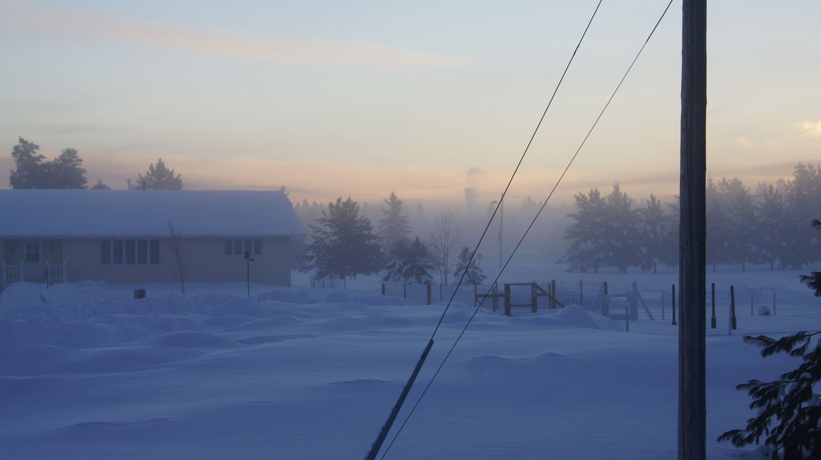
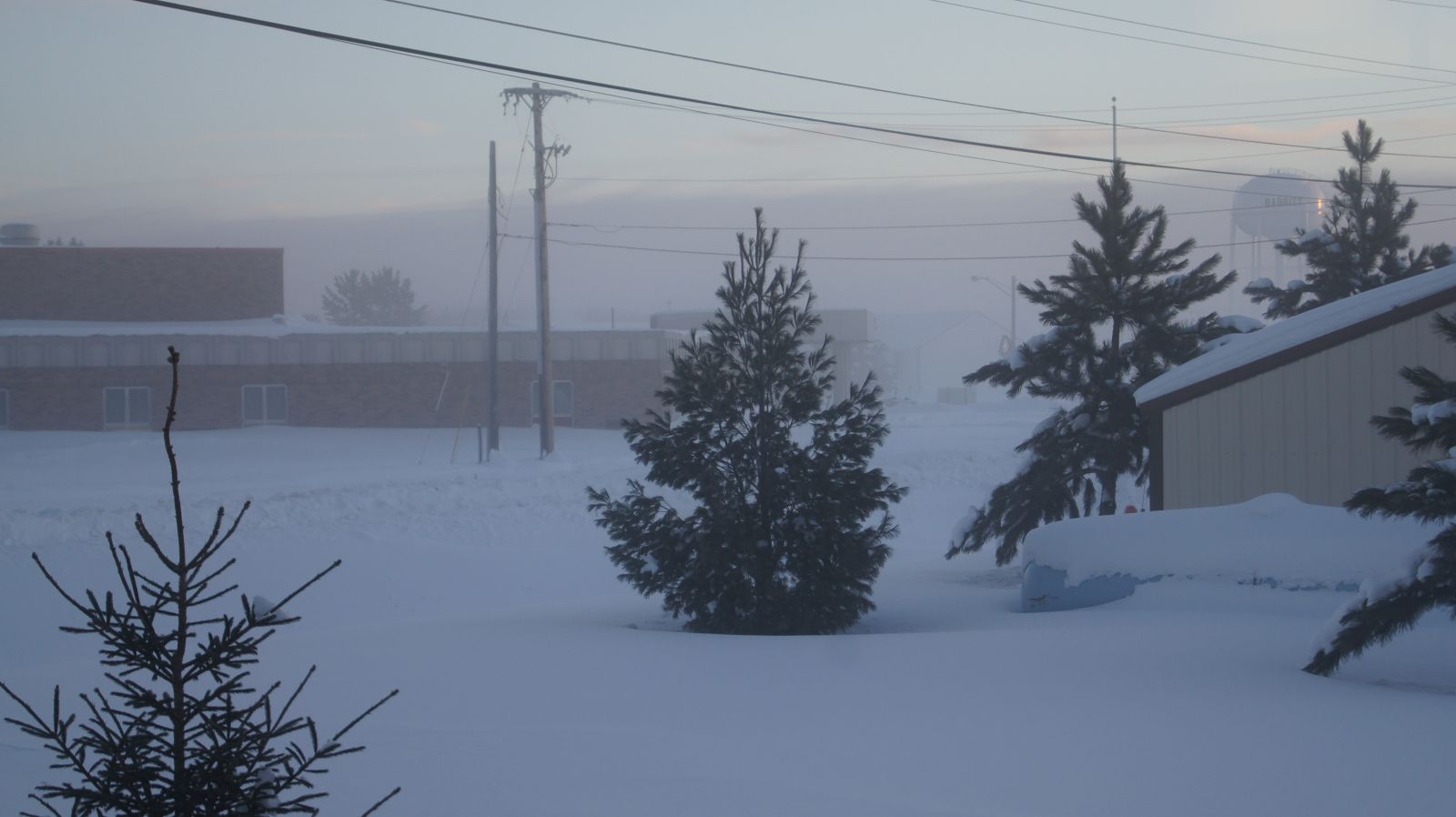
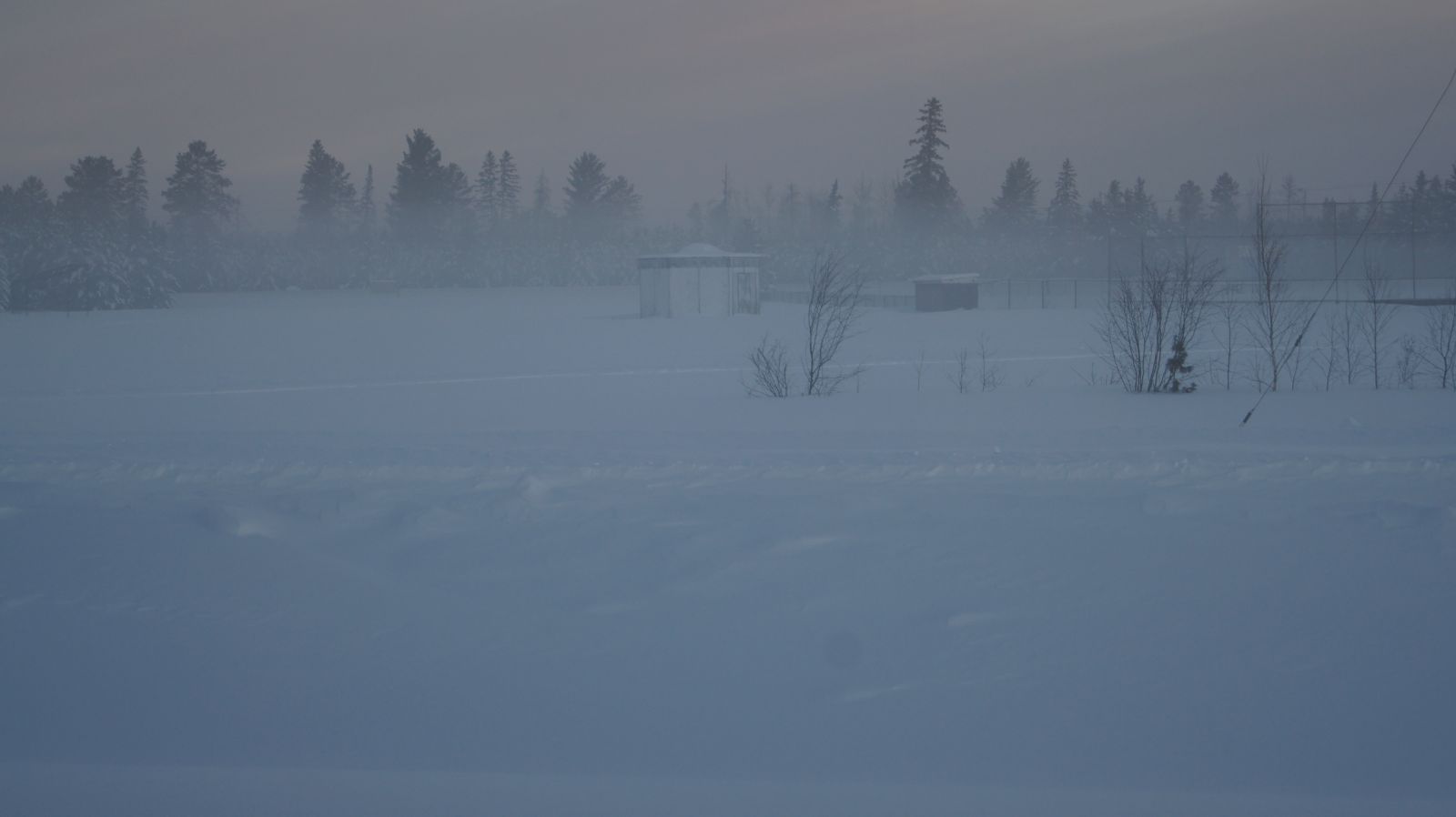
The above pictures are from Babbitt, Minnesota where a frigid morning low temperature of -46 degrees was recorded on January 21, 2011. The pictures were taken by observer Ryan Scharber. The pictures show ice fog, which is usually a shallow fog consisting of suspended ice crystals. Ice fog usually only occurs when temperatures fall below -22 degrees Fahrenheit (-30 Celsius) according to the AMS Glossary. Normally, fog consists of tiny water droplets, or supercooled water droplets. However, when temperatures are as cold as they were this morning in parts of northern Minnesota, it becomes too cold for liquid water to exist, and small ice crystals can develop if the amount of water vapor in the air is sufficient.
Here is a map of a few notable low temperatures across the area. The contoured shading in the background was created by interpolating the observations using GIS software. Therefore, the contours may not necessarily match individual observations, but the overall trend in temperatures is pretty close. Areas near Lake Superior managed to stay much warmer than outlying areas, and you can even detect a hint of urban heat influences around the Twin Cities.

Fast Facts
List Of Coldest Morning Lows
THE FOLLOWING ARE OBSERVED LOW TEMPERATURES THROUGH 900 AM FRIDAY
JANUARY 21 2011. TEMPERATURES ARE IN DEGREES FAHRENHEIT.


 TEMP    LOCATION                 ST  COUNTY           SOURCE
 ----    -----------------------  --  --------------   -------
 -46     INTERNATIONAL FALLS      MN  KOOCHICHING      ASOS
 -46     BABBITT                  MN  ST LOUIS         COOP
 -43     EMBARRASS                MN  ST LOUIS         COOP
 -43     BIGFORK                  MN  ITASCA           RAWS
 -43     ASH LAKE                 MN  ST LOUIS         MNDOT
 -43     EFFIE                    MN  ITASCA           RAWS
 -40     LITTLEFORK               MN  KOOCHICHING      COOP
 -40     BIRCHDALE                MN  KOOCHICHING      MNDOT

 TEMP    LOCATION                 ST  COUNTY           SOURCE
 ----    -----------------------  --  --------------   -------
 -39     ORR                      MN  ST LOUIS         RAWS
 -39     MINONG                   WI  WASHBURN         RAWS
 -38     CASS LAKE                MN  CASS             RAWS
 -38     SQUAW LAKE               MN  ITASCA           MNDOT
 -38     CUTFOOT                  MN  ITASCA           RAWS
 -38     BOVEY                    MN  ITASCA           PRIVATE
 -38     KABETOGAMA               MN  ST LOUIS         COOP
 -38     CRANE LAKE               MN  ST LOUIS         AWOS
 -37     MARGIE                   MN  KOOCHICHING      MNDOT
 -37     HILL CITY                MN  ITASCA           RAWS
 -37     ELY                      MN  ST LOUIS         RAWS
 -37     RICE LAKE                MN  AITKIN           RAWS
 -36     LONG LAKE                MN  ITASCA           PRIVATE
 -36     JACOBSON                 MN  AITKIN           MNDOT
 -36     BARNES                   WI  BAYFIELD         RAWS
 -36     COTTON                   MN  ST LOUIS         MNDOT
 -36     MAKINEN                  MN  ST LOUIS         PRIVATE
 -36     LONGVILLE                MN  CASS             AWOS
 -36     PINE RIVER               MN  CASS             AWOS
 -36     SEAGULL LAKE             MN  COOK             RAWS
 -36     WRIGHT                   MN  ST LOUIS         COOP
 -35     LAKE VERMILION           MN  ST LOUIS         PRIVATE
 -35     KABETOGAMA               MN  ST LOUIS         RAWS

 TEMP    LOCATION                 ST  COUNTY           SOURCE
 ----    -----------------------  --  --------------   -------
 -34     MCGRATH                  MN  AITKIN           MNDOT
 -34     ASH RIVER                MN  ST LOUIS         PRIVATE
 -34     GUNFLINT LAKE            MN  COOK             COOP
 -34     HAYWARD                  WI  SAWYER           RAWS
 -34     LIND                     WI  BURNETT          RAWS
 -34     MOOSE LAKE               MN  CARLTON          RAWS
 -33     GRAND RAPIDS             MN  ITASCA           AWOS
 -33     SAGINAW                  MN  ST LOUIS         MNDOT
 -33     COHASSET                 MN  ITASCA           PRIVATE
 -33     MCGREGOR                 MN  AITKIN           AWOS
 -33     AITKIN                   MN  AITKIN           AWOS
 -33     HIBBING                  MN  ST LOUIS         RAWS
 -33     JENKINS                  MN  CROW WING        PRIVATE
 -33     EMILY                    MN  CROW WING        MNDOT
 -33     BRAINERD                 MN  CROW WING        ASOS
 -33     MOOSE LAKE               MN  CARLTON          AWOS
 -33     SOUTH RANGE              WI  DOUGLAS          PRIVATE
 -32     GRANTSBURG               WI  BURNETT          PRIVATE
 -31     SILVER BAY               MN  LAKE             AWOS
 -31     TWO HARBORS              MN  LAKE             AWOS
 -31     LEADER                   MN  CASS             PRIVATE
 -31     DEER RIVER               MN  ITASCA           PRIVATE
 -31     SIREN                    WI  BURNETT          AWOS
 -31     GRANTSBURG               WI  BURNETT          WIDOT
 -31     HINCKLEY                 MN  PINE             PRIVATE
 -30     BREEZY POINT             MN  CROW WING        PRIVATE
 -30     TUCKER LAKE              MN  COOK             PRIVATE
 -30     GLIDDEN                  WI  ASHLAND          RAWS
 -30     GORDON                   WI  DOUGLAS          RAWS

 TEMP    LOCATION                 ST  COUNTY           SOURCE
 ----    -----------------------  --  --------------   -------
 -29     I-35 MILE 198            MN  PINE             MNDOT
 -29     SEELEY                   WI  SAWYER           PRIVATE
 -29     4W CLAM LAKE             WI  BAYFIELD         PRIVATE
 -29     CANOSIA TOWNSHIP         MN  ST LOUIS         PRIVATE
 -29     GILBERT                  MN  ST LOUIS         PRIVATE
 -29     ISABELLA                 MN  LAKE             RAWS
 -28     10 NE DULUTH             MN  ST LOUIS         SCHOOL
 -28     AURORA                   MN  ST LOUIS         PRIVATE
 -28     NISSWA                   MN  CROW WING        PRIVATE
 -28     MERRIFIELD               MN  CROW WING        PRIVATE
 -27     SPOONER                  WI  WASHBURN         SCHOOL
 -27     HERMANTOWN MIDDLE SCHOOL MN  ST LOUIS         SCHOOL
 -27     HAUGEN                   WI  WASHBURN         WIDOT
 -26     DRUMMOND                 WI  BAYFIELD         SCHOOL
 -26     SUPERIOR                 WI  DOUGLAS          AWOS
 -26     PHILLIPS                 WI  PRICE            AWOS
 -25     FERNBERG                 MN  LAKE             RAWS
 -25     WASHBURN                 WI  BAYFIELD         RAWS
 -25     PINE CITY                MN  PINE             SCHOOL
 -25     DULUTH                   MN  ST LOUIS         ASOS
 -24     DULUTH THOMPSON HILL     MN  ST LOUIS         MNDOT
 -24     I-35 MILE 181            MN  PINE             MNDOT
 -22     HIGH BRIDGE              WI  ASHLAND          PRIVATE
 -22     MAPLE                    WI  DOUGLAS          PRIVATE
 -22     BLATNIK BRIDGE           MN  ST LOUIS         MNDOT
 -21     LESTER PARK / DULUTH     MN  ST LOUIS         PRIVATE
 -21     SILVER CREEK             MN  LAKE             PRIVATE
 -20     CHESTER PARK / DULUTH    MN  ST LOUIS         PRIVATE
Weather Maps
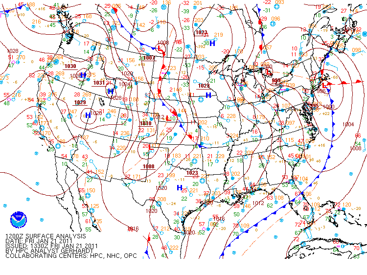
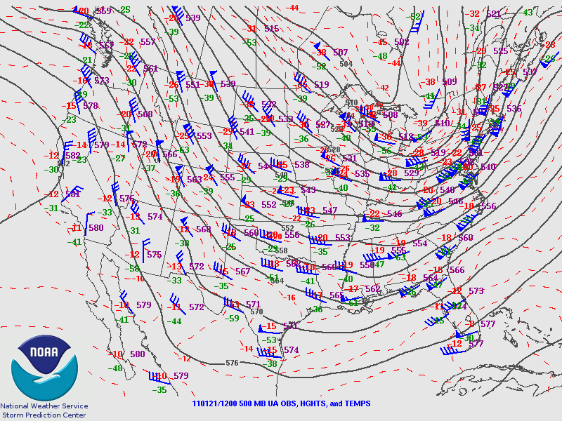
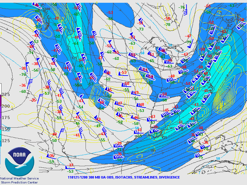
Below are a series of weather maps related to this Arctic outbreak. The image on the left is a surface weather map from 6 AM January 21st that has been analyzed by the Hydrometeorological Prediction Center for fronts and high and low pressures. The Arctic high pressure is clearly centered over parts of the Upper Midwest. The image in the middle shows observations in the middle layers of the atmosphere (500mb) at the same time. The expansive trough over the central and eastern United States reflects a large scale pattern that is conducive to Arctic outbreaks. The image on the right shows observations at the same time from the upper levels of the atmosphere (300mb). The shaded contours are for higher wind speeds and help indicate the jet stream location.
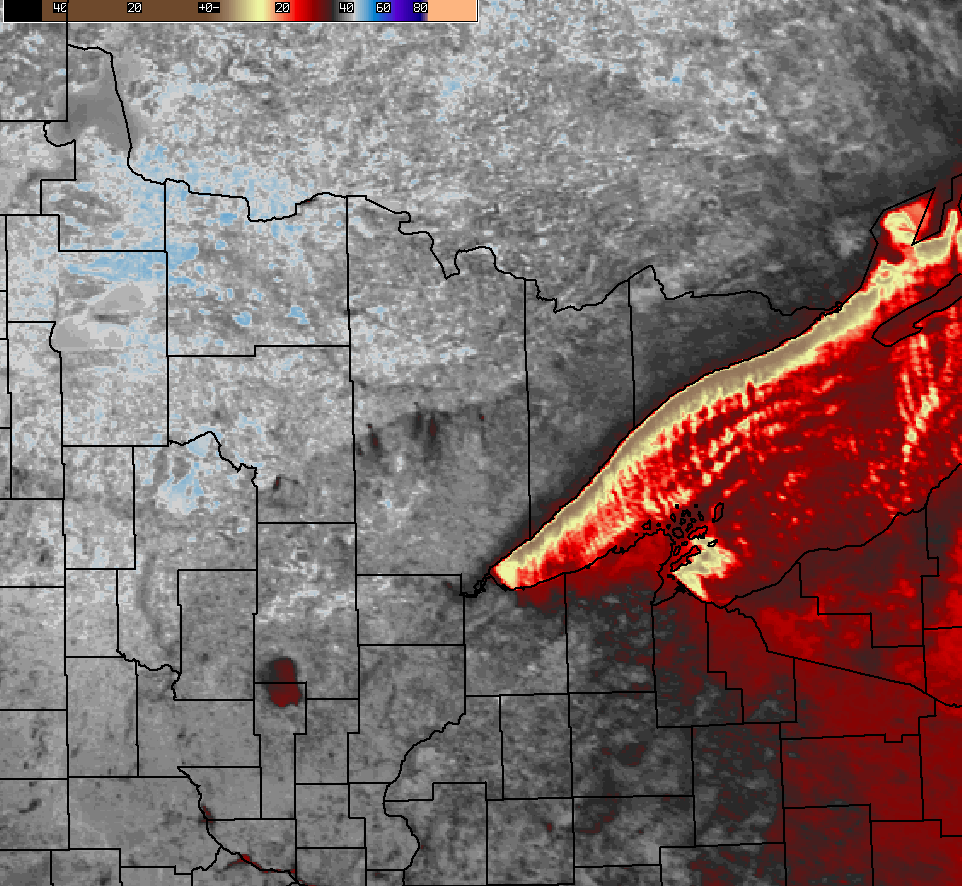
Next is the 1km resolution MODIS infrared (IR) satellite image from 2:41 AM CST January 21st. The color scale used is shown in the upper left hand side of the image. Gray colors are generally where the IR temperatures are -30 Celsius or lower. White colors generally indicate -40C or lower, and light blue -45C or lower. Be careful to note that the infrared temperatures that are sampled by satellites are not necessarily equal to the surface air temperatures. These satellite images are intended to show the patterns and trends in the overall temperature distribution. An infrared satellite will sample the temperature of the radiating surface, whether it happens to be clouds or the Earth.
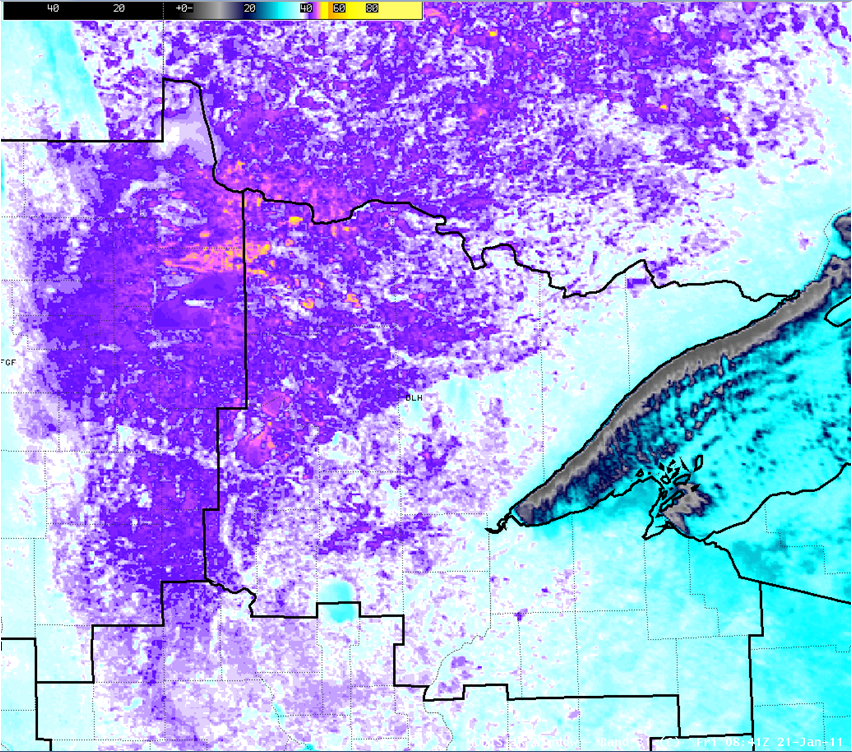
The two images below are the same, but with different color curves. Lake Mille Lacs stands out as a warm spot, while several river valleys feature multiple localized cold spots. The image illustrates the very localized nature of the very coldest spots, and highlights the difficulty of sampling this with the standard observing network.