Overview
|
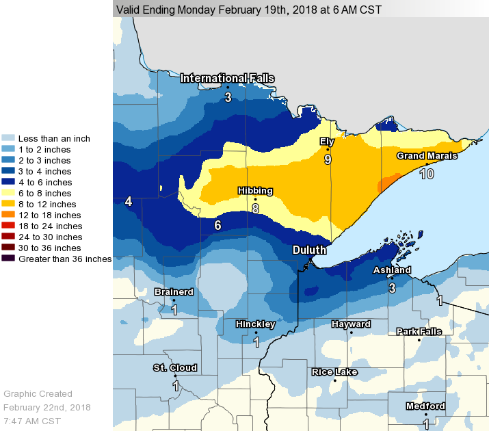
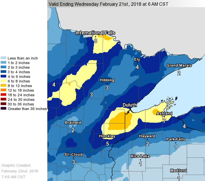
Snow fell off and on across northeast Minnesota and northwestern Wisconsin for three days beginning in the morning of the 18th and lasting through the morning of the 20th. A band of snow developed over northeast Minnesota Sunday morning, the 18th. For this first batch of snow, the main snow was along and north of U. S. Highway 2 in Minnesota where amounts ranged from 4 to 15 inches. The highest amounts were from northern Cass County, across much of Itasca and the rest of the Arrowhead. Another batch of snow developed by Monday morning and the snow continued to fall through the day and night and ended by early Tuesday afternoon. This snow area was mainly from the head of Lake Superior which encompassed Moose Lake and Sturgeon Lake. The snow area then extended east to Wisconsin across northern Douglas County, northern Bayfield County and far northern Ashland Counties. There was also occasional periods of freezing rain over northern Wisconsin. The snowfall map to the right depicts the three day snowfall amounts through 6 am Wednesday, February 21st. The maps below depict the 24 hour snowfall totals for each round of snow. Click image for larger view.
|
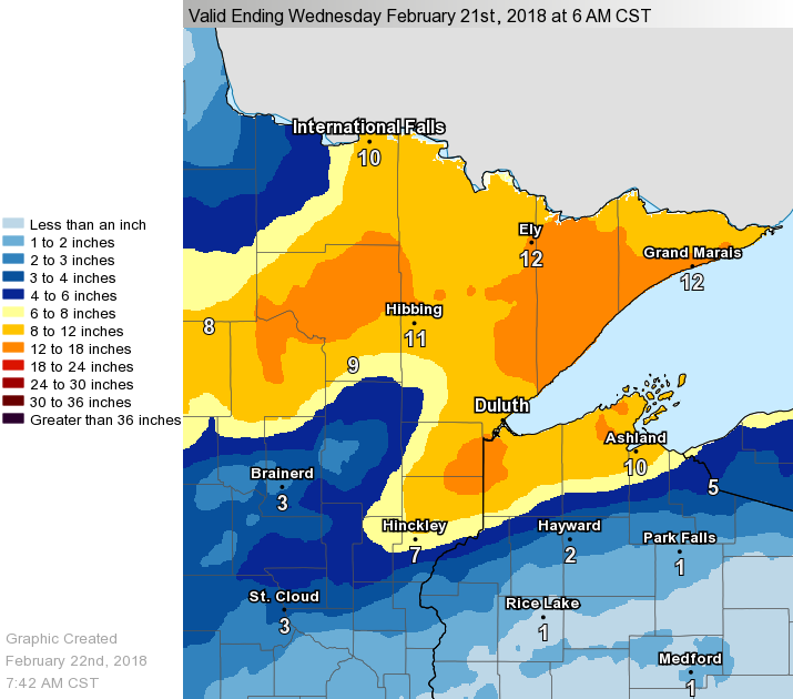 Storm Snowfall Amounts Ending 6 am Wednesday, Feb 21st |
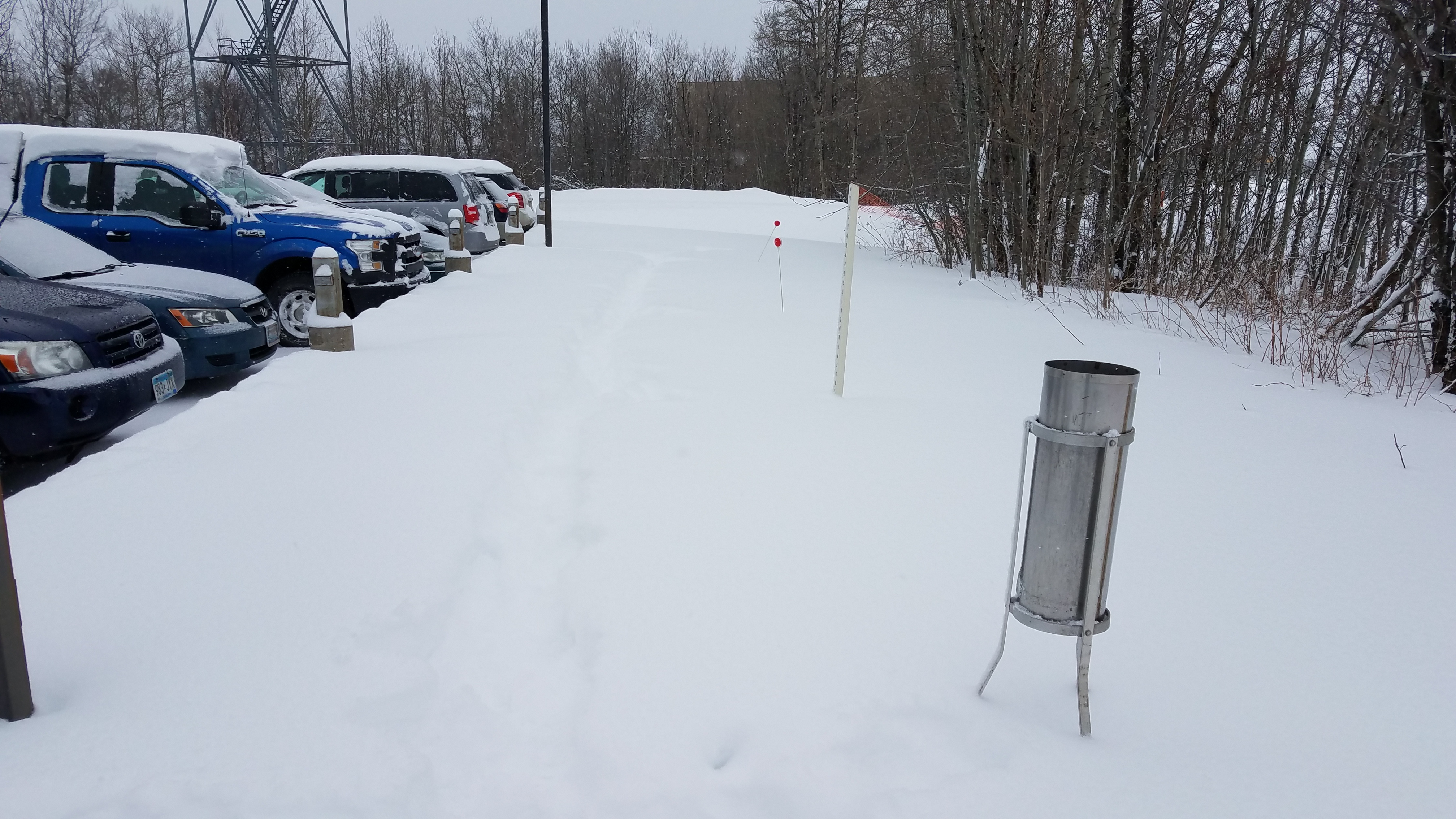 |
| This is the NWS snow field where we take official snow measurements. We finally have a good snow base. |
Storm Reports
856
NOUS43 KDLH 202330
PNSDLH
MNZ010>012-018>021-025-026-033>038-WIZ001>004-006>009-211130-

Public Information Statement
National Weather Service Duluth MN
530 PM CST Tue Feb 20 2018

Preliminary Total Snowfall Reports from Sunday through Tuesday.

INCHES  LOCATION                 ST  COUNTY
------  -----------------------  --  --------------
 14.9    7 NW Two Harbors         MN  LAKE
 14.2    2 ENE Holyoke            MN  CARLTON
 13.5    Ely                      MN  ST. LOUIS
 12.6    2 NW Duluth              MN  ST. LOUIS
 12.0    6 N Knife River          MN  ST. LOUIS
 12.0    Embarrass                MN  ST. LOUIS
 11.7    3 N Amnicon Falls        WI  DOUGLAS
 11.2    Wrenshall                MN  CARLTON
 11.0    Bennett                  WI  DOUGLAS
 10.5    1 SE Oulu                WI  BAYFIELD
  9.9    Duluth NWS               MN  ST. LOUIS
  9.8    3 N Mahtowa              MN  CARLTON
  9.7    2 NE Duluth              MN  ST. LOUIS
  9.5    3 SSW Bruno              MN  PINE
  6.6    3 E Orr                  MN  ST. LOUIS
  6.6    1 W Silver Bay           MN  LAKE
  6.3    1 SE Moose Lake          MN  CARLTON
  4.5    Kettle River             MN  CARLTON
  4.2    International Falls      MN  KOOCHICHING
  3.0    Gile                     WI  IRON

$$
 |
Media use of NWS Web News Stories is encouraged! Please acknowledge the NWS as the source of any news information accessed from this site. |
|