Summary of Blizzard/Heavy Snow
2008 December 13th-15th
|
Northland Storm Snowfall Totals |
Regional Storm Snowfall Totals |
 |
 |
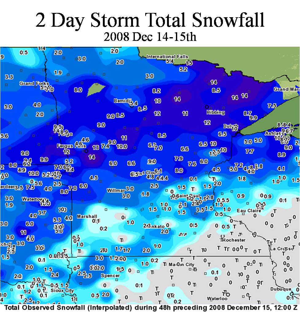
A winter storm moved across the Upper Midwest over the weekend of December 14th, 2008, providing the Northland with its first major snowfall of the season. Heavy snow and very strong winds created blizzard and near blizzard conditions over almost all of the Northland. Over ten inches of snow fell roughly west of a line from Grand Marais through Duluth to Hinckley. East and south of this area snowfall totals ranged from about six to eight inches. The greatest snow amounts of over a foot occurred in the Minnesota Arrowhead along the Iron Range to central Lake County and northward. A maxima of fourteen to over fifteen inches was from about Hibbing to Ely and to Isabella.
Winds over 50 mph were common near Lake Superior in Duluth. These winds caused blizzard conditions of zero visibility in snow and blowing snow. These northeast winds caused huge waves of nearly fifteen feet at the Duluth Entry. The storm was preceded by very mild weather with temperatures in the 30s and 40s on Saturday. Snow began falling in earnest over northeastern Minnesota Saturday evening while rain and freezing rain was common over northwestern Wisconsin and the southern areas of northern Minnesota, such as Hinckley and Pine City. By Sunday all snow was falling, so heavy that it accumulated at a rate of 2 inches per hour. U. S. Highway 2 was closed west of Ashland, WI, due to low visibility and drifting snow.
As the low pressure area responsible for the snow moved east, it swung a cold front through the region. This very strong front caused temperatures to plummet below zero. Monday morning low temperatures were in the single digits and teens below zero. Winds chills were in the 20s and 30s below zero.
More about this event
Read the recap of this storm from the Minnesota State Climatology Office
Crashing Lake Superior waves and spray coated these rocks and rope with ice at Duluth's Canal Park.
NWS photo by Dan Sargent
 |
Media use of NWS Web News Stories is encouraged! Please acknowledge the NWS as the source of any news information accessed from this site. |
 |