Overview
|
A powerful, long duration winter storm brought widespread snowfall amounts of 8 to 24 inches across parts of northeast Minnesota and northwest Wisconsin, with areas around Lake Superior receiving up to 30 inches of snow. A wintry mixture of sleet, freezing rain and snow began Tuesday (December 13th) afternoon and evening, spreading northeast overnight Tuesday night and into Wednesday (December 14th) morning. This first wave of precipitation brought a widespread 6 to 12 inches of snow. We had a break in the snowfall during the day on Wednesday, but it started up again Wednesday night and continued into Thursday (December 15th), bringing another 8-20 inches of snow. This second wave of precipitation was nearly all snow, enhanced by the main upper level low pressure system as it moved close to the area. Lighter snow lingered into Friday and Saturday, December 16th and 17th. A low pressure system developed over eastern Colorado early Tuesday, moved northeast to eastern Nebraska by Wednesday morning, then to east-central Minnesota by Thursday morning, lingering there through Friday before moving off to the northeast Friday night and Saturday. The storm resulted in a long period of poor road conditions, with strong winds causing blowing and drifting snow. There were also widespread power outages, with some people reporting no power for over two days! |
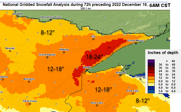 NOHRSC Snowfall Analysis for December 14-16 2022, showing 8-24 inches over the Northland |
|
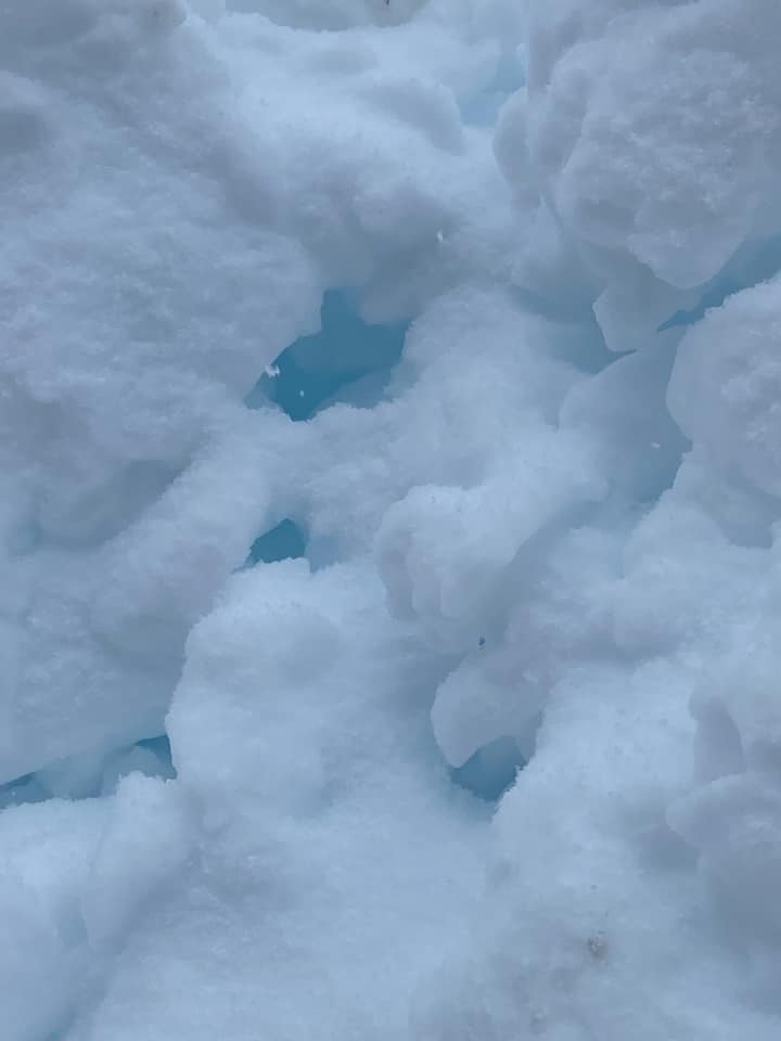
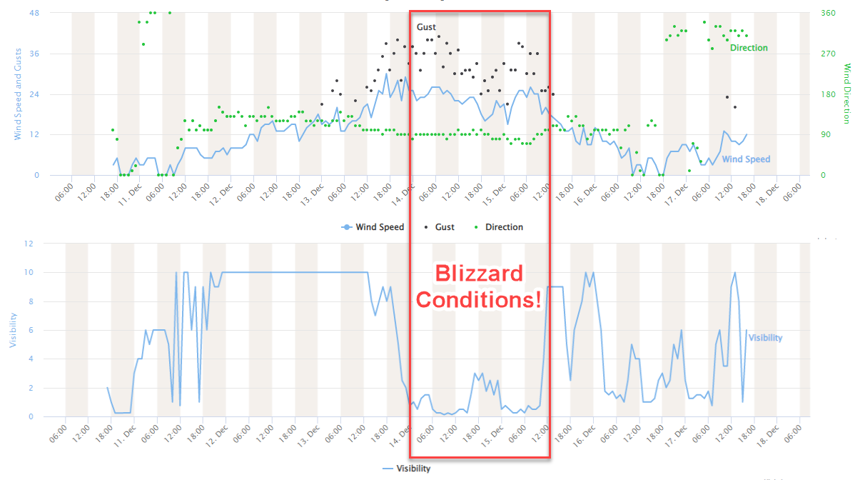
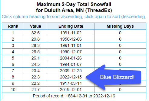
Notable with this storm was how wet and heavy the snow was, with 3-day liquid equivalent values of 1 to 4 inches. The wet quality of this snow, unusual for winter storms in this area, heavily weighed down trees and power lines. The density of the snowpack also exacerbated the quality of snow to absorb the red end of the visible light spectrum, transmitting the blue end, which led to many folks observing a glacier blue color in holes and cracks in the snow as they cleared it. Because of this blue color, as well as the very wet quality of the snowfall, NWS Duluth has taken to referring to this snow as the Blue Blizzard of 2022. |
|
Snow/Ice
Storm reports plotted on a map
PUBLIC INFORMATION STATEMENT
NATIONAL WEATHER SERVICE DULUTH MN
1108 AM CST FRI DEC 16 2022

...STORM TOTAL SNOWFALL REPORTS...
7S HOUR SNOWFALL REPORTS OF 1 INCH OR MORE ENCOMPASSING THE 2022 MID DECEMBER BLIZZARD.

LOCATION                     AMOUNT    TIME/DATE       PROVIDER

...MINNESOTA...

...AITKIN COUNTY...
TAMARACK 2.5 SE              16.5 IN    0700 AM 12/16  COCORAHS
TAMARACK 1.4 SW              14.1 IN    0700 AM 12/16  COCORAHS
7 N MCGREGOR                 16.7 IN    0700 AM 12/16  COCORAHS

...CARLTON COUNTY...
WRENSHALL                    20.9 IN   0800 AM 12/16   UCOOP
WRENSHALL 9.7 SSE            17.1 IN   0700 AM 12/16   COCORAHS
CARLTON 5.6 NE               29.5 IN   0700 AM 12/16   COCORAHS
3 E WRIGHT 2.7 ESE           16.4 IN    0700 AM 12/16  COCORAHS

...CASS COUNTY...
PILLAGER 5.1 N               15.2 IN   0620 AM 12/16   COCORAHS
DEER RIVER 6.5 S             11.5 IN   0800 AM 12/16   COCORAHS
CASS LAKE                    10.9 IN   0800 AM 12/16   COOP
HACKENSACK 5.4 NE            9.6 IN    0800 AM 12/16   COCORAHS
FEDERAL DAM 0.3 S            9.0 IN    0700 AM 12/16   COCORAHS
REMER 11.5 WSW               11.7 IN   0700 AM 12/16   COCORAHS

...COOK COUNTY...
LUTSEN 11.8 N                16.3 IN   0800 AM 12/16   COCORAHS
GRAND MARAIS 4.4 WSW         16.1 IN   0700 AM 12/16   COCORAHS
GRAND MARAIS 4.4 W           16.0 IN   0600 AM 12/16   COCORAHS
10 ESE SEA GULL LAKE         15.8 IN   0800 AM 12/16   BROADCAST MEDIA
GRAND MARAIS 6.6 NW          15.5 IN   0700 AM 12/16   COCORAHS
TOFTE 4.9 NE                 12.5 IN   0700 AM 12/16   COCORAHS
HOVLAND 2.8 WNW              11.8 IN   0730 AM 12/16   COCORAHS
3.7 NE SEA GULL LAKE         8.3 IN    0700 AM 12/16   COOP
GRAND MARAIS 3.6 E           1.5 IN    0700 AM 12/16   COCORAHS
TOFTE 2.1 NE                 1.0 IN    0700 AM 12/16   COCORAHS

...CROW WING COUNTY...
BRAINERD 11.5 E              16.5 IN   0740 AM 12/16   COCORAHS
NISSWA 4.2 ENE               15.8 IN   0800 AM 12/16   COCORAHS
CROSBY 1.1 SW                15.3 IN   0630 AM 12/16   COCORAHS
FORT RIPLEY 0.8 N            13.7 IN   0700 AM 12/16   COCORAHS
BRAINERD 7.7 SSE             12.8 IN   0700 AM 12/16   COCORAHS
TROMMALD 6.1 NW              10.9 IN   0800 AM 12/16   COCORAHS
BRAINERD                     3.5 IN    0700 AM 12/16   COOP

...ITASCA COUNTY...
4 NNW NASHWAUK               19.8 IN   0800 AM 12/16   TRAINED SPOTTER
GRAND RAPIDS 6.2 SSW         19.0 IN   0600 AM 12/16   COCORAHS
GRAND RAPIDS 6.3 N           18.5 IN   0830 AM 12/16   COCORAHS
COLERAINE 0.7 S              18.1 IN   0700 AM 12/16   COCORAHS
GRAND RAPIDS 6.1 N           17.9 IN   0700 AM 12/16   COCORAHS
1 W GRAND RAPIDS             17.5 IN   0706 AM 12/16   TRAINED SPOTTER
COHASSET 1.5 WSW             17.0 IN   0700 AM 12/16   COCORAHS
3 SW COHASSET                17.0 IN   0700 AM 12/16   PUBLIC
12 N GRAND RAPIDS            16.5 IN   0800 AM 12/16   CO-OP OBSERVER
BOVEY 13.4 N                 15.7 IN   0649 AM 12/16   COCORAHS
SWAN RIVER 0.6 W             14.5 IN   0630 AM 12/16   COCORAHS
BIGFORK 7.3 SW               14.4 IN   0700 AM 12/16   COCORAHS
MARCELL 0.7 NNW              13.7 IN   0830 AM 12/16   COCORAHS
DEER RIVER 3.7 W             12.7 IN   0800 AM 12/16   COCORAHS
GRAND RAPIDS 12 N            11.5 IN   0630 AM 12/16   COOP
NORTHOME 3 S                 10.5 IN   0700 AM 12/16   COOP

...KOOCHICHING COUNTY...
INTERNATIONAL FALLS 5.1 SSW  10.5 IN   0700 AM 12/16   COCORAHS
BIG FALLS 1.0 N              9.7 IN    0800 AM 12/16   COCORAHS
INTERNATIONAL FALLS 0.6 NW   8.8 IN    0700 AM 12/16   COCORAHS

...LAKE COUNTY...
FINLAND 0.8 NNE              35.5 IN   0700 AM 12/16   COCORAHS
TWO HARBORS 3.6 WNW          30.0 IN   0700 AM 12/16   COCORAHS
TWO HARBORS 19.8 N           25.0 IN   0700 AM 12/16   COCORAHS
TWO HARBORS 2.1 NW           25.0 IN   0700 AM 12/16   COCORAHS
WOLF RIDGE                   24.3 IN   0700 AM 12/16   COOP
1 W SILVER BAY               22.6 IN   0800 AM 12/16   TRAINED SPOTTER
ELY 25 E                     14.3 IN   1000 AM 12/16   COOP
TWO HARBORS 0.4 ESE          3.2 IN    0800 AM 12/16   COCORAHS
TWO HARBORS                  2.3 IN    0700 AM 12/16   COOP

...PINE COUNTY...
STURGEON LAKE 7.5 ESE        18.3 IN   0600 AM 12/16   COCORAHS
PINE CITY 0.7 SSW            10.5 IN   0700 AM 12/16   COCORAHS

...ST. LOUIS COUNTY...
DULUTH 7.9 SW                28.5 IN   0900 AM 12/16   COCORAHS
NWS DULUTH                   24.2 IN   0600 AM 12/16   COOP
BRIMSON 2.0 S                23.8 IN   0800 AM 12/16   COCORAHS
DULUTH 11.8 NNE              23.0 IN   0730 AM 12/16   COCORAHS
4 NNW FRENCH RIVER           21.0 IN   0800 AM 12/16   COCORAHS
1 SSE HIBBING                19.4 IN   0800 AM 12/16   TRAINED SPOTTER
DULUTH 4.6 NE                18.8 IN   0740 AM 12/16   COCORAHS
CHISHOLM 0.7 NW              18.6 IN   0630 AM 12/16   COCORAHS
IRON JUNCTION 3.4 NNW        18.5 IN   0800 AM 12/16   COCORAHS
HIBBING 11.6 SSW             17.9 IN   0700 AM 12/16   COCORAHS
EMBARRASS                    17.5 IN   0600 AM 12/16   COOP
DULUTH 17.6 NNW              17.5 IN   0700 AM 12/16   COCORAHS
DULUTH 1.4 NNW               16.7 IN   0811 AM 12/16   COCORAHS
3.8 S TOWER                  16.4 IN   0730 AM 12/16   COOP
CANYON 4.6 NNE               16.3 IN   0715 AM 12/16   COCORAHS
5.1 N FLOODWOOD              15.5 IN   0730 AM 12/16   COOP
BIWABIK 2.9 NNE              14.8 IN   0800 AM 12/16   COCORAHS
WRIGHT 9.2 NNE               14.7 IN   0700 AM 12/16   COCORAHS
DULUTH 3.0 NE                14.5 IN   0730 AM 12/16   COCORAHS
2 SSW ELY                    14.3 IN   0810 AM 12/16   TRAINED SPOTTER
DULUTH 15.4 NNW              14.2 IN   0700 AM 12/16   COCORAHS
ELY INTL WOLF CENTER         13.5 IN   0800 AM 12/16   COOP
ELY 0.9 WNW                  13.4 IN   0700 AM 12/16   COCORAHS
ORR 3 E                      13.0 IN   0600 AM 12/16   COOP
CELINA 2 E                   11.0 IN   0900 AM 12/16   COOP
KABETOGAMA                   10.2 IN   0700 AM 12/16   COOP
KABETOGAMA 0.7 SSW           9.9 IN    0700 AM 12/16   COCORAHS
COTTON                       9.5 IN    0600 AM 12/16   COOP
COOK 8NE                     8.7 IN    0600 AM 12/16   COOP
DULUTH 2.9 NE                8.3 IN    0800 AM 12/16   COCORAHS
DULUTH 1.2 SE                4.5 IN    0600 AM 12/16   COCORAHS

...WISCONSIN...

...ASHLAND COUNTY...
ASHLAND 3 S                  10.5 IN   0800 AM 12/16   COOP
ODANAH 1.6 E                 5.5 IN    0700 AM 12/16   COCORAHS

...BAYFIELD COUNTY...
IRON RIVER 5.0 SSE           25.0 IN   0700 AM 12/16   COCORAHS
BAYFIELD 5.1 NNW             19.6 IN   0730 AM 12/16   COCORAHS
ASHLAND 9.8 W                17.1 IN   0600 AM 12/16   COCORAHS
MASON 11.5 WNW               15.6 IN   0800 AM 12/16   COCORAHS
IRON RIVER 5.2 ESE           15.5 IN   0648 AM 12/16   COCORAHS
CABLE 10.2 ENE               14.4 IN   0800 AM 12/16   COCORAHS
MELLEN 18.6 SW               13.9 IN   0715 AM 12/16   COCORAHS
CLAM LAKE 4W                 13.9 IN   0715 AM 12/16   COOP
BAYFIELD 2.6 WSW             13.1 IN   0730 AM 12/16   COCORAHS
5 S HERBSTER                 10.5 IN   0734 AM 12/16   TRAINED SPOTTER
BAYFIELD 1.7 SW              10.2 IN   0700 AM 12/16   COCORAHS
BAYFIELD FISH HATCHERY       8.8 IN    0800 AM 12/16   COOP
WASHBURN 0.8 N               1.0 IN    0700 AM 12/16   COCORAHS

...BURNETT COUNTY...
SPOONER 10.6 WNW             15.0 IN   0900 AM 12/16   COCORAHS
OAKLAND 9.0 ENE              13.7 IN   0700 AM 12/16   COCORAHS
GRANTSBURG 0.6 SSW           11.5 IN   0700 AM 12/16   COCORAHS
7 SW HERTEL                  10.9 IN   0700 AM 12/16   COCORAHS
GRANTSBURG 0.6 SW (KWIGRANT1 9.2 IN    0734 AM 12/16   COCORAHS

...DOUGLAS COUNTY...
SUPERIOR 14.8 S              24.0 IN   0700 AM 12/16   COCORAHS
SOLON SPRINGS 1.2 W          20.9 IN   0700 AM 12/16   COCORAHS
COZY CORNER                  20.5 IN   0800 AM 12/16   COCORAHS
POPLAR 2.0 E                 17.3 IN   0700 AM 12/16   COCORAHS
POPLAR 7.4 SSW               16.0 IN   0700 AM 12/16   COCORAHS
SUPERIOR 2.0 WNW             8.5 IN    0730 AM 12/16   COCORAHS
3 N AMNICON FALLS S.P.       8.3 IN    0800 AM 12/16   TRAINED SPOTTER
SUPERIOR 3.7 WNW             4.9 IN    0700 AM 12/16   COCORAHS

...IRON COUNTY...
MERCER 0.4 N                 9.5 IN    0800 AM 12/16   COCORAHS
SAXON 3.8 W                  9.1 IN    0630 AM 12/16   COCORAHS
PENCE 0.1 E                  7.5 IN    0600 AM 12/16   COCORAHS
MERCER 7.0 NNE               6.8 IN    0700 AM 12/16   COCORAHS
HURLEY                       5.0 IN    0800 AM 12/16   COOP

...PRICE COUNTY...
BUTTERNUT 3 SW               13.0 IN   0600 AM 12/16   COOP
BUTTERNUT 5.9 SW             12.9 IN   0700 AM 12/16   COCORAHS
3 W PHILLIPS                 11.8 IN   0800 AM 12/16   PUBLIC
PHILLIPS 1.3 S               11.7 IN   0600 AM 12/16   COCORAHS
PHILLIPS 0.4 SSW             11.2 IN   0800 AM 12/16   COCORAHS
BRANTWOOD 7.4 S              10.8 IN   0400 AM 12/16   COCORAHS
BRANTWOOD 2.5 S              8.5 IN    0700 AM 12/16   COCORAHS

...SAWYER COUNTY...
HAYWARD 4.4 SSE              16.9 IN   0700 AM 12/16   COCORAHS
HAYWARD 9.2 NNE              13.8 IN   0700 AM 12/16   COCORAHS
HAYWARD 9.7 NE               13.6 IN   0900 AM 12/16   COCORAHS

...WASHBURN COUNTY...
SHELL LAKE 4.3 SW            16.3 IN   0744 AM 12/16   COCORAHS
SARONA 6.8 ENE               12.6 IN   0800 AM 12/16   COCORAHS
SARONA 4.5 NNE               14.1 IN   0800 AM 12/16   COCORAHS
2.0 SE SPOONER               5.0 IN    0700 AM 12/16   UCOOP

...MARITIME STATIONS...
SUPERIOR 3.7 WNW             4.9 IN    0745 AM 12/16   COCORAHS
SUPERIOR 2 ENE               4.0 IN    1158 PM 12/15   COOP

OBSERVATIONS ARE COLLECTED FROM A VARIETY OF SOURCES WITH VARYING
EQUIPMENT AND EXPOSURES. WE THANK ALL VOLUNTEER WEATHER OBSERVERS
FOR THEIR DEDICATION. NOT ALL DATA LISTED ARE CONSIDERED OFFICIAL.
Media
Blue Snow photos, and other snow statistics!
 |
 |
 |
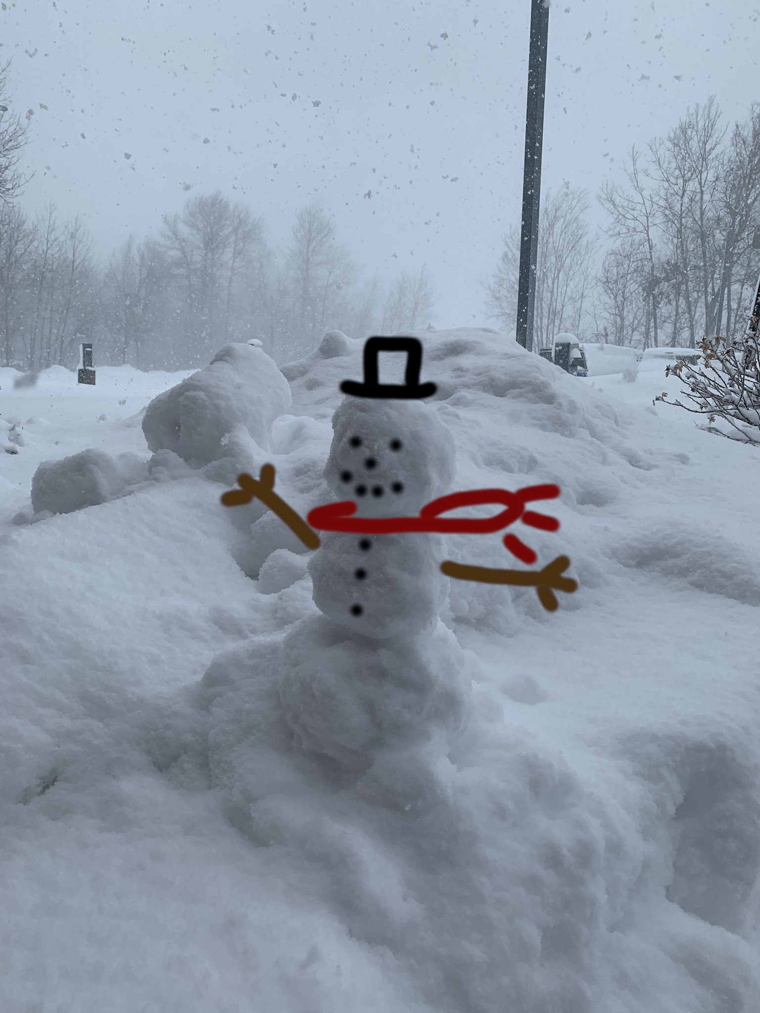
| Snowman at NWS Duluth |
Blue Snow!
(source: Ali Marie) |
More blue snow (source: Taryn Buckner) |
 |
 |
 |
| 5 people slept at NWS Duluth overnight Wednesday night to ensure we were well staffed. Two of these stayed Tuesday night, as well! | Blizzard conditions were found at the Duluth Airport 6am-2pm Wednesday, and again 3am to 9 am Thursday. (KDLH ASOS) |
48 hour snowfall statistics -8th largest snowstorm! |
 |
 |
 |
| More Blue Snow! (source: Tammy Sable) |
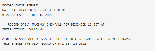
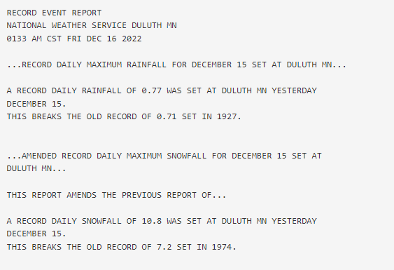
Record daily snowfall of 5.5 inches set at International Falls | Record daily snowfall 10.8 inches and rainfall 0.77 inches at Duluth, MN (NWS Duluth COOP report) |
Radar
Radar loops from the storm, mosaics of multiple radars. More information
 |
 |
|
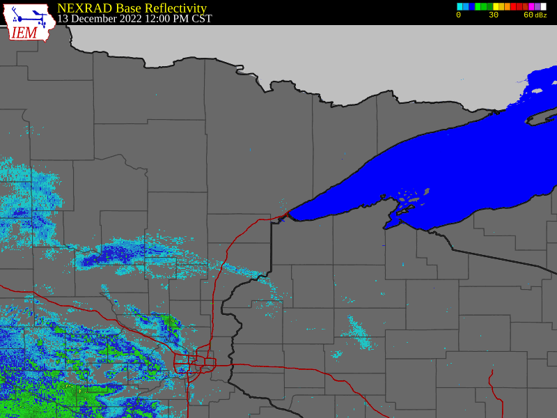
Radar Loop for our first wave of precipitation
Noon Tuesday December 13th until 7pm Wednesday December 14th
(courtesy Iowa Environmental Mesonet)
|
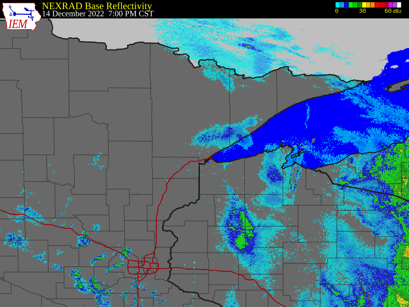
Radar Loop for the second wave of snow
7pm Wednesday December 14th to 2pm Thursday, December 15th.
(courtesy Iowa Environmental Mesonet)
|
 |
 |
|
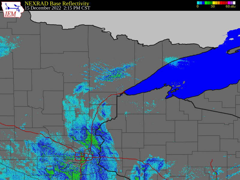
Radar Loop for lingering light-moderate snow
2pm Thursday, December 15th to 6pm Friday December 16th
(courtesy Iowa Environmental Mesonet)
|
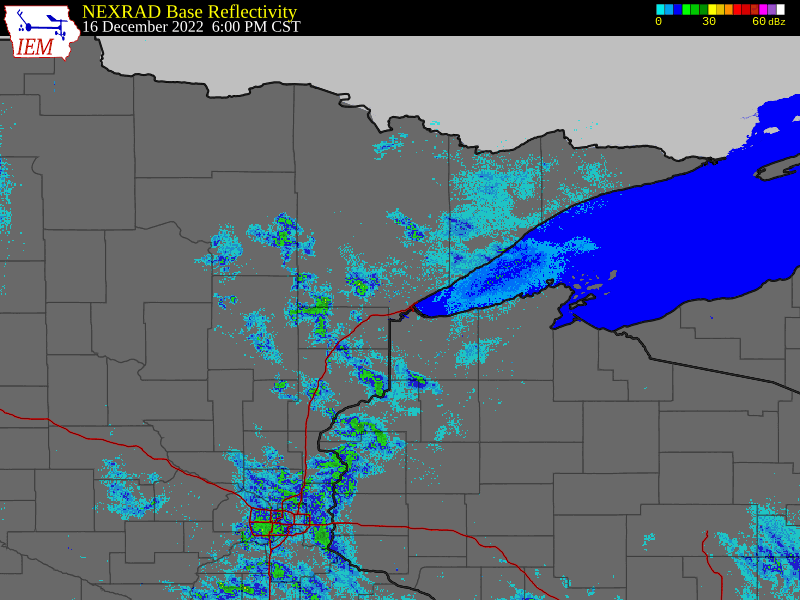
Radar loop 6pm Friday, December 16th through 6pm Saturday December 17th
(courtesy Iowa Environmental Mesonet)
|
Environment
Insert synoptic summary.
 |
 |
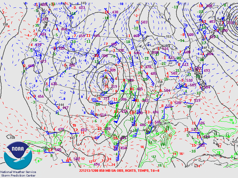 |
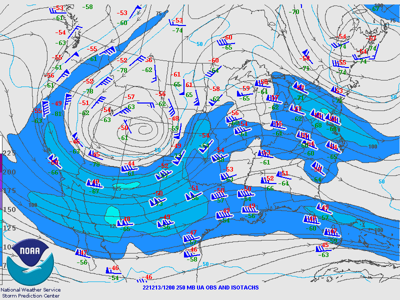
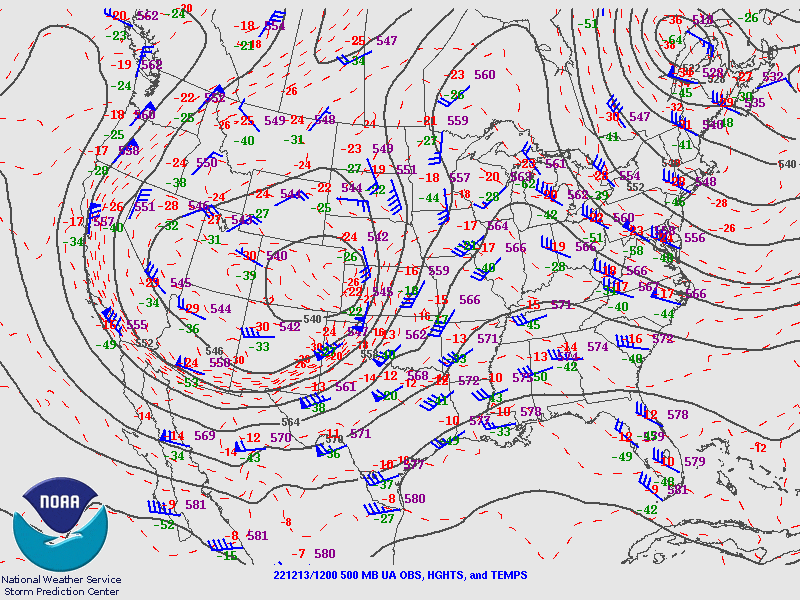
| Figure 1: 250 hPa SPC analysis | Figure 2: 500 hPa SPC analysis | Figure 3: 850 hPa SPC mesoanalysis |
 |
 |
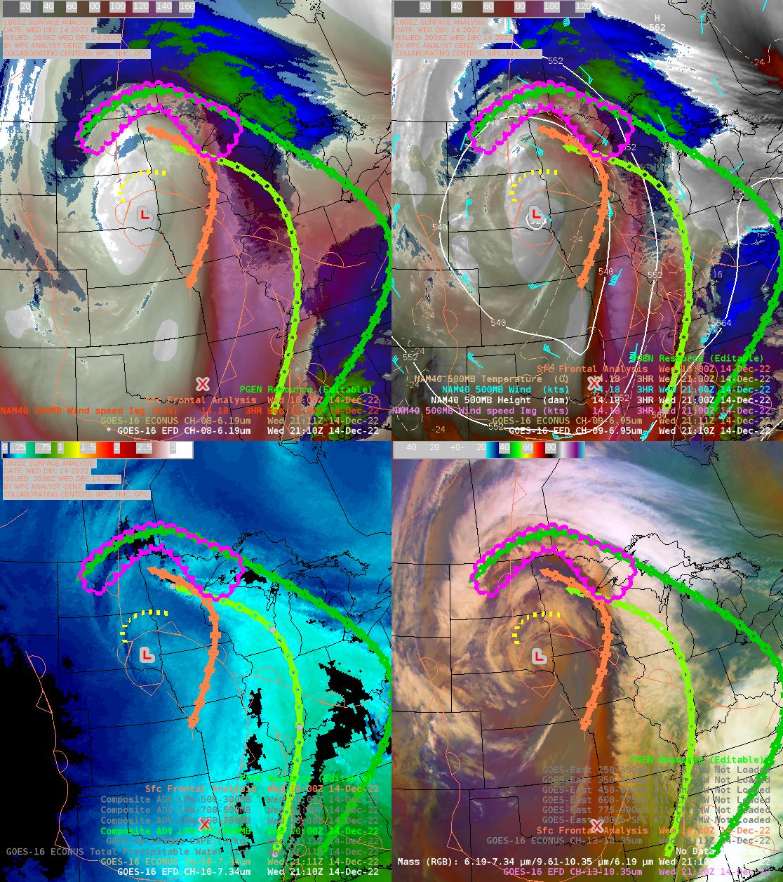 |
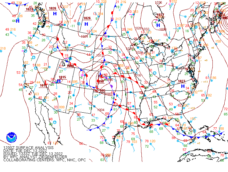
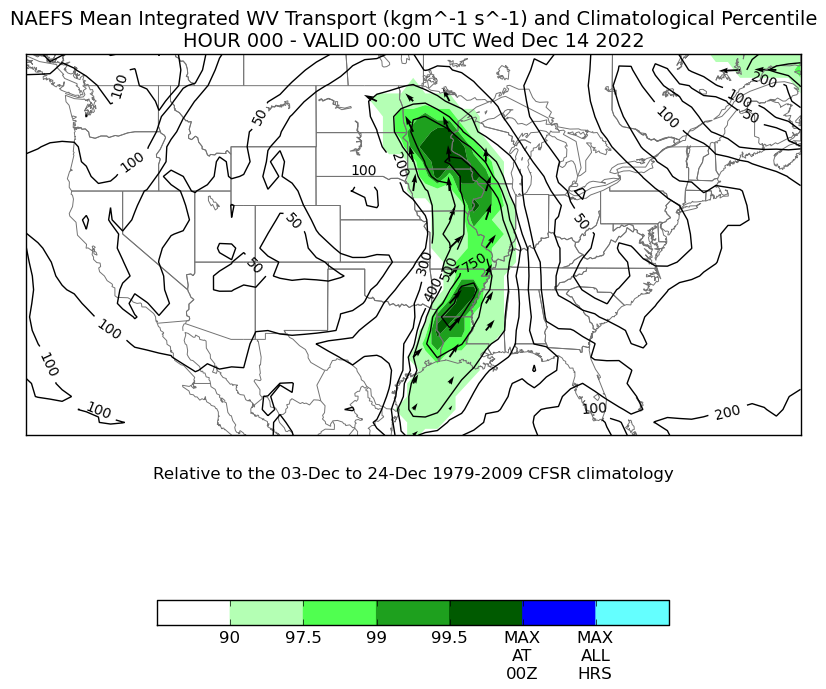
| Figure 4: Surface analysis | Figure 5: NAEFS Mean Integrated Water Transport 6PM Tuesday evening (forecast model) | Figure 6: A 4 panel of satellite imagery. Upper left: Upper Level Water Vapor with 300MB wind speeds. Upper right: Mid Level Water Vapor with 500mb height and winds. Lower right: Air Mass Satellite Imagery Lower left: Advected Layer Precipitable Water Imagery. On all 4 images, position of upper low (red L), Low level flow in orange, mid and upper level flow in light and medium green, respectively |
Additional environmental data.
 |
 |
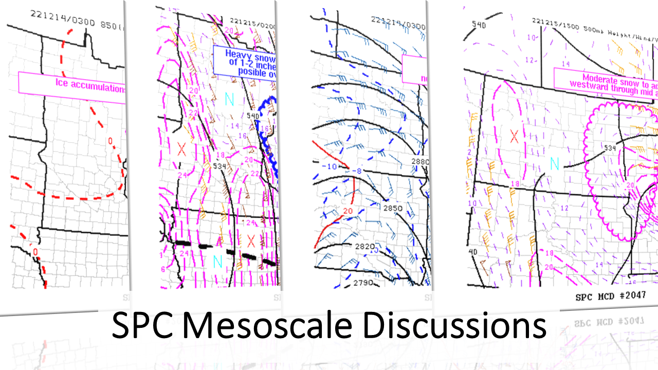 |
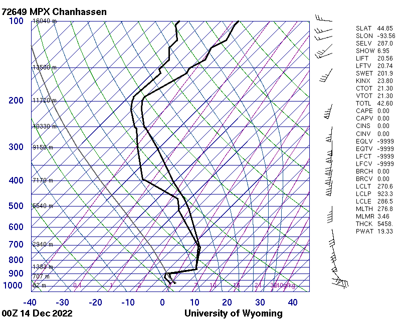
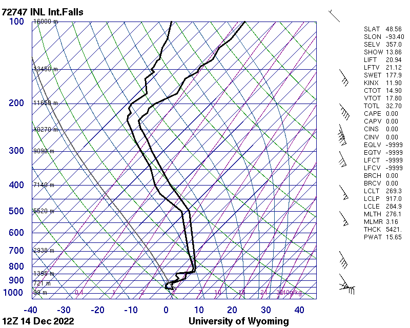
| Figure 7: MPX Chanhassen sounding from 6 PM December 13 2022 showing 19.33mm/0.75 in of Precipitable Water, a significantly above normal value. | Figure 8: INL International Falls sounding from 6 AM December 14 2022, showing 15.65mm/0.61 in of Precipitable Water, also significantly above normal | Figure 9: Numerous SPC Mesoscale Discussions were issued for this storm: 623 PM Tue Dec 13 1202 AM Wed Dec 14 406 AM Wed Dec 14 930 PM Wed Dec 14 1046 AM Thu Dec 15 |
Other environmental information and links:
A discussion of this storm from the Satellite Liaison Blog Note: discusses much of the central CONUS, not just the Northland
 |
Media use of NWS Web News Stories is encouraged! Please acknowledge the NWS as the source of any news information accessed from this site. |
|

