Overview
A strong area of low pressure across the Northern Plains lifted a warm front across the Northland on Memorial Day morning. Showers and storms moved through during the morning hours with the atmosphere recovering during the afternoon hours. A few of the storms were severe during the morning and produced small hail and tree damage. An arc of thunderstorms developed across southwestern Minnesota and adjacent areas of Nebraska, South Dakota and Iowa by the mid-afternoon hours and moved to the northeast and across the Northland for the late afternoon and evening hours. These storms were much stronger and contained very strong winds that produced widespread damage across the region. Additionally, there were a few embedded tornadoes with the storms with the strongest tornadoes producing EF-1 damage in the Deer River and Hinckley areas.
Tornadoes:
|
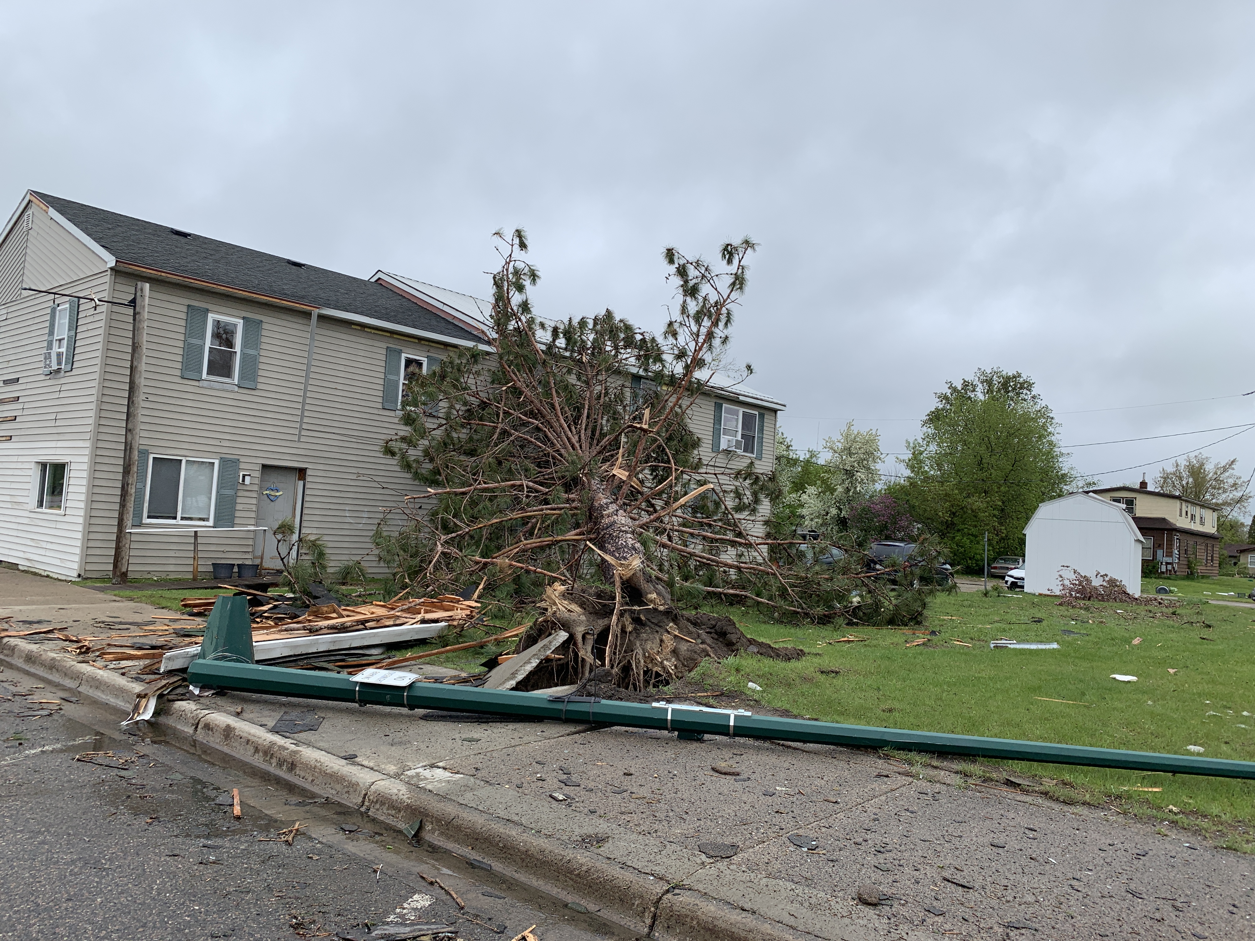
Tornado - Poplar Township, MN
|
||||||||||||||||
|
Tornado - Cohasset, MN
|
||||||||||||||||
|
Tornado - Deer River, MN
|
||||||||||||||||
|
Tornado - Hinckley, MN
|
||||||||||||||||
The Enhanced Fujita (EF) Scale classifies tornadoes into the following categories:
| EF0 Weak 65-85 mph |
EF1 Moderate 86-110 mph |
EF2 Significant 111-135 mph |
EF3 Severe 136-165 mph |
EF4 Extreme 166-200 mph |
EF5 Catastrophic 200+ mph |
 |
|||||
Photos & Video
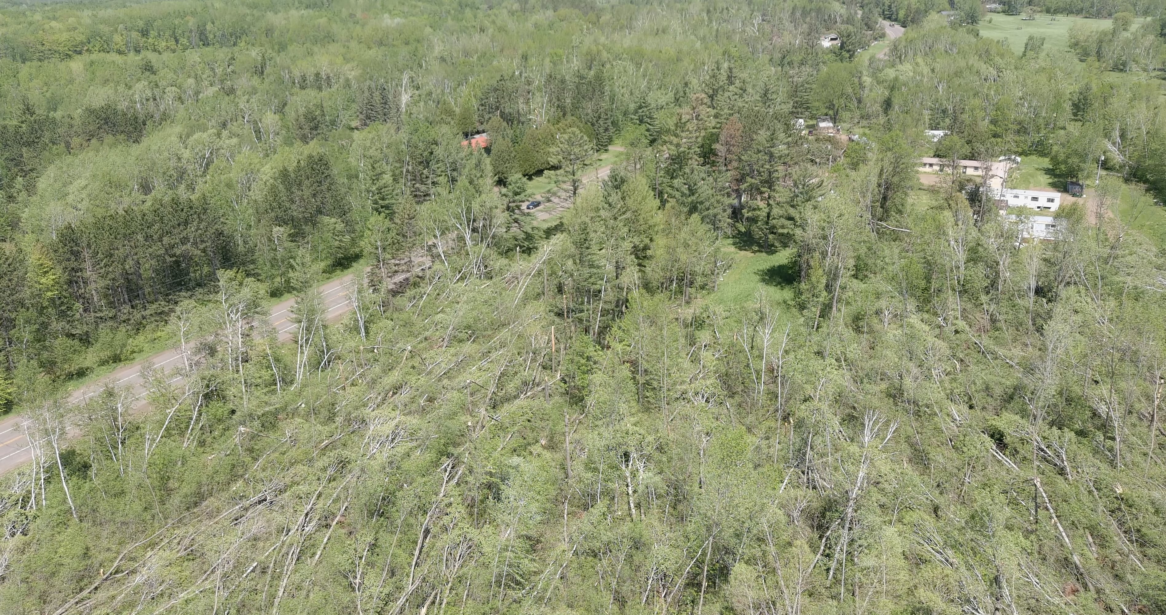
Poplar Township
 |
 |
 |
 |
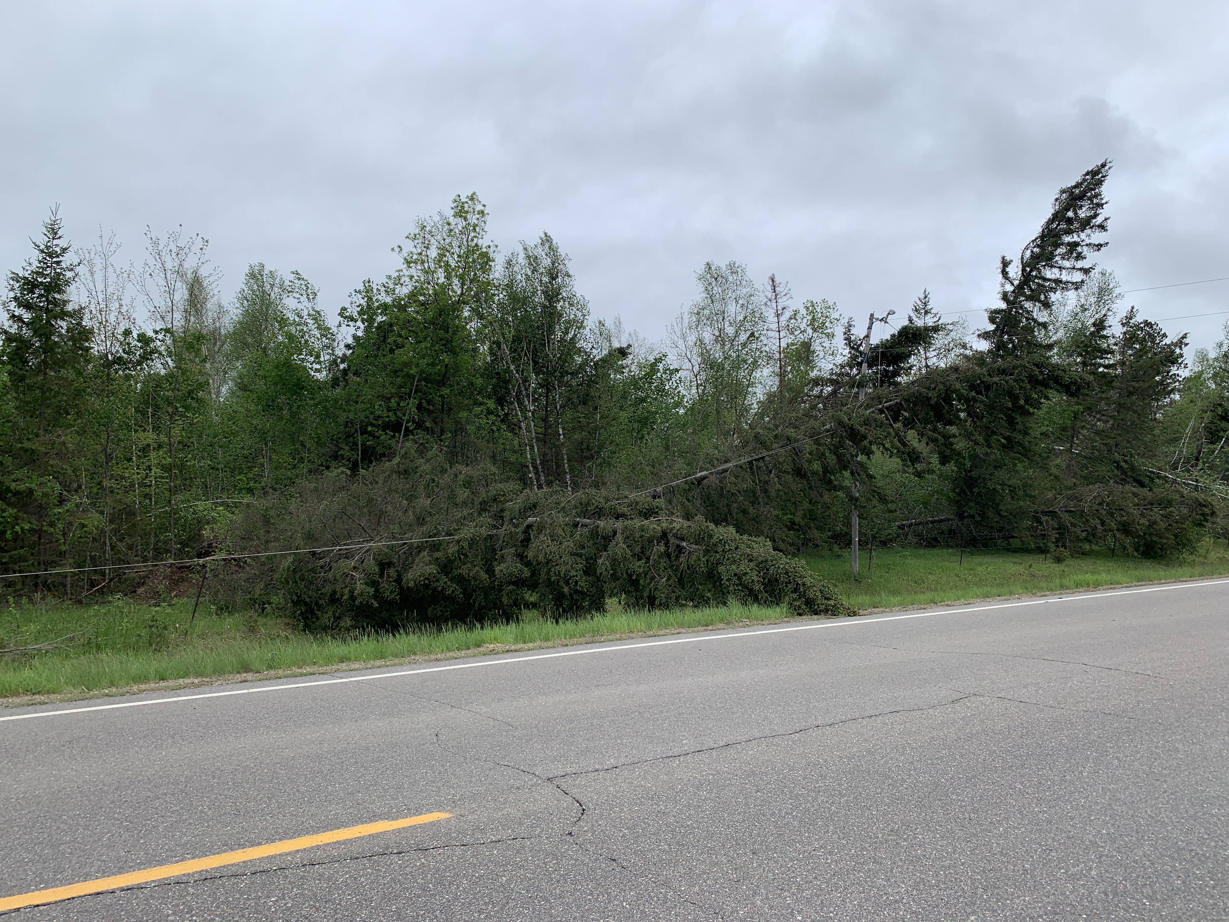
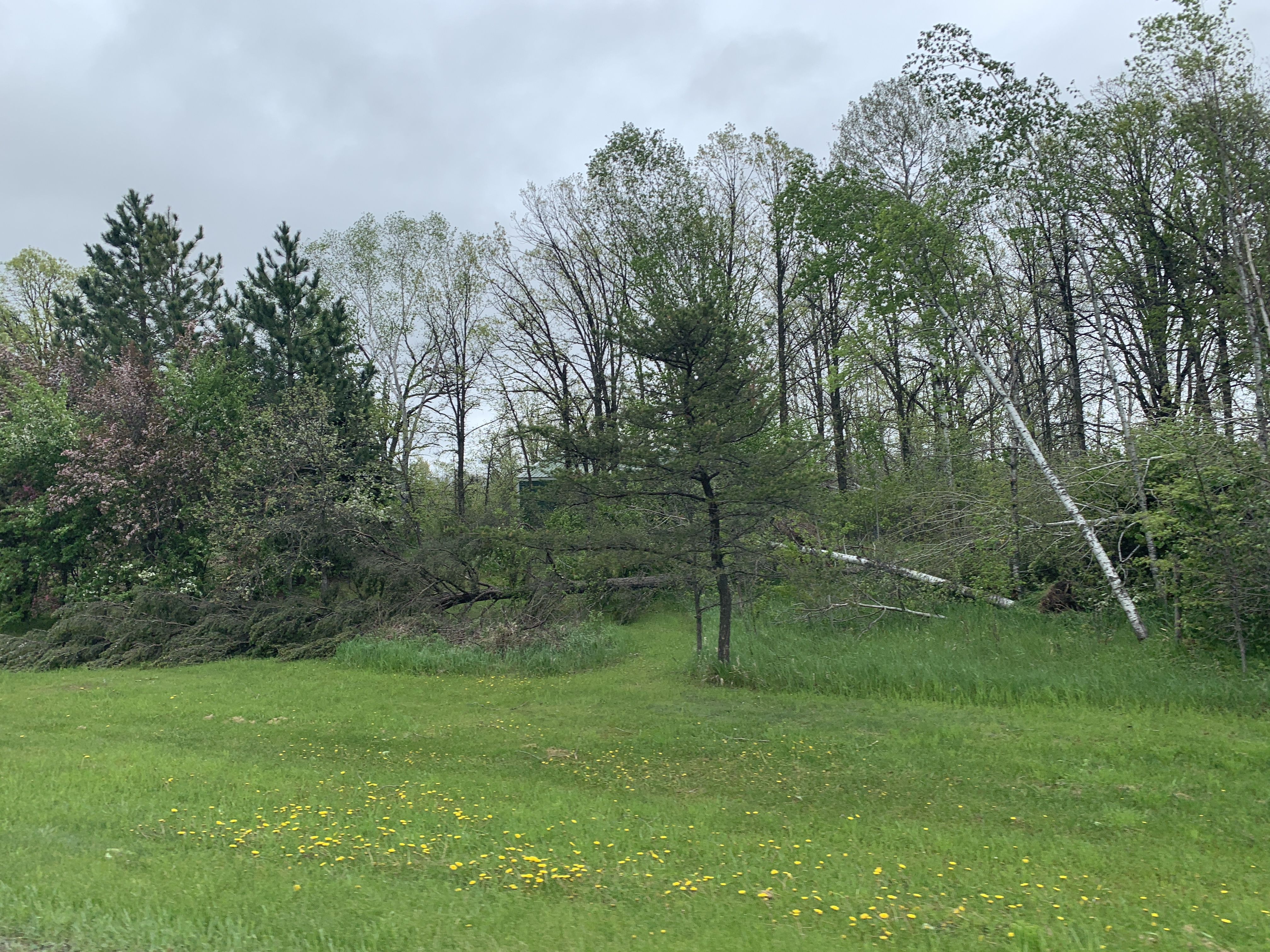
| Tree damage along CR 23 (NWS Duluth) |
Tree damage along CR 23 (NWS Duluth) |
Tree damage along CR 23 (NWS Duluth) |
Tree damage along CR 23 (NWS Duluth) |
 |
 |
 |
 |
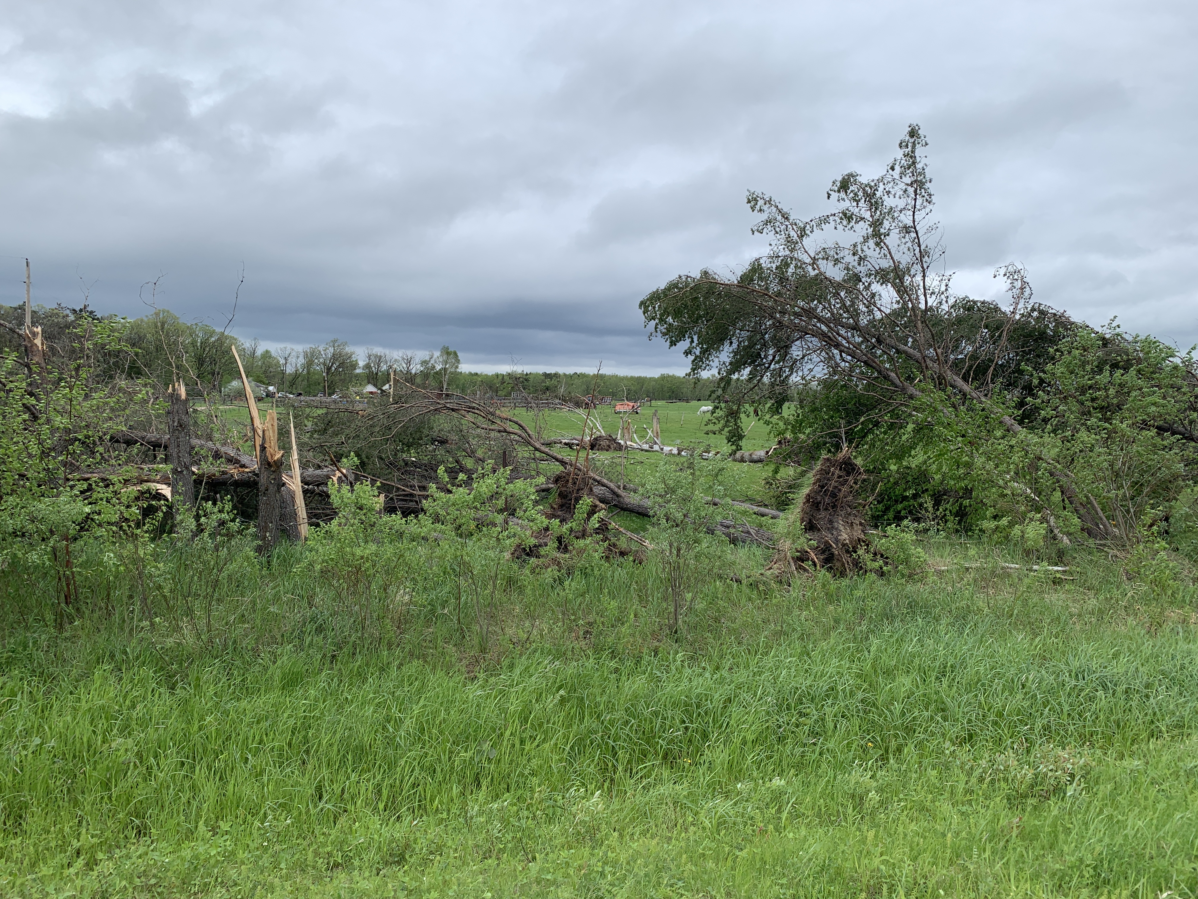
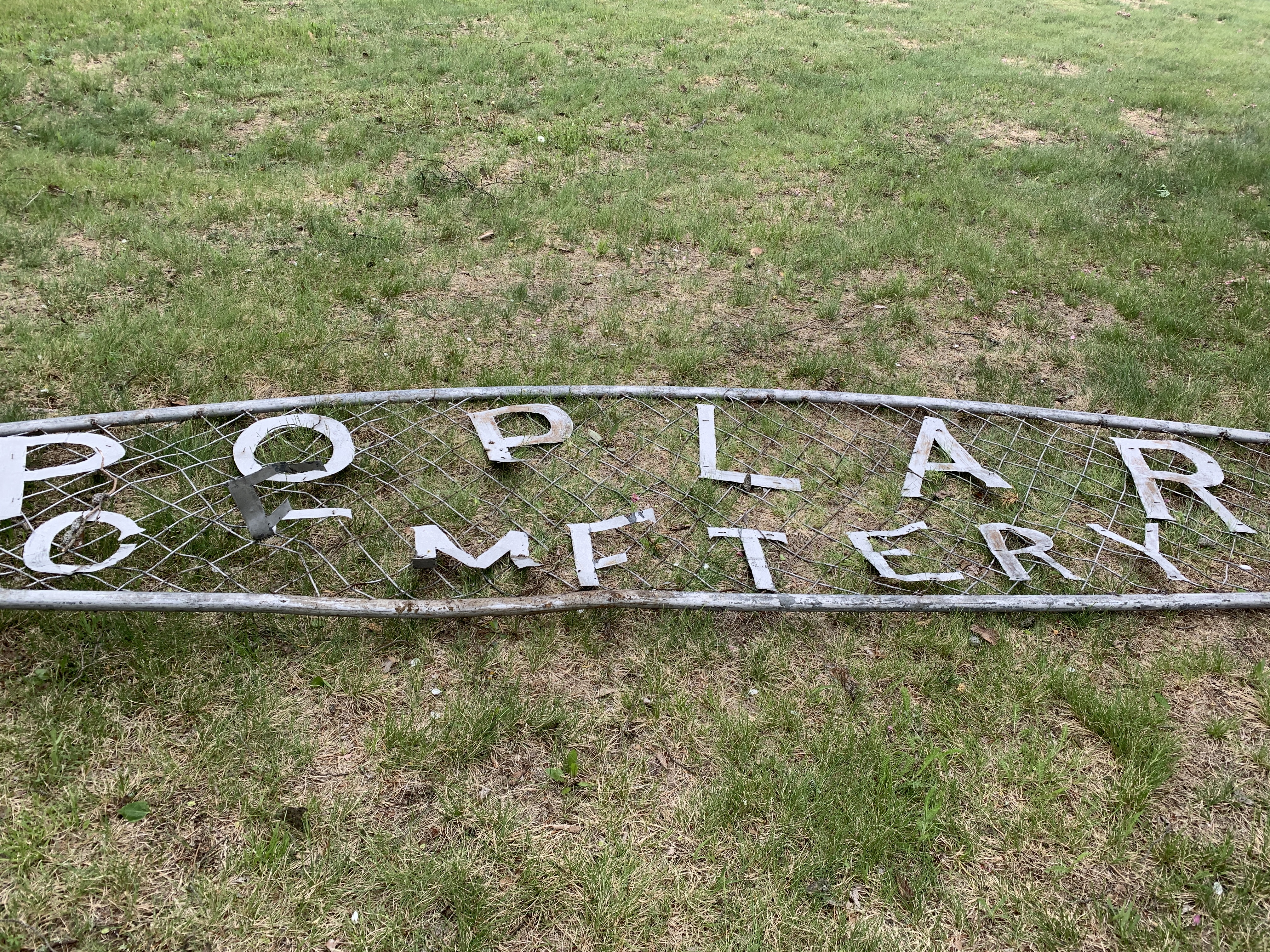
| Damaged sign at the Poplar Cemetery (NWS Duluth) |
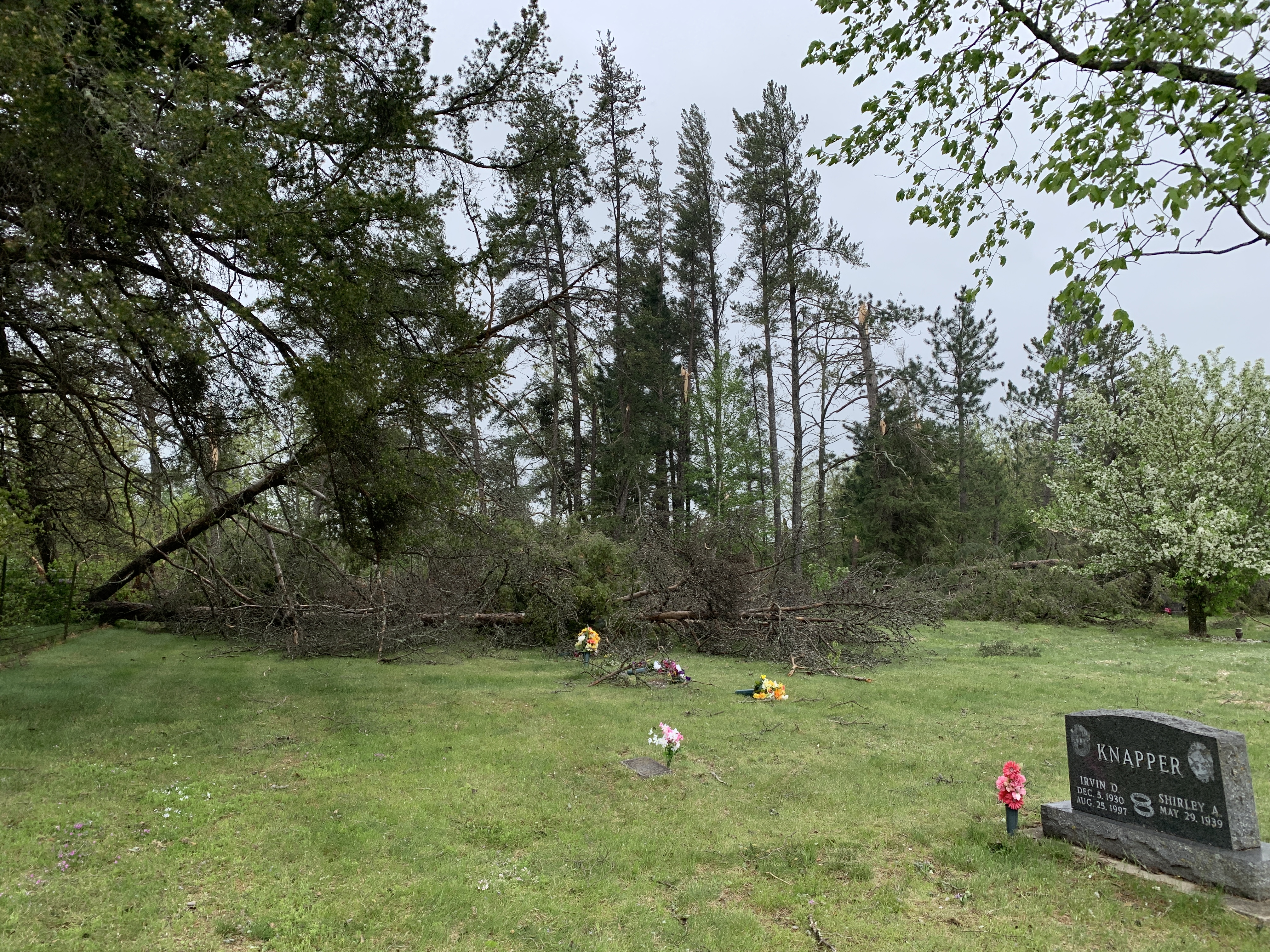
Tree damage at the Poplar Cemetery (NWS Duluth) |
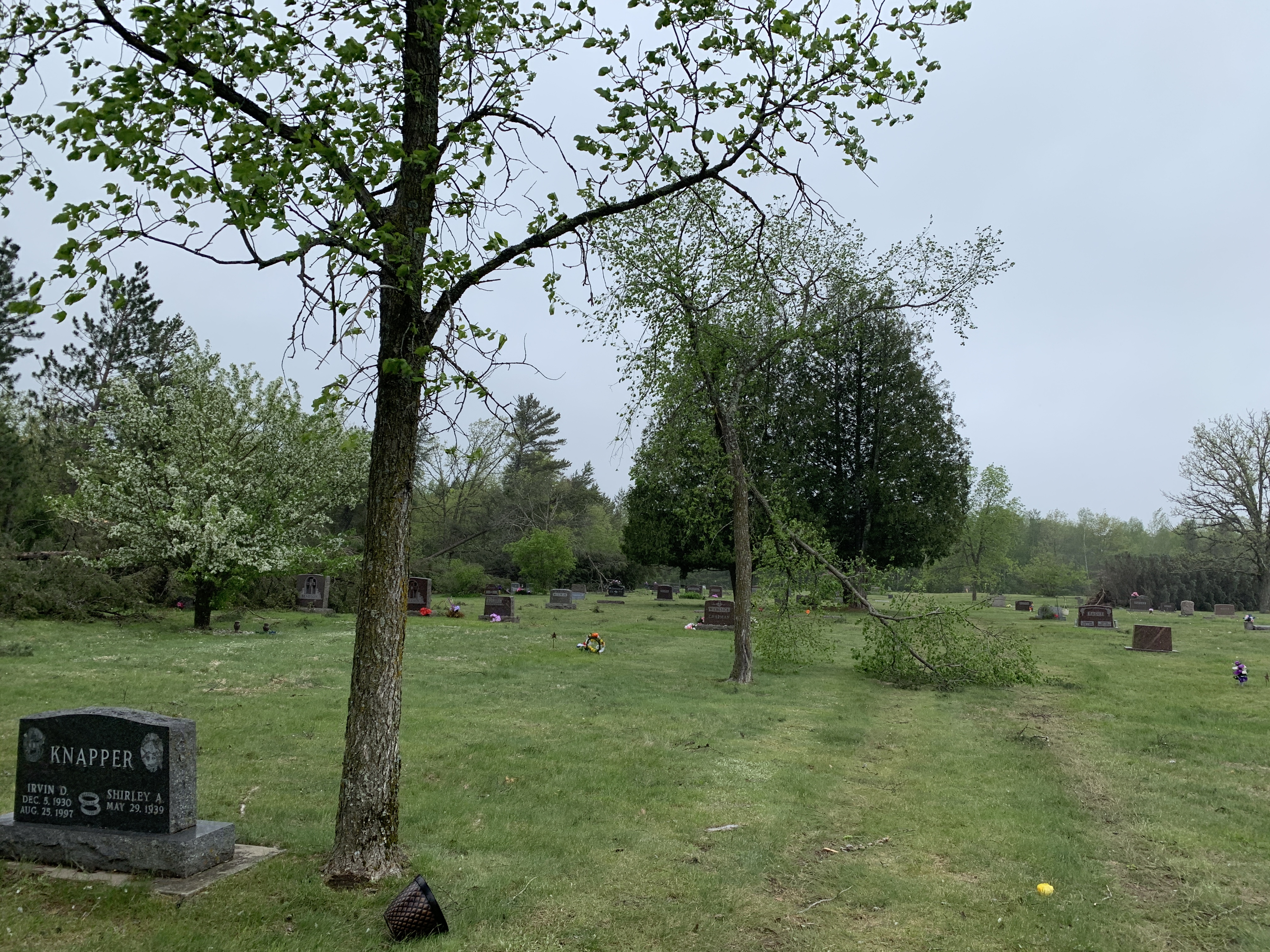
Tree damage at the Poplar Cemetery (NWS Duluth) |
Downed power lines along CR 30 (NWS Duluth) |
 |
 |
 |
|
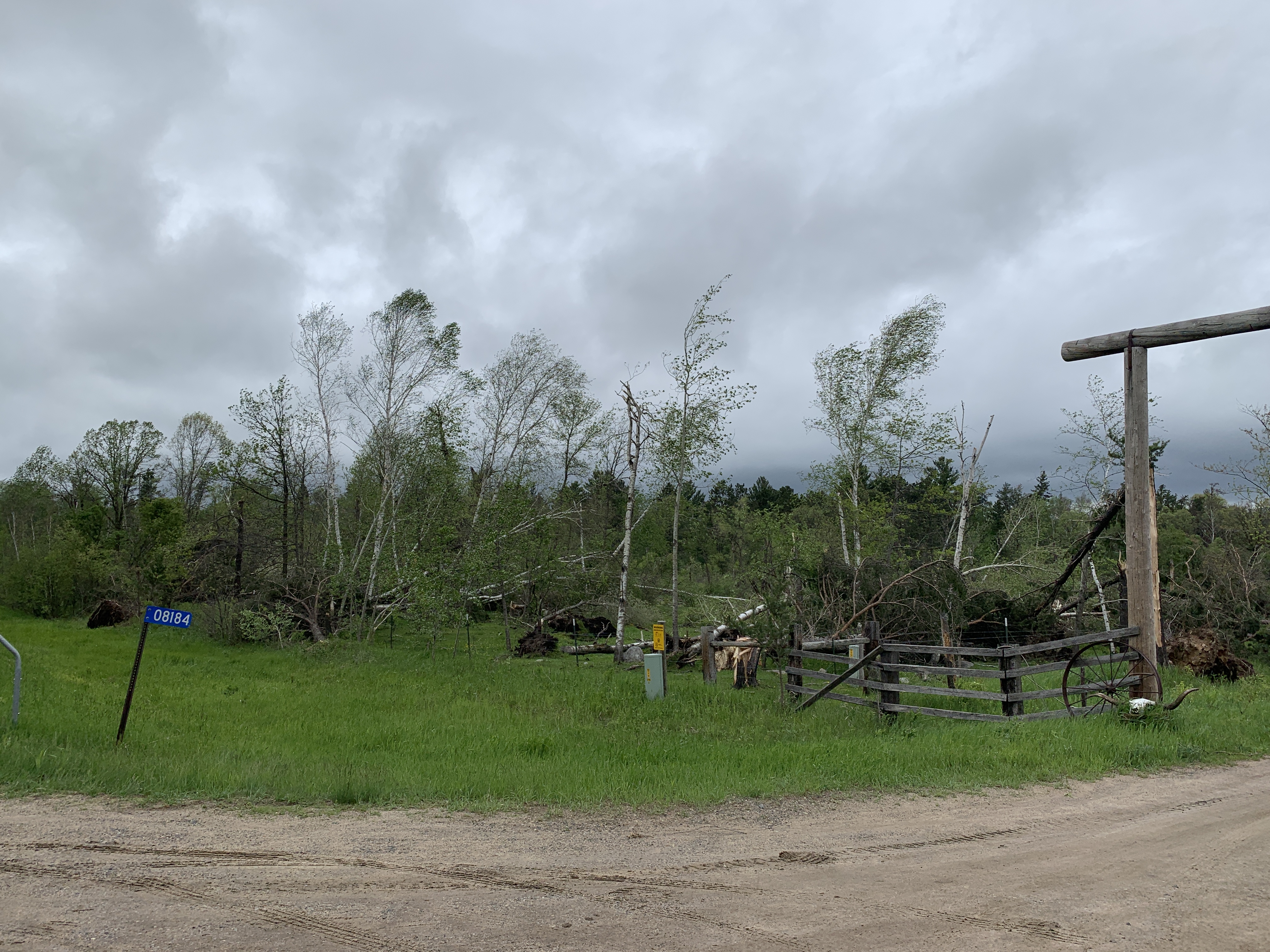
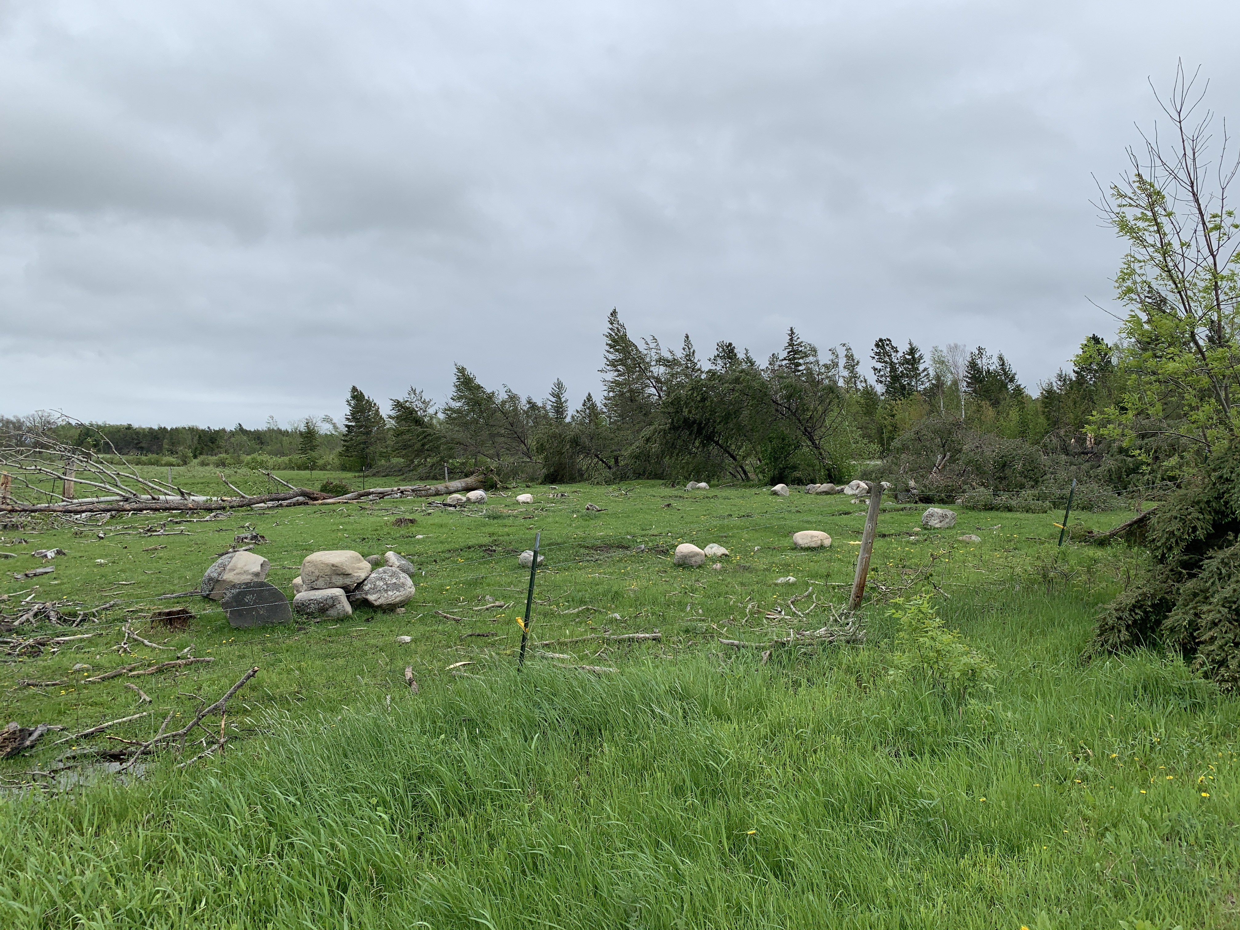
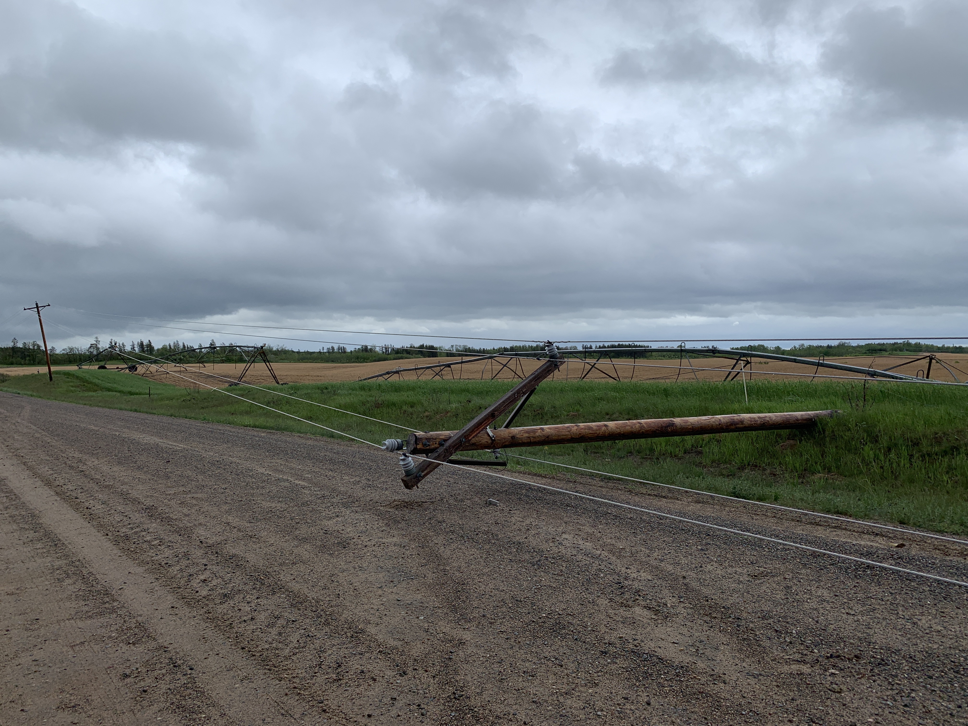
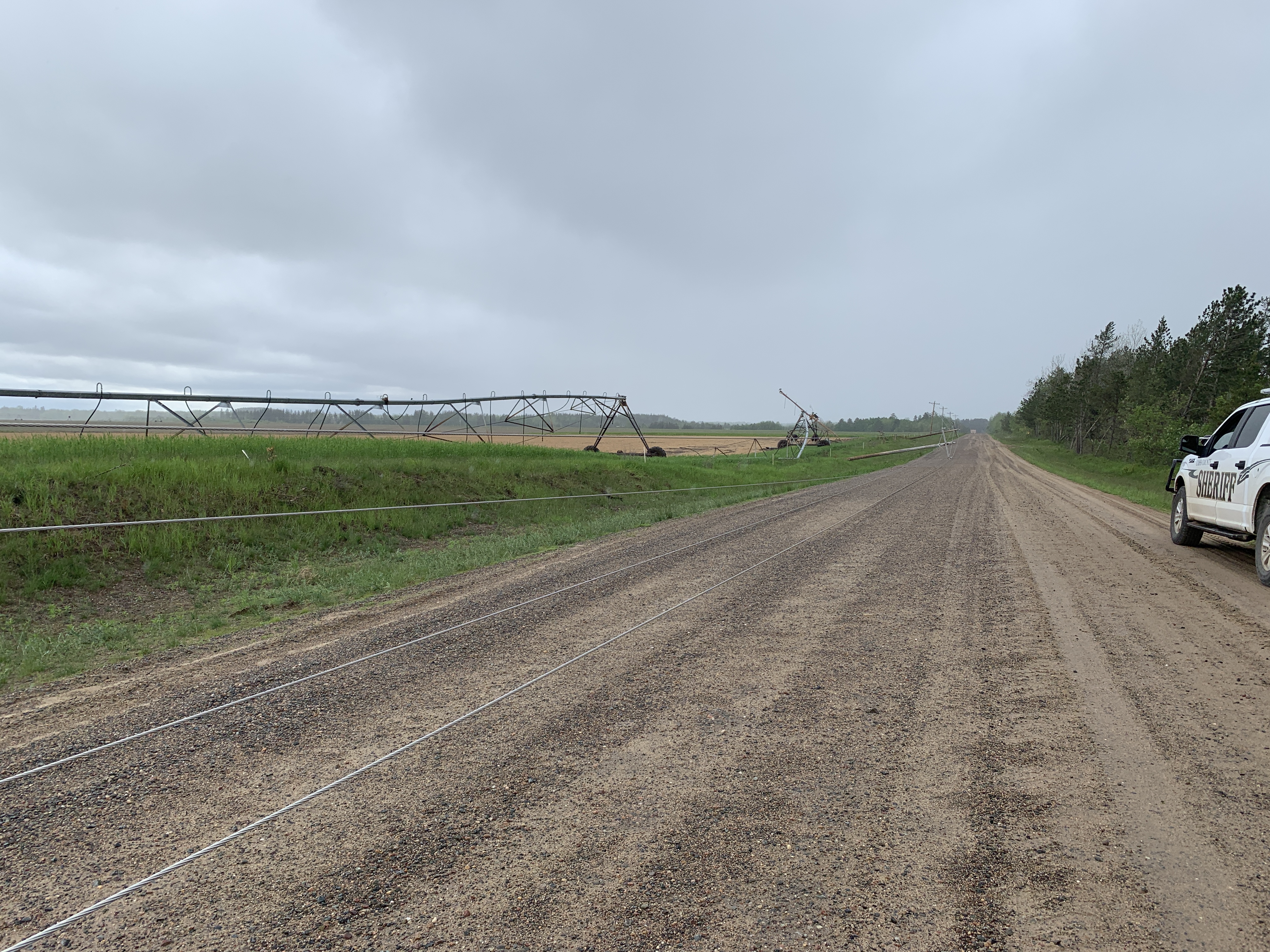
| Downed power lines and damaged center pivot irrigation system along CR 30 (NWS Duluth) |
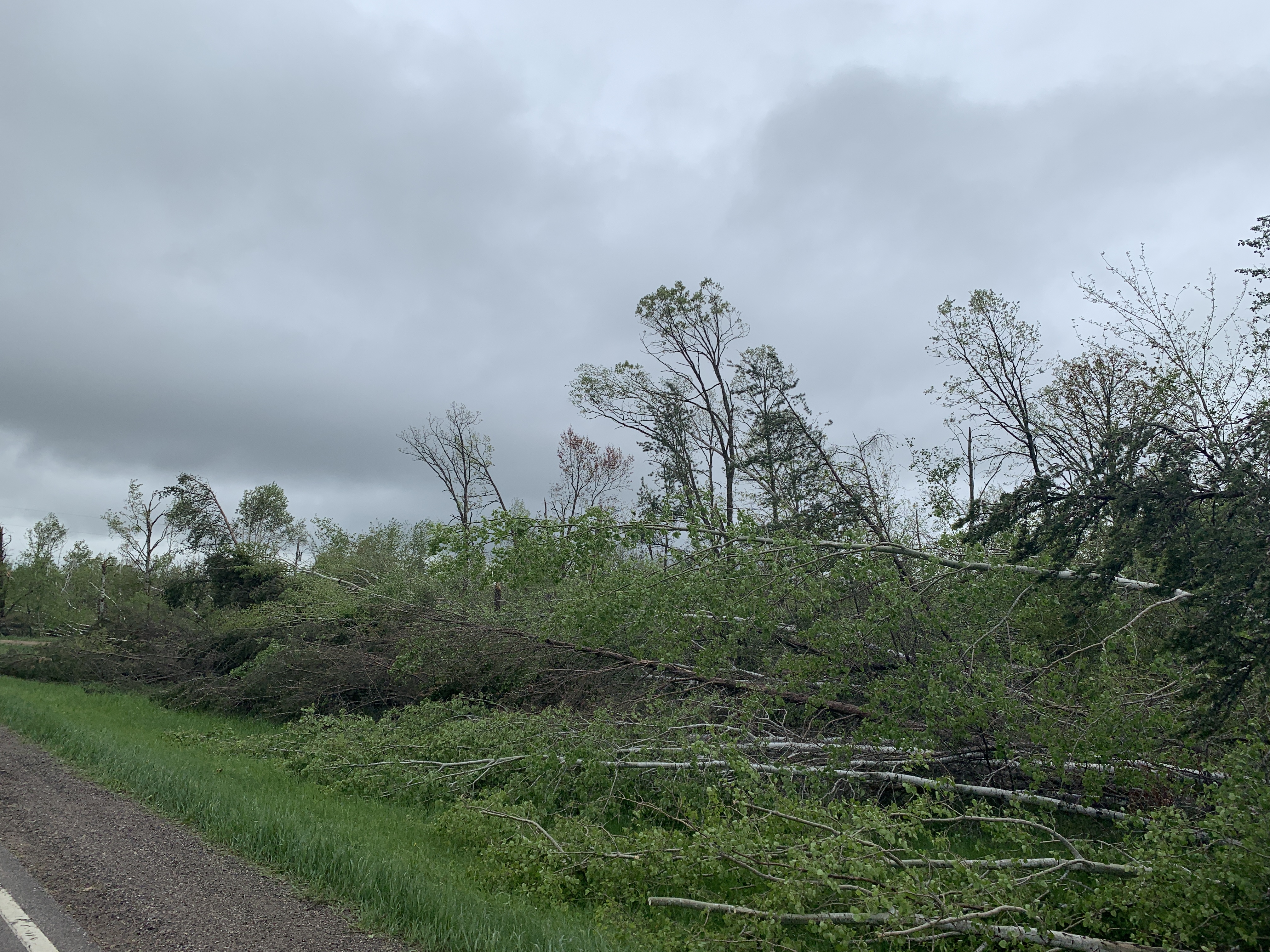
Tree damage along MN 64 (NWS Duluth) |
Tree damage along MN 64 (NWS Duluth) |
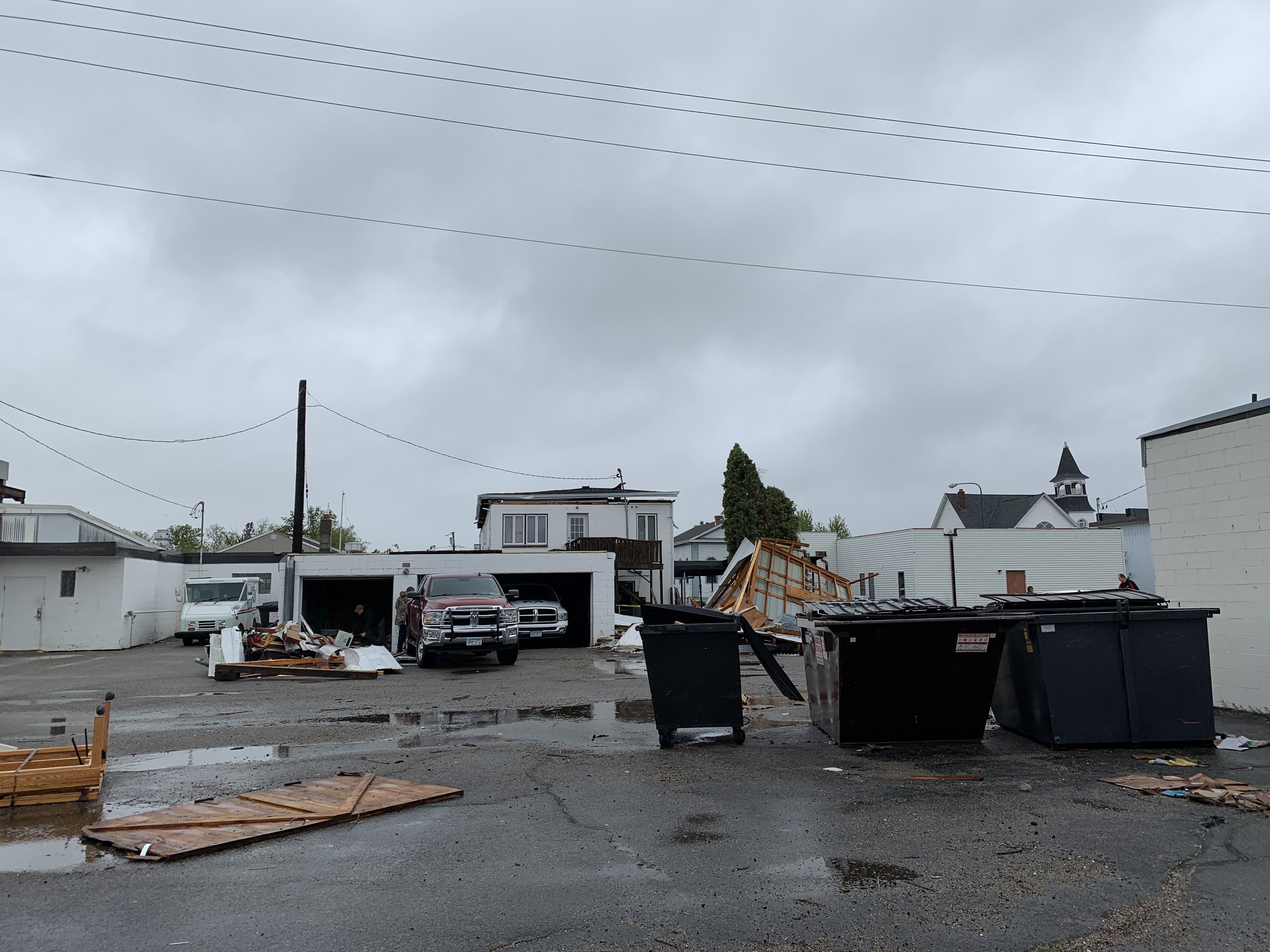
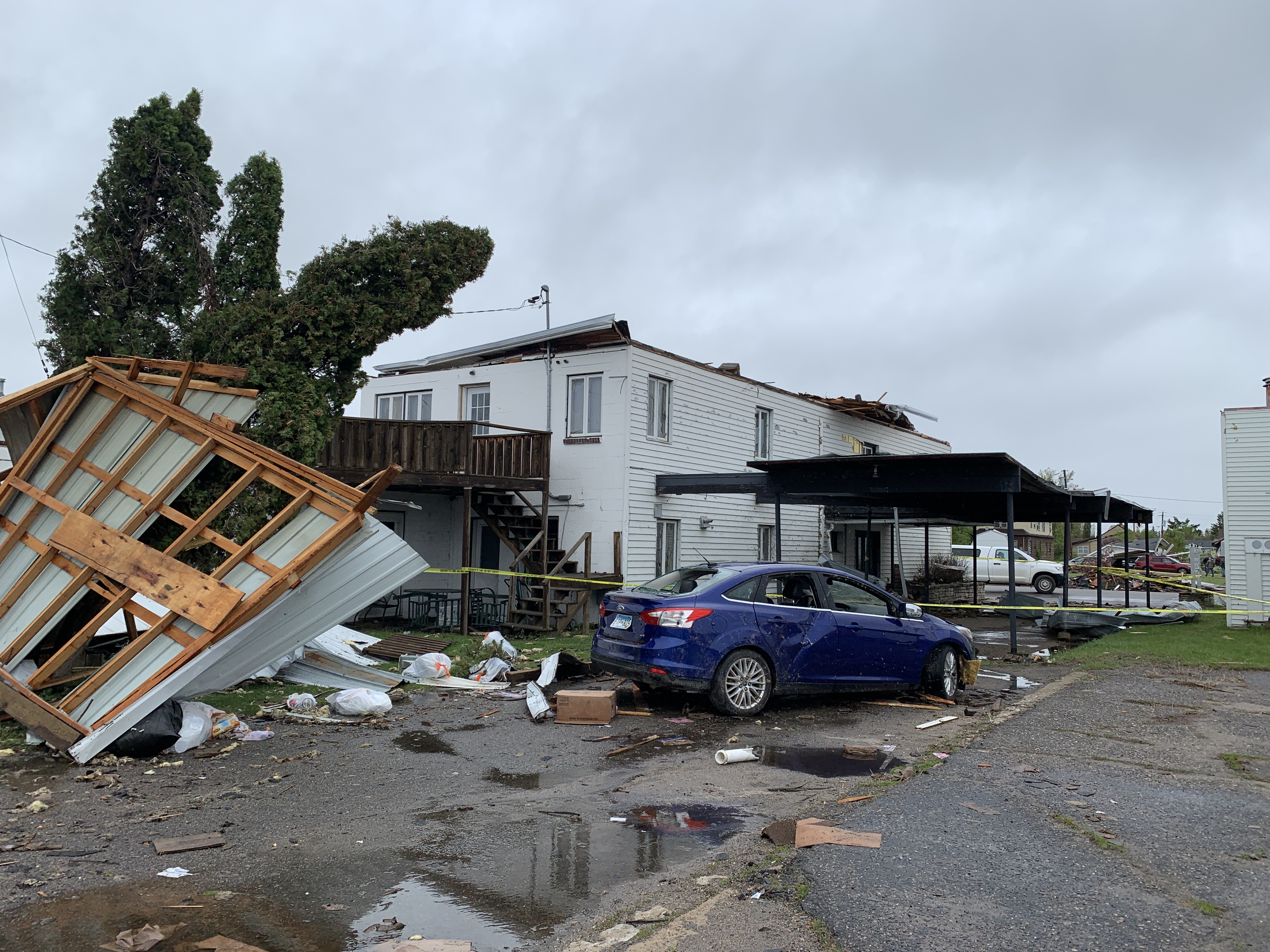
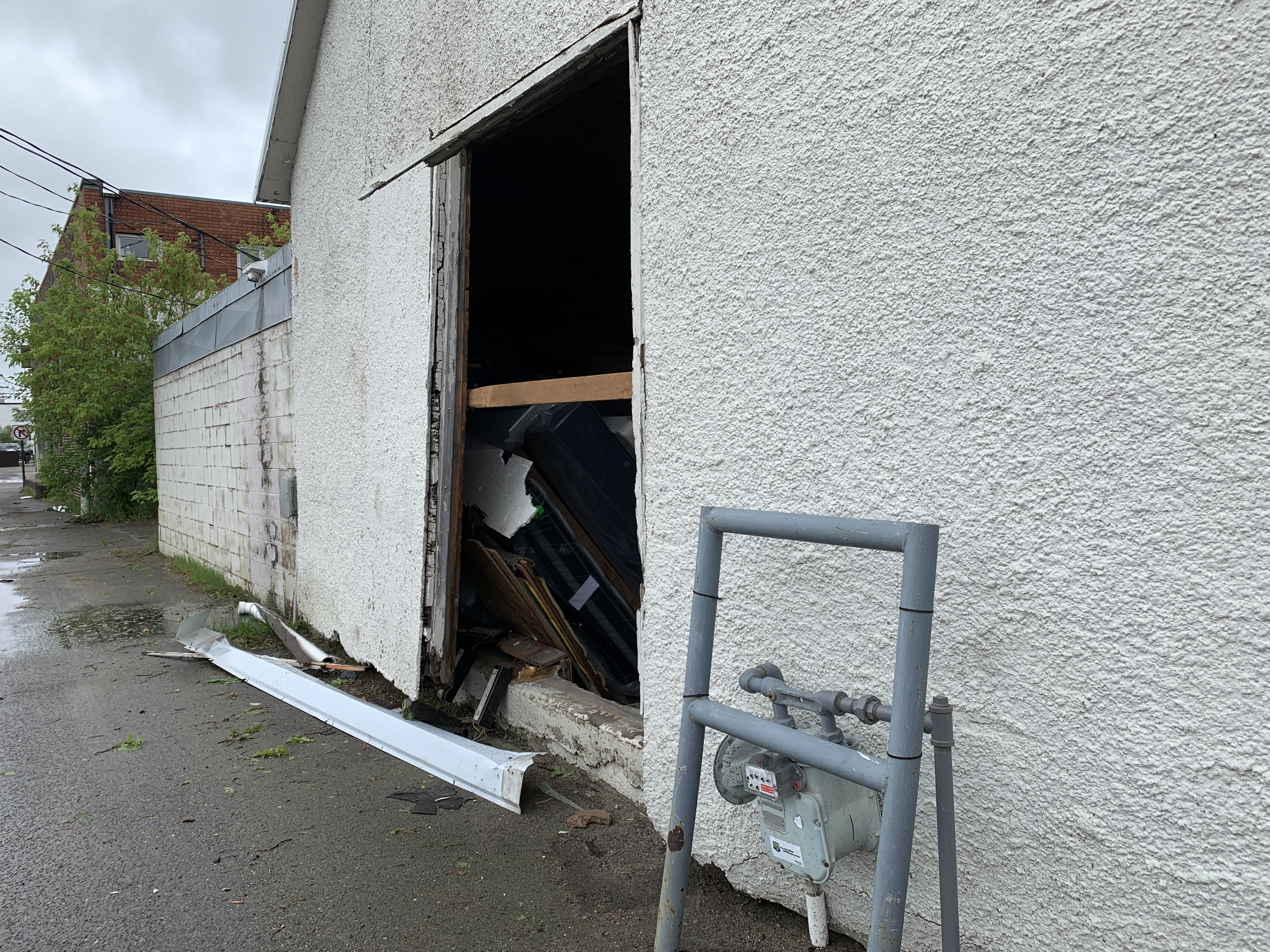
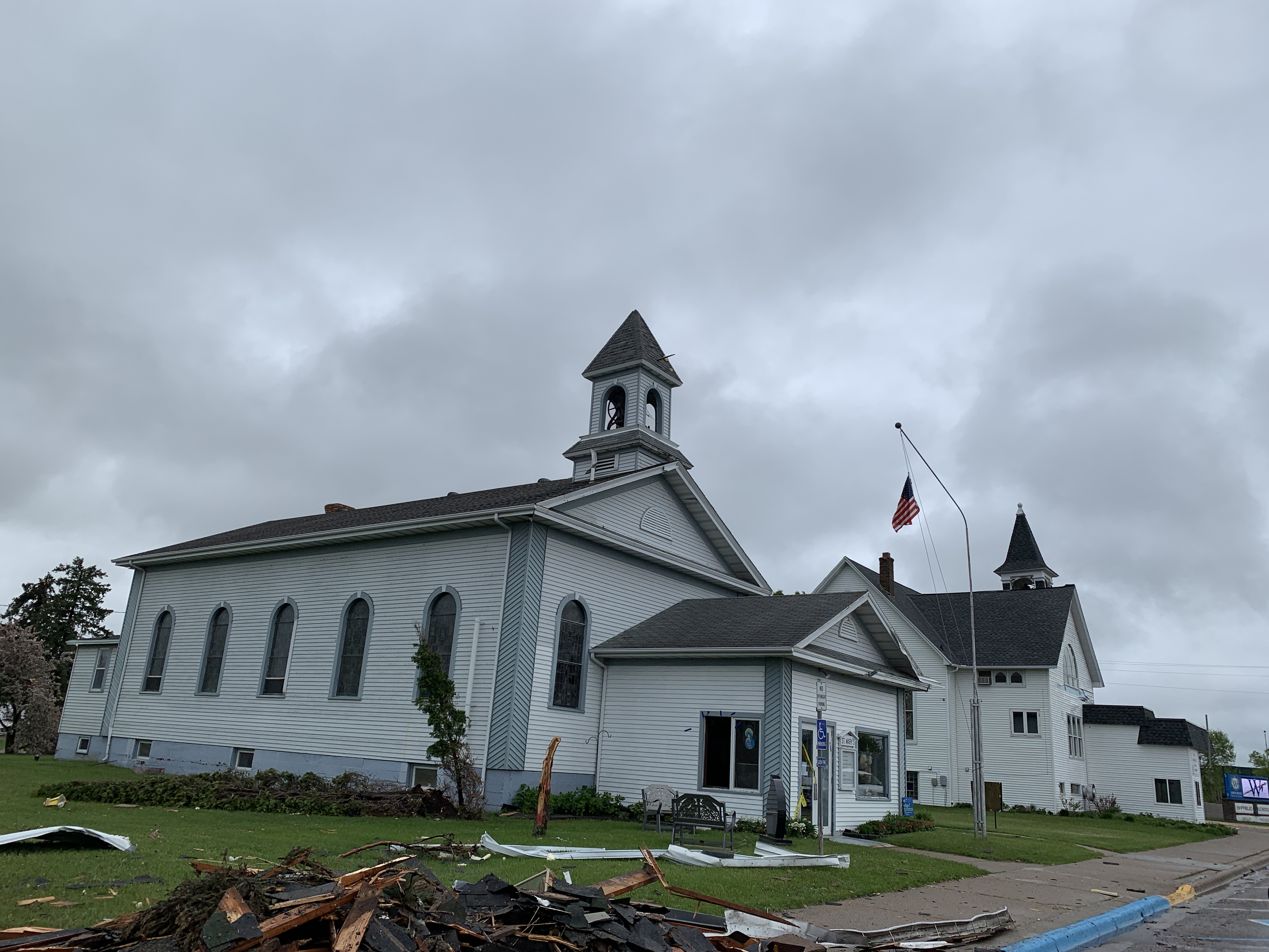
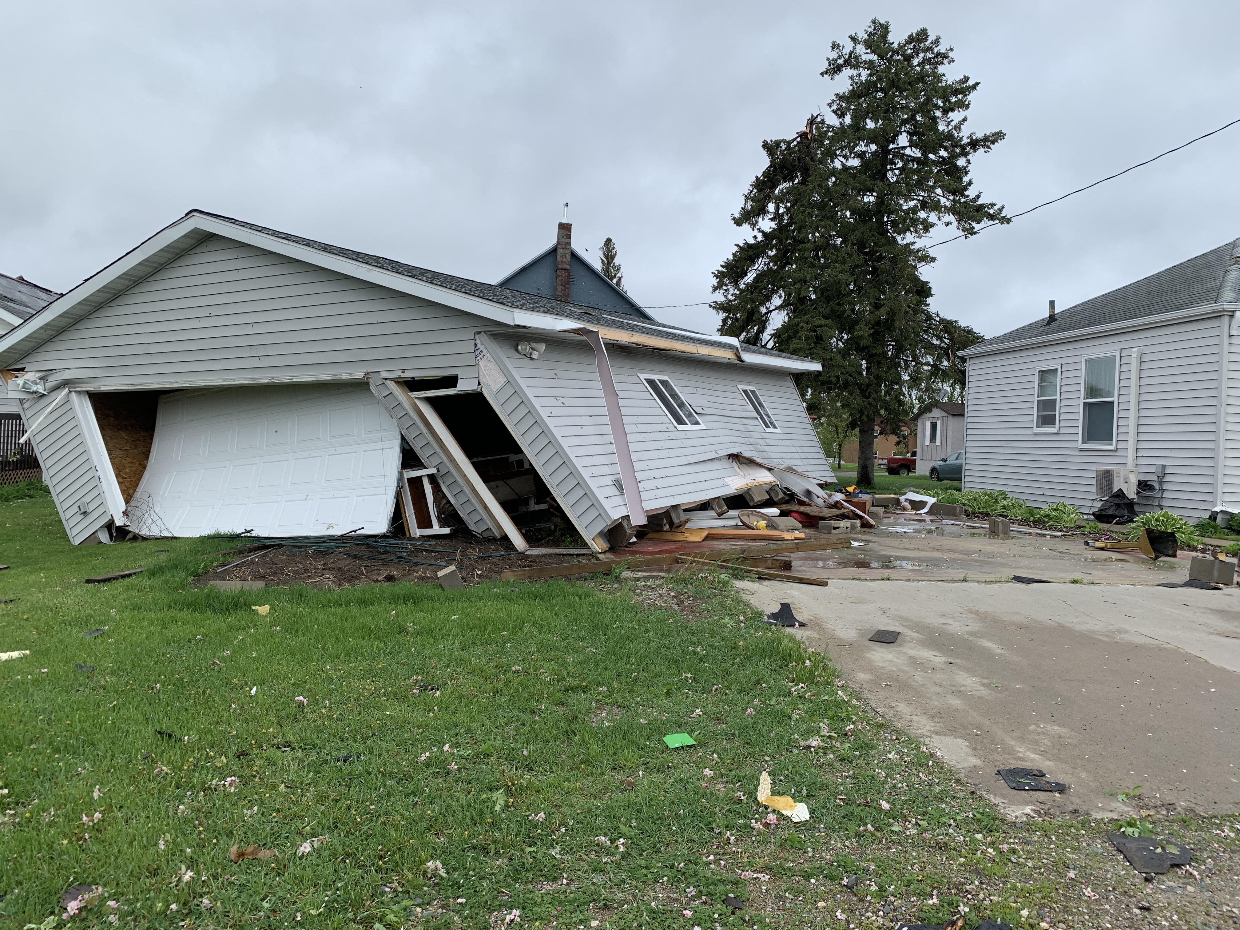
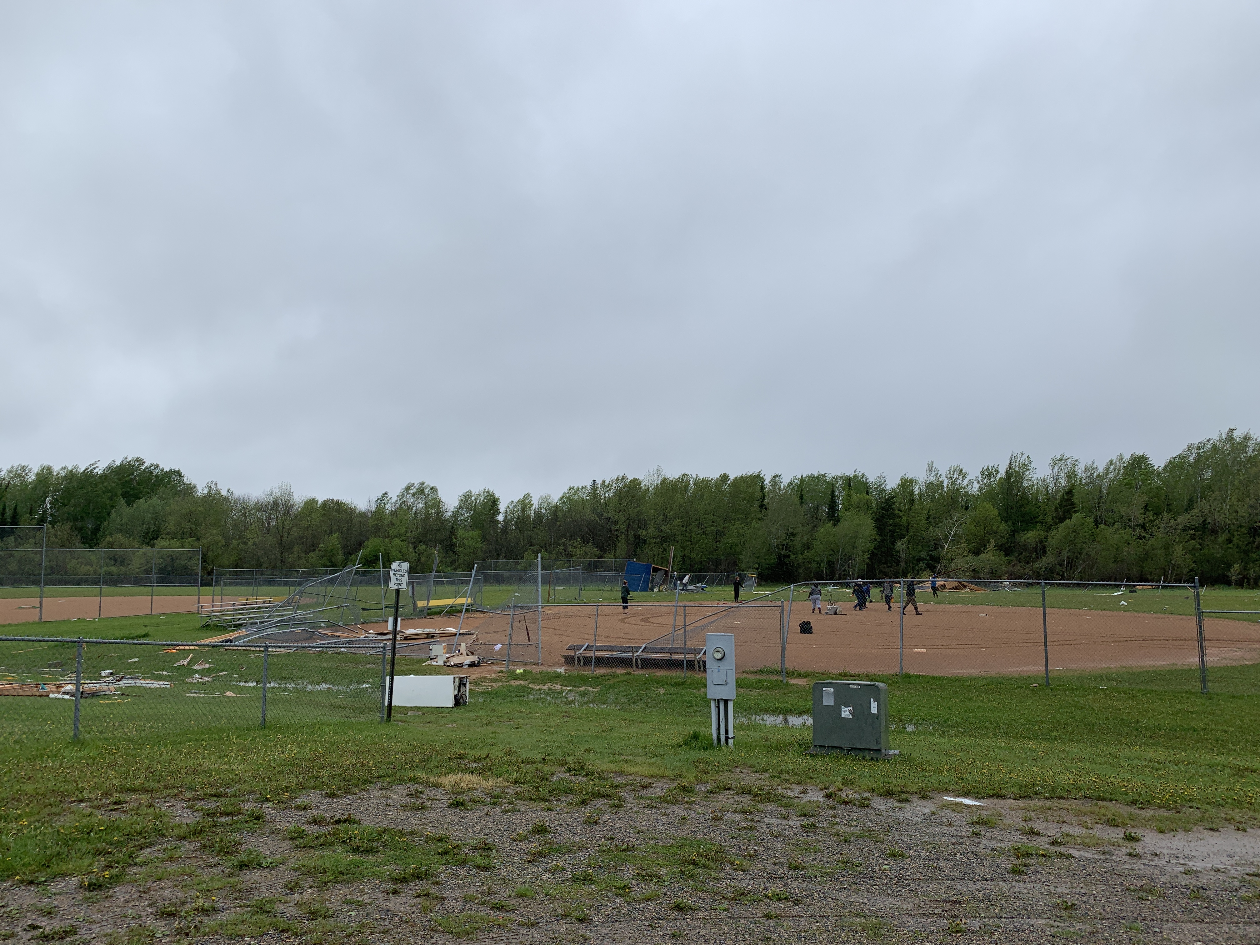
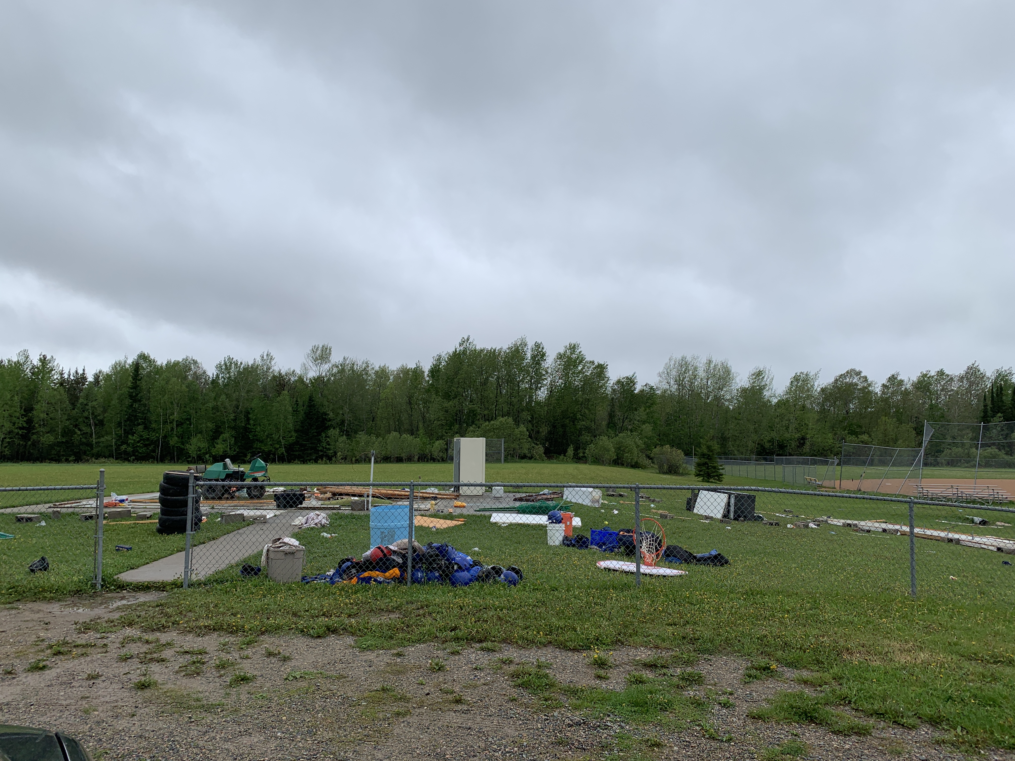
Deer River
 |
 |
 |
 |
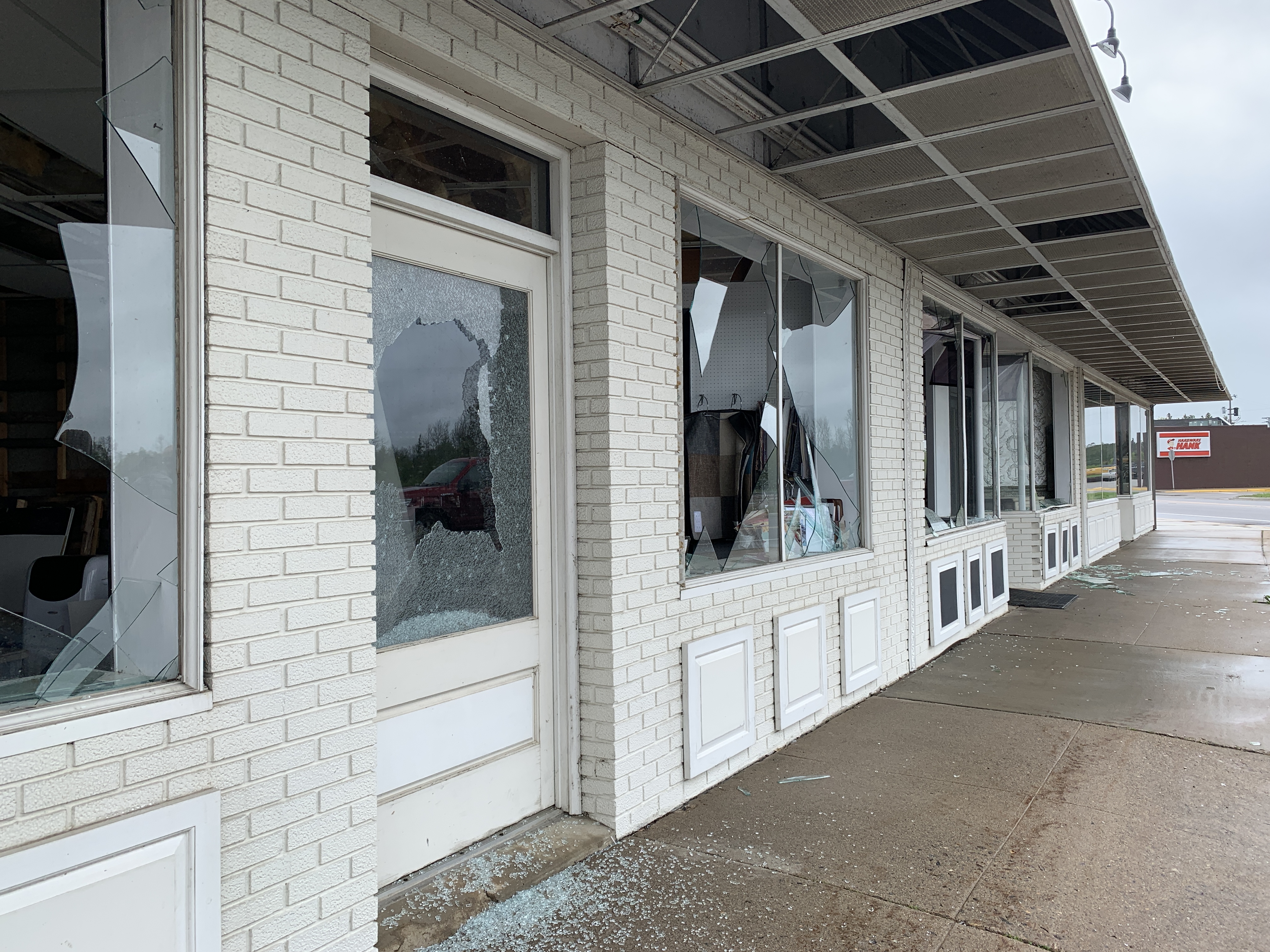
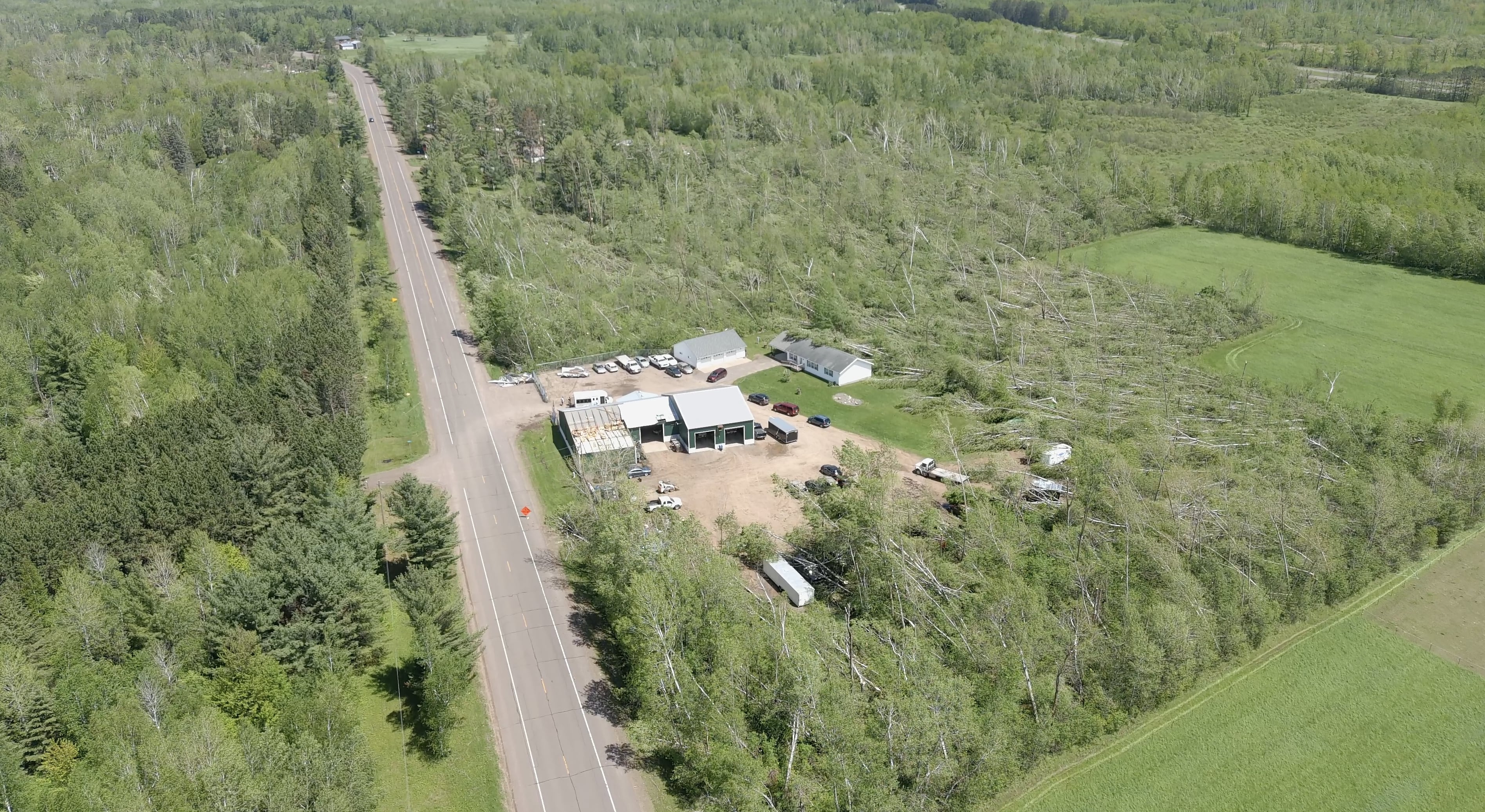
| Damage to a business along US 2 (NWS Duluth) |
Damage to a business along US 2 (NWS Duluth) |
Structure damage in the downtown area (NWS Duluth) |
Structure damage in the downtown area (NWS Duluth) |
 |
 |
 |
 |
| Structure damage in the downtown area (NWS Duluth) |
Structure damage in the downtown area. Note the board in the bell tower roof (NWS Duluth) |
Structure damage in the downtown area (NWS Duluth) |
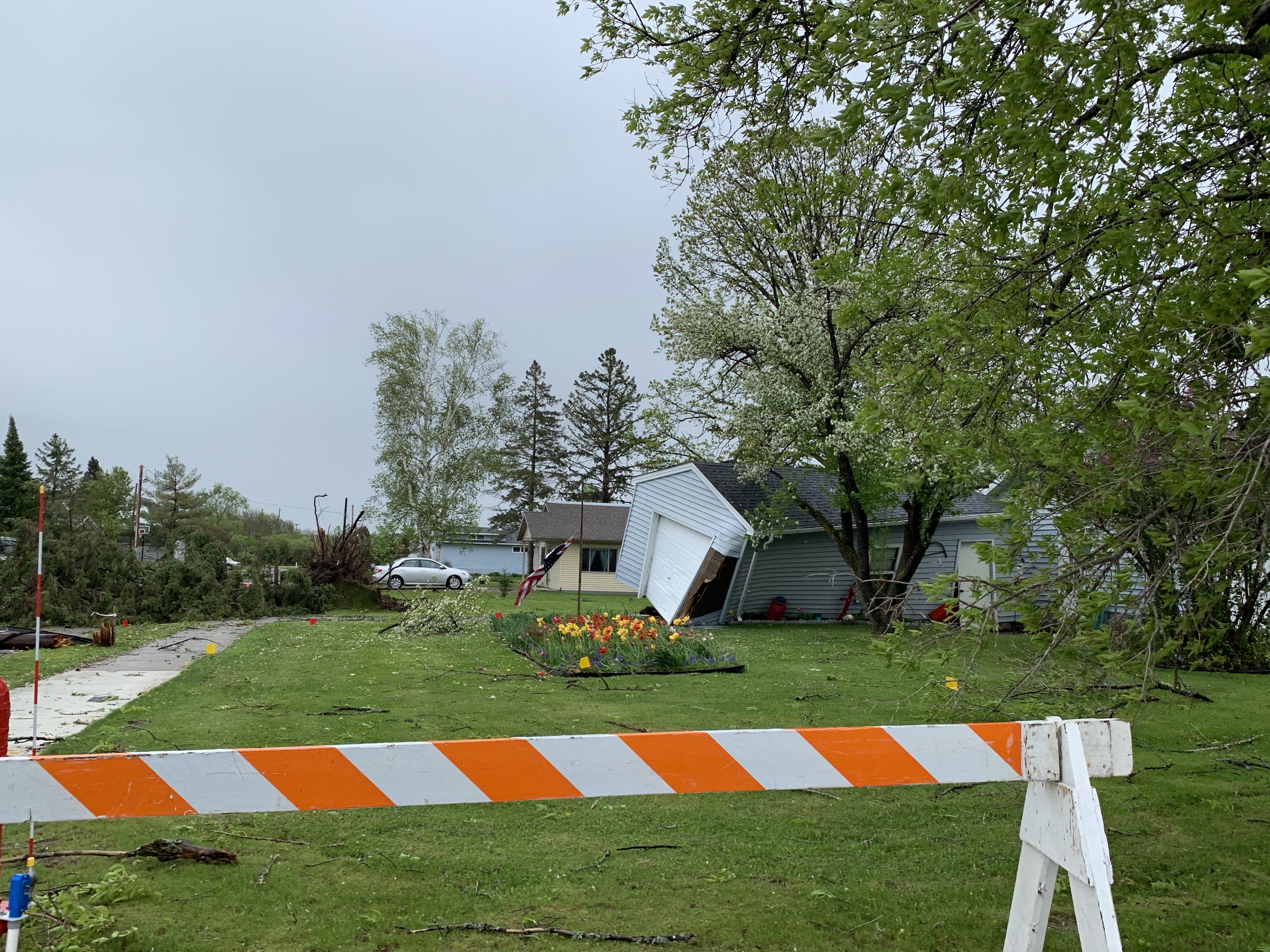
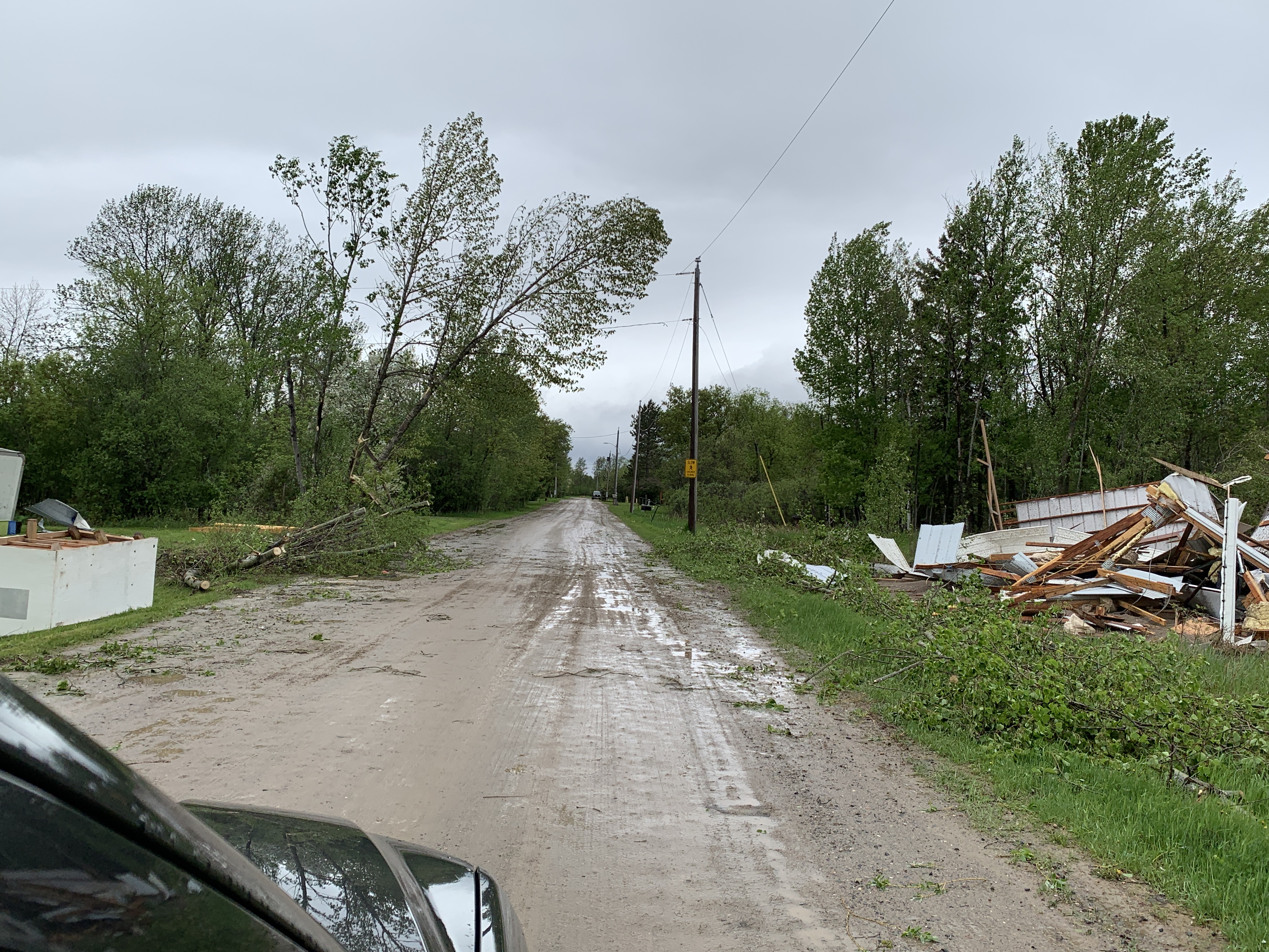
Structure damage to the north of the downtown area (NWS Duluth) |
 |
 |
 |
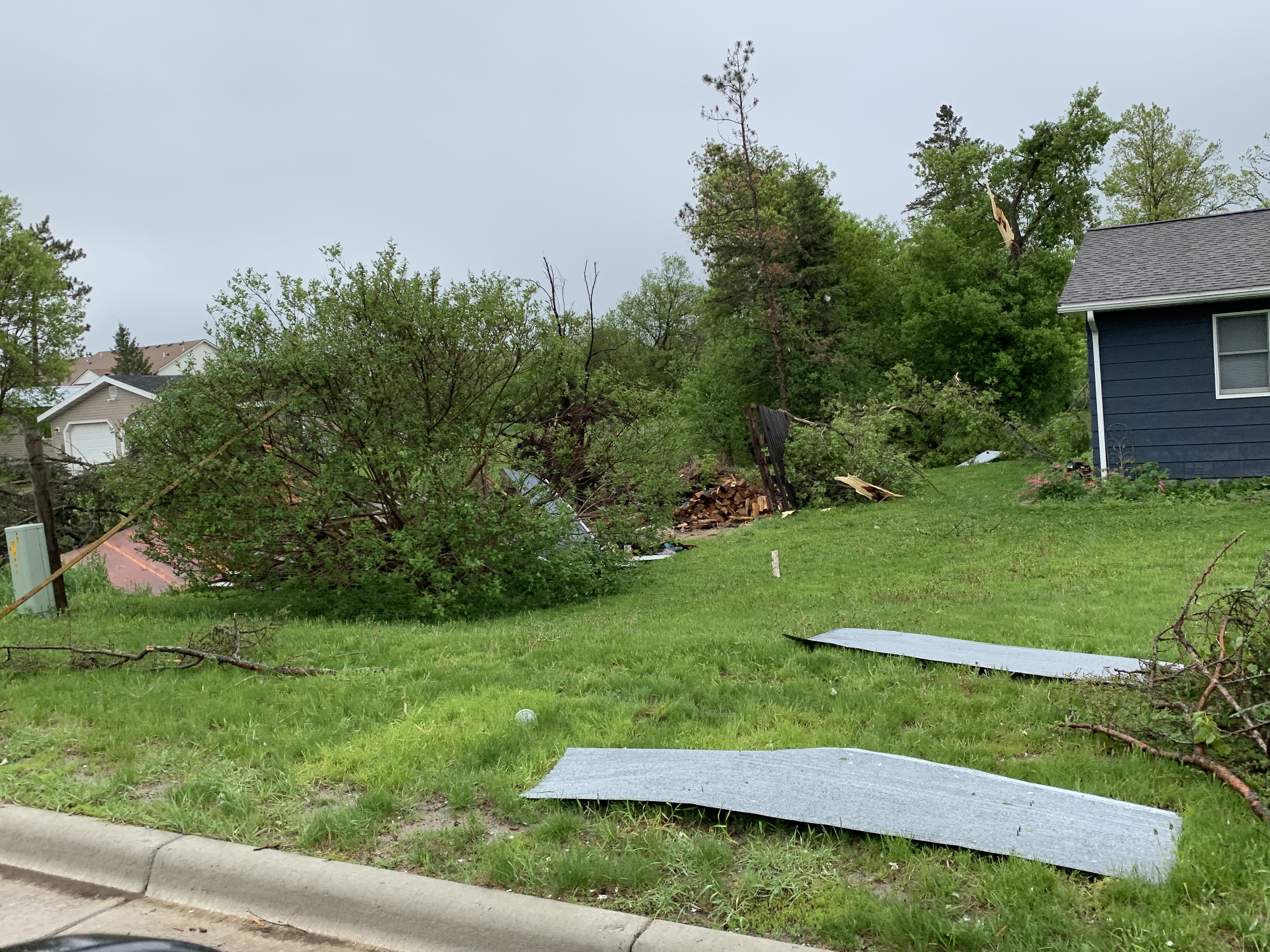 |
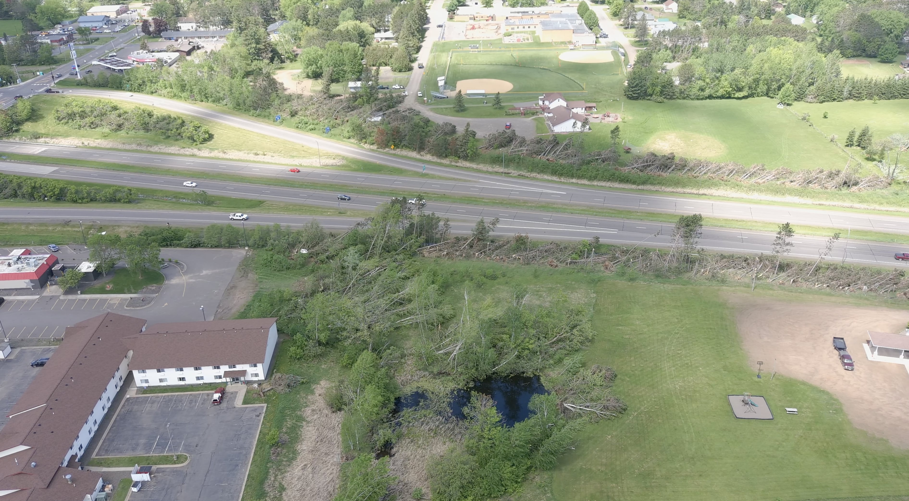
| Damage at the baseball fields on the north end of town (NWS Duluth) |
Damage at the baseball fields on the north end of town (NWS Duluth) |
Structure damage near Sixth Ave NE (NWS Duluth) |
Structure damage near Sixth Ave NE (NWS Duluth) |
 |
|||
| Damage along Eighth Ave NW (NWS Duluth) |
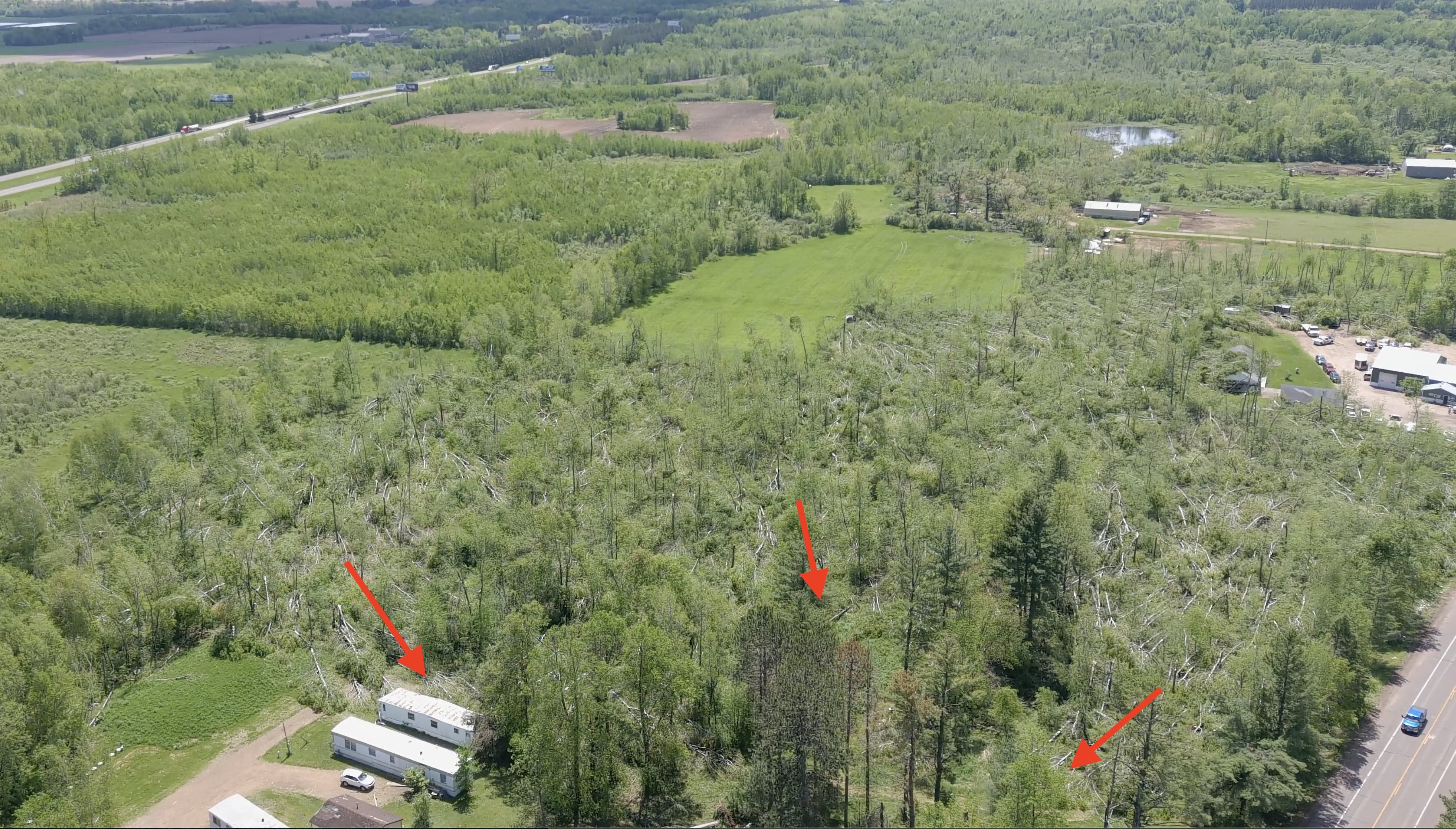
Hinckley
 |
 |
 |
 |
| Looking west across I-35 just north of the Hinckley exit. (Pine County EM) |
Looking west-northwest across I-35 just north of the Hinckley exit. (Pine County EM) |
Looking west-northwest across I-35 just north of the Hinckley exit. (Pine County EM) |
HVAC unit displaced on the roof of a restaurant at the Hinckley I-35 exit. (Pine County EM) |
 |
 |
 |
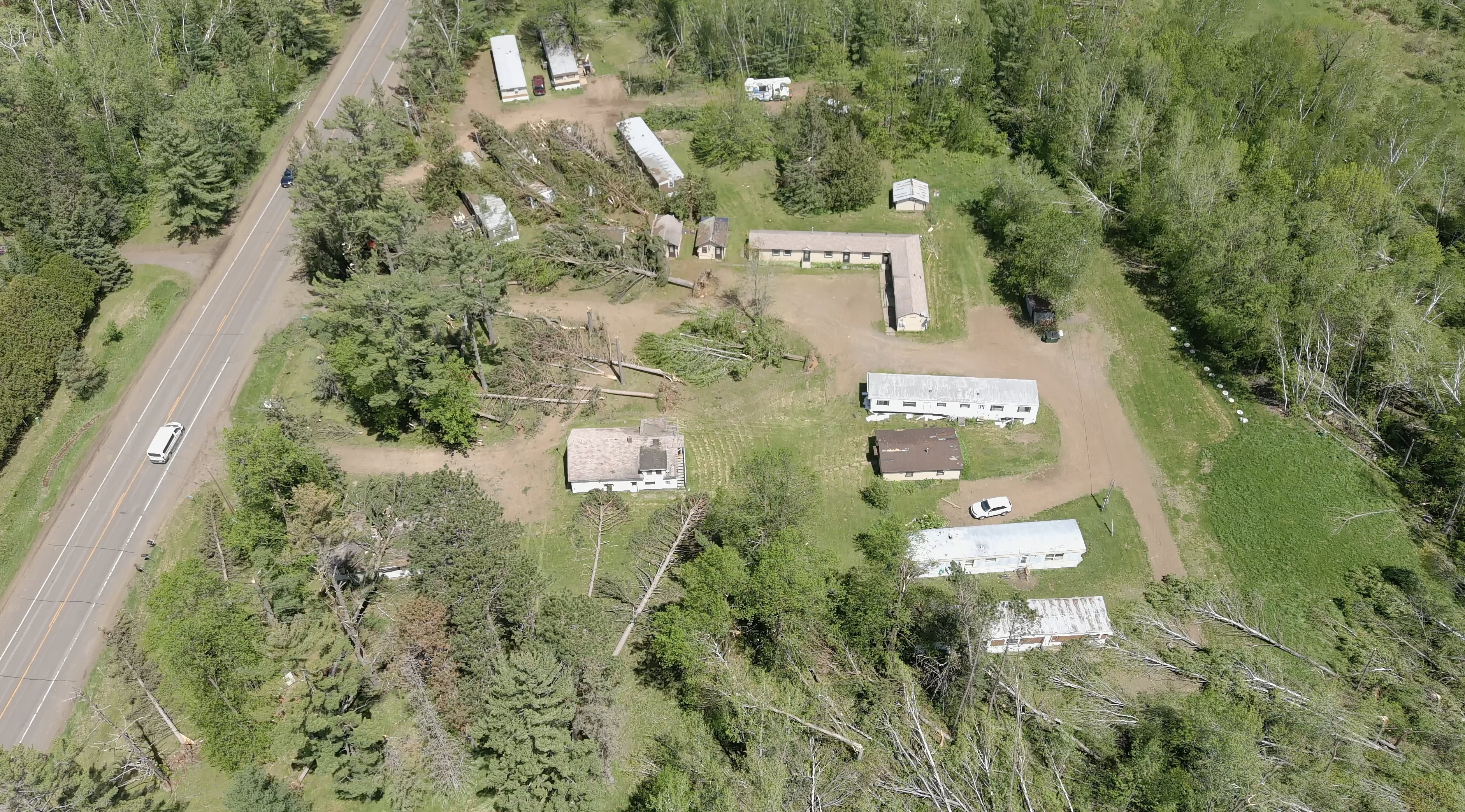 |
| Looking north-northeast across a damaged business along Highway 61 on the north side of Hinckley. (Pine County EM) |
Looking north-northeast across a damaged business along Highway 61 on the north side of Hinckley. (Pine County EM) |
Looking north across a stand of downed trees along Highway 61 on the north side of Hinckley. (Pine County EM) |
Looking north-northeast at a motel/trailer court along Highway 61 on the north side of Hinkley. (Pine County EM) |
 |
 |
||
| Looking north-northeast where the tornado crossed Highway 61 on the north side of Hinckley. (Pine County EM) |
Looking southeast from where the tornado crossed Highway 61 with arrows denoting the convergent tree fall pattern. (Pine County EM) |
Radar
Header
| Radar overview of the Poplar Township tornado. Additional tornadoes were found upstream from this one, but a continuous damage path across the county/CWA line was not found. | Radar overview of the Deer River and Cohasset tornadoes. Note that the radar was having dealiasing issues in the area of interest, making it difficult to see pertinant features. This area is ~80 miles from the radar and the lowest scan is ~5100'. The processes for QLCS tornadogenesis usually occur ~1600' or lower, so the radar is overshooting the area of interest in the storm. |
| Radar overview of the Hinckley tornado. Hinckley is ~65 miles from the radar with the lowest beam elevation ~3500', so the radar is again overshooting the area of interest. However, we can see a descending rear inflow jet approaching from the southwest. This feature is believed to have played a part in tornadogenesis in addition to bringing damaging straight-line winds to the central part of Hinckley. | Radar overview of a null tornado case near Swatara. There is a CC drop nearly colocated with some broad circulation which may be a TDS. However, these features were located in an area of low reflectivity ahead of the storm and are most likely cause by side lobe contamination. |
Storm Reports
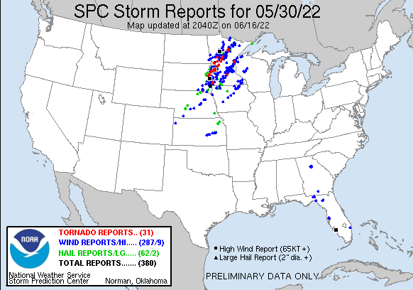
Click the image above for Storm Reports from around the country.
View a Local Storm Reports map here: https://mesonet.agron.iastate.edu/lsr/#DLH/202205300500/202205310500/011010.
PRELIMINARY LOCAL STORM REPORT...SUMMARY
NATIONAL WEATHER SERVICE DULUTH MN
355 PM CDT WED JUNE 1 2022
..TIME... ...EVENT... ...CITY LOCATION... ...LAT.LON...
..DATE... ....MAG.... ..COUNTY LOCATION..ST.. ...SOURCE....
..REMARKS..
0358 AM Hail 2 S Backus 46.79N 94.51W
05/30/2022 M0.70 inch Cass MN Public
Report sent in via social media.
0400 AM Hail 2 NE Sturgeon Lake 46.41N 92.80W
05/30/2022 M1.25 inch Pine MN Public
Report via social media with photos.
0407 AM Hail 2 W Silica 47.25N 93.06W
05/30/2022 U0.50 inch St. Louis MN Public
Report from mPING: Half-inch (0.50 in.).
0413 AM Hail 2 S Waukenabo 46.71N 93.60W
05/30/2022 M0.70 inch Aitkin MN Public
Report sent in via social media.
0415 AM Hail 1 NNE Moose Lake 46.46N 92.76W
05/30/2022 M2.00 inch Carlton MN Broadcast Media
Picture of hen egg sized hail with ruler.
0416 AM Hail Moose Lake 46.45N 92.77W
05/30/2022 M1.50 inch Carlton MN Public
Photo sent in via social media with a ruler
showing the size of the hailstone.
0419 AM Hail Moose Lake 46.45N 92.77W
05/30/2022 M1.25 inch Carlton MN Public
Photo sent in via social media of 1.25 inch
hail.
0423 AM Hail 1 NNE Moose Lake 46.46N 92.76W
05/30/2022 M1.00 inch Carlton MN Trained Spotter
0423 AM Hail 4 N Moose Lake 46.51N 92.78W
05/30/2022 U0.75 inch Carlton MN Public
Report from mPING: Dime (0.75 in.).
0424 AM Hail 2 SW Barnum 46.48N 92.70W
05/30/2022 U1.25 inch Carlton MN Public
Report from mPING: Half Dollar (1.25 in.).
0440 AM Hail 5 NE Mahtowa 46.62N 92.56W
05/30/2022 M1.00 inch Carlton MN Trained Spotter
0441 AM Hail 1 NW Chisholm 47.50N 92.89W
05/30/2022 U0.75 inch St. Louis MN Public
Report from mPING: Dime (0.75 in.).
0445 AM Hail 1 NW Chisholm 47.50N 92.89W
05/30/2022 U0.75 inch St. Louis MN Public
Report from mPING: Dime (0.75 in.).
0446 AM Hail Cloquet 46.72N 92.45W
05/30/2022 U0.75 inch Carlton MN Public
Report from mPING: Dime (0.75 in.).
0446 AM Hail Cloquet 46.72N 92.46W
05/30/2022 M1.00 inch Carlton MN Trained Spotter
0447 AM Hail Cloquet 46.71N 92.45W
05/30/2022 M1.00 inch Carlton MN Public
Report sent in via social media.
0447 AM Hail Cloquet 46.71N 92.47W
05/30/2022 U0.50 inch Carlton MN Public
Report from mPING: Half-inch (0.50 in.).
0448 AM Hail 1 NNE Cloquet 46.74N 92.45W
05/30/2022 U0.75 inch Carlton MN Public
Report from mPING: Dime (0.75 in.).
0450 AM Hail Scanlon 46.71N 92.43W
05/30/2022 U0.50 inch Carlton MN Public
Report from mPING: Half-inch (0.50 in.).
0459 AM Hail 4 NNE Munger 46.85N 92.32W
05/30/2022 M1.00 inch St. Louis MN Public
0500 AM Hail 4 ESE Twig 46.86N 92.29W
05/30/2022 M1.00 inch St. Louis MN Public
Report sent in via social media.
0505 AM Hail 2 NE Munger 46.83N 92.31W
05/30/2022 M1.25 inch St. Louis MN Public
Photo sent in on social media of a ruler
showing the size of the hailstone.
0505 AM Tstm Wnd Dmg 2 WSW Wealthwood 46.35N 93.70W
05/30/2022 Aitkin MN Public
Two pontoon boats over turned and a boat
lift mangled. Porch furniture blown off
porch. a tree was snapped off and a large
tree branch was down as well.
0508 AM Tstm Wnd Dmg 1 ESE Brainerd 46.35N 94.18W
05/30/2022 Crow Wing MN Public
Photos received of trees down along Oak Ave
in Brainerd.
0512 AM Hail 1 E Cloquet 46.72N 92.45W
05/30/2022 U0.50 inch Carlton MN Public
Report from mPING: Half-inch (0.50 in.).
0514 AM Tstm Wnd Gst 4 NE Brainerd 46.40N 94.13W
05/30/2022 M68 MPH Crow Wing MN Mesonet
Mesonet station BIRM5 Brainerd RAWS. Time
estimated by radar.
0515 AM Hail Embarrass 47.66N 92.20W
05/30/2022 M2.00 inch St. Louis MN Public
Report via social media with photos and
video. Observer reports damage done to cars
from hail.
0515 AM Tstm Wnd Dmg 8 SE Brainerd 46.27N 94.08W
05/30/2022 Crow Wing MN Public
Photo sent in via social media of an oak
tree that was blown over near South Long
Lake.
0515 AM Tstm Wnd Dmg 7 ESE Brainerd 46.30N 94.06W
05/30/2022 Crow Wing MN Public
Numerous trees down and snapped, some over
power lines which fell down. Report via
social media with pictures.
0526 AM Tstm Wnd Dmg 5 NE Brainerd 46.40N 94.12W
05/30/2022 Crow Wing MN Trained Spotter
Photo sent in via social media showing a
white pine tree snapped near the base of the
trunk.
0526 AM Tstm Wnd Dmg 2 SSE Deerwood 46.44N 93.87W
05/30/2022 Crow Wing MN Public
Multiple trees down blocking County Highway
133 in both directions. Time estimated by
radar.
0659 AM Hail 1 SSW Grand Marais 47.75N 90.35W
05/30/2022 M1.00 inch Cook MN NWS Employee
Corrects previous hail report from 1 SSW
Grand Marais. A lot of nickel size hail fell
with several quarter size stones.
0700 AM Hail Grand Marais 47.76N 90.35W
05/30/2022 U0.50 inch Cook MN Public
Report from mPING: Half-inch (0.50 in.).
0730 AM Flood Keewatin 47.40N 93.08W
05/30/2022 Itasca MN Trained Spotter
Drove around Keewatin and found minor
flooding in ditches and low lying areas. A
lot of people talking about water in their
basements and sump pumps running
continuously.
0730 AM Hail 2 ENE Hovland 47.85N 89.93W
05/30/2022 E1.00 inch Cook MN Trained Spotter
0524 PM Hail 4 WNW Hackensack 46.95N 94.59W
05/30/2022 E1.00 inch Cass MN Trained Spotter
Pea to quarter size hail covering about ten
percent of the ground.
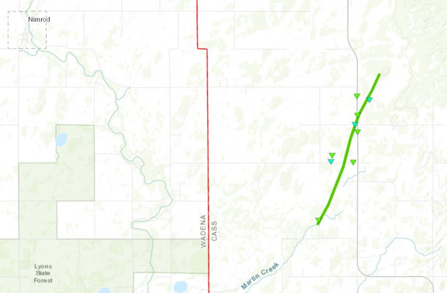
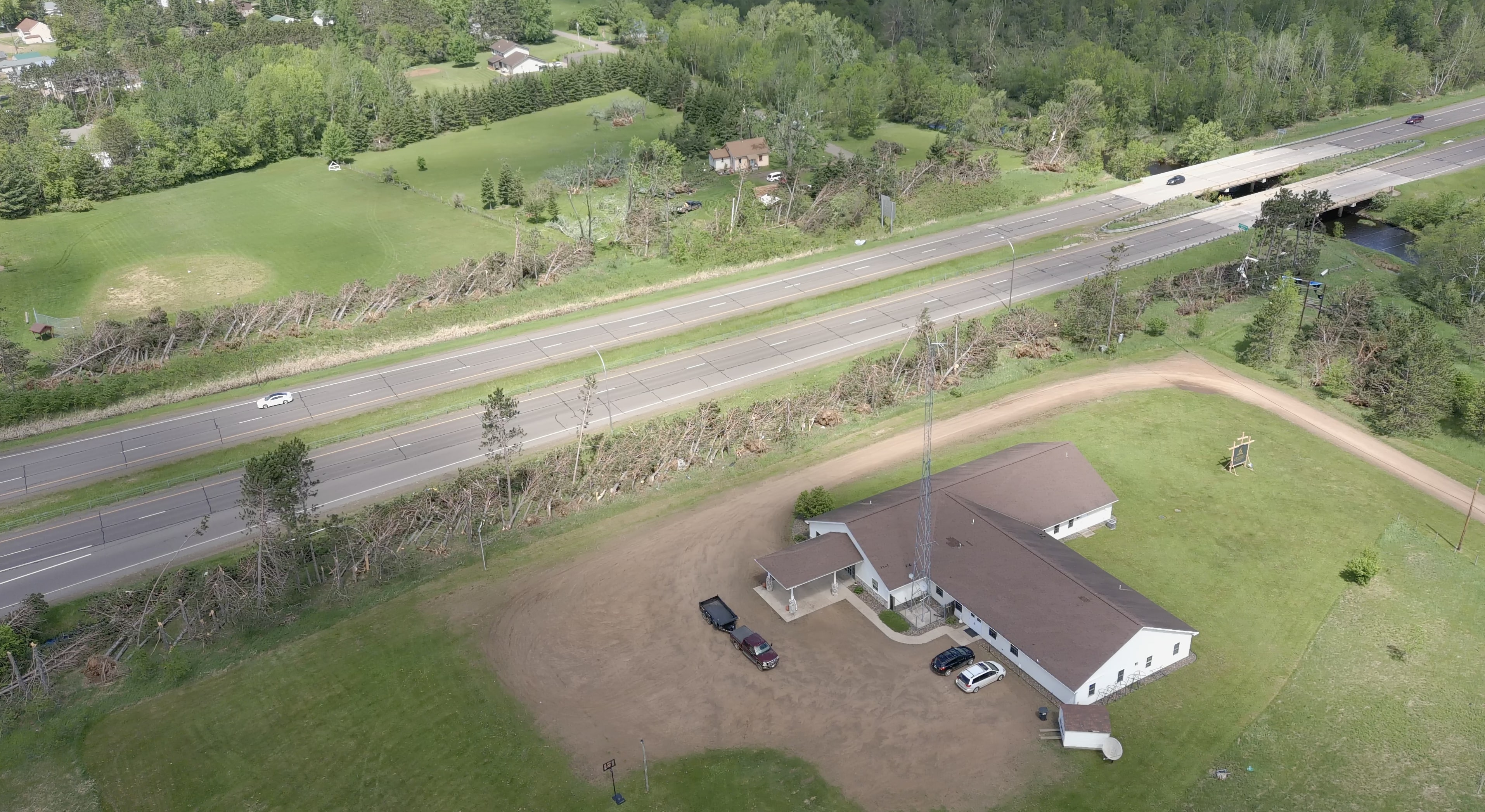
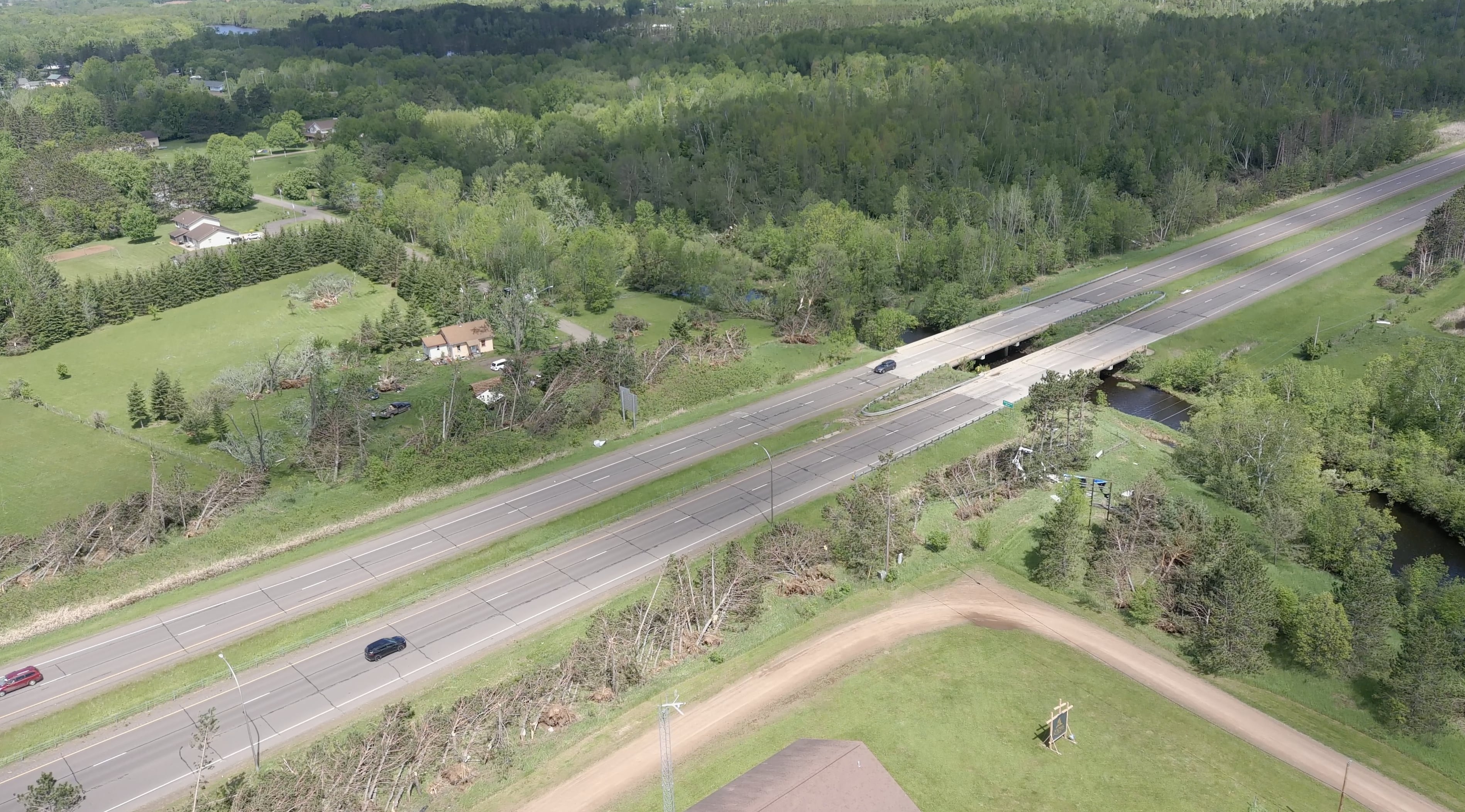
0537 PM Tornado 2 SSW Poplar 46.56N 94.72W
05/30/2022 Cass MN NWS Storm Survey
Beginning of EF-1 Tornado with max winds of
105 mph.
0540 PM Tstm Wnd Dmg 3 WNW Pillager 46.34N 94.53W
05/30/2022 Cass MN Trained Spotter
A few trees downed across MN 210. Time
estimated from radar.
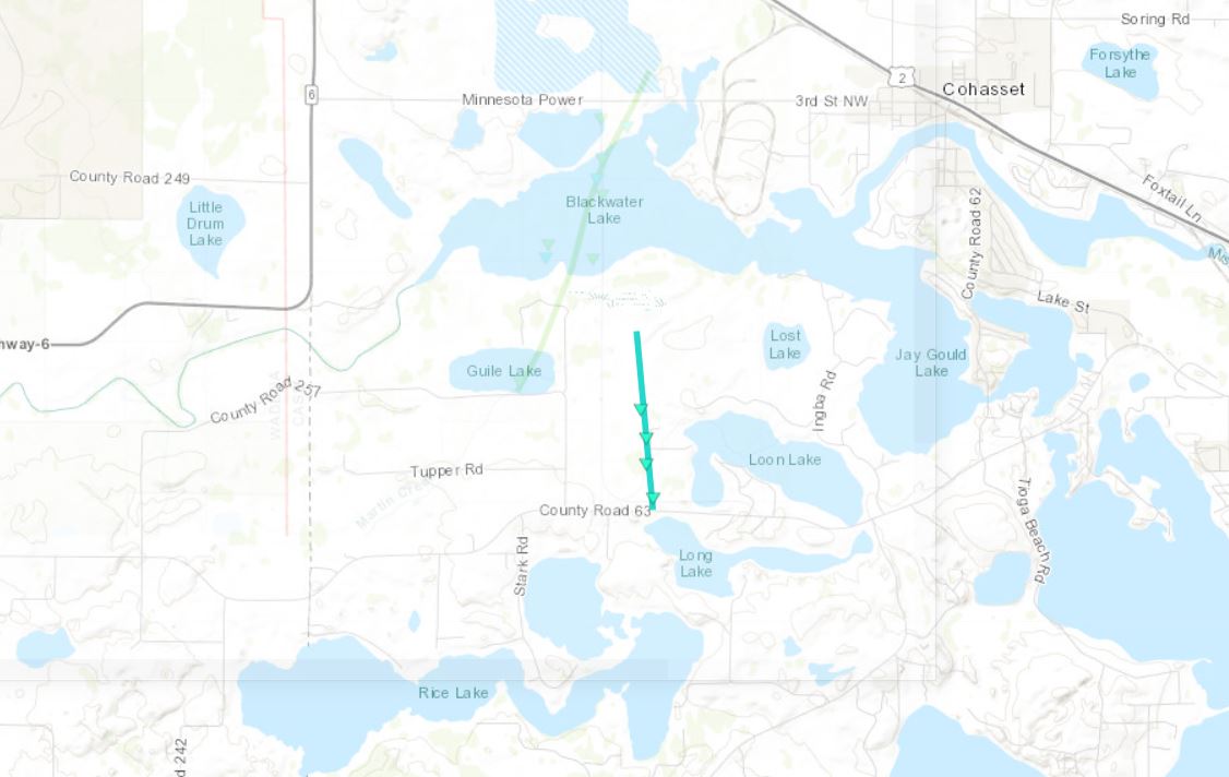
0544 PM Tornado 3 SW Cohasset 47.23N 93.66W
05/30/2022 Itasca MN NWS Storm Survey
Beginning of EF 0 tornado. Maximum winds of
85 mph. Max path width 40 yards.
0545 PM Tornado 2 NNE Poplar 46.62N 94.68W
05/30/2022 Cass MN NWS Storm Survey
Approximate end of EF 1 tornado. Path length
4.3 miles. Path width estimated 500 yards.
Max winds estimated 105 mph.
0546 PM Tornado 2 SW Cohasset 47.24N 93.66W
05/30/2022 Itasca MN NWS Storm Survey
End of EF 0 Tornado with maximum winds of 85
mph and a path width of 40 yards.
0555 PM Tstm Wnd Gst 4 NW Walker 47.13N 94.65W
05/30/2022 M45 MPH Cass MN AWOS
AWOS station KY49 Walker MN AWOS.
0556 PM Tstm Wnd Dmg 1 NE Lake Shore 46.51N 94.34W
05/30/2022 Cass MN Public
Many trees down over power lines and some on
buildings. Photo shows one tree with an
estimated diameter of 12 to 14 inches.
Report from social media. Time estimated by
radar.
0558 PM Tstm Wnd Dmg 3 SSE Pequot Lakes 46.56N 94.31W
05/30/2022 Crow Wing MN Public
Corrects date of previous tstm wnd dmg
report from 3 SSE Pequot Lakes. Photo via
social media. Several trees down. Tree
debris scattered over road. Power out. Time
estimated from radar.
0558 PM Tstm Wnd Dmg 2 SW Backus 46.80N 94.55W
05/30/2022 Cass MN Public
Extensive damage to several farms and homes.
Time estimated from radar.
0600 PM Tstm Wnd Dmg 1 E Pequot Lakes 46.60N 94.30W
05/30/2022 Crow Wing MN Storm Chaser
Cluster of trees down on a powerline on
County Hwy 11.
0600 PM Tstm Wnd Dmg Pine River 46.73N 94.40W
05/30/2022 Cass MN Public
Trees report down in the Pine River area.
Power is also out. Report from social media.
0602 PM Tstm Wnd Dmg 1 WNW Breezy Point 46.61N 94.24W
05/30/2022 Crow Wing MN Trained Spotter
Trees down and power out.
0602 PM Tstm Wnd Dmg 4 SSE Nisswa 46.46N 94.26W
05/30/2022 Crow Wing MN Public
Tree down on vehicle. Report relayed by
social media via a law enforcement scanner.
0602 PM Tstm Wnd Dmg Breezy Point 46.60N 94.22W
05/30/2022 Crow Wing MN Trained Spotter
A few trees knocked down with numerous
branches downed. Pea size hail also
observed.
0606 PM Tstm Wnd Dmg 3 WNW Remer 47.08N 93.96W
05/30/2022 Cass MN Public
Report via social media with pictures. Large
trees snapped at the base, several over
power lines.
0608 PM Tstm Wnd Dmg 4 SSW Swanburg 46.68N 94.20W
05/30/2022 Crow Wing MN Public
Boat lift and dock flipped on Lower
Whitefish Lake. Time estimated by radar.
0612 PM Tstm Wnd Dmg 4 S Cass Lake 47.33N 94.59W
05/30/2022 Cass MN Park/Forest Srvc
Photos via Chippewa National Forest of
numerous small to medium trees down over
forest roads. Time estimated from radar.
0612 PM Tstm Wnd Dmg Crosslake 46.68N 94.09W
05/30/2022 Crow Wing MN Public
12-14 inch tree snapped based on a picture
from social media. Time estimated.
0615 PM Tstm Wnd Dmg 4 N Hackensack 46.98N 94.53W
05/30/2022 Cass MN Public
Several large pine trees uprooted and
felled.
0615 PM Tstm Wnd Dmg Swanburg 46.74N 94.18W
05/30/2022 Crow Wing MN Public
Estimated 12 to 14 inch diameter pine tree
down on a deck. Report from social media.
0617 PM Tstm Wnd Dmg 1 ENE Inguadona 46.99N 94.11W
05/30/2022 Cass MN Trained Spotter
A few large trees down in a few spots. Time
estimated from radar.
0620 PM Hail 1 SE Inguadona 46.98N 94.12W
05/30/2022 E0.88 inch Cass MN Public
0620 PM Tstm Wnd Dmg 5 SSW Tobique 47.05N 94.08W
05/30/2022 Cass MN Trained Spotter
A large oak tree limb approximately halfway
up the tree was broken off. Numerous small
branches were also blown down along with
several nearby small trees.
0620 PM Tstm Wnd Dmg 2 NNW Wabedo 46.95N 94.20W
05/30/2022 Cass MN Public
Winds flipped over a dock on Little Boy
Lake.
0624 PM Tstm Wnd Dmg 4 ENE Brevik 47.11N 94.21W
05/30/2022 Cass MN Public
Estimated 10-12 inch diameter pine tree
based on an image from social media.
0633 PM Tstm Wnd Dmg Remer 47.06N 93.91W
05/30/2022 Cass MN Public
Chicken run, two trees, a cow shed and a
grill lost or damaged. Lots of debris blow
around. Report from social media. Time
estimated by radar.
0640 PM Hail 5 W Pine Center 46.21N 94.01W
05/30/2022 E0.70 inch Crow Wing MN Public
0645 PM Tstm Wnd Dmg 2 SE Emily 46.74N 93.94W
05/30/2022 Crow Wing MN Public
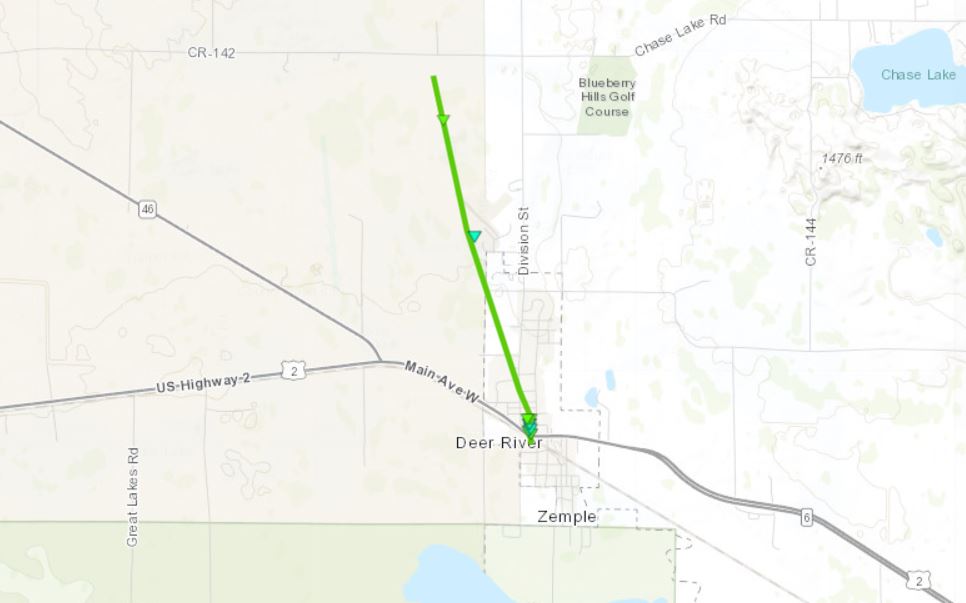
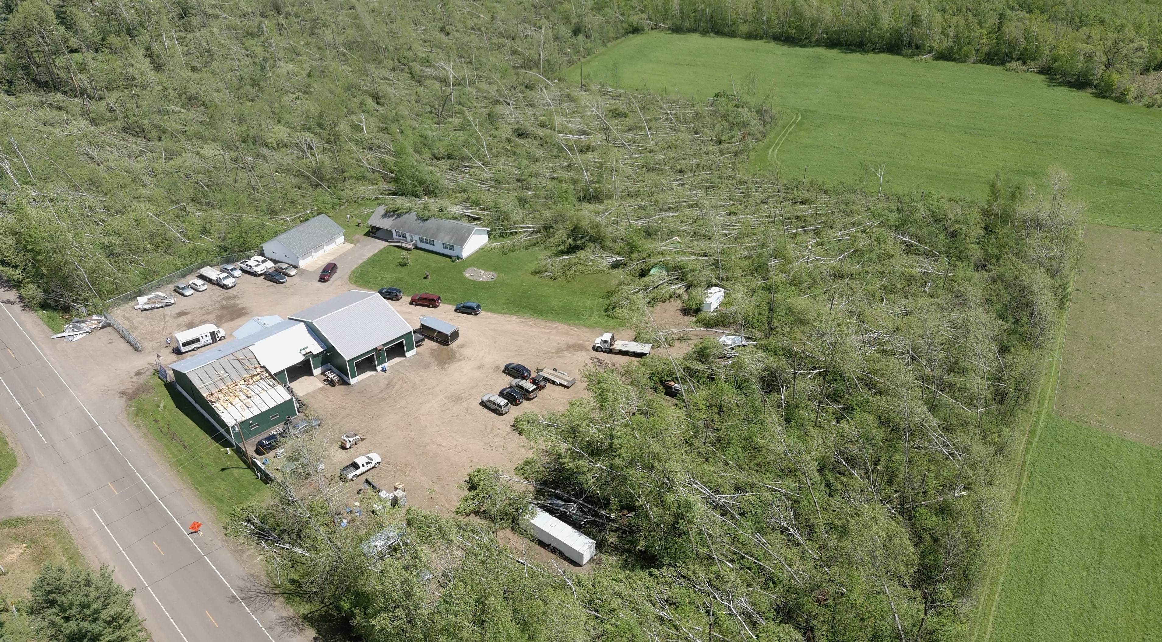
0646 PM Tornado Deer River 47.33N 93.79W
05/30/2022 Itasca MN NWS Storm Survey
Beginning of tornado. EF 1 rating with max
winds estimated 107 mph. Path length 2.5
miles. Max width 150 yards.
0647 PM Tstm Wnd Dmg Deer River 47.34N 93.79W
05/30/2022 Itasca MN Public
Garage completely collapsed with debris
strewn in Deer River.
0648 PM Tstm Wnd Dmg 5 S Grand Rapids 47.16N 93.52W
05/30/2022 Itasca MN Public
Several 8-10 inch diameter trees uprooted or
snapped.
0648 PM Tstm Wnd Dmg 3 S Cohasset 47.21N 93.63W
05/30/2022 Itasca MN Trained Spotter
Several trees approximately 8 to 10 inches
in diameter were blown over. A large tree
around 18 to 24 inches in diameter was also
blown down approximately 1 mile northwest of
the report location.
0648 PM Tstm Wnd Dmg 3 S Cohasset 47.21N 93.63W
05/30/2022 Itasca MN Trained Spotter
Several trees approximately 8 to 10 inches
in diameter were blown down. In addition, a
tree 18 to 24 inches in diameter was blown
over 1 mile northwest of this report
location.
0650 PM Tornado 2 NNW Deer River 47.37N 93.81W
05/30/2022 Itasca MN NWS Storm Survey
Estimated end for Deer River EF 1 tornado.
0650 PM Tstm Wnd Dmg 3 SW Cohasset 47.24N 93.67W
05/30/2022 Itasca MN Public
6-8 inch tree down and limbs snapped from a
picture on social media. Time estimated by
radar.
0652 PM Tstm Wnd Dmg 1 W Grand Rapids 47.23N 93.55W
05/30/2022 Itasca MN Public
Two 8 inch pine trees down. Time estimated
by radar.
0655 PM Hail 2 N Marcell 47.62N 93.69W
05/30/2022 E1.50 inch Itasca MN Public
Report via social media. Time estimated from
radar.
0655 PM Tstm Wnd Dmg Marcell 47.59N 93.69W
05/30/2022 Itasca MN Public
Report via social media with photo. Report
at least 5 balsam trees down that all fell
to the northwest. Numerous conifer branches
and tops down as well. Time estimated from
radar.
0656 PM Tstm Wnd Gst 1 SSE Grand Rapids 47.22N 93.52W
05/30/2022 M46 MPH Itasca MN AWOS
AWOS station KGPZ Grand Rapids Airport.
0700 PM Hail 1 WSW Coleraine 47.28N 93.44W
05/30/2022 E0.50 inch Itasca MN Public
Report from mPING.
0700 PM Hail 5 S La Prairie 47.15N 93.50W
05/30/2022 E0.75 inch Itasca MN Public
Report from mPING.
0701 PM Hail Coleraine 47.29N 93.43W
05/30/2022 U1.00 inch Itasca MN Public
Report from mPING.
0709 PM Tstm Wnd Dmg 13 ESE Marcell 47.52N 93.42W
05/30/2022 Itasca MN Public
Balsam trees, at least 5 down. Estimated
diameter from photo of 6 to 8 inches. Time
estimated by radar.
0728 PM Tstm Wnd Gst Littlefork 48.40N 93.56W
05/30/2022 E40 MPH Koochiching MN Mesonet
Tempest Backyard Weather Station.
0732 PM Tstm Wnd Dmg 1 WNW Littlefork 48.40N 93.57W
05/30/2022 Koochiching MN Law Enforcement
Trees down near US 71 and State Highway 65.
Time estimated from radar.
0732 PM Tstm Wnd Dmg 3 NW Stony Brook 47.77N 93.13W
05/30/2022 Itasca MN Public
Photos via social media of several trees
uprooted or broken. Tree debris was
scattered over roadway. Time estimated from
radar.
0738 PM Tstm Wnd Dmg 4 E Henriette 45.87N 93.04W
05/30/2022 Pine MN Public
Several large trees down, including one on a
camper and another 16-18 inches in diameter
estimated that fell on a house causing
significant damage to the roof on the north
side of Pokegama Lake. Time estimated by
radar.
0740 PM Tstm Wnd Dmg 2 N Stony Brook 47.77N 93.10W
05/30/2022 Itasca MN Public
Photos via social media report of numerous
medium to large trees snapped at the base.
Time estimated from radar.
0740 PM Tstm Wnd Dmg 1 W Togo 47.82N 93.17W
05/30/2022 Itasca MN Public
Sherriff department reports tree down on
power line along Highway 1. Time estimated
from radar.
0742 PM Tstm Wnd Dmg Pine City 45.83N 92.97W
05/30/2022 Pine MN Law Enforcement
Trees down.
0742 PM Tstm Wnd Dmg 5 NNE Snake Trail 47.78N 93.02W
05/30/2022 St. Louis MN Law Enforcement
Multiple trees down highway 22 and 5. Time
estimated by radar.
0744 PM Tstm Wnd Dmg Beroun 45.91N 92.95W
05/30/2022 Pine MN Law Enforcement
Trees down.
0745 PM Tstm Wnd Dmg International Falls 48.59N 93.41W
05/30/2022 Koochiching MN Public
Large pine tree down. Report from social
media. Time estimated by radar.
0745 PM Tstm Wnd Dmg Side Lake 47.67N 93.02W
05/30/2022 St. Louis MN Law Enforcement
Sherriff Department reports several trees
down and over power lines. Time estimated
from radar.
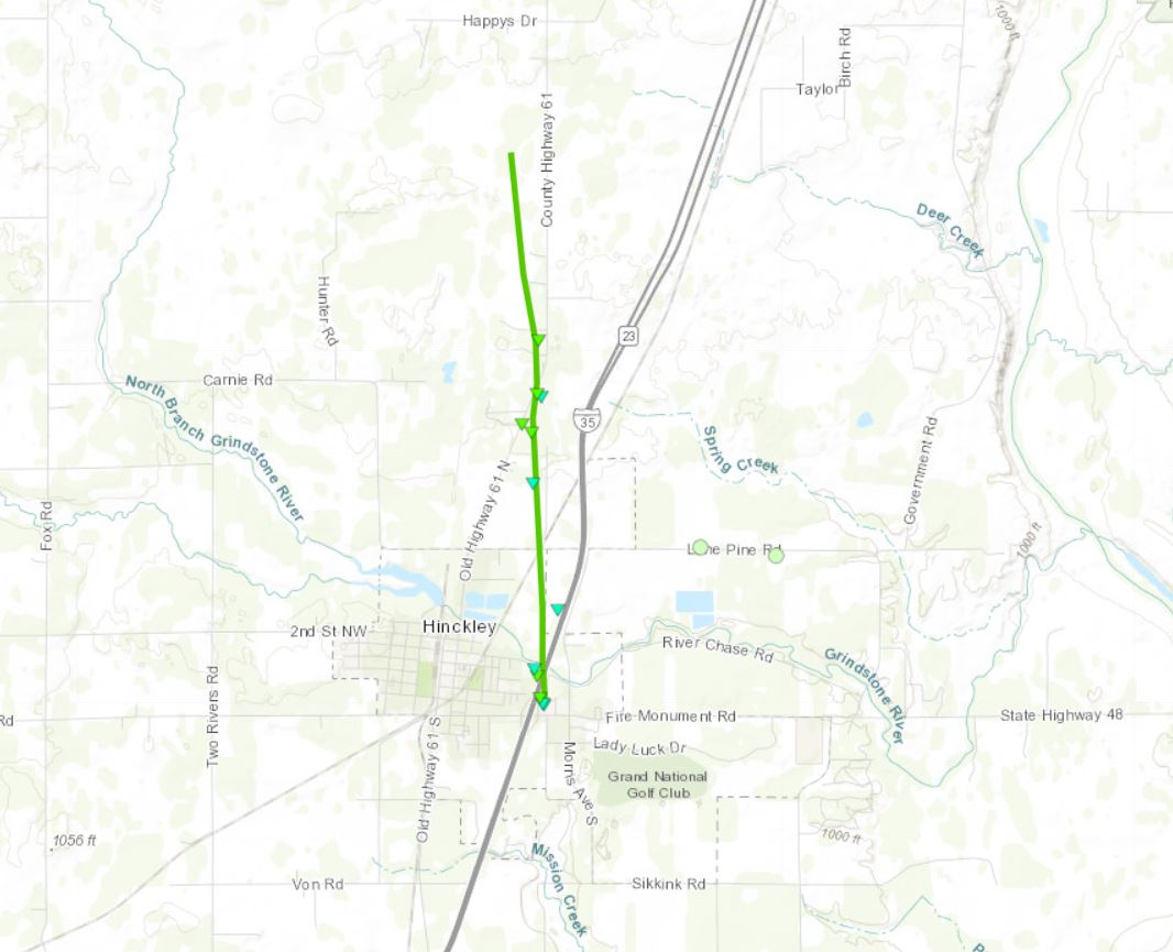
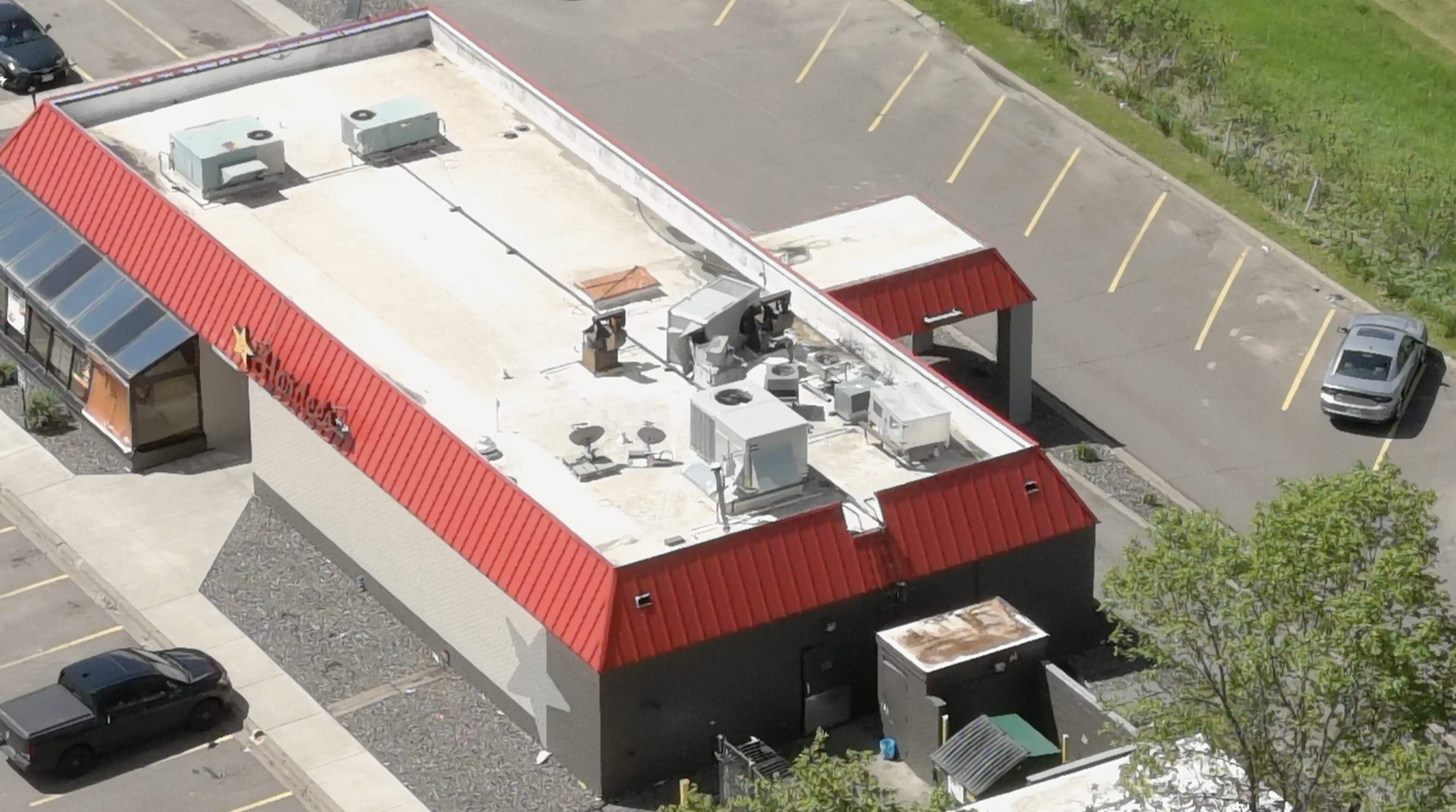
0750 PM Tornado Hinckley 46.01N 92.93W
05/30/2022 Pine MN NWS Storm Survey
Preliminary beginning of Hinckley EF-1
tornado. Max estimated winds of 95 mph.
0750 PM Tstm Wnd Dmg Hinckley 46.02N 92.93W
05/30/2022 Pine MN Fire Dept/Rescue
Numerous trees and power lines down in
Hinckley.
0750 PM Tstm Wnd Dmg 6 NW Friesland 46.14N 93.02W
05/30/2022 Pine MN Public
Corrects previous tstm wnd dmg report from 6
NW Friesland. 15 inch diameter tree snapped
halfway up. Time estimated from radar.
0750 PM Tstm Wnd Dmg Hinckley 46.01N 92.93W
05/30/2022 Pine MN Public
Wind damage and trees down at Holiday
station in Hinckley.
0752 PM Tstm Wnd Dmg 1 NNE Hinckley 46.03N 92.92W
05/30/2022 Pine MN Public
Trees down just north of Hinckley on I-35.
Report relayed by social media. Time
estimated by radar. Location estimated.
0752 PM Tstm Wnd Dmg 3 S Bruno 46.24N 92.67W
05/30/2022 Pine MN Public
Report via social media with pictures.
Numerous large trees uprooted and causing
damage to outbuildings. Time estimated via
radar.
0752 PM Tstm Wnd Dmg 1 N Cloverdale 46.03N 92.74W
05/30/2022 Pine MN Public
28 foot camper lifted off its foundation and
destroyed. Many trees snapped due to strong
winds. Location is approximate. Time
estimated by radar.
0754 PM Tornado 2 S Friesland 46.06N 92.93W
05/30/2022 Pine MN NWS Storm Survey
Preliminary end of Hinckley EF-1 tornado
path. Estimated winds of 95 mph.
0755 PM Tstm Wnd Dmg Sandstone 46.13N 92.86W
05/30/2022 Pine MN Public
Report via social media with photos.
Numerous uprooted trees and several downed
power lines.
0800 PM Hail 1 SW Orr 48.05N 92.83W
05/30/2022 M1.50 inch St. Louis MN Public
Burst of large hail mixed with widespread
3/4 inch diameter hail.
0800 PM Tstm Wnd Dmg 6 N Cook 47.94N 92.67W
05/30/2022 St. Louis MN Public
1 tree down in yard and a few larger
branches came down. 4 inch diameter
estimated by the photo from social media.
Time estimated by radar.
0800 PM Tstm Wnd Dmg 3 E Orr 48.06N 92.77W
05/30/2022 St. Louis MN CO-OP Observer
Swath of trees about 30 yards across is down
through the woods along Highway 23. Observer
reports it looks like someone took a huge
mower to the forest.
0800 PM Tstm Wnd Dmg Linden Grove 47.86N 92.87W
05/30/2022 St. Louis MN Law Enforcement
Sherriff department reports multiple trees
down, several over power lines. Time
estimated from radar.
0800 PM Tstm Wnd Dmg 4 SE Danbury 45.96N 92.31W
05/30/2022 Burnett WI Trained Spotter
Reports some small trees down on property
with larger trees blocking entire town roads
in the area. Time estimated from radar.
0809 PM Hail Orr 48.07N 92.82W
05/30/2022 E1.00 inch St. Louis MN Public
Report relayed by media.
0816 PM Tstm Wnd Dmg Cook 47.85N 92.69W
05/30/2022 St. Louis MN Law Enforcement
Sherriff department reports three power
poles snapped near Cook and several trees
down over power lines. Time estimated from
radar.
0820 PM Tstm Wnd Dmg 5 NNE Cook 47.92N 92.65W
05/30/2022 St. Louis MN Law Enforcement
Sherriff Department reports tree down over
power line. Time estimated from radar.
0829 PM Tstm Wnd Dmg 2 WSW Holyoke 46.46N 92.42W
05/30/2022 Carlton MN Public
Tree limbs broken. Time estimated from
radar.
0905 PM Tstm Wnd Dmg Bennett 46.45N 91.85W
05/30/2022 Douglas WI Public
Lawn furniture and a 50 pound grill blown
across across the yard. Temporarily lost
power. Time estimated by radar.
0910 PM Tstm Wnd Dmg Lake Nebagamon 46.51N 91.69W
05/30/2022 Douglas WI Public
Report from Facebook. Large pine trees
snapped and causing damage to garage and
outbuilding. Time estimated from radar.
0910 PM Tstm Wnd Dmg Babbitt 47.71N 91.95W
05/30/2022 St. Louis MN Law Enforcement
Sheriff department reports tree down over
the roadway. Time estimated from radar.
&&
$$
Environment
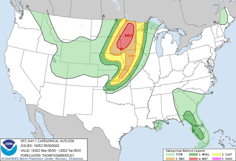
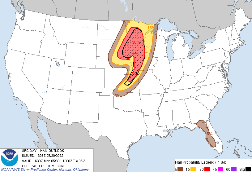
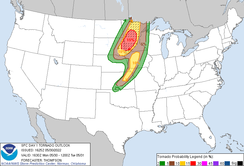
   SPC AC 301625

   Day 1 Convective Outlook
   NWS Storm Prediction Center Norman OK
   1125 AM CDT Mon May 30 2022

   Valid 301630Z - 311200Z

   ...THERE IS A MODERATE RISK OF SEVERE THUNDERSTORMS THIS
   AFTERNOON/EVENING FROM EASTERN SD INTO MN...

   ...SUMMARY...
   Numerous severe thunderstorms are forecast across parts of the
   Northern Plains and Upper Mississippi Valley, with more scattered to
   isolated activity southward into the central Plains today into
   tonight. Large to giant hail, 60-80 mph gusts, and a few
   long-tracked, intense tornadoes are possible.

   ...A substantial threat for severe storms with all hazards is
   expected this afternoon/evening from eastern South Dakota into
   Minnesota...

   ...Eastern SD into MN though late evening...
   A midlevel shortwave trough and associated 70-90 kt midlevel jet
   will progress quickly north-northeastward from western KS/NE toward
   the upper MS Valley by tonight.  An associated 992 mb surface low in
   central NE as of late morning will develop quickly
   north-northeastward across eastern SD to near the ND/MN border by
   early tonight.  Scattered elevated storms, some with large hail,
   will likely persist through the day in the warm advection zone to
   the north of the warm front across eastern SD into southwestern MN.
   However, the warm sector with mid-upper 60s dewpoints now across
   eastern NE/western IA will spread northward during the day, with
   increasing potential for surface-based storm development near and
   just ahead of the surface cyclone and ejecting midlevel trough by
   midday/early afternoon.

   It appears the convection will begin as clusters by midday across
   east/southeast SD, and expand quickly northeastward into
   central/northern MN by late afternoon/evening.  All hazards can be
   expected with the surface-based storms during the afternoon, in an
   environment favorable for fast-moving supercells.  However, there
   are some concerns about mixed convective mode/bowing segments given
   potential storm interactions and strong forcing for ascent.
   Deep-layer vertical shear will be quite strong (effective shear in
   excess of 65 kt), with long hodographs and low-level, clockwise
   curvature (effective SRH of 300-400 m2/s2).  These wind profiles, in
   combination with midlevel lapse rates greater than 8 C/km and MLCAPE
   of 2000-3000 J/kg, will support the threat for a few long-tracked,
   intense tornadoes and very large hail with any semi-discrete
   supercells.  As previously mentioned, there will also be some
   potential for storm interactions and upscale growth into line
   segments capable of producing significant outflow gusts up to 80
   mph, given the very strong environmental wind profiles.

   ..Thompson/Bentley.. 05/30/2022
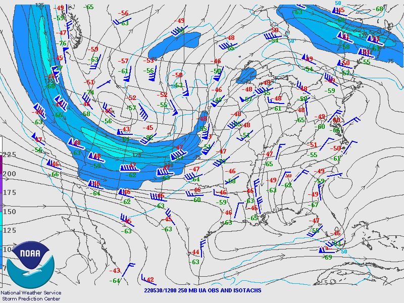
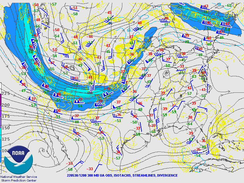
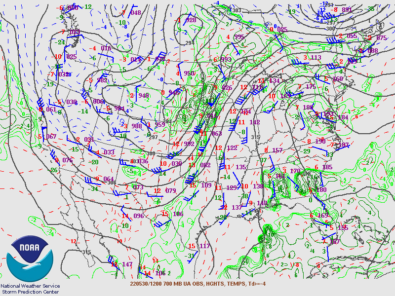
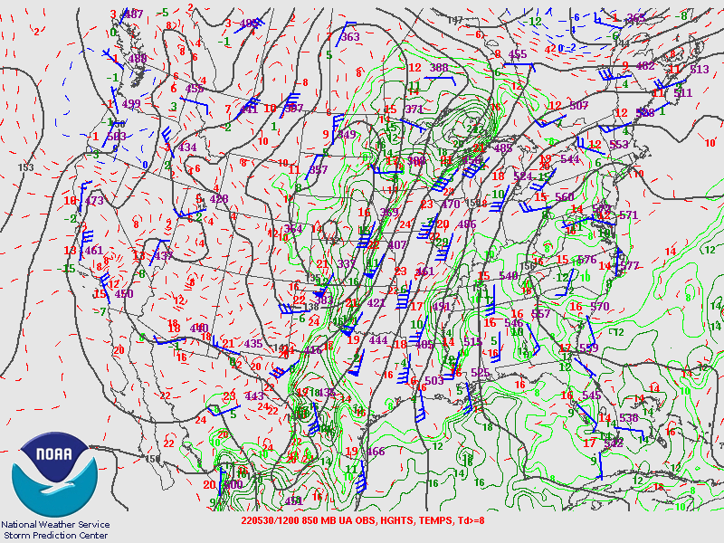
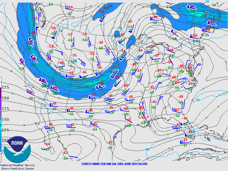
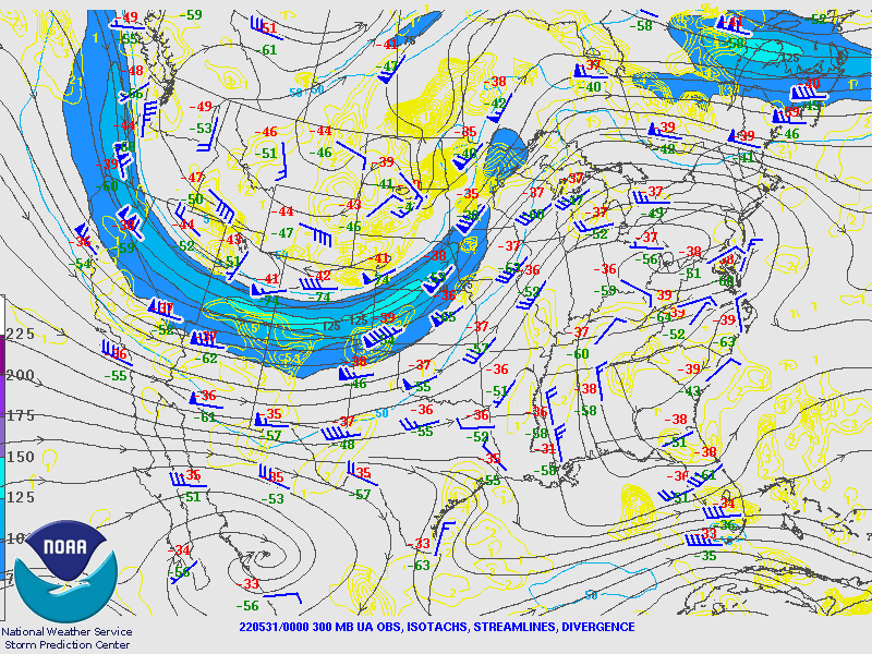
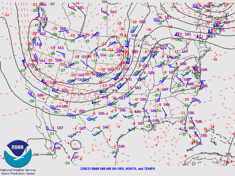
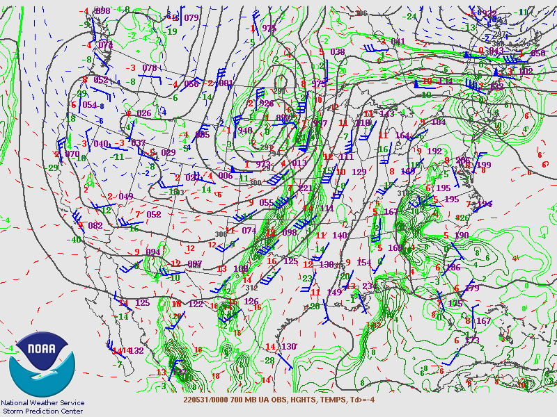
12z (7AM CDT) Upper Air Analysis
 |
 |
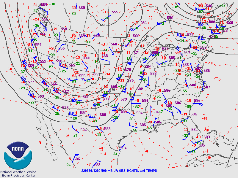 |
| 250mb | 300mb | 500mb |
 |
 |
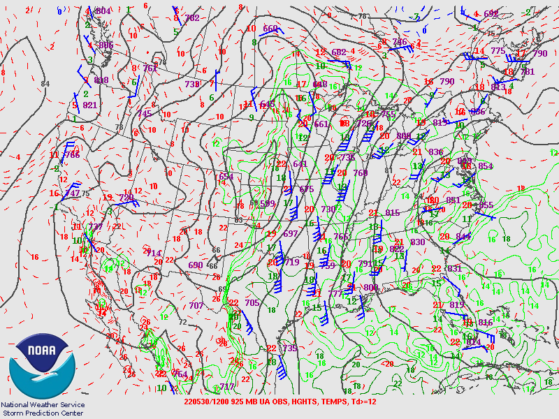 |
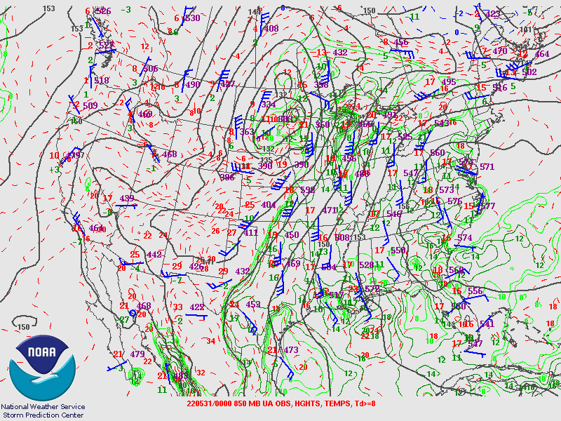
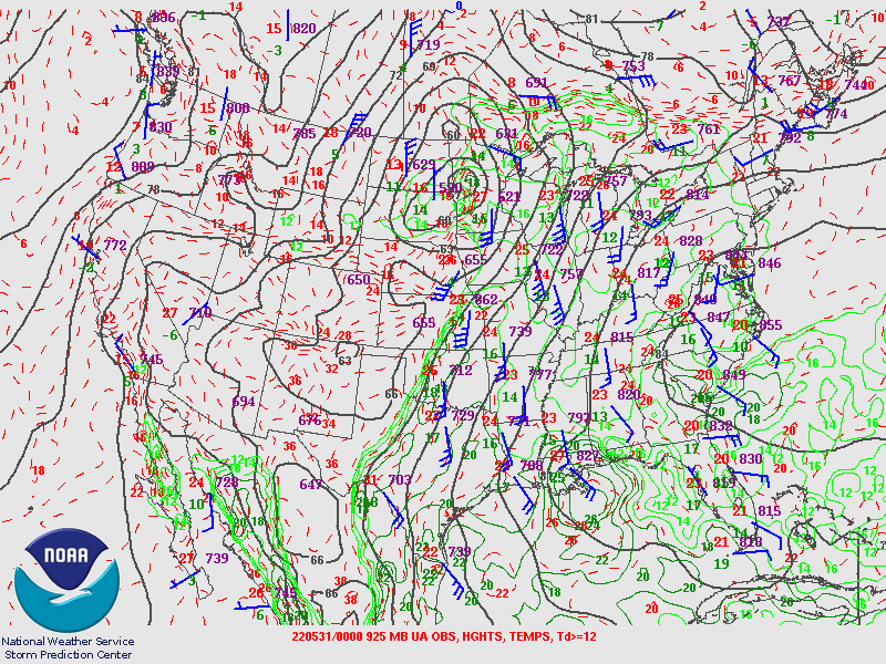
| 700mb | 850mb | 925mb |
00z (7PM CDT) Upper Air Analysis
 |
 |
 |
| 250mb | 300mb | 500mb |
 |
 |
 |
| 700mb | 850mb | 925mb |
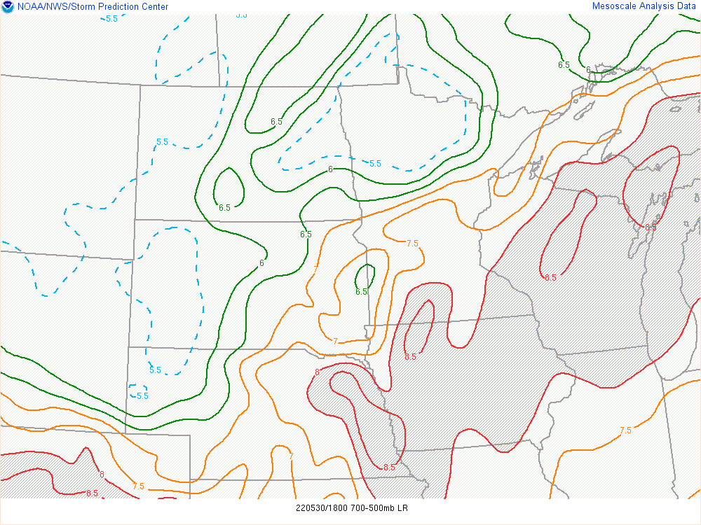
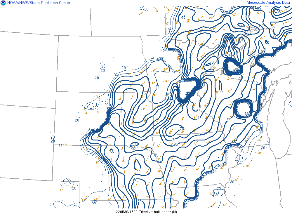
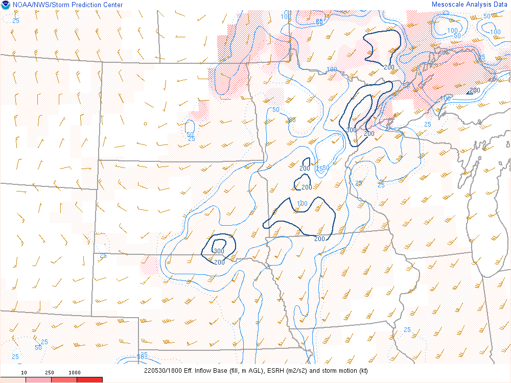
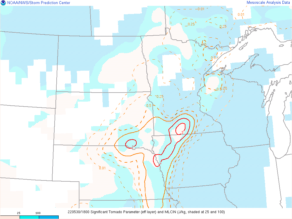
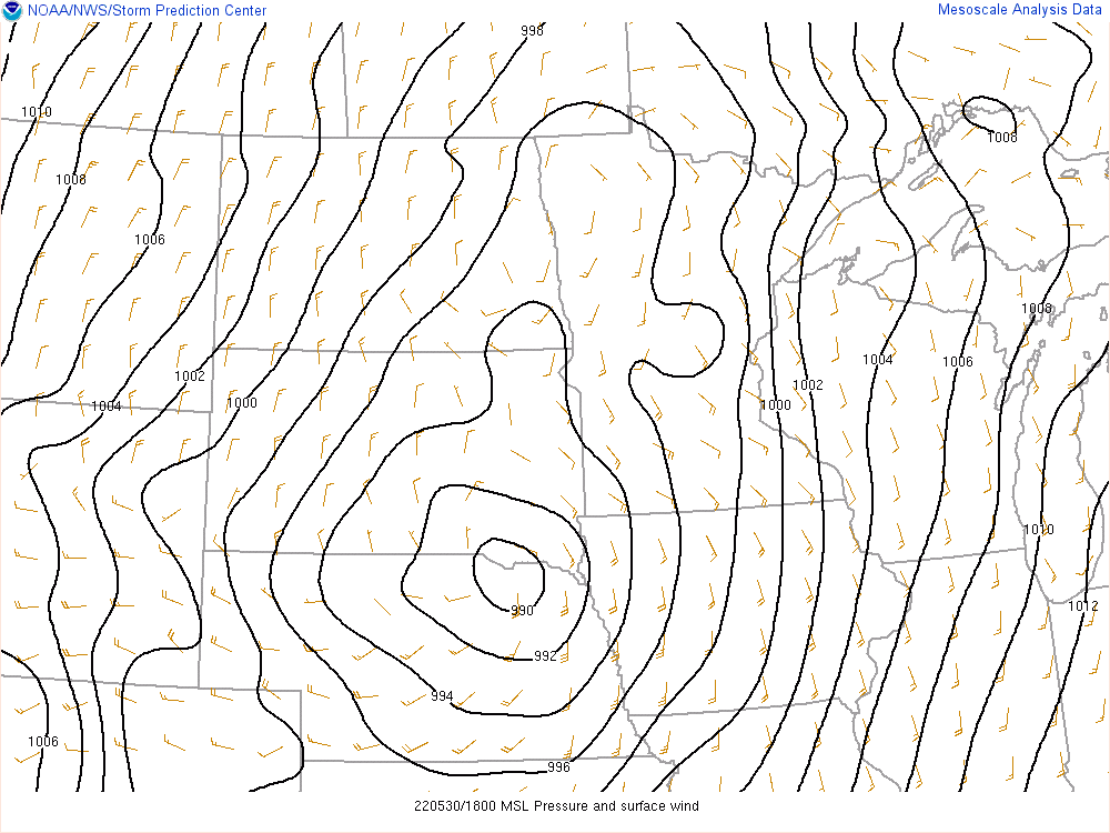
Near-storm Environment During the Event
 |
 |
 |
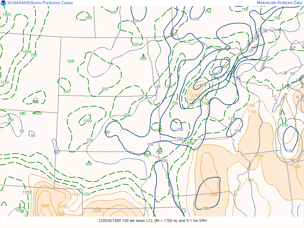 |
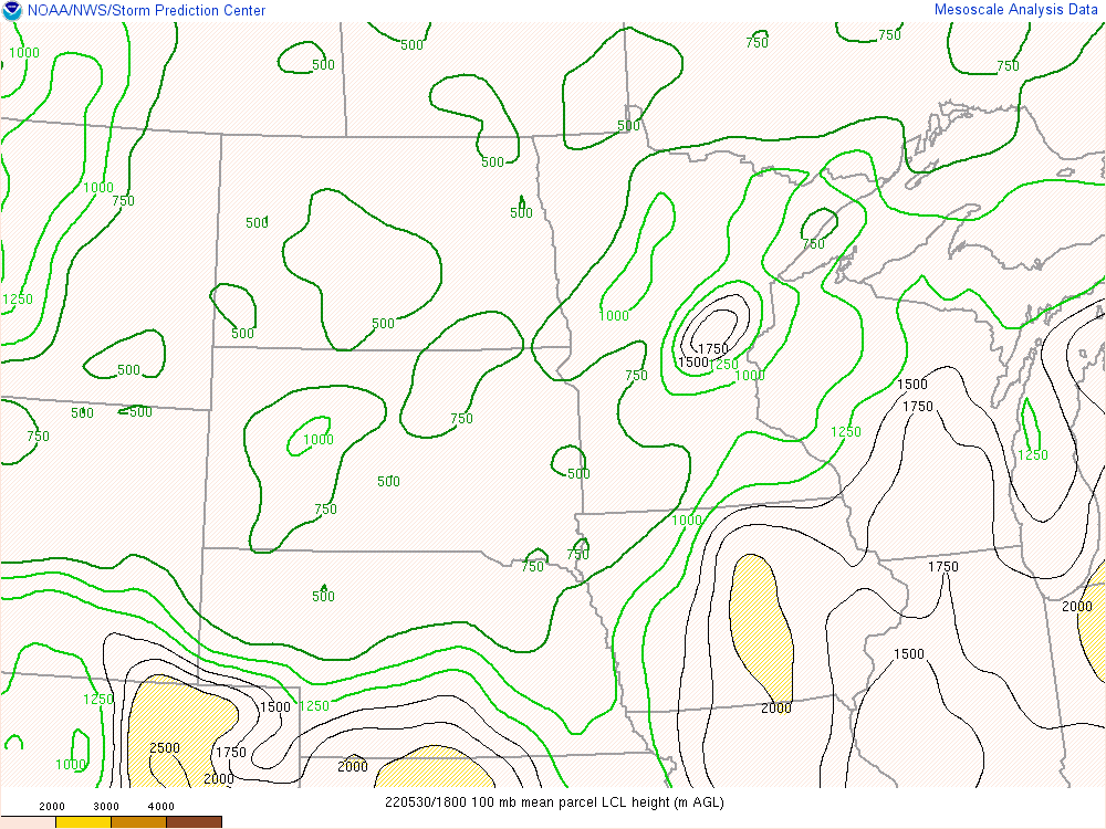
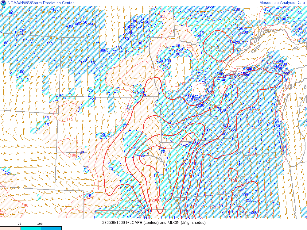
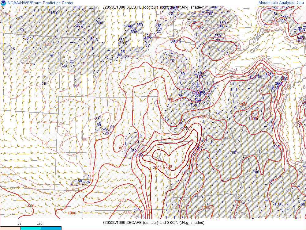
| 700-500mb Lapse Rates | Effective Bulk Shear | LCL Heights | LCL Heights and 0-1km SRH |
 |
 |
 |
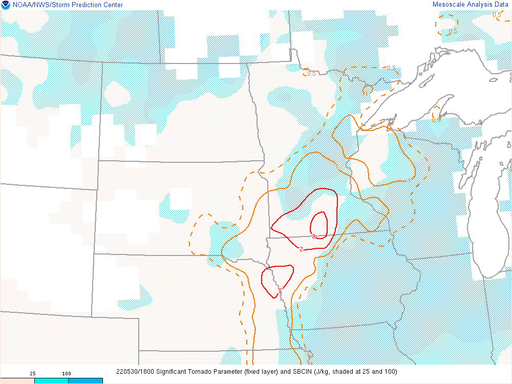 |
| MLCAPE and MLCIN | SBCAPE and SBCIN | Effective SRH | Significant Tornado Parameter |
 |
 |
 |
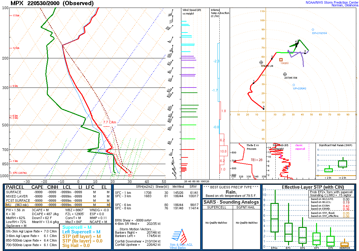 |
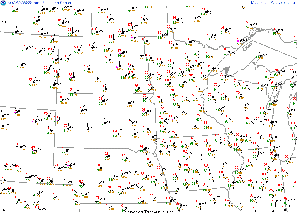
| Effective Layer STP | MSL Pressure and Surface Wind | Surface Plot | 20z MPX Sounding |
SPC Day 1 Outlooks
 |
 |
 |
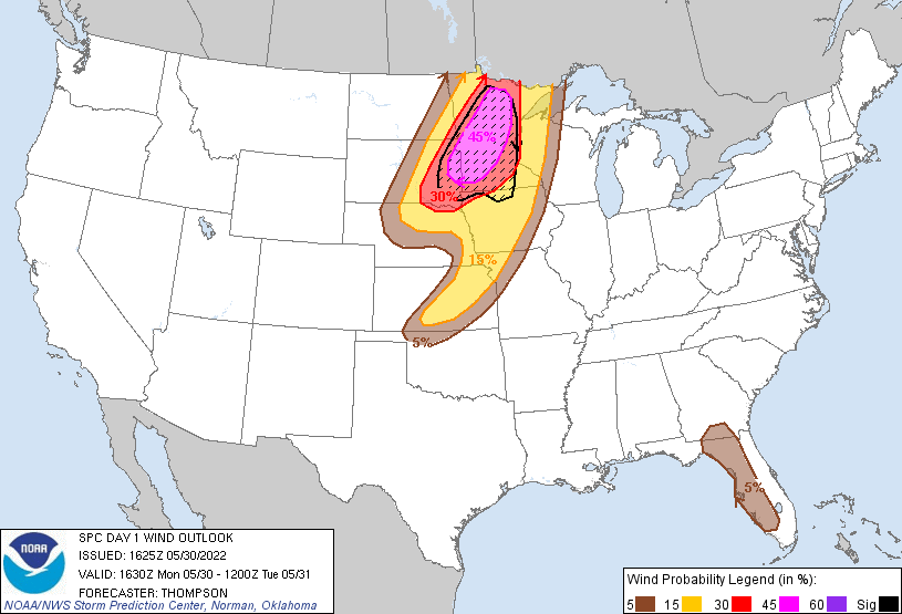 |
| 1630z Day 1 Categorical Outlook | 1630z Day 1 Hail Outlook | 1630z Day 1 Tornado Outlook | 1630z Day 1 Wind Outlook |
 |
Media use of NWS Web News Stories is encouraged! Please acknowledge the NWS as the source of any news information accessed from this site. |
|