
Heavy to excessive rainfall may bring flooding to parts of Arizona, New Mexico, Florida, North Carolina, and Virginia Wednesday. Recently burned areas will be particularly vulnerable to flash flooding. Gusty winds and low humidity will bring critical fire weather to parts of the Northwest U.S. and central Alaska on Wednesday where Red Flag Warnings are in effect. Read More >
Overview
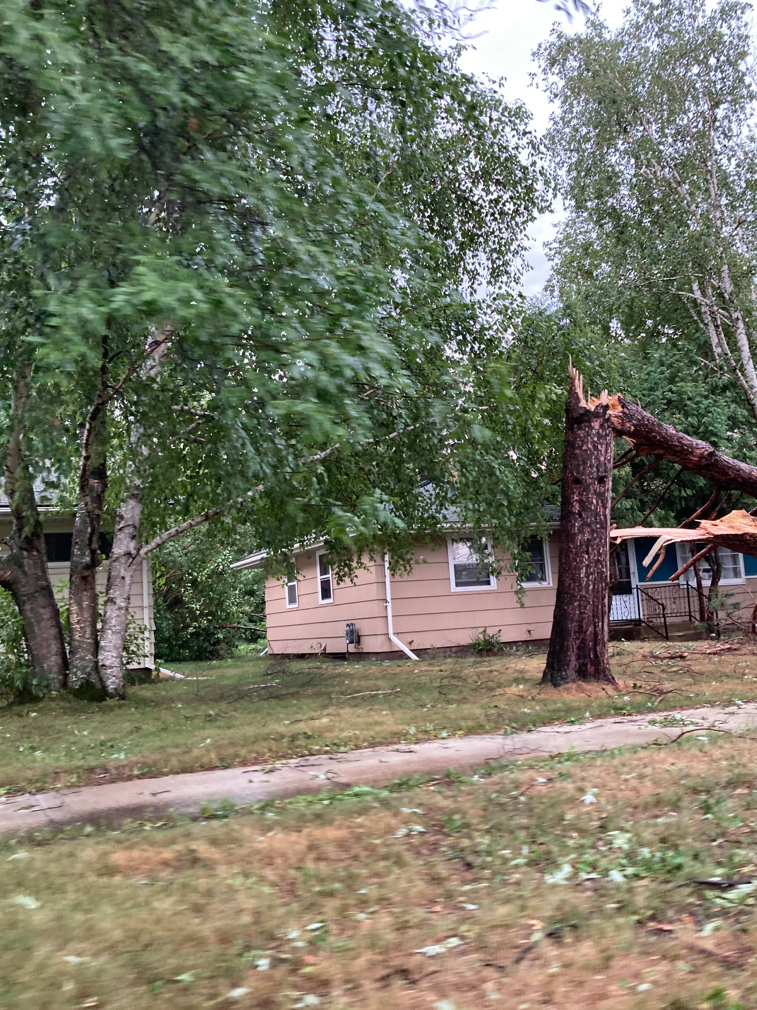
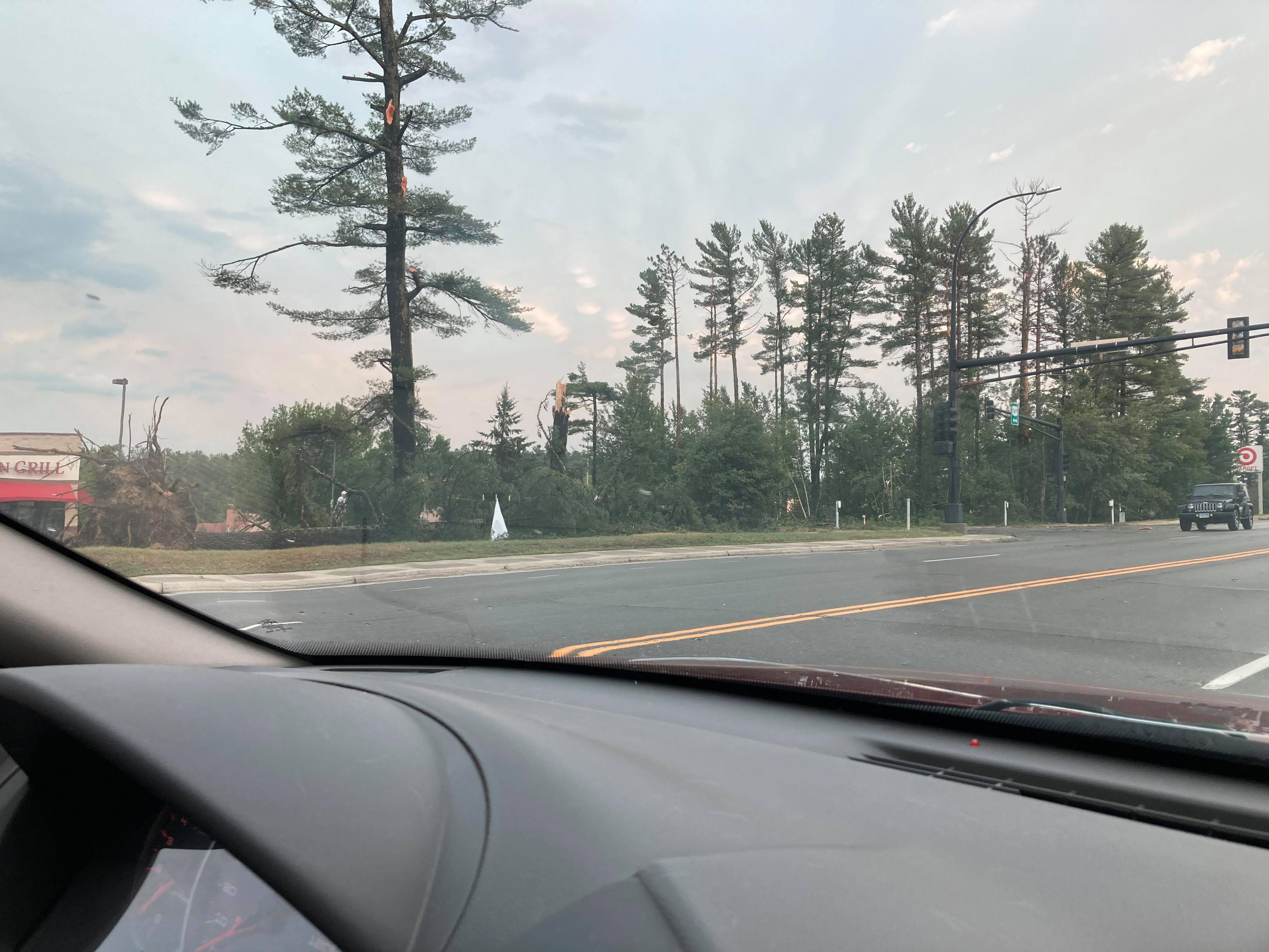
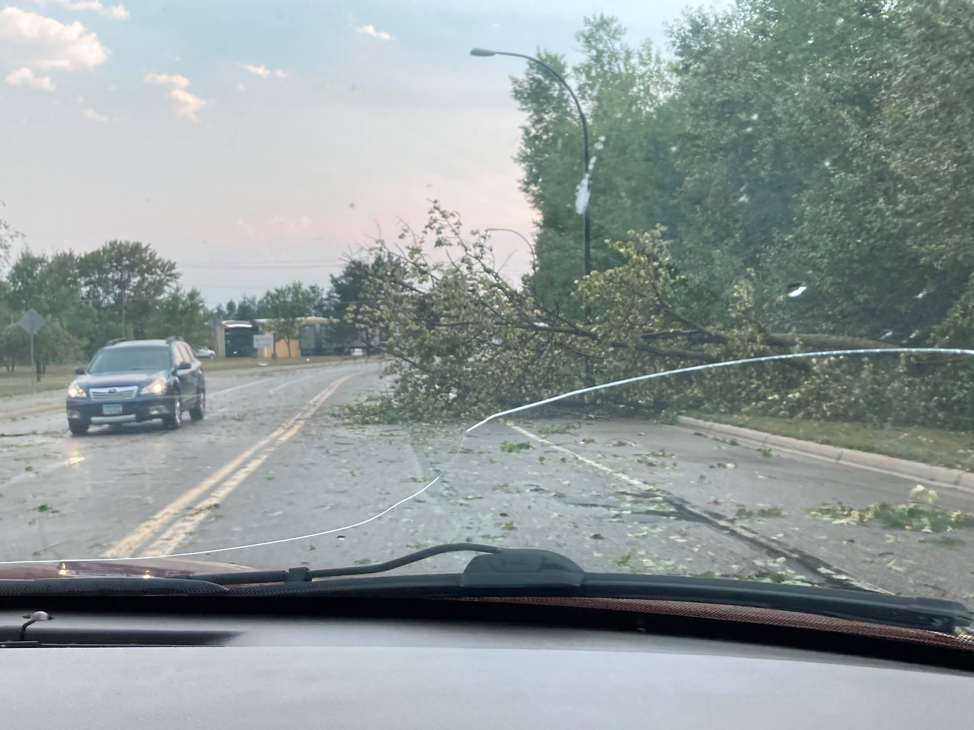
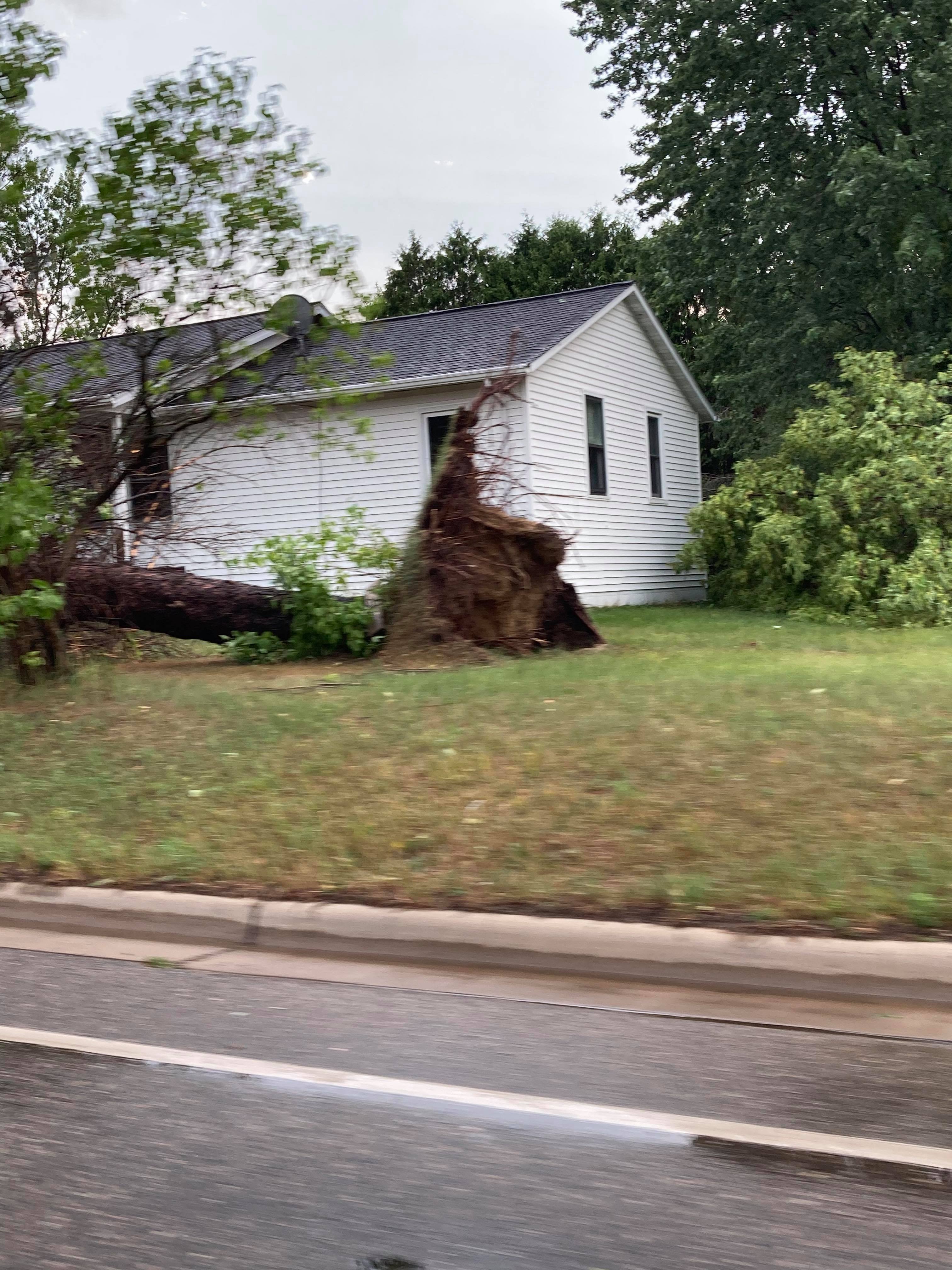
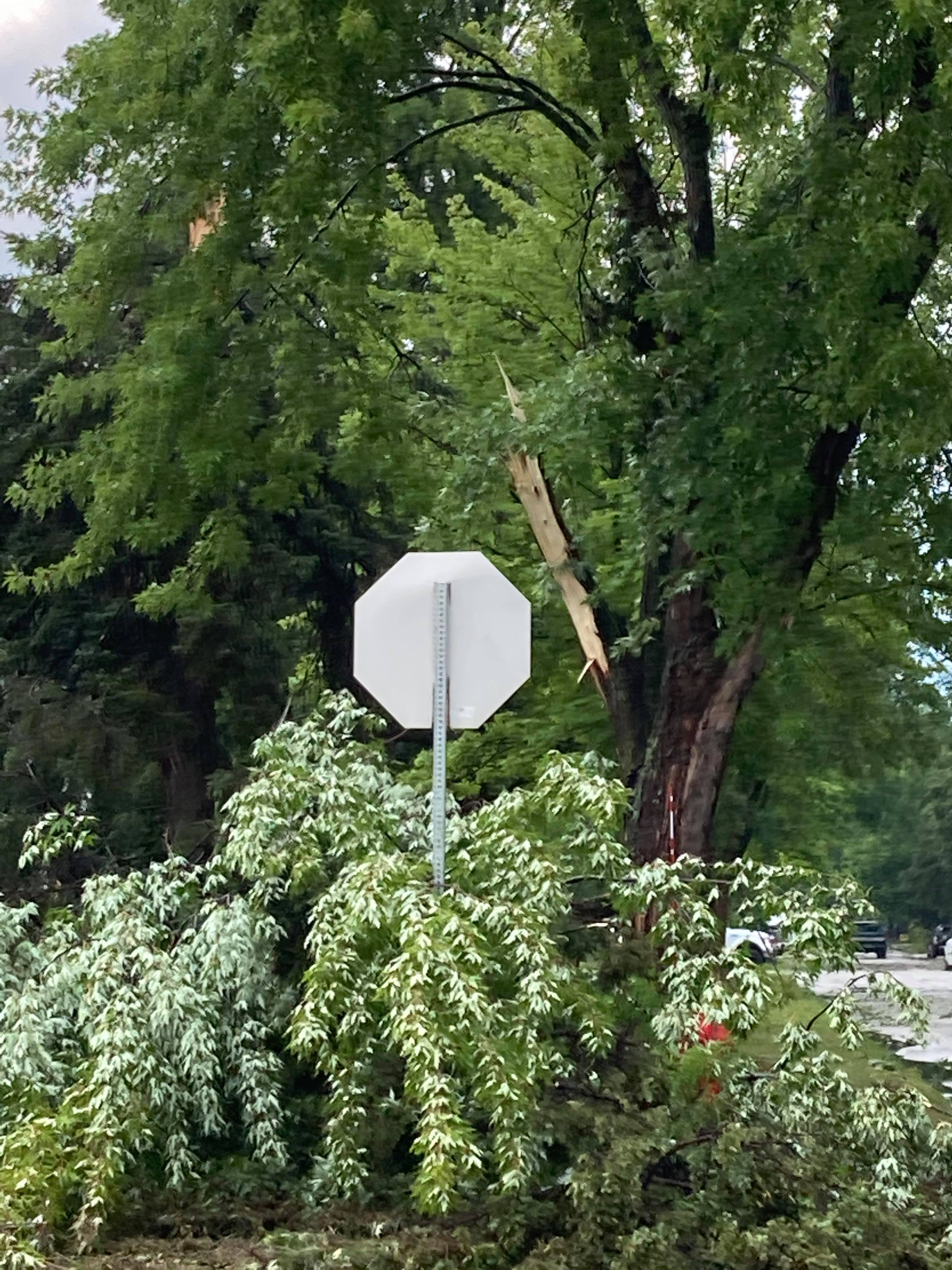
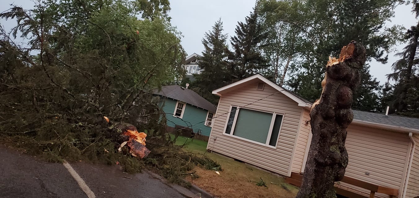
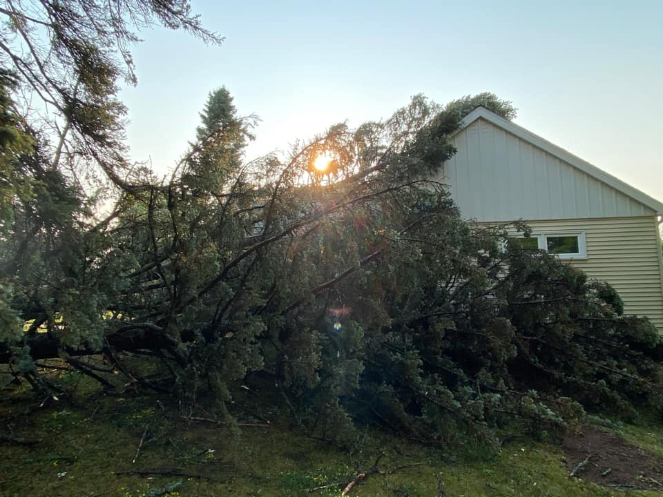
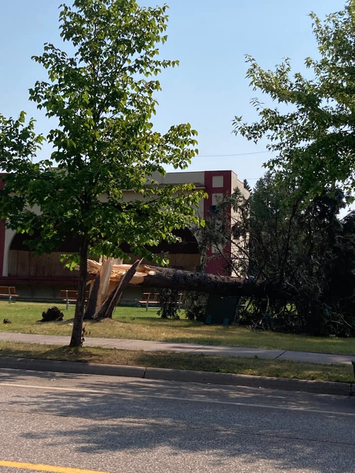
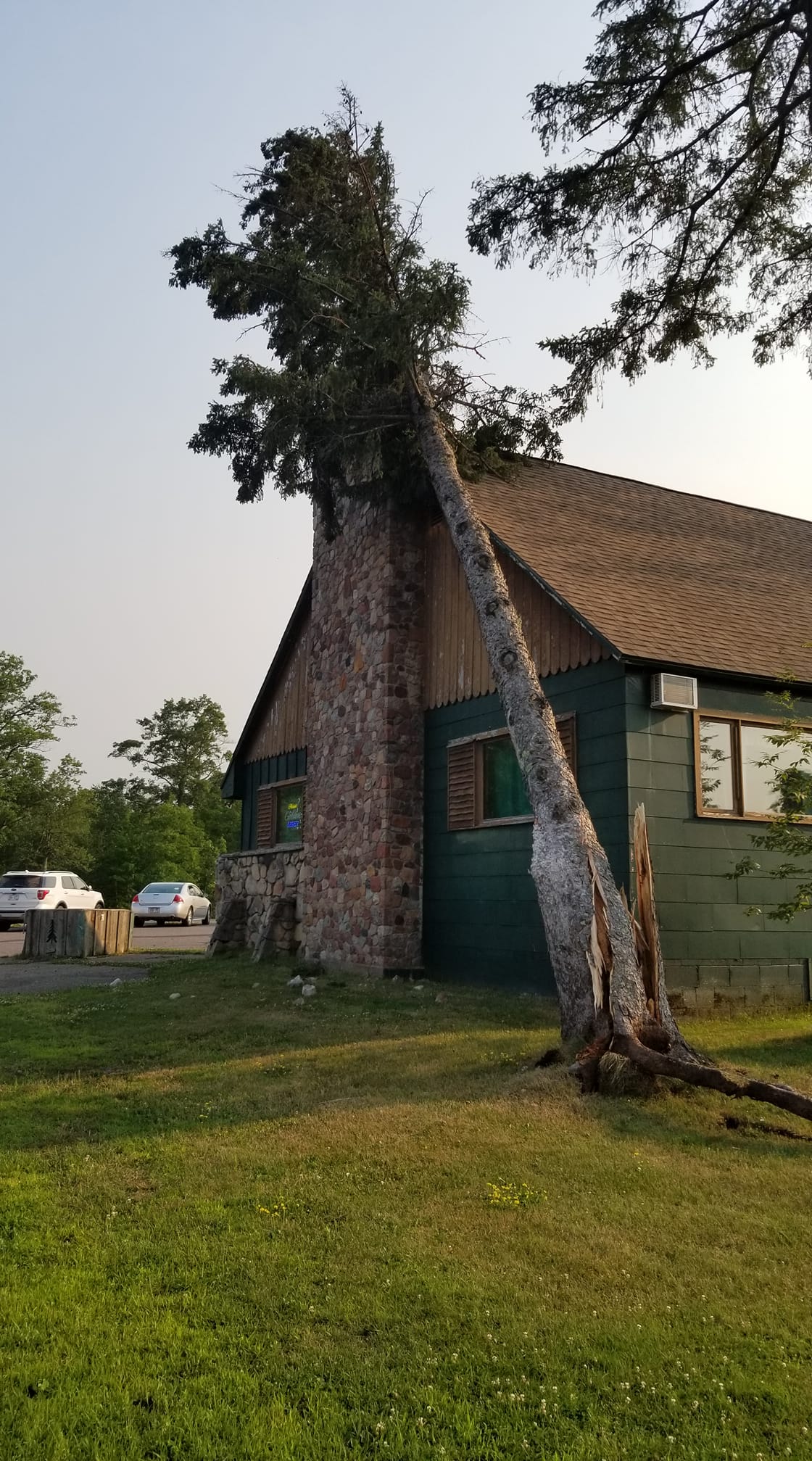
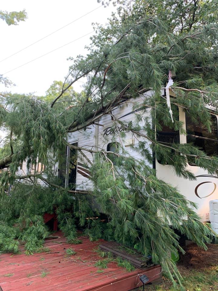
A strong area of low pressure north of the International Border lifted a warm front across the Northland the morning of July 26, 2021, and brought a very warm, moist airmass into the region. As the cold front approached during the late afternoon and evening hours, storms developed across north- central Minnesota in this highly-sheared and very unstable airmass. The first storms developed near Red Lake in Grand Fork's CWA and produced a trio of tornadoes before entering into the Duluth CWA in Cass County and producing very large hail near Bena. Storms then moved through the Grand Rapids area producing extensive tree damage before continuing to move to the southeast through the Twin Ports into northwest Wisconsin producing wind damage and hail.
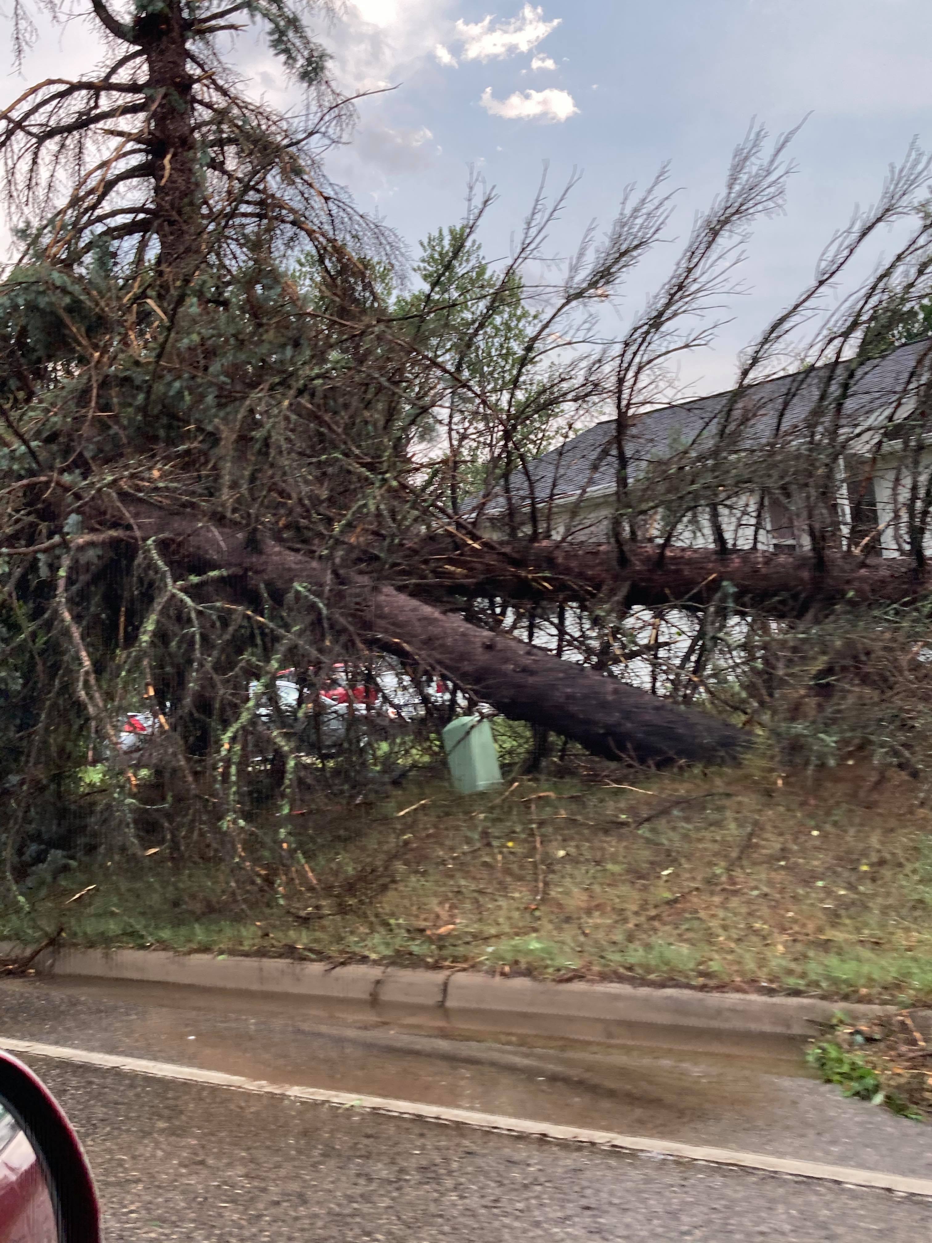
More storms developed behind this initial wave and weren't severe initially. However, once reaching the Twin Ports area, they intensified across northern Douglas County in northwest Wisconsin and brought very large hail to the Poplar area along with areas of tree damage across portions of Douglas, Bayfield, Sawyer and Iron counties before pushing out of the CWA. These storms also produced rainfall of 1.5" to almost 3" near Hayward, although no flooding was reported.
This event occurred with the Duluth radar being offline due to technical issues. Storm spotters were indispensable for this event along with the KMVX and KMPX radars. NWS Duluth would like to thank the spotters for their assistance in this event.
Photos & Video
 |
 |
 |
 |
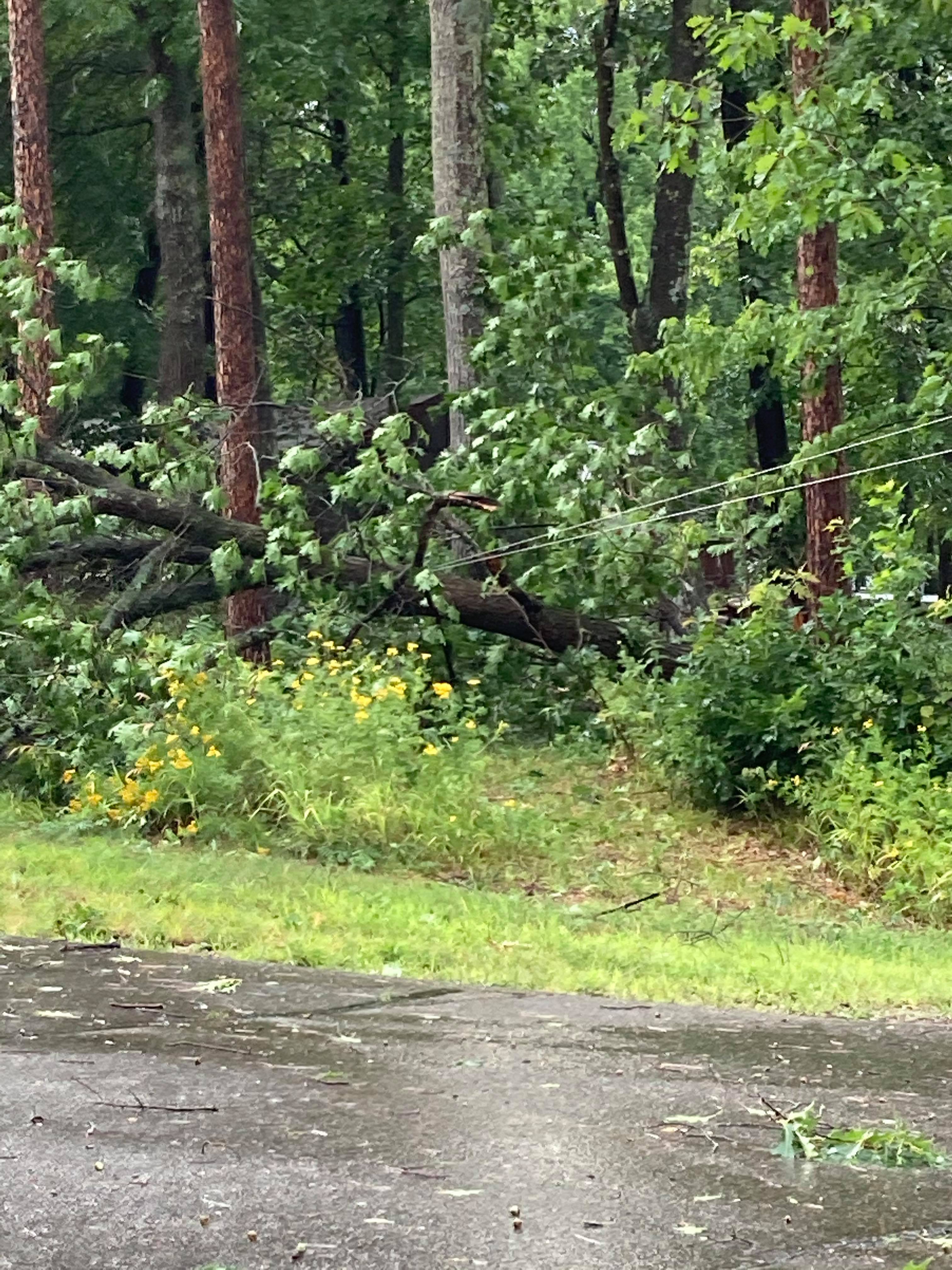
| Tree damage in Cohasset (Ryan Jensen photo) |
Tree damage in Cohasset (Ryan Jensen photo) |
Tree damage in Grand Rapids (Ryan Jensen photo) |
Tree damage in Grand Rapids (Ryan Jensen photo) |
 |
 |
 |
 |
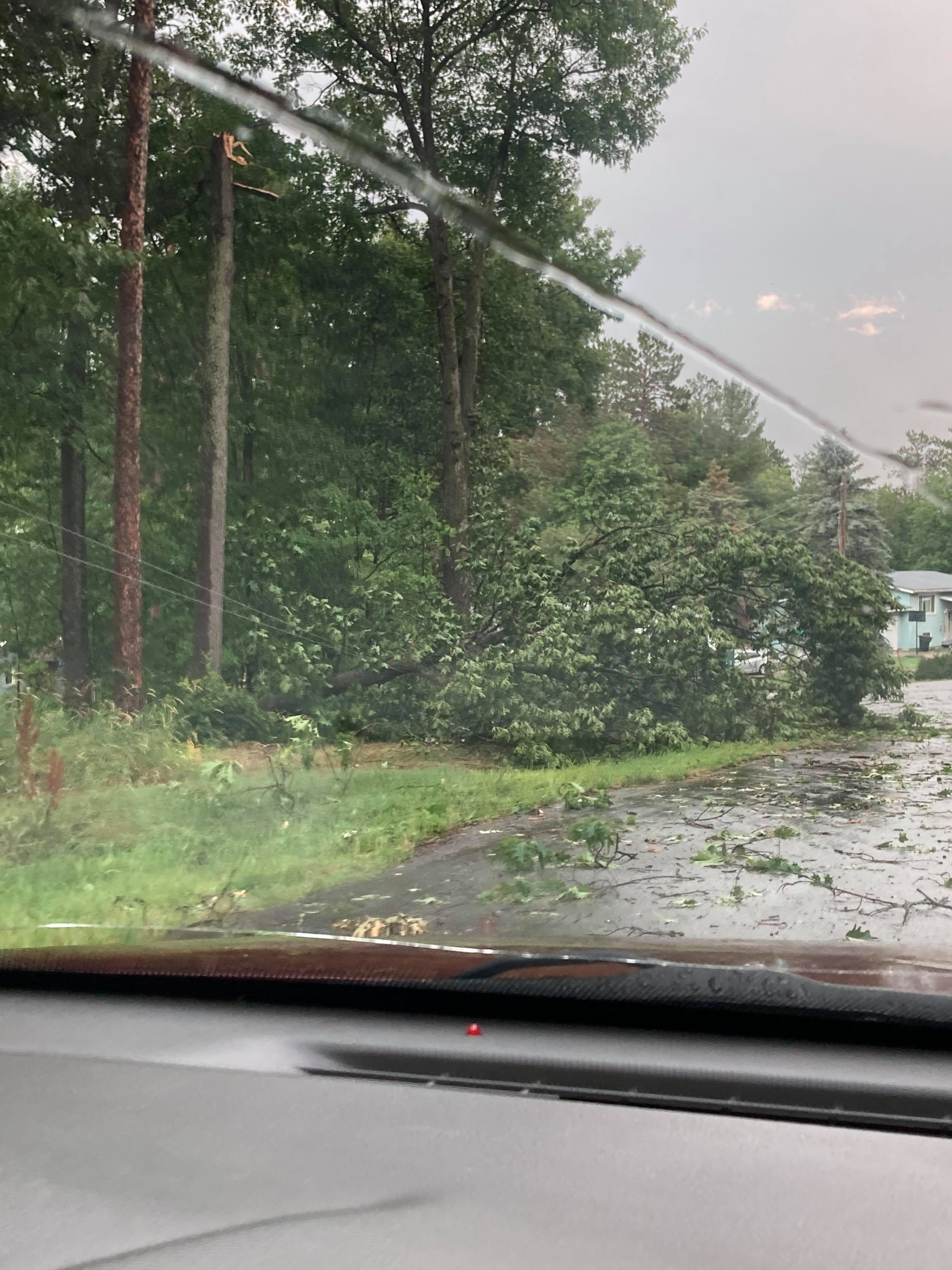
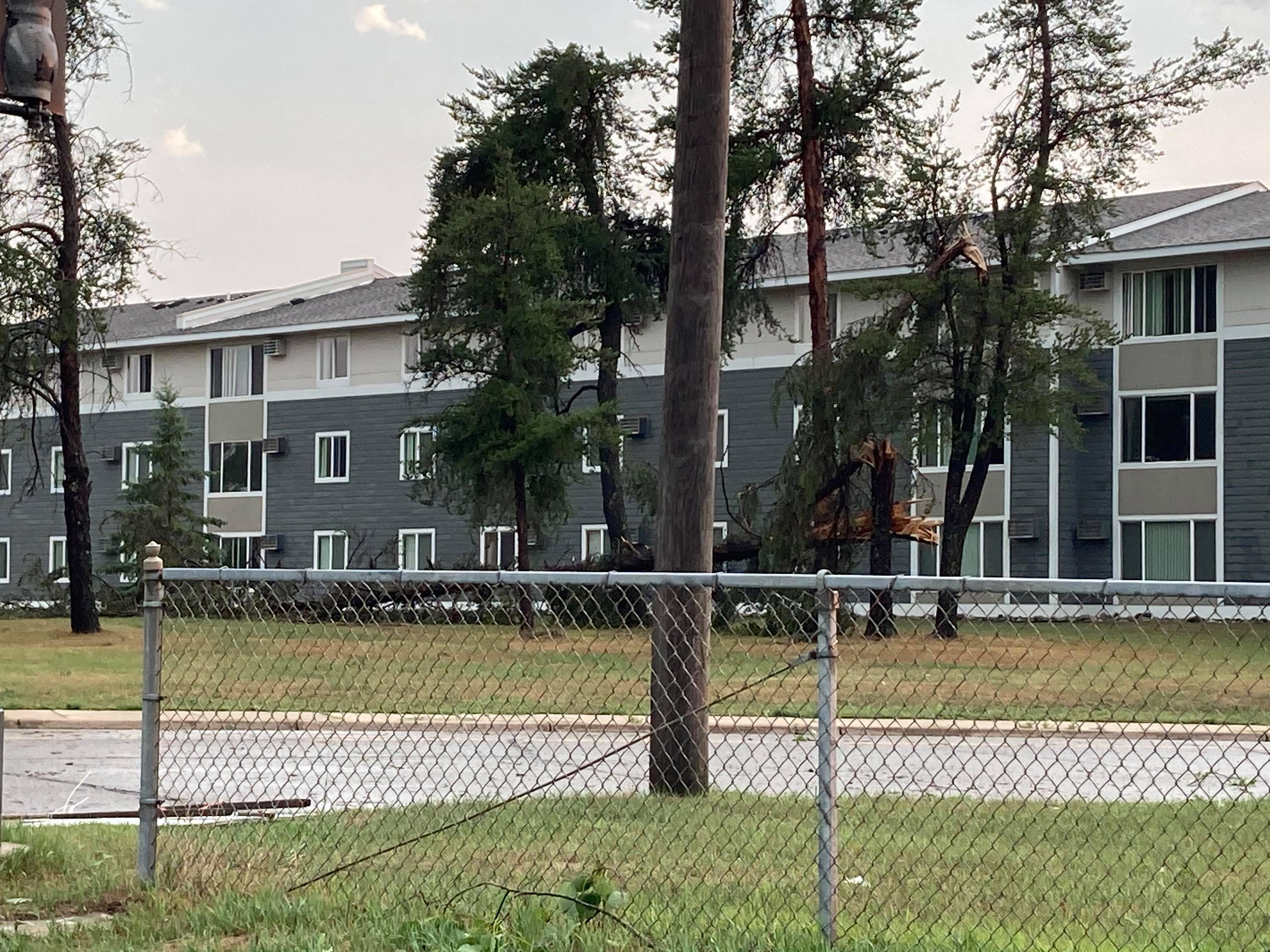
| Tree damage in Grand Rapids (Ryan Jensen photo) |
Tree damage in Grand Rapids (Ryan Jensen photo) |
Tree damage in Grand Rapids (Ryan Jensen photo) |
Tree damage in Grand Rapids (Ryan Jensen photo) |
 |
 |
 |
 |
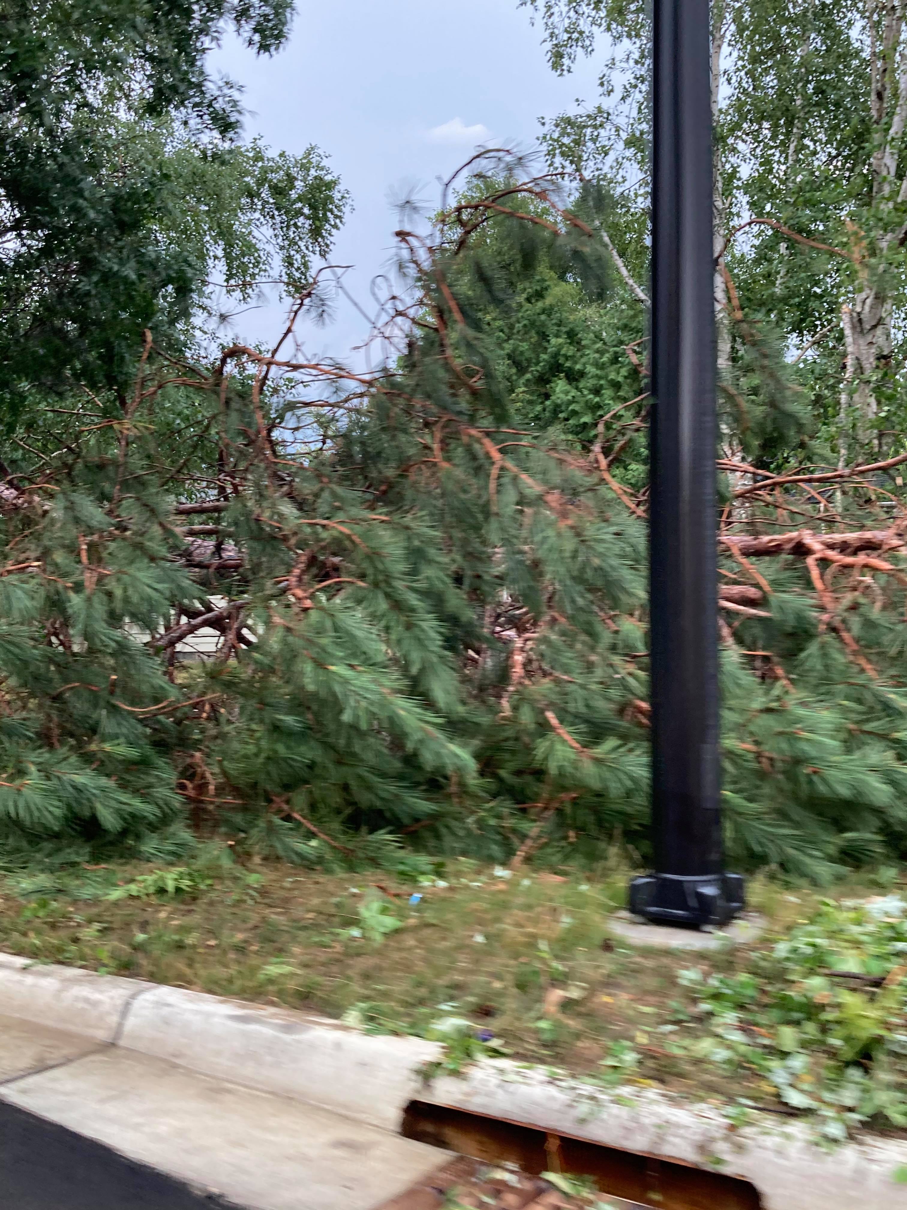
| Tree damage in Grand Rapids (Ryan Jensen photo) |
Tree damage in Grand Rapids (Ryan Jensen photo) |
Tree damage in Grand Rapids (Kelly Holmied photo) |
Tree damage in Grand Rapids (Trena Erickson Badilla photo) |
 |
 |
 |
 |
| Tree damage in Two Harbors (Angela Thompson-Yost photo) |
Tree damage in Two Harbors (Christina Cavallin photo) |
Tree damage in Two Harbors (Michelle Fischer Rogers photo) |
Tree and home damage in Drummond, WI (Troy Swanson photo) |
 |
 |
 |
 |
| Tree damage near Gordon, WI (Shanna Lee photo) |
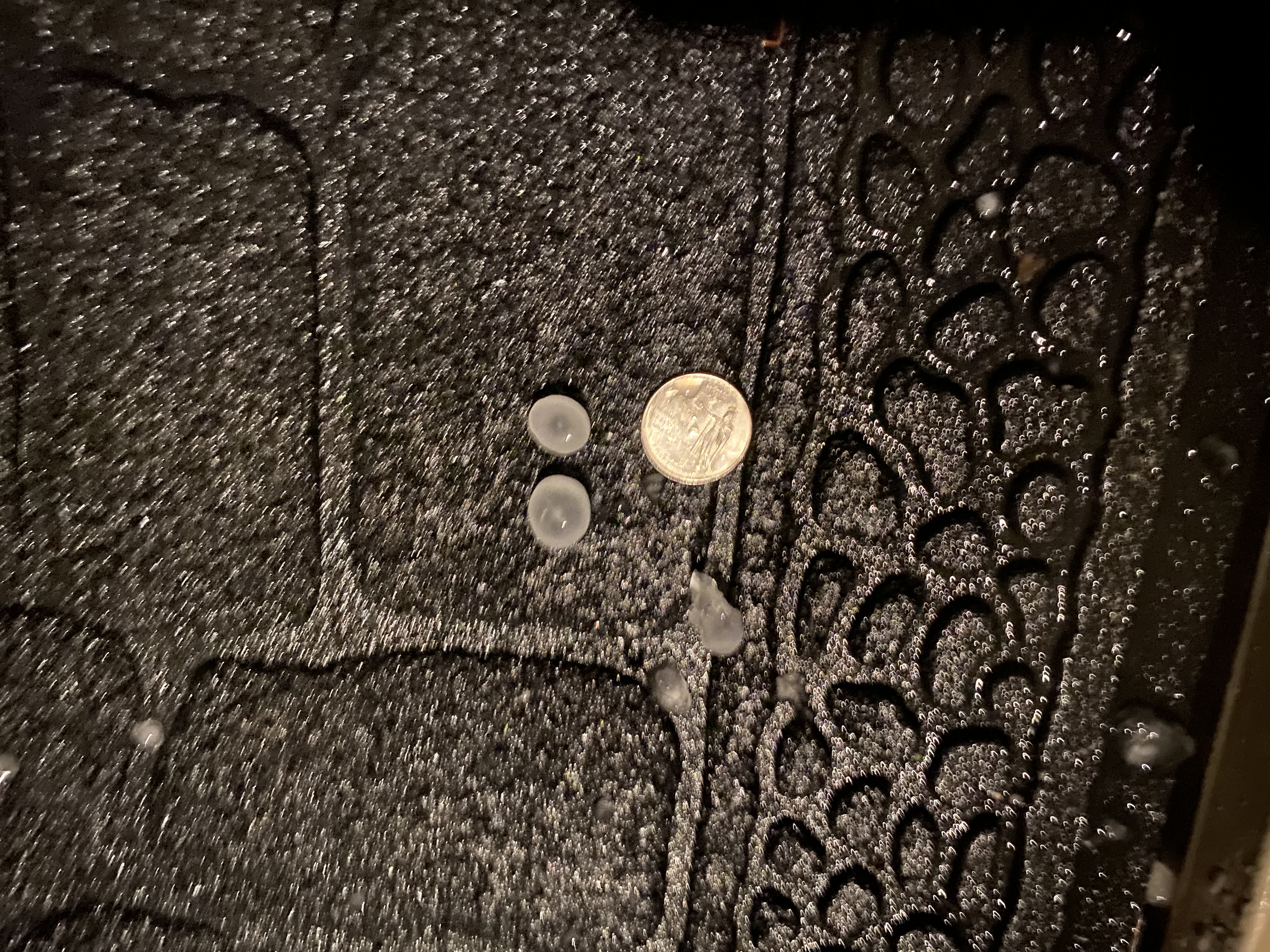
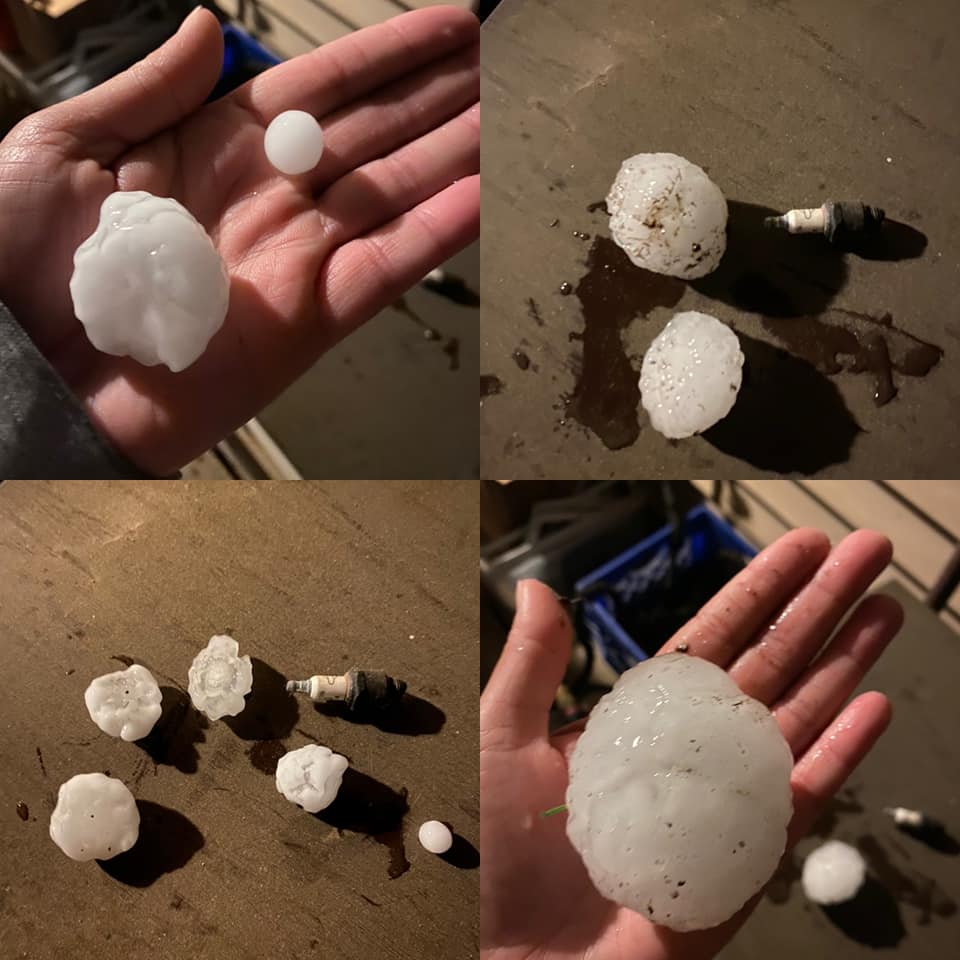
2.9" hail in Bena, MN (Lindsay Rooney photo) |
0.8" hail in Duluth (Beth Colyear photo) |
2"+ hail in Superior East End (Autumn Perrin photo) |
 |
 |
||
| 3" hail near Poplar, WI (Krista Ault photo) |
3" hail near Maple, WI (Becky Landwehr photo) |
A short video of a wall cloud near Bena, Minnesota. The video was taken in Federal Dam looking northward towards US2/Bena at 6:30PM. This storm had earlier produced a tornado near Red Lake in Beltrami County.
(Video courtesy of Sara Rose)
Radar
Coming soon.
Storm Reports
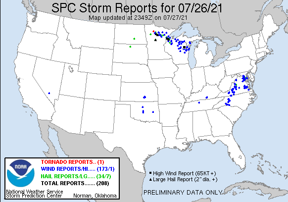
Click the image above for Storm Reports from around the country.
PRELIMINARY LOCAL STORM REPORT...SUMMARY
NATIONAL WEATHER SERVICE DULUTH MN
436 PM CDT TUE JUL 27 2021

..TIME...   ...EVENT...      ...CITY LOCATION...     ...LAT.LON...
..DATE...   ....MAG....      ..COUNTY LOCATION..ST.. ...SOURCE....
            ..REMARKS..

0600 PM     TSTM WND DMG     WIRT                    47.73N 93.96W
07/26/2021                   ITASCA             MN   PUBLIC

            A PHOTO WAS RECEIVED OF A SNAPPED POWER POLE
            IN WIRT. TIME ESTIMATED BY RADAR.

0612 PM     TSTM WND DMG     SIDE LAKE               47.67N 93.02W
07/26/2021                   ST. LOUIS          MN   PUBLIC

            PHOTOS RECEIVED OF TREE AND DOCK DAMAGE
            AROUND SIDE LAKE. TIME ESTIMATED FROM RADAR.

0615 PM     HAIL             5 NE SCHLEY             47.41N 94.34W
07/26/2021  E1.50 INCH       CASS               MN   PUBLIC

            ESTIMATE AT LEAST PING-PONG BALL SIZE HAIL
            PER VIDEOS POSTED ON SNAPCHAT. TIME AND
            LOCATION ESTIMATED.

0617 PM     TSTM WND DMG     1 SSE JESSIE LAKE       47.59N 93.81W
07/26/2021                   ITASCA             MN   PUBLIC

            PHOTOS AND VIDEO RECEIVED OF DAMAGE ALONG
            THE SHORE OF JESSIE LAKE. A DOCK WAS
            OVERTURNED ALONG WITH A BOAT LIFT. THE
            PONTOON BOAT ON THE LIFT WAS ALSO
            OVERTURNED.

0634 PM     HAIL             BENA                    47.34N 94.21W
07/26/2021  M3.00 INCH       CASS               MN   PUBLIC

            HAIL UP TO 2.9 INCHES MEASURED NEAR BENA.
            PHOTO AND REPORT VIA TWITTER. TIME ESTIMATED
            FROM RADAR.

0647 PM     HAIL             5 NE DEER RIVER         47.40N 93.72W
07/26/2021  M0.70 INCH       ITASCA             MN   TRAINED SPOTTER

            DIME SIZE HAIL AND GUSTY WINDS.

0650 PM     TSTM WND DMG     3 NW SKIBO              47.52N 92.05W
07/26/2021                   ST. LOUIS          MN   911 CALL CENTER

            TREE DOWN IN BASSETT TOWNSHIP.

0650 PM     TSTM WND DMG     DEER RIVER              47.33N 93.79W
07/26/2021                   ITASCA             MN   PUBLIC

            A FEW TREES WERE REPORTED DOWN IN DEER
            RIVER. TIME ESTIMATED BY RADAR.

0655 PM     TSTM WND DMG     COHASSET                47.26N 93.63W
07/26/2021                   ITASCA             MN   PUBLIC

            LARGE PINE TREE UPROOTED. REPORT VIA SOCIAL
            MEDIA. TIME ESTIMATED FROM RADAR.

0700 PM     TSTM WND DMG     1 WNW ZIM               47.31N 92.63W
07/26/2021                   ST. LOUIS          MN   TRAINED SPOTTER

            16 INCH TREE UPROOTED.

0705 PM     HAIL             3 E LA PRAIRIE          47.24N 93.42W
07/26/2021  M1.75 INCH       ITASCA             MN   PUBLIC

            SEVERAL GOLF BALL-SIZED HAIL BUT MOSTLY
            QUARTER-SIZED HAIL. TIME ESTIMATED BY RADAR.

0706 PM     HAIL             3 NE LA PRAIRIE         47.26N 93.45W
07/26/2021  U1.00 INCH       ITASCA             MN   PUBLIC

            REPORT FROM MPING: QUARTER (1.00 IN.).

0708 PM     TSTM WND DMG     GRAND RAPIDS            47.23N 93.52W
07/26/2021                   ITASCA             MN   TRAINED SPOTTER

            BIG BRANCHES OFF TREES AND A FLAG POLE
            SNAPPED IN HALF DUE TO DAMAGING WINDS.
            LOCATION APPROXIMATE.

0712 PM     TSTM WND GST     1 SSE GRAND RAPIDS      47.22N 93.52W
07/26/2021  M54 MPH          ITASCA             MN   AWOS

            AWOS STATION KGPZ GRAND RAPIDS AIRPORT.

0713 PM     HAIL             3 S BOVEY               47.24N 93.40W
07/26/2021  M1.00 INCH       ITASCA             MN   COCORAHS

            MN-IT-39.

0714 PM     HAIL             2 SSW COLERAINE         47.28N 93.44W
07/26/2021  U1.00 INCH       ITASCA             MN   PUBLIC

            REPORT FROM MPING: QUARTER (1.00 IN.).

0716 PM     HAIL             1 WSW BLACKBERRY        47.17N 93.42W
07/26/2021  U1.00 INCH       ITASCA             MN   PUBLIC

            REPORT FROM MPING: QUARTER (1.00 IN.).

0720 PM     HAIL             BLACKBERRY              47.18N 93.39W
07/26/2021  M1.00 INCH       ITASCA             MN   TRAINED SPOTTER

            HAIL STILL FALLING AT TIME OF REPORT.
            LOCATION APPROXIMATE.

0720 PM     HAIL             2 WSW BOVEY             47.28N 93.43W
07/26/2021  E0.88 INCH       ITASCA             MN   PUBLIC

            A FEW BRANCHES DOWN AS WELL.

0728 PM     TSTM WND DMG     GRAND RAPIDS            47.23N 93.52W
07/26/2021                   ITASCA             MN   TRAINED SPOTTER

            LOCATION APPROXIMATE. MARBLE SIZE HAIL,
            APPROXIMATELY 9 80 FOOT TALL NORWAY PINE
            TREES UPROOTED.

0735 PM     TSTM WND GST     4 W TWO HARBORS         47.03N 91.75W
07/26/2021  M41 MPH          LAKE               MN   AWOS

            AWOS STATION KTWM TWO HARBORS AIRPORT.

0736 PM     TSTM WND DMG     1 SSE TWO HARBORS       47.02N 91.67W
07/26/2021                   LAKE               MN   TRAINED SPOTTER

            TOP PART OF A HEALTHY PINE TREE KNOCKED
            OVER, PUNCTURING GARAGE ROOF.

0740 PM     TSTM WND DMG     JACOBSON                47.00N 93.26W
07/26/2021                   AITKIN             MN   911 CALL CENTER

            TREES DOWN IN JACOBSON. FIRE DEPT ALSO
            DISPATCHED TO POWERLINE DOWN. TIME RADAR
            ESTIMATED.

0751 PM     HAIL             2 ENE CULVER            46.94N 92.52W
07/26/2021  M0.75 INCH       ST. LOUIS          MN   TRAINED SPOTTER

            PENNY SIZE HAIL AND GUSTY WINDS BUT NO
            DAMAGE ASIDE FROM SOME LEAVES BLOWN OFF
            TREES.

0758 PM     TSTM WND GST     DULUTH INTERNATIONAL AI 46.85N 92.20W
07/26/2021  M46 MPH          ST. LOUIS          MN   ASOS

            ASOS STATION KDLH DULUTH INTERNATIONAL
            AIRPORT.

0801 PM     HAIL             4 NNW HERMANTOWN        46.85N 92.28W
07/26/2021  U0.75 INCH       ST. LOUIS          MN   PUBLIC

            REPORT FROM MPING: DIME (0.75 IN.).

0802 PM     HAIL             1 WSW SAGINAW           46.85N 92.46W
07/26/2021  M0.88 INCH       ST. LOUIS          MN   TRAINED SPOTTER

            HAIL AND GUSTY WINDS.

0806 PM     HAIL             NWS DULUTH              46.84N 92.21W
07/26/2021  M0.50 INCH       ST. LOUIS          MN   OFFICIAL NWS OBS


0808 PM     TSTM WND GST     1 SSE DULUTH            46.77N 92.11W
07/26/2021  M42 MPH          ST. LOUIS          MN   MESONET

            MESONET STATION MN082 DULUTH I-35 AND
            GARFIELD.

0810 PM     HAIL             2 NNE DULUTH            46.81N 92.11W
07/26/2021  E1.00 INCH       ST. LOUIS          MN   AMATEUR RADIO

            MAINLY PEA TO DIME SIZE HAIL. A FEW QUARTER
            SIZE HAILSTONES. TIME ESTIMATED BY SPOTTER.

0810 PM     MARINE TSTM WIND 7 SSE FRENCH RIVER      46.81N 91.83W
07/26/2021  M40 MPH          LSZ162             MN   MESONET

            UMD OFFSHORE BUOY 45028 6 SE FRENCH RIVER.

0810 PM     TSTM WND DMG     2 WSW LESTER PARK       46.83N 92.07W
07/26/2021                   ST. LOUIS          MN   PUBLIC

            LARGE PORTION OF A 50-60 FOOT TREE BROKE
            OFF, TAKING OUT POWER LINE.

0811 PM     HAIL             4 NE HERMANTOWN         46.84N 92.18W
07/26/2021  U1.00 INCH       ST. LOUIS          MN   PUBLIC

            REPORT FROM MPING: QUARTER (1.00 IN.).

0811 PM     TSTM WND GST     2 NNW SUPERIOR          46.75N 92.10W
07/26/2021  M62 MPH          LSZ145             WI   MESONET

            MESONET STATION MN081 BLATNIK BRIDGE.

0812 PM     MARINE TSTM WIND 1 NNW SUPERIOR          46.73N 92.10W
07/26/2021  M39 MPH          DOUGLAS            WI   MESONET

            MESONET STATION MN095 BLATNIK BRIDGE SOUTH.

0815 PM     MARINE TSTM WIND 6 SE DULUTH             46.72N 92.03W
07/26/2021  M43 MPH          ST. LOUIS          MN   AWOS

            AWOS STATION KDYT DULUTH SKY HARBOR AIRPORT.

0815 PM     TSTM WND DMG     3 NE DULUTH             46.81N 92.08W
07/26/2021                   ST. LOUIS          MN   NWS EMPLOYEE

            HALF OF A TREE FALLEN OVER A HOUSE. NICKEL
            SIZE HAIL. TIME APPROXIMATE.

0818 PM     MARINE TSTM WIND 1 ESE DULUTH            46.78N 92.09W
07/26/2021  M51 MPH          ST. LOUIS          MN   MESONET

            STATION DULM5 DULUTH HARBOR.

0826 PM     TSTM WND DMG     SUPERIOR                46.72N 92.09W
07/26/2021                   DOUGLAS            WI   PUBLIC

            MULTIPLE REPORTS RECEIVED OF TREES DOWN
            AROUND SUPERIOR.

0846 PM     MARINE TSTM WIND 5 ENE WASHBURN          46.70N 90.80W
07/26/2021  M43 MPH          LSZ121             WI   MESONET

            MESONET STATION DW6222 LA POINTE.

0855 PM     MARINE TSTM WIND 1 E LA POINTE           46.78N 90.77W
07/26/2021  M41 MPH          ASHLAND            WI   AWOS

            AWOS STATION K4R5 LA POINTE AIRPORT.

0903 PM     MARINE TSTM WIND 5 ENE WASHBURN          46.70N 90.80W
07/26/2021  M48 MPH          LSZ121             WI   MESONET

            UPDATE PREVIOUS REPORT, MAX WIND FROM THIS
            LINE OF STORMS. MESONET STATION DW6222 LA
            POINTE.

0903 PM     TSTM WND DMG     GORDON                  46.25N 91.80W
07/26/2021                   DOUGLAS            WI   PUBLIC

            A PHOTO WAS RECEIVED OF A DOWNED TREE IN
            GORDON.

0912 PM     HAIL             4 SE SILICA             47.23N 92.95W
07/26/2021  M1.00 INCH       ST. LOUIS          MN   TRAINED SPOTTER

            12 MILES SOUTH OF HIBBING.

0945 PM     TSTM WND GST     2 ENE HAYWARD           46.02N 91.45W
07/26/2021  M48 MPH          SAWYER             WI   ASOS

            ASOS STATION KHYR HAYWARD AIRPORT.

0953 PM     TSTM WND GST     3 SW ASHLAND            46.55N 90.92W
07/26/2021  M47 MPH          ASHLAND            WI   ASOS

            ASOS STATION KASX ASHLAND AIRPORT.

1003 PM     TSTM WND DMG     MERCER                  46.17N 90.06W
07/26/2021                   IRON               WI   FIRE DEPT/RESCUE

            MULTIPLE TREES DOWN IN TOWN OF MERCER. FIRE
            DEPT DISPATCHED TO SEVERAL LOCATIONS ACROSS
            TOWN.

1057 PM     HAIL             5 SE SUPERIOR           46.68N 92.01W
07/26/2021  M1.75 INCH       DOUGLAS            WI   PUBLIC


1100 PM     HAIL             1 WSW MAPLE             46.59N 91.75W
07/26/2021  M2.50 INCH       DOUGLAS            WI   COCORAHS


1100 PM     HAIL             1 ESE POPLAR            46.58N 91.77W
07/26/2021  M3.00 INCH       DOUGLAS            WI   PUBLIC

            SEVERAL 2 TO 3 INCH HAIL STONES. TIME
            ESTIMATED.

1100 PM     HAIL             SUPERIOR                46.72N 92.09W
07/26/2021  M2.00 INCH       DOUGLAS            WI   TRAINED SPOTTER


1100 PM     HAIL             POPLAR                  46.59N 94.70W
07/26/2021  M3.00 INCH       CASS               MN   TRAINED SPOTTER

            CORRECTS: ERRONEOUS REPORT PLEASE DISREGARD.

1110 PM     HAIL             3 NNW POPLAR            46.63N 91.83W
07/26/2021  M1.50 INCH       DOUGLAS            WI   TRAINED SPOTTER

            SPOTTER REPORTED 1 AND 9 SIXTEENTHS INCH
            DIAMETER HAIL APPROXIMATELY 1110 PM.

1120 PM     HAIL             2 ESE POPLAR            46.58N 91.75W
07/26/2021  E3.00 INCH       DOUGLAS            WI   PUBLIC

            PHOTOS OF NUMEROUS LARGE HAILSTONES - BIGGER
            THAN A GOLF BALL IN THE PHOTO.

1130 PM     HAIL             BRULE                   46.55N 91.58W
07/26/2021  E1.00 INCH       DOUGLAS            WI   PUBLIC


1138 PM     HAIL             MAPLE                   46.59N 91.72W
07/26/2021  E1.00 INCH       DOUGLAS            WI   TRAINED SPOTTER


1155 PM     HAIL             4 NW NAMEKAGON          46.26N 91.10W
07/26/2021  M1.00 INCH       BAYFIELD           WI   TRAINED SPOTTER


1200 AM     TSTM WND DMG     3 WNW NAMEKAGON         46.23N 91.10W
07/27/2021                   BAYFIELD           WI   TRAINED SPOTTER

            8 INCH TREE DOWN.

1206 AM     TSTM WND DMG     PORT WING               46.78N 91.39W
07/27/2021                   BAYFIELD           WI   PUBLIC

            MULTIPLE TREES REPORTED DOWN IN PORT WING.
            TIME ESTIMATED BY RADAR.

1230 AM     TSTM WND DMG     4 NW NAMEKAGON          46.25N 91.11W
07/27/2021                   BAYFIELD           WI   TRAINED SPOTTER

            TREES DOWN ON POWERLINES CAUSING POWER
            OUTAGE. TREE SIZE NOT KNOWN AT THIS TIME.

1234 AM     HAIL             3 WNW CLAM LAKE         46.17N 90.98W
07/27/2021  M0.50 INCH       BAYFIELD           WI   CO-OP OBSERVER

            HAIL FELL BETWEEN 0034HRS TO 0040HRS.

1245 AM     HAIL             2 WSW NAMEKAGON         46.20N 91.08W
07/27/2021  M0.50 INCH       BAYFIELD           WI   TRAINED SPOTTER

            TIME ESTIMATED.

0109 AM     HAIL             HAYWARD                 46.01N 91.48W
07/27/2021  M1.25 INCH       SAWYER             WI   TRAINED SPOTTER

            HALF DOLLAR SIZED HAIL REPORTED IN HAYWARD.

0131 AM     TSTM WND DMG     6 N WINTER              45.90N 91.03W
07/27/2021                   SAWYER             WI   TRAINED SPOTTER

            A FEW SMALLER TREES DOWN AND THE TOP OF A
            BIGGER TREE DOWN DUE TO DAMAGING WINDS.

0140 AM     TSTM WND DMG     RADISSON                45.77N 91.22W
07/27/2021                   SAWYER             WI   TRAINED SPOTTER

            MULTIPLE PINE TREES UPROOTED.

0533 AM     HAIL             1 W WEBB LAKE           46.01N 92.16W
07/27/2021  E0.50 INCH       BURNETT            WI   TRAINED SPOTTER

            PEA SIZE HAIL STARTED ABOUT TEN MINUTES
            PRIOR TO REPORT. HALF-INCH DIAMETER HAIL AT
            TIME WITH HEAVY RAINFALL.


&&

$$
Rain Reports
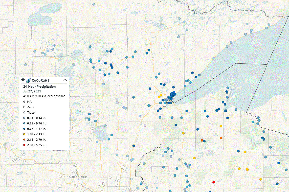
An overview (above) of the CoCoRaHS reports ending at 9:30AM July 27, 2021. This does not include ASOS/AWOS or COOP reports.
PUBLIC INFORMATION STATEMENT
NATIONAL WEATHER SERVICE DULUTH MN
1004 AM CDT TUE JUL 27 2021

...24 HOUR RAINFALL REPORTS ENDING TUESDAY JULY 27 MORNING...

LOCATION                     AMOUNT    TIME/DATE       PROVIDER

...MINNESOTA...

...AITKIN COUNTY...
AITKIN 7.6 SSW               0.42 IN   0800 AM 07/27   COCORAHS
ISLE 5.6 NNE                 0.18 IN   0700 AM 07/27   COCORAHS
12 N ISLE                    0.17 IN   0700 AM 07/27   COOP
AITKIN 13.9 SSE              0.08 IN   0700 AM 07/27   COCORAHS
HILL CITY RAWS               0.02 IN   0907 AM 07/27   RAWS


...CARLTON COUNTY...
WRENSHALL 2.3 S              0.80 IN   0700 AM 07/27   COCORAHS
WRENSHALL 2.6 E              0.78 IN   0700 AM 07/27   COCORAHS
WRENSHALL                    0.75 IN   0800 AM 07/27   UCOOP
1.5 S PLEASANT VALLEY        0.56 IN   0945 AM 07/27   HADS
WRENSHALL 9.7 SSE            0.54 IN   0700 AM 07/27   COCORAHS
CARLTON 5.6 NE               0.50 IN   0900 AM 07/27   COCORAHS
CLOQUET 5.7 SW               0.49 IN   0700 AM 07/27   COCORAHS
CLOQUET 5.9 SW               0.47 IN   0700 AM 07/27   COCORAHS
3 E WRIGHT                   0.44 IN   0600 AM 07/27   COOP
ESKO                         0.31 IN   0955 AM 07/27   CWOP
BARNUM 4.3 W                 0.05 IN   0600 AM 07/27   COCORAHS

...CASS COUNTY...
CASS LAKE DNR RAWS           0.85 IN   0901 AM 07/27   RAWS
CASS LAKE                    0.85 IN   0800 AM 07/27   COOP
CHIPPEWA PORT NO. 5          0.35 IN   0915 AM 07/27   RAWS
2.3 SE BALL CLUB             0.08 IN   0915 AM 07/27   HADS
5.9 N BREVIK                 0.01 IN   0930 AM 07/27   USGS
CASS LAKE US-2 MP 131         T IN     0950 AM 07/27   MNDOT

...COOK COUNTY...
SCHROEDER                    0.09 IN   0950 AM 07/27   CWOP
SEAGULL LAKE RAWS            0.09 IN   0904 AM 07/27   RAWS
SUPERIOR QD NO. 4            0.08 IN   0942 AM 07/27   RAWS
GRAND MARAIS 4.4 WSW         0.07 IN   0700 AM 07/27   COCORAHS
GRAND PORTAGE                0.06 IN   0946 AM 07/27   CWOP
GRAND MARAIS 21.7 ENE        0.06 IN   0800 AM 07/27   COCORAHS
GRAND MARAIS 4.4 W           0.06 IN   0600 AM 07/27   COCORAHS
GRAND MARAIS                 0.05 IN   0958 AM 07/27   CWOP
GRAND MARAIS 3.8 NNE         0.05 IN   0700 AM 07/27   COCORAHS
GRAND PORTAGE RAWS           0.04 IN   0944 AM 07/27   RAWS
GRAND MARAIS 10.1 NNW        0.04 IN   0800 AM 07/27   COCORAHS
TOFTE 4.9 NE                 0.04 IN   0700 AM 07/27   COCORAHS
HOVLAND 0.1 NE               0.04 IN   0700 AM 07/27   COCORAHS
BRULE RIVER NR HOVLAND       0.01 IN   0945 AM 07/27   HADS
LUTSEN                       0.01 IN   0845 AM 07/27   HADS
GRAND PORTAGE RWIS            T IN     0950 AM 07/27   MNDOT

...CROW WING COUNTY...
AITKIN 9.6 W                 0.21 IN   0800 AM 07/27   COCORAHS
CROSBY 1.1 SW                0.07 IN   0700 AM 07/27   COCORAHS
TROMMALD 6.1 NW               T IN     0800 AM 07/27   COCORAHS

...ITASCA COUNTY...
GRAND RAPIDS 6.1 N           1.26 IN   0700 AM 07/27   COCORAHS
COLERAINE 0.7 S              1.24 IN   0700 AM 07/27   COCORAHS
COLERAINE 1.5 S              1.12 IN   0700 AM 07/27   COCORAHS
BOVEY 3.5 S                  0.93 IN   0700 AM 07/27   COCORAHS
3.8 S SWAN RIVER             0.92 IN   0945 AM 07/27   HADS
WARBA 2.2 NNW                0.83 IN   0700 AM 07/27   COCORAHS
DEER RIVER                   0.81 IN   0945 AM 07/27   CWOP
BOVEY 13.4 N                 0.77 IN   0649 AM 07/27   COCORAHS
COHASSET 7.6 NNW             0.72 IN   0700 AM 07/27   COCORAHS
BOVEY 14.4 NNW               0.65 IN   0800 AM 07/27   COCORAHS
BOVEY 15.9 N                 0.62 IN   0600 AM 07/27   COCORAHS
GRAND RAPIDS 6.1 SSE         0.62 IN   0800 AM 07/27   COCORAHS
GRAND RAPIDS 12 N            0.60 IN   0630 AM 07/27   COOP
KEEWATIN 0.2 SSE             0.35 IN   0800 AM 07/27   COCORAHS
EFFIE RAWS                   0.28 IN   0907 AM 07/27   RAWS
DEER RIVER 3.7 W             0.26 IN   0800 AM 07/27   COCORAHS
CUTFOOT RAWS                 0.21 IN   0904 AM 07/27   RAWS
DEER RIVER 4.4 WNW           0.17 IN   0800 AM 07/27   COCORAHS
GRAND RAPIDS AIRPORT         0.02 IN   0956 AM 07/27   AWOS
4.6 N TACONITE               0.01 IN   0945 AM 07/27   HADS
EFFIE MN-1 MILE POST 194      T IN     0645 AM 07/27   MNDOT

...KOOCHICHING COUNTY...
LITTLEFORK                   0.23 IN   0930 AM 07/27   HADS
BIG FALLS 1.0 N              0.08 IN   0730 AM 07/27   COCORAHS
INTERNATIONAL FALLS 10.3 E   0.08 IN   0800 AM 07/27   COCORAHS
LITTLEFORK RAWS              0.07 IN   0908 AM 07/27   RAWS
INTERNATIONAL FALLS 0.6 NW   0.01 IN   0730 AM 07/27   COCORAHS
INTERNATIONAL FALLS AIRPORT   T IN     0954 AM 07/27   ASOS
MARGIE US-71 MP 379           T IN     0910 AM 07/27   MNDOT
INDUS                         T IN     0800 AM 07/27   COOP

...LAKE COUNTY...
TWO HARBORS 9.7 NNE          0.79 IN   0700 AM 07/27   COCORAHS
TWO HARBORS 3.6 WNW          0.72 IN   0700 AM 07/27   COCORAHS
TWO HARBORS 12.3 NE          0.64 IN   0700 AM 07/27   COCORAHS
KNIFE RIVER 1.2 N            0.55 IN   0700 AM 07/27   COCORAHS
TWO HARBORS 2.1 NW           0.52 IN   0700 AM 07/27   COCORAHS
TWO HARBORS                  0.46 IN   0700 AM 07/27   COOP
BEAVER R NR BEAVER BAY       0.25 IN   0945 AM 07/27   HADS
SILVER BAY                   0.13 IN   0700 AM 07/27   UCOOP
ISABELLA RAWS                0.09 IN   0904 AM 07/27   RAWS
8.4 E BABBITT                0.09 IN   0930 AM 07/27   HADS
ELY 8.1 SE                   0.06 IN   0700 AM 07/27   COCORAHS
WOLF RIDGE                   0.05 IN   0700 AM 07/27   COOP
SUPERIOR QD NO. 1            0.04 IN   0939 AM 07/27   RAWS
7.9 SE WINTON                0.03 IN   0930 AM 07/27   HADS
FERNBERG RAWS                0.02 IN   0913 AM 07/27   RAWS
ELY 25 E                     0.01 IN   0656 AM 07/27   COOP
SILVER CLIFF MN-61 MILE POST  T IN     0722 AM 07/27   MNDOT

...PINE COUNTY...
AUDUBON CENTER SANDSTONE 6 W 1.98 IN   0915 AM 07/27   HADS
HINCKLEY 2.4 N               1.01 IN   0700 AM 07/27   COCORAHS
ST. CROIX RAWS               0.56 IN   0915 AM 07/27   RAWS
PINE CITY 1.8 ENE            0.10 IN   0700 AM 07/27   COCORAHS
BROOK PARK 3.9 S             0.06 IN   0700 AM 07/27   COCORAHS
PINE CITY 0.7 SSW            0.04 IN   0700 AM 07/27   COCORAHS
HINCKLEY I-35 MILE POST 181   T IN     0950 AM 07/27   MNDOT
STURGEON LAKE 7.5 ESE         T IN     0600 AM 07/27   COCORAHS

...ST. LOUIS COUNTY...
DULUTH 10.4 WNW              1.64 IN   0700 AM 07/27   COCORAHS
CLOQUET 8.2 NE               1.50 IN   0600 AM 07/27   COCORAHS
DULUTH 1.2 SE                1.41 IN   0500 AM 07/27   COCORAHS
DULUTH                       1.41 IN   0600 AM 07/27   COCORAHS
CLOQUET RIVER NR BURNETT     1.40 IN   0915 AM 07/27   HADS
DULUTH 7.4 NNE               1.24 IN   0700 AM 07/27   COCORAHS
DULUTH 2.2 WNW               1.23 IN   0700 AM 07/27   COCORAHS
DULUTH 4.6 NE                1.20 IN   0800 AM 07/27   COCORAHS
DULUTH 6.2 NE                1.19 IN   0700 AM 07/27   COCORAHS
AURORA                       1.16 IN   0955 AM 07/27   CWOP
SAGINAW RAWS                 1.15 IN   0908 AM 07/27   RAWS
DULUTH 1.9 NNE               1.14 IN   0700 AM 07/27   COCORAHS
DULUTH 4.2 NNE               1.12 IN   0800 AM 07/27   COCORAHS
DULUTH 6.3 NE                1.12 IN   0900 AM 07/27   COCORAHS
NWS DULUTH                   1.11 IN   0700 AM 07/27   COOP
DULUTH 6.9 NNE               1.08 IN   0700 AM 07/27   COCORAHS
CULVER 0.2 W                 1.07 IN   0700 AM 07/27   COCORAHS
DULUTH INTERNATIONAL AIRPORT 1.05 IN   0955 AM 07/27   ASOS
DULUTH 17.6 NNW              1.04 IN   0630 AM 07/27   COCORAHS
DULUTH 7.9 WSW               1.00 IN   0700 AM 07/27   COCORAHS
DULUTH 4.1 NNE               0.99 IN   0600 AM 07/27   COCORAHS
DULUTH 3.6 NE                0.98 IN   0700 AM 07/27   COCORAHS
CLOQUET RIVER NR BRIMSON     0.97 IN   0945 AM 07/27   HADS
DULUTH 6.0 NE                0.95 IN   0700 AM 07/27   COCORAHS
DULUTH 11.8 NNE              0.94 IN   0730 AM 07/27   COCORAHS
IRON JUNCTION 3.4 NNW        0.94 IN   0530 AM 07/27   COCORAHS
DULUTH 15.4 NNW              0.94 IN   0700 AM 07/27   COCORAHS
DULUTH 5.6 NE                0.94 IN   0730 AM 07/27   COCORAHS
DULUTH 1.8 NE                0.93 IN   0946 AM 07/27   CWOP
DULUTH 4.3 NE                0.92 IN   0600 AM 07/27   COCORAHS
DULUTH 3.2 NE                0.92 IN   0700 AM 07/27   COCORAHS
DULUTH 3.0 NE                0.90 IN   0730 AM 07/27   COCORAHS
DULUTH 2.7 NE                0.87 IN   0700 AM 07/27   COCORAHS
DULUTH 1.3 N                 0.87 IN   0642 AM 07/27   COCORAHS
DULUTH 5.3 NNE               0.85 IN   0800 AM 07/27   COCORAHS
MOUNTAIN IRON 2.0 ESE        0.84 IN   0700 AM 07/27   COCORAHS
DULUTH 3.9 NE                0.84 IN   0700 AM 07/27   COCORAHS
DULUTH 4.2 NE                0.83 IN   0600 AM 07/27   COCORAHS
SKIBO RAWS                   0.83 IN   0922 AM 07/27   RAWS
CANYON 4.6 NNE               0.75 IN   0700 AM 07/27   COCORAHS
DULUTH 2 NNE                 0.74 IN   1000 AM 07/27   CWOP
DULUTH 5.0 WSW               0.73 IN   0800 AM 07/27   COCORAHS
COLVIN CREEK NR HOYT LAKES   0.68 IN   0945 AM 07/27   HADS
FRENCH RIVER                 0.68 IN   0955 AM 07/27   CWOP
WRIGHT 9.2 NNE               0.65 IN   0700 AM 07/27   COCORAHS
HIBBING 11.6 SSW             0.62 IN   0700 AM 07/27   COCORAHS
3.4 SE LITTLE SWAN           0.60 IN   0945 AM 07/27   HADS
0.5 NW PALMERS               0.59 IN   0845 AM 07/27   HADS
2.1 NW HOYT LAKES            0.53 IN   0915 AM 07/27   HADS
1 NE HIBBING                 0.45 IN   1000 AM 07/27   AWS
DULUTH 7.9 SW                0.44 IN   0900 AM 07/27   COCORAHS
COOK 8NE                     0.38 IN   0600 AM 07/27   COOP
COTTON 5.7 ESE               0.38 IN   0800 AM 07/27   COCORAHS
COTTON                       0.35 IN   0700 AM 07/27   COOP
HIBBING RAWS                 0.35 IN   0907 AM 07/27   RAWS
SUPERIOR QD NO. 2            0.35 IN   0939 AM 07/27   RAWS
HIBBING 0.8 NNE              0.28 IN   0900 AM 07/27   COCORAHS
EVELETH-VIRGINIA AIRPORT     0.25 IN   0955 AM 07/27   AWOS
CHISHOLM-HIBBING AIRPORT     0.23 IN   0953 AM 07/27   ASOS
2.4 S MEADOWLANDS            0.21 IN   0945 AM 07/27   HADS
3.8 E EMBARRASS              0.20 IN   0900 AM 07/27   HADS
CELINA 2 E                   0.19 IN   0900 AM 07/27   COOP
0.5 E FLOODWOOD              0.18 IN   0945 AM 07/27   HADS
EMBARRASS                    0.12 IN   0600 AM 07/27   COOP
3.7 SE CELINA                0.12 IN   0945 AM 07/27   HADS
EMBARRASS                    0.10 IN   0900 AM 07/27   HADS
3.1 SW EMBARRASS             0.09 IN   0900 AM 07/27   HADS
ORR RAWS                     0.09 IN   0908 AM 07/27   RAWS
5.6 S BABBITT                0.09 IN   0900 AM 07/27   HADS
COOK                         0.08 IN   0947 AM 07/27   CWOP
BABBITT 4.4 N                0.06 IN   0700 AM 07/27   COCORAHS
6.0 S BROOKSTON              0.05 IN   0900 AM 07/27   HADS
DUNKA RIVER NR BABBITT       0.04 IN   0900 AM 07/27   HADS
ELY RAWS                     0.04 IN   0904 AM 07/27   RAWS
WINTON 0.1 WSW               0.04 IN   0700 AM 07/27   COCORAHS
1.3 S BUYCK                  0.03 IN   0945 AM 07/27   HADS
4.4 SE BABBITT               0.03 IN   0900 AM 07/27   HADS
KABETOGAMA 1.5 NW            0.03 IN   0700 AM 07/27   COCORAHS
ELY 6.0 NNW                  0.02 IN   0700 AM 07/27   COCORAHS
ANDERSON ROAD RWIS           0.01 IN   0950 AM 07/27   MNDOT
DULUTH I-35 AND GARFIELD      T IN     0953 AM 07/27   MNDOT
COTTON US-53 MP 41            T IN     0950 AM 07/27   MNDOT
THOMPSON HILL I-35 MP 248     T IN     0950 AM 07/27   MNDOT
MITCHELL BRIDGE MN-169 MP 34  T IN     0950 AM 07/27   MNDOT
1 WSW VIRGINIA                T IN     0950 AM 07/27   MNDOT
KABETOGAMA 0.7 SSW            T IN     0700 AM 07/27   COCORAHS

...WISCONSIN...

...ASHLAND COUNTY...
GLIDDEN RAWS                 1.23 IN   0900 AM 07/27   RAWS
ASHLAND 7.2 SSE              0.99 IN   0746 AM 07/27   COCORAHS
ASHLAND 0.5 WNW              0.96 IN   0700 AM 07/27   COCORAHS
ASHLAND AIRPORT              0.85 IN   0953 AM 07/27   ASOS
1 SW ASHLAND                 0.81 IN   0945 AM 07/27   CWOP
ASHLAND 0.6 N                0.64 IN   0800 AM 07/27   COCORAHS
ODANAH 1.6 E                 0.60 IN   0700 AM 07/27   COCORAHS
ODANAH                       0.57 IN   0945 AM 07/27   CWOP
LA POINTE AIRPORT            0.38 IN   0955 AM 07/27   AWOS
1 SE ASHLAND                 0.11 IN   0959 AM 07/27   CWOP

...BAYFIELD COUNTY...
CABLE                        2.36 IN   1000 AM 07/27   CWOP
CLAM LAKE RAWS               2.27 IN   0902 AM 07/27   RAWS
CLAM LAKE 4W                 2.27 IN   0655 AM 07/27   COOP
MELLEN 18.6 SW               2.27 IN   0655 AM 07/27   COCORAHS
MASON 6.9 SSE                1.47 IN   0700 AM 07/27   COCORAHS
BARNES 2.2 S                 1.31 IN   0700 AM 07/27   COCORAHS
WASHBURN RAWS                1.21 IN   0902 AM 07/27   RAWS
IRON RIVER 3.5 ENE           1.20 IN   0522 AM 07/27   COCORAHS
MASON 11.5 WNW               1.07 IN   0800 AM 07/27   COCORAHS
WHITTLESEY CREEK             1.06 IN   0820 AM 07/27   UCOOP
3 NE MOQUAH                  0.99 IN   0600 AM 07/27   COCORAHS
WASHBURN 0.8 N               0.95 IN   0700 AM 07/27   COCORAHS
ASHLAND 9.8 W                0.90 IN   0600 AM 07/27   COCORAHS
BAYFIELD 5.1 NNW             0.85 IN   0700 AM 07/27   COCORAHS
BARNES RAWS                  0.84 IN   0906 AM 07/27   RAWS
WASHBURN 3.7 NW              0.82 IN   0700 AM 07/27   COCORAHS
BAYFIELD 9N                  0.61 IN   0700 AM 07/27   COCORAHS
BAYFIELD 1.7 SW              0.55 IN   0700 AM 07/27   COCORAHS
BAYFIELD FISH HATCHERY       0.51 IN   0800 AM 07/27   COOP
1 W BAYFIELD                 0.10 IN   0958 AM 07/27   CWOP
SAND ISLAND RAWS             0.10 IN   0921 AM 07/27   RAWS

...BURNETT COUNTY...
WEBB LAKE                    0.39 IN   0959 AM 07/27   CWOP
WEBB LAKE 1.1 W              0.36 IN   0700 AM 07/27   COCORAHS
DANBURY                      0.35 IN   0955 AM 07/27   CWOP
SPOONER 13.1 NW              0.31 IN   0800 AM 07/27   COCORAHS
OAKLAND 9.0 ENE              0.19 IN   0700 AM 07/27   COCORAHS
WEBSTER 4.4 ENE              0.09 IN   0800 AM 07/27   COCORAHS
SPOONER 10.6 WNW             0.06 IN   0800 AM 07/27   COCORAHS
GRANTSBURG 0.6 SW (KWIGRANT1 0.05 IN   0701 AM 07/27   COCORAHS
GRANTSBURG 0.6 SSW           0.04 IN   0700 AM 07/27   COCORAHS
LIND RAWS                    0.02 IN   0906 AM 07/27   RAWS

...DOUGLAS COUNTY...
1 WSW GORDON                 1.75 IN   0700 AM 07/27   COCORAHS
POPLAR 2.0 E                 1.35 IN   0700 AM 07/27   COCORAHS
POPLAR                       1.34 IN   0945 AM 07/27   CWOP
SOLON SPRINGS 8.1 W          1.29 IN   0600 AM 07/27   COCORAHS
LAKESIDE                     0.95 IN   0946 AM 07/27   CWOP
SUPERIOR 2.0 WNW             0.92 IN   0530 AM 07/27   COCORAHS
SUPERIOR 4.3 W               0.76 IN   0700 AM 07/27   COCORAHS
SUPERIOR 14.8 S              0.70 IN   0700 AM 07/27   COCORAHS
SUPERIOR AIRPORT             0.68 IN   0955 AM 07/27   AWOS
POPLAR 7.8 SSW               0.61 IN   0700 AM 07/27   COCORAHS
BLATNIK BRIDGE SOUTH          T IN     0958 AM 07/27   MNDOT

...IRON COUNTY...
MERCER 0.4 N                 0.81 IN   0800 AM 07/27   COCORAHS
HURLEY                       0.65 IN   0800 AM 07/27   COOP
PENCE 0.1 E                  0.63 IN   0700 AM 07/27   COCORAHS
HURLEY 4.1 SSE               0.58 IN   0700 AM 07/27   COCORAHS
MERCER 7.0 NNE               0.57 IN   0700 AM 07/27   COCORAHS

...PRICE COUNTY...
PHILLIPS 0.4 SSW             1.95 IN   0700 AM 07/27   COCORAHS
PHILLIPS AIRPORT             1.91 IN   0955 AM 07/27   AWOS
BUTTERNUT 3 SW               1.85 IN   0600 AM 07/27   COOP
PHILLIPS 1.3 S               1.77 IN   0600 AM 07/27   COCORAHS
PHILLIPS 8.6 W               1.58 IN   0800 AM 07/27   COCORAHS
PARK FALLS 1.3 N             1.57 IN   0700 AM 07/27   COCORAHS
BRANTWOOD 2.5 S              1.56 IN   0700 AM 07/27   COCORAHS
BUTTERNUT 5.9 SW             1.40 IN   0630 AM 07/27   COCORAHS
SMITH RAPIDS RAWS            0.92 IN   0947 AM 07/27   RAWS
BRANTWOOD 7.4 S              0.72 IN   0400 AM 07/27   COCORAHS

...SAWYER COUNTY...
HAYWARD AIRPORT              2.76 IN   0953 AM 07/27   ASOS
HAYWARD RAWS                 2.10 IN   0903 AM 07/27   RAWS
HAYWARD 9.7 NE               1.09 IN   0800 AM 07/27   COCORAHS

...WASHBURN COUNTY...
STONE LAKE 2.0 NW            1.97 IN   0700 AM 07/27   COCORAHS
SARONA 6.8 ENE               0.54 IN   0800 AM 07/27   COCORAHS
MINONG RAWS                  0.21 IN   0903 AM 07/27   RAWS
SHELL LAKE 4.3 SW            0.20 IN   0900 AM 07/27   COCORAHS
SARONA 4.5 NNE               0.19 IN   0700 AM 07/27   COCORAHS
SARONA 4.9 E                 0.12 IN   0700 AM 07/27   COCORAHS
SPOONER                      0.08 IN   0700 AM 07/27   COCORAHS

...MARITIME STATIONS...
SUPERIOR 2 ENE               1.62 IN   1158 PM 07/26   COOP
SUPERIOR 3.7 WNW             0.77 IN   0700 AM 07/27   COCORAHS
BAYFIELD                     0.51 IN   0930 AM 07/27   CWOP
2.8 NE OLIVER                0.36 IN   0900 AM 07/27   HADS
LA POINTE                    0.30 IN   0946 AM 07/27   CWOP

OBSERVATIONS ARE COLLECTED FROM A VARIETY OF SOURCES WITH VARYING
EQUIPMENT AND EXPOSURES. WE THANK ALL VOLUNTEER WEATHER OBSERVERS
FOR THEIR DEDICATION. NOT ALL DATA LISTED ARE CONSIDERED OFFICIAL.

$$
Environment
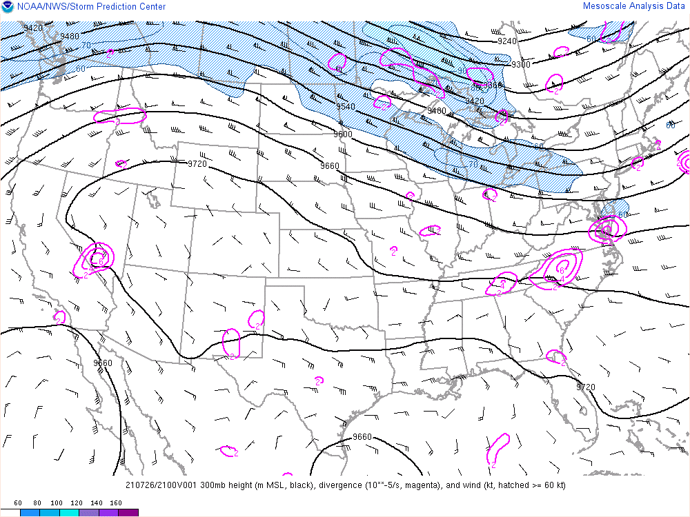
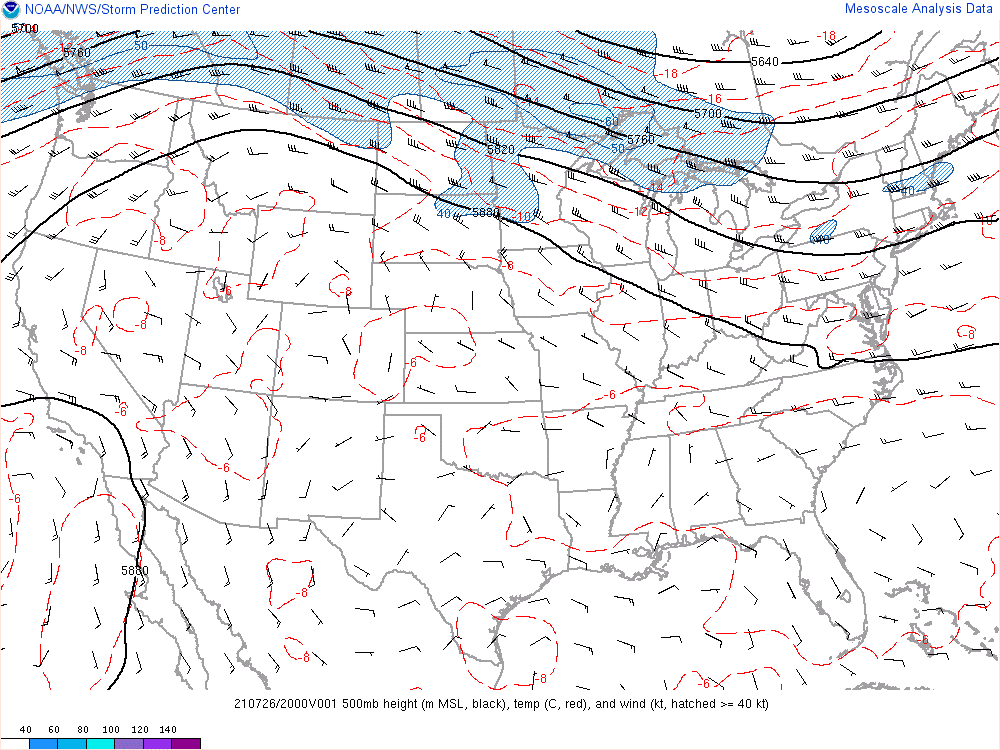
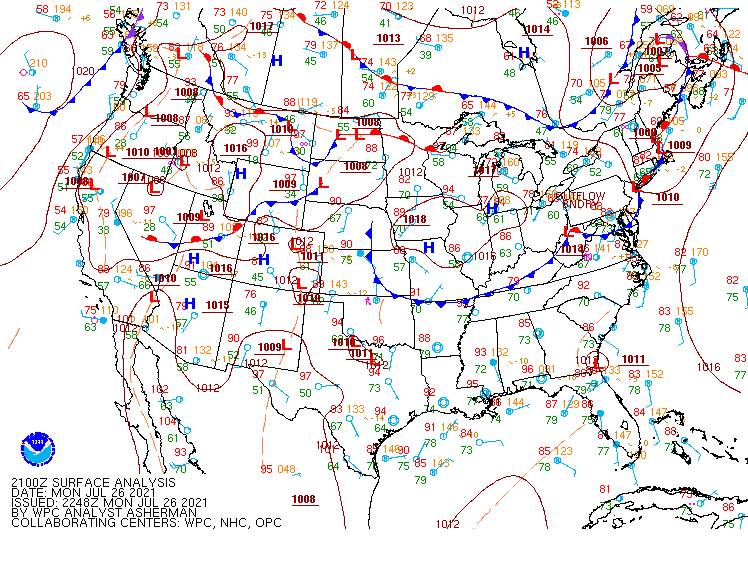
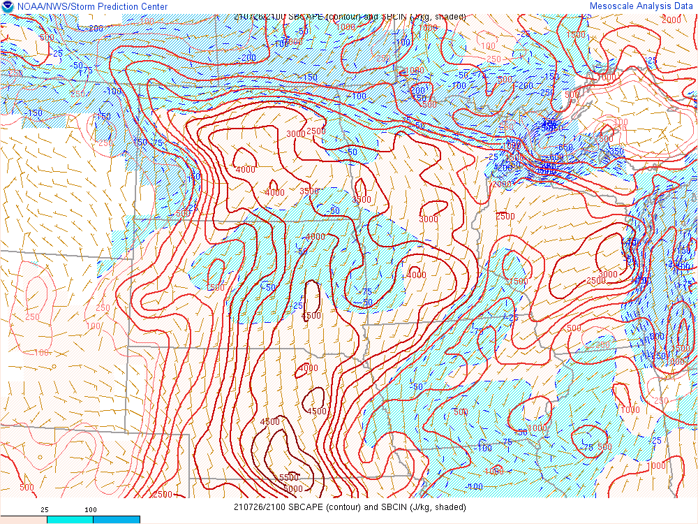
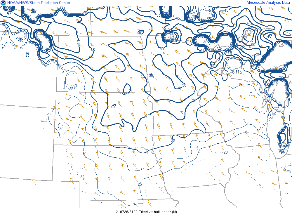
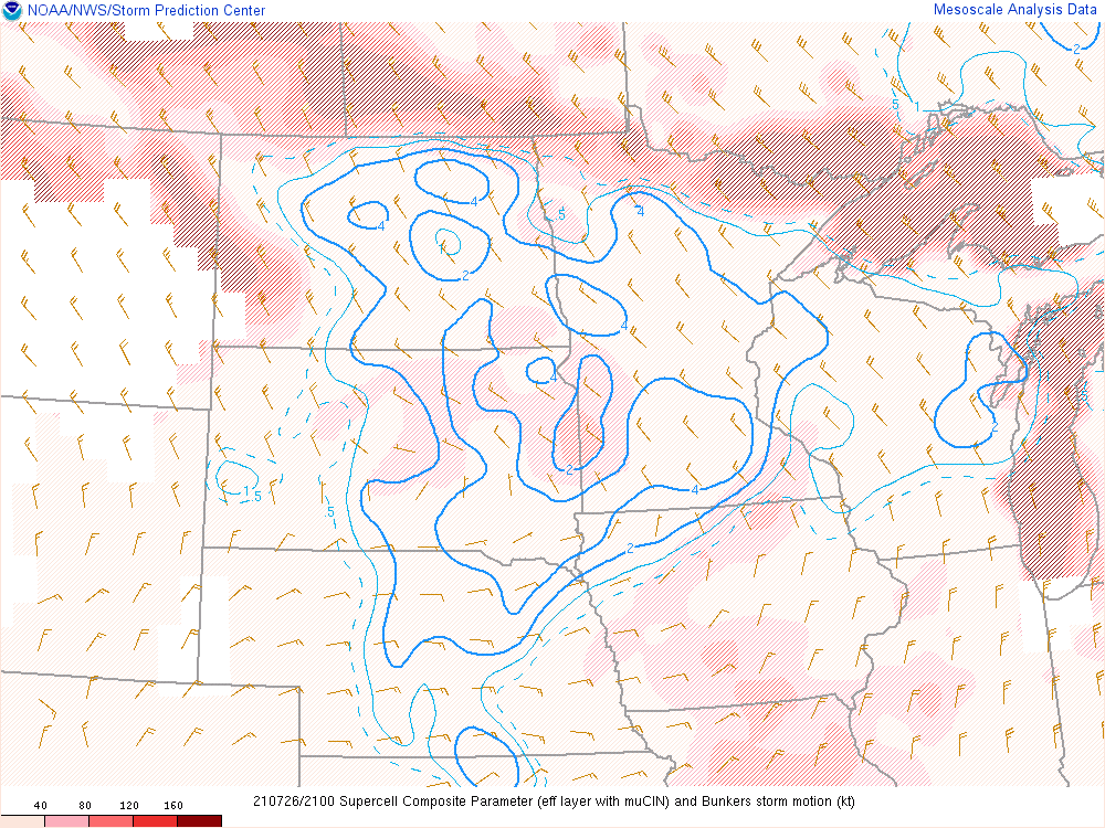
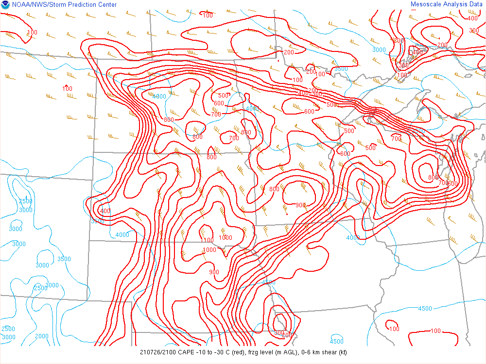
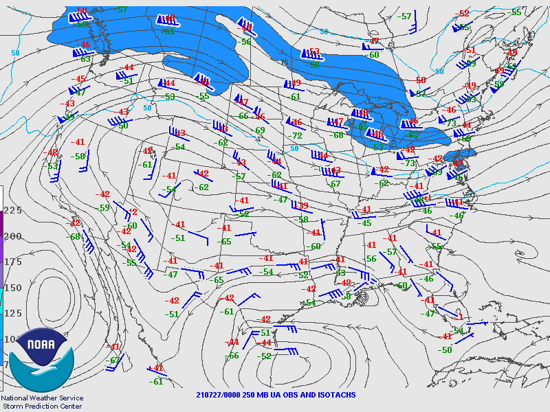
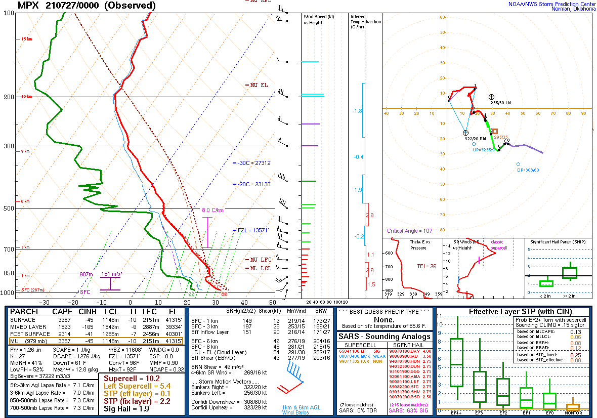
Low pressure was located over central North Dakota during the afternoon hours with a warm front draped east into the Northland, generally from the Brainerd Lakes region east into northwest Wisconsin. Along and south of this boundary, the airmass was strongly unstable, with surface based CAPE values over 2000 J/Kg and models indicating upwards of over 3000 J/Kg by the evening hours. Upstream soundings from the morning showed an elevated mixed layer that moved into the Northland through the day. This was also evident as a drier area on satellite imagery. The EML lead to steep lapse rates in the mid levels in addition to producing capping in the lower levels during the afternoon. Model soundings showed long hodograph by the evening with moderate to strong winds aloft to help lengthen it, despite the weaker winds in the boundary layer. This lead to an environment very conducive to severe storms producing very large hail and strong winds should storms develop. Models were wildly inconsistent in depicting this event, with the NAMNest and FV3SAR showing development over northwest Minnesota and eastern North Dakota by 01Z, then sliding southeast across the forecast area, but the HRRR did not developing anything until after 03Z, and with much less coverage than either of the other models. Uncertainty in timing and evolution was still pretty high even as of late afternoon. Storms did develop after 22Z over Beltrami County and pushed southeastward across the region, roughly along the warm front, impacting areas along US 2 from Cass Lake into the Twin Ports and across northwest Wisconsin, and produced very large hail to around 3" in diameter and causing extensive damage, especially in Grand Rapids.
 |
 |
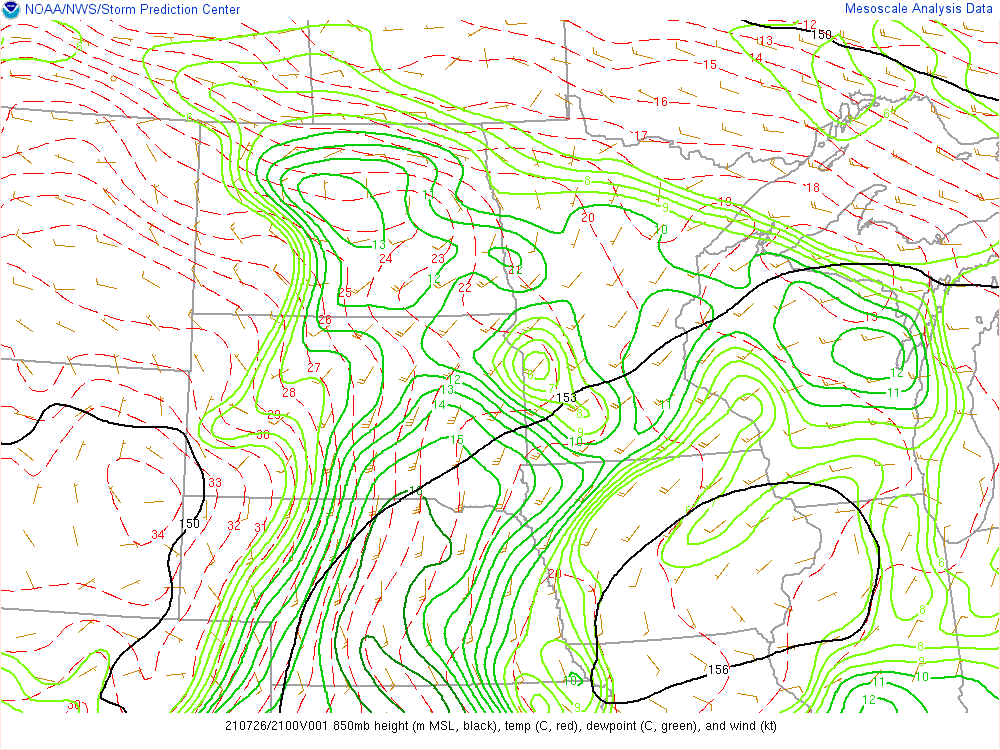 |
| 21Z (4 PM CDT) 300 hPa SPC Mesoanalysis | 21Z (4 PM CDT) 500 hPa SPC Mesoanalysis | 21Z (4 PM CDT) 850 hPa SPC Mesoanalysis |
 |
 |
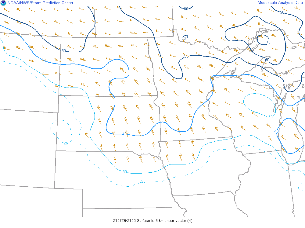 |
| WPC 21Z (4 PM CDT) Surface Analysis | 21Z (4 PM CDT) Surface-Based CAPE from SPC Mesoanalysis | 21Z (4 PM CDT) 0-6 km Bulk Shear from SPC Mesoanalysis |
 |
 |
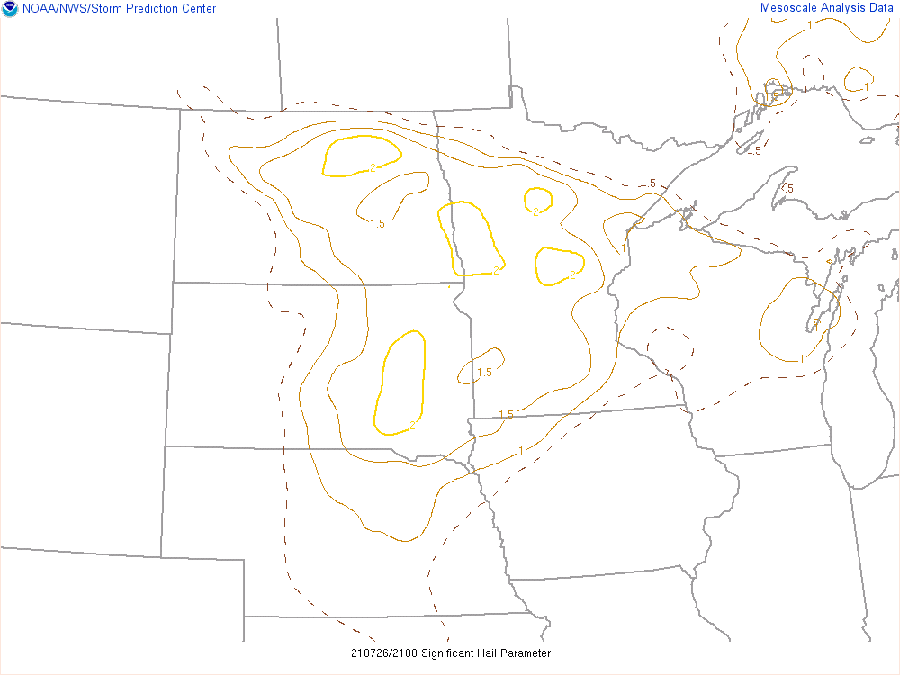 |
| 21Z (4 PM CDT) Effective Bulk Shear from SPC Mesoanalysis | 21Z (4 PM CDT) Supercell Composite Parameter from SPC Mesoanalysis | 21Z (4 PM CDT) SigHail Parameter from SPC Mesoanalysis |
 |
 |
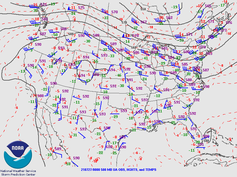 |
| 21Z (4 PM CDT) Hail Parameters from SPC Mesoanalysis | 00Z (7 PM CDT) 250 hPa SPC analysis | 00Z (7 PM CDT) 500 hPa SPC analysis |
 |
||
| Figure 13: 00Z (7 PM CDT) Minneapolis Sounding |
 |
Media use of NWS Web News Stories is encouraged! Please acknowledge the NWS as the source of any news information accessed from this site. |
|

