Overview
|
A strong area of low pressure brought heavy snowfall and very strong winds to much of the Northland starting on Wednesday the 23rd and lingering into Thursday the 24th. This storm was unique in that widespread blizzard conditions occurred across the upper Midwest, including areas from the Brainerd Lakes east towards the North Shore, Twin Ports, and Interstate 35 corridor with many observed wind gusts between 50 and 70 mph. Very strong frontogenesis occurred along a trowal axis that extended across much of northern Wisconsin west into Minnesota. Warm air advection caused temperatures across most of northwest Wisconsin and east-central Minnesota to rise above freezing and produce mixed precipitation for several hours during the day. As the cold front gradually moved east, temperatures very quickly dropped and caused treacherous road conditions as mixed precipitation changed over to snow. Narrow bands of heavy snow set up over the Brainerd Lakes northeast towards the Iron Range during the early morning and early afternoon, and then translated east towards the Twin Ports, North Shore, and Interstate 35 corridor. The heavy snow bands coincided with the strong mid-level frontogenesis, which also produced very strong northwest winds that caused the widespread blizzard conditions. A maximum gust of 70 mph was recorded at the Bay of Grand Marais during the height of the storm. Damage was reported to buildings and other infrastructure, in addition to some power outages and widespread whiteout conditions that made travel difficult if not impossible. As the cold front swept rapidly eastward, bitterly cold air moved into the region and led to the development of a topographically-forced gravity wave during the night of the 23rd that dropped several more inches of snow from Two Harbors to Superior to Holyoke. The highest snowfall report was 13 inches of snow in Holyoke under this band. Further east, lake-effect snow continued into Thursday along the South Shore. Gile, Wisconsin, saw 18.5 inches of snow before lake-effect snow tapered off Thursday evening. |
 Snowfall Totals for the December 23-24, 2020 Storm |
Snow
PUBLIC INFORMATION STATEMENT
NATIONAL WEATHER SERVICE DULUTH MN
421 PM CST THU DEC 24 2020

...UPDATED SNOWFALL REPORTS FROM YESTERDAYS STORM...

LOCATION                     AMOUNT    TIME/DATE       PROVIDER
GILE                         18.5 IN   1115 PM 12/24   CO-OP OBSERVER
HOLYOKE                      13.0 IN   0846 AM 12/24   PUBLIC
WRENSHALL 9.7 SSE            12.3 IN   0700 AM 12/24   COCORAHS
9 WNW HOVLAND                10.0 IN   1022 AM 12/24   TRAINED SPOTTER
5 W WASHBURN                 10.0 IN   0830 AM 12/24   PUBLIC
POPLAR 4.1 WSW               9.5 IN    0700 AM 12/24   COCORAHS
TWO HARBORS                  9.5 IN    0700 AM 12/24   COOP
21 N GRAND MARAIS            9.3 IN    0200 PM 12/24   PUBLIC
3 W BAYFIELD                 9.0 IN    0820 AM 12/24   PUBLIC
POPLAR 2.0 E                 9.0 IN    0700 AM 12/24   COCORAHS
2 NNW MELLEN                 8.8 IN    0241 PM 12/24   TRAINED SPOTTER
BAYFIELD 5.1 NNW             8.5 IN    0700 AM 12/24   COCORAHS
DULUTH 1.2 SE                8.5 IN    0538 AM 12/24   COCORAHS
GRANTSBURG 0.6 SW (KWIGRANT1 8.5 IN    0732 AM 12/24   COCORAHS
3 N AMNICON FALLS S.P.       8.0 IN    0113 AM 12/24   TRAINED SPOTTER
1 NNW LAKE NEBAGAMON         8.0 IN    1147 AM 12/24   PUBLIC
6 SE OLIVER                  8.0 IN    0829 PM 12/23   TRAINED SPOTTER
2 WNW WASHBURN               8.0 IN    0859 AM 12/24   PUBLIC
BAYFIELD 1.7 SW              7.4 IN    0700 AM 12/24   COCORAHS
ELY 25 E                     7.2 IN    0700 AM 12/24   COOP
BABBITT                      7.0 IN    0700 AM 12/24   COOP
BENNETT                      7.0 IN    0343 PM 12/24   PUBLIC
DELTA                        7.0 IN    0834 AM 12/24   PUBLIC
2 SSW ELY                    7.0 IN    0955 AM 12/24   PUBLIC
5 E MELLEN                   7.0 IN    1109 AM 12/24   PUBLIC
SARONA                       7.0 IN    0913 PM 12/23   PUBLIC
SARONA 4.5 NNE               7.0 IN    0700 AM 12/24   COCORAHS
BUYCK                        6.8 IN    0534 PM 12/23   PUBLIC
7 E PINE CITY                6.5 IN    0119 PM 12/24   PUBLIC
3 E WRIGHT                   6.4 IN    0600 AM 12/24   COOP
7 N MCGREGOR                 6.3 IN    0700 AM 12/24   COCORAHS
ASHLAND 0.5 WNW              6.1 IN    0700 AM 12/24   COCORAHS
CHISHOLM 0.4 WSW             6.1 IN    0700 AM 12/24   COCORAHS
1 N CLOQUET                  6.0 IN    1017 PM 12/23   NWS EMPLOYEE
3 NE DULUTH                  6.0 IN    0754 AM 12/24   NWS EMPLOYEE
DULUTH 11.8 NNE              6.0 IN    0800 AM 12/24   COCORAHS
HAYWARD 9.2 NNE              6.0 IN    0600 AM 12/24   COCORAHS
IRON JUNCTION 3.4 NNW        6.0 IN    0700 AM 12/24   COCORAHS
6 N KNIFE RIVER              6.0 IN    1115 AM 12/24   TRAINED SPOTTER
MASON 11.5 WNW               6.0 IN    0800 AM 12/24   COCORAHS
6 NW WEALTHWOOD              6.0 IN    0915 AM 12/24   PUBLIC
WRIGHT 9.2 NNE               6.0 IN    0700 AM 12/24   COCORAHS
KEEWATIN 0.2 SSE             5.9 IN    0800 AM 12/24   COCORAHS
FORT RIPLEY 0.8 N            5.8 IN    0700 AM 12/24   COCORAHS
GRAND MARAIS 4.4 WSW         5.8 IN    0700 AM 12/24   COCORAHS
4 NNW NEW POST               5.8 IN    1003 AM 12/24   TRAINED SPOTTER
SOLON SPRINGS 1.2 W          5.8 IN    0700 AM 12/24   COCORAHS
ELY                          5.7 IN    1123 AM 12/24   TRAINED SPOTTER
2 WNW SPOONER                5.7 IN    0934 AM 12/24   PUBLIC
4 WSW NORTHWOODS BEACH       5.5 IN    1002 AM 12/24   PUBLIC
ASHLAND 9.8 W                5.2 IN    0600 AM 12/24   COCORAHS
1 S CORNUCOPIA               5.2 IN    0832 AM 12/24   TRAINED SPOTTER
12 N ISLE                    5.2 IN    0800 AM 12/24   COOP
3 N MAHTOWA                  5.2 IN    1029 PM 12/23   TRAINED SPOTTER
MELLEN 18.6 SW               5.2 IN    0656 AM 12/24   COCORAHS
NWS DULUTH                   5.2 IN    1200 AM 12/24   OFFICIAL NWS OBSERVATION
ODANAH 1.6 E                 5.2 IN    0700 AM 12/24   COCORAHS
1 WSW BLACKBERRY             5.0 IN    0247 PM 12/24   TRAINED SPOTTER
BLUEBERRY                    5.0 IN    0705 PM 12/23   TRAINED SPOTTER
DULUTH 17.6 NNW              5.0 IN    0530 AM 12/24   COCORAHS
DULUTH 7.9 SW                5.0 IN    0900 AM 12/24   COCORAHS
2 W HAYWARD                  5.0 IN    0739 AM 12/24   TRAINED SPOTTER
HERTEL                       5.0 IN    0838 AM 12/24   PUBLIC
2 SW ISLAND VIEW             5.0 IN    0932 AM 12/24   PUBLIC
3.7 NE SEA GULL LAKE         5.0 IN    0700 AM 12/24   COOP
STONE LAKE 2.0 NW            5.0 IN    0700 AM 12/24   COCORAHS
TAMARACK 1.4 SW              5.0 IN    0700 AM 12/24   COCORAHS
2 SW TWO HARBORS             5.0 IN    1019 AM 12/24   TRAINED SPOTTER
7 NW TWO HARBORS             4.7 IN    0807 PM 12/23   CO-OP OBSERVER
OAKLAND 9.0 ENE              4.6 IN    0700 AM 12/24   COCORAHS
BUTTERNUT 3 N                4.5 IN    0500 AM 12/24   COOP
BRAINERD                     4.1 IN    0700 AM 12/24   COOP
BARNES 2.2 S                 4.0 IN    0700 AM 12/24   COCORAHS
BUTTERNUT 5.9 SW             4.0 IN    0630 AM 12/24   COCORAHS
8 NNW COLERAINE              4.0 IN    0731 AM 12/24   TRAINED SPOTTER
COLERAINE 1.5 S              4.0 IN    0700 AM 12/24   COCORAHS
COOK 8NE                     4.0 IN    0600 AM 12/24   COOP
COTTON                       4.0 IN    0700 AM 12/24   COOP
2 W IRON JUNCTION            4.0 IN    1040 PM 12/23   TRAINED SPOTTER
3 NNE LITTLE ROUND LAKE      4.0 IN    0759 AM 12/24   TRAINED SPOTTER
MERCER 2.0 SE                4.0 IN    0730 AM 12/24   COCORAHS
SOLON SPRINGS                4.0 IN    1116 AM 12/24   PUBLIC
4 SSE WEBSTER                4.0 IN    1154 AM 12/24   TRAINED SPOTTER
5 NNE TALMOON                3.9 IN    0900 AM 12/24   TRAINED SPOTTER
BIG FALLS 1.0 N              3.8 IN    0800 AM 12/24   COCORAHS
BOVEY 13.4 N                 3.8 IN    0652 AM 12/24   COCORAHS
8 SE BRAINERD                3.7 IN    0954 AM 12/24   PUBLIC
CANYON 4.6 NNE               3.5 IN    0800 AM 12/24   COCORAHS
COHASSET 7.6 NNW             3.5 IN    0700 AM 12/24   COCORAHS
COTTON 5.7 ESE               3.5 IN    0800 AM 12/24   COCORAHS
CROSBY 1.1 SW                3.5 IN    0700 AM 12/24   COCORAHS
5 N HAYWARD                  3.5 IN    0825 PM 12/23   TRAINED SPOTTER
MERCER 7.0 NNE               3.2 IN    0700 AM 12/24   COCORAHS
KABETOGAMA 1.5 NW            3.1 IN    0800 AM 12/24   COCORAHS
CASS LAKE                    3.0 IN    0800 AM 12/24   COOP
4 NE EAST GULL LAKE          3.0 IN    1206 PM 12/24   PUBLIC
EMBARRASS                    3.0 IN    0600 AM 12/24   COOP
PILLAGER 5.1 N               3.0 IN    0610 AM 12/24   COCORAHS
ORR 3 E                      2.9 IN    0600 AM 12/24   COOP
AITKIN 9.6 W                 2.8 IN    0800 AM 12/24   COCORAHS
INTERNATIONAL FALLS          2.8 IN    0600 PM 12/23   OFFICIAL NWS OBSERVATION
CELINA 2 E                   2.5 IN    0900 AM 12/24   COOP
7 WSW PINE RIVER             2.5 IN    1130 PM 12/23   TRAINED SPOTTER
CLOQUET 3.4 ENE              2.0 IN    0700 AM 12/24   COCORAHS
GRAND RAPIDS 6.1 N           1.8 IN    0700 AM 12/24   COCORAHS
BRANTWOOD 7.4 S              1.5 IN    0400 AM 12/24   COCORAHS
PHILLIPS 1.3 S               1.5 IN    0600 AM 12/24   COCORAHS
PHILLIPS 0.4 SSW             1.4 IN    0700 AM 12/24   COCORAHS
TROMMALD 6.1 NW              1.4 IN    0800 AM 12/24   COCORAHS
3 NE NISSWA                  1.0 IN    0700 AM 12/24   UCOOP

OBSERVATIONS ARE COLLECTED FROM A VARIETY OF SOURCES WITH VARYING
EQUIPMENT AND EXPOSURES. WE THANK ALL VOLUNTEER WEATHER OBSERVERS
FOR THEIR DEDICATION. NOT ALL DATA LISTED ARE CONSIDERED OFFICIAL.

$$
Wind
PUBLIC INFORMATION STATEMENT
NATIONAL WEATHER SERVICE DULUTH MN
1113 AM CST THU DEC 24 2020

...HIGHEST WIND REPORTS OVER LAST 24 HOURS...

LOCATION                     SPEED     TIME/DATE       PROVIDER
GRAND MARAIS                 70 MPH    0656 PM 12/23   NDBC
1 SSE SILVER BAY             66 MPH    0540 PM 12/23   NDBC
DULUTH HARBOR                60 MPH    0536 PM 12/23   NOS-NWLON
CLOQUET AIRPORT              58 MPH    0535 PM 12/23   AWOS
BRAINERD AIRPORT             56 MPH    0653 PM 12/23   ASOS
DULUTH INTERNATIONAL AIRPORT 55 MPH    0655 PM 12/23   ASOS
DULUTH SKY HARBOR AIRPORT    54 MPH    0415 PM 12/23   AWOS
BLATNIK BRIDGE SOUTH ABUTMEN 53 MPH    0619 PM 12/23   MNDOT
DEVILS ISLAND                53 MPH    0500 PM 12/23   NDBC
BLATNIK BRIDGE               52 MPH    0551 PM 12/23   MNDOT
ATKINSON BRIDGE I-35 MILE PO 47 MPH    0510 PM 12/23   MNDOT
CHISHOLM-HIBBING AIRPORT     47 MPH    0749 PM 12/23   ASOS
DULUTH I-35 AND GARFIELD RWI 45 MPH    0228 PM 12/23   MNDOT
GRAND MARAIS AIRPORT         45 MPH    0855 PM 12/23   AWOS
GRAND RAPIDS AIRPORT         45 MPH    0656 PM 12/23   AWOS
MCGREGOR AIRPORT             45 MPH    0635 PM 12/23   AWOS
CASS LAKE US-2 MILE POST 131 44 MPH    0220 PM 12/23   MNDOT
MOOSE LAKE AIRPORT           44 MPH    0555 PM 12/23   AWOS
DULUTH 1.8 NE                43 MPH    0616 PM 12/23   CWOP
1 WSW VIRGINIA               42 MPH    0521 PM 12/23   MNDOT
ANDERSON ROAD RWIS           41 MPH    0435 PM 12/23   MNDOT
INTERNATIONAL FALLS AIRPORT  40 MPH    0354 PM 12/23   ASOS
HIBBING RAWS                 39 MPH    0907 PM 12/23   RAWS
PLINY MN-65 MILE POST 98     39 MPH    0135 PM 12/23   MNDOT
1 N PORT WING                39 MPH    0240 AM 12/24   NDBC
WALKER MN AWOS               39 MPH    1155 AM 12/23   AWOS
BRAINERD RAWS                38 MPH    1206 PM 12/23   RAWS
HINCKLEY AIRPORT             38 MPH    0455 PM 12/23   AWOS
NORTHOME                     38 MPH    1015 PM 12/23   CWOP
ST. CROIX RAWS               38 MPH    0515 PM 12/23   RAWS
4 NE DULUTH                  37 MPH    0533 PM 12/23   CWOP
MITCHELL BRIDGE MN-169 MILE  37 MPH    0720 PM 12/23   MNDOT
AITKIN AIRPORT               36 MPH    0215 PM 12/23   AWOS
EVELETH-VIRGINIA AIRPORT     36 MPH    1255 AM 12/24   AWOS
ISABELLA RAWS                36 MPH    0804 PM 12/23   RAWS
LA POINTE AIRPORT            36 MPH    0535 PM 12/23   AWOS
LIND RAWS                    36 MPH    0706 PM 12/23   RAWS
PINE RIVER AIRPORT           36 MPH    0119 PM 12/23   AWOS
COTTON US-53 MILE POST 41    35 MPH    0126 PM 12/23   MNDOT
HILL CITY RAWS               35 MPH    0607 PM 12/23   RAWS
SUPERIOR AIRPORT             35 MPH    0335 PM 12/23   AWOS
TWIG MN-53 MILE POST 21      35 MPH    0220 PM 12/23   MNDOT

OBSERVATIONS ARE COLLECTED FROM A VARIETY OF SOURCES WITH VARYING
EQUIPMENT AND EXPOSURES. WE THANK ALL VOLUNTEER WEATHER OBSERVERS
FOR THEIR DEDICATION. NOT ALL DATA LISTED ARE CONSIDERED OFFICIAL.

$$
Photos and Video
Damage Photos
 |
 |
 |
| A large spruce tree that was downed by the 60-70 mph wind gusts in Grand Marais. (Kelsey Kennedy photo) |
A large spruce tree that was downed by the 60-70 mph wind gusts in Grand Marais. (Kelsey Kennedy photo) |
A photo of the tree on a much nicer day showing how large it was. (Kelsey Kennedy photo) |
 |
 |
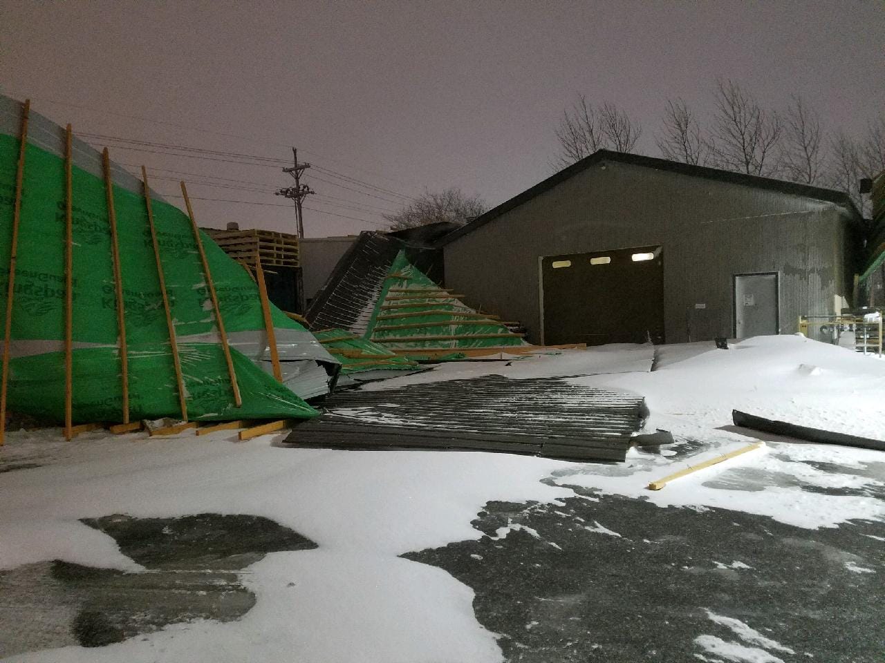 |
| A roof was peeled off a building by the winds on the north side of Superior. (Debbie Johnson photo) |
A roof was peeled off a building by the winds on the north side of Superior. (Debbie Johnson photo) |
A roof was peeled off a building by the winds on the north side of Superior. (Debbie Johnson photo) |
Video
Video of the height of the blizzard at the Duluth Ship Canal.
(Source: Dennis O'Hara/duluthharborcam.com)
Environment
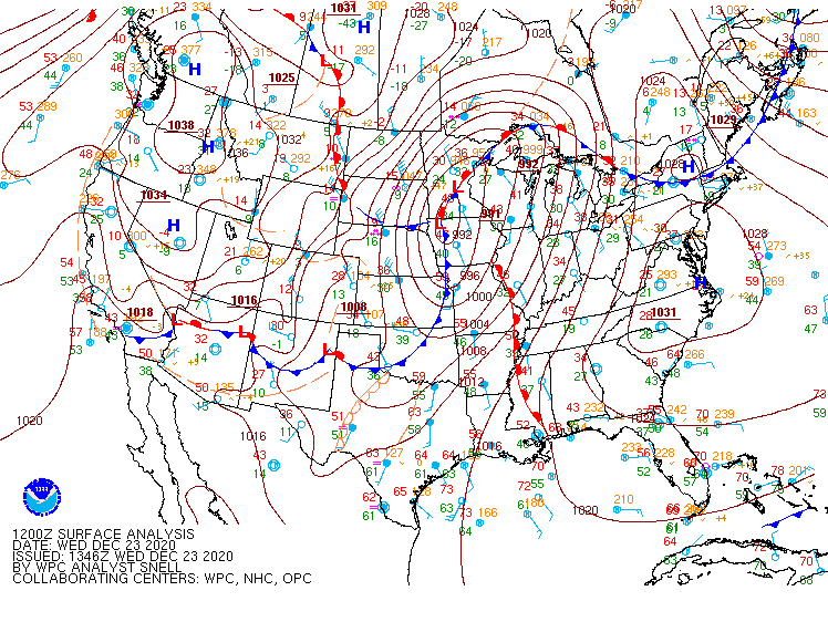
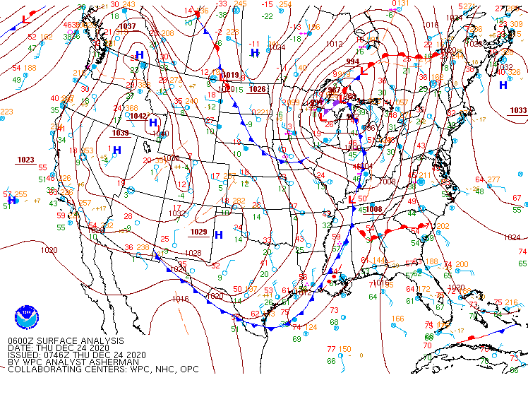
Surface analyses during the event.
 |
 |
 |
| 12z 12/23 Surface Analysis | 18z 12/23 Surface Analysis | 00z 12/24 Surface Analysis |
 |
 |
|
| 06z 12/24 Surface Analysis | 12z 12/24 Surface Analysis |
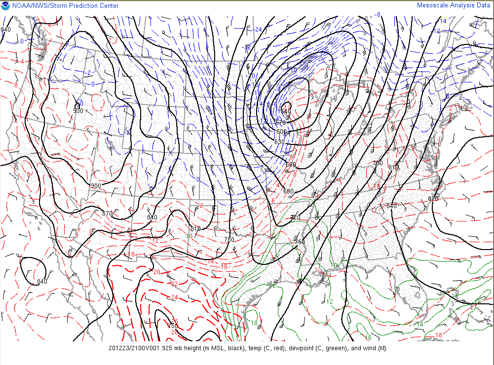
Upper-air data at 20z.
 |
 |
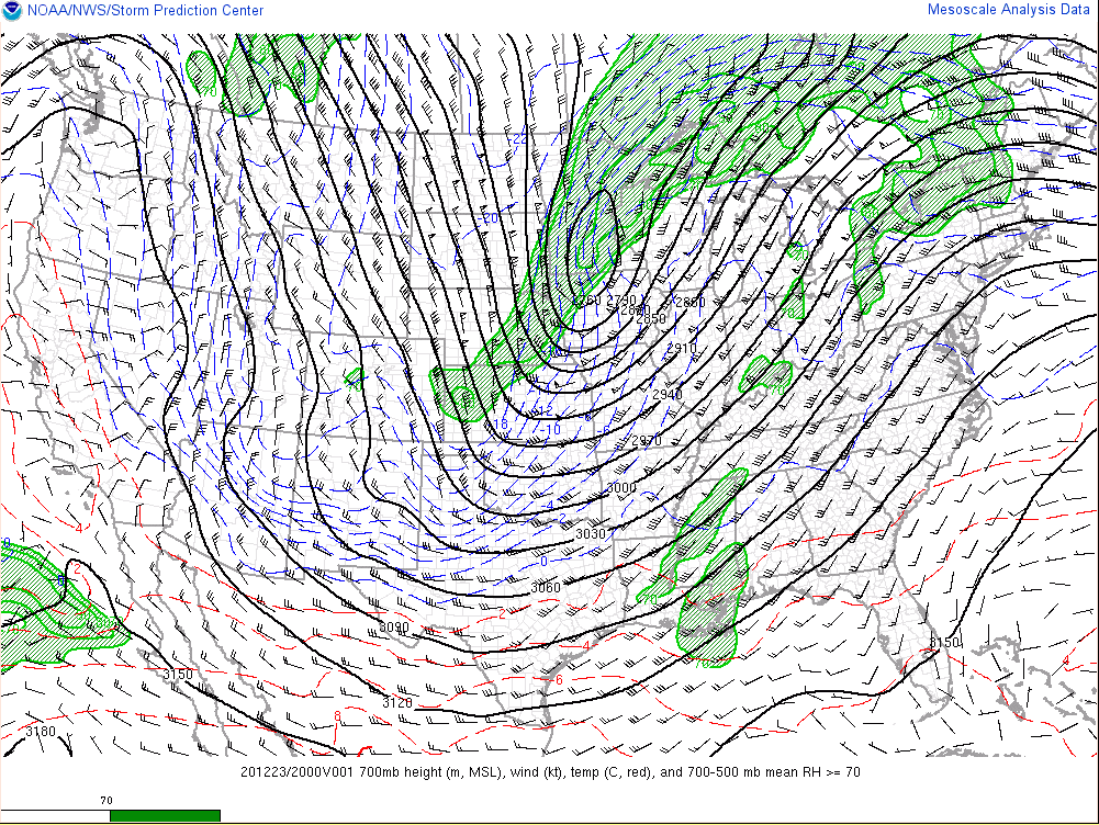 |
| 20z 12/23 300mb | 20z 12/23 500mb | 20z 12/23 700mb |
 |
 |
|
| 20z 12/23 850mb | 20z 12/23 925mb |
Observed sounding data.
 |
 |
| The 12z/6AM 12/23 observed sounding from MPX showing strong mid-level lapse rates and a surface layer primed to mix out and bring strong winds to the surface. This is the airmass that moved into the Northland later in the day. | The 00z 12/24 / 6PM 12/23 observed sounding from MPX depicting the very strong winds at the top of the mixed layer and the stout inversion at the top of the layer. |
 |
Media use of NWS Web News Stories is encouraged! Please acknowledge the NWS as the source of any news information accessed from this site. |
|

