
Severe thunderstorms today may produce damaging winds, large hail, tornadoes, and flooding over parts of the Plains into the Missouri Valley. On Sunday, scattered severe thunderstorms capable of damaging wind gusts are expected across the Mid-Atlantic vicinity. Hazardous heat will continue in the South, Southwest and central California this weekend building across the Pacific Northwest Sunday. Read More >
Overview
|
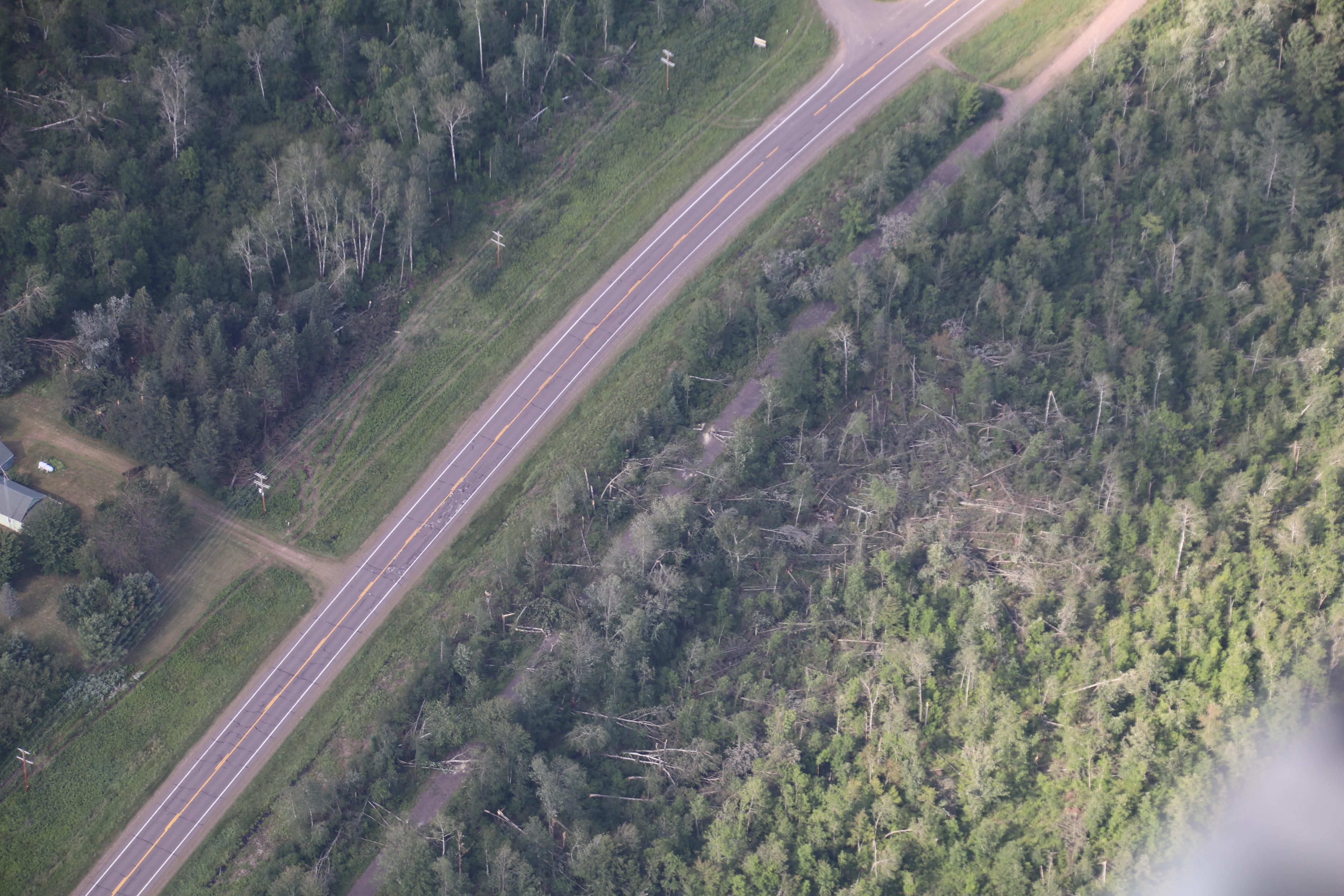
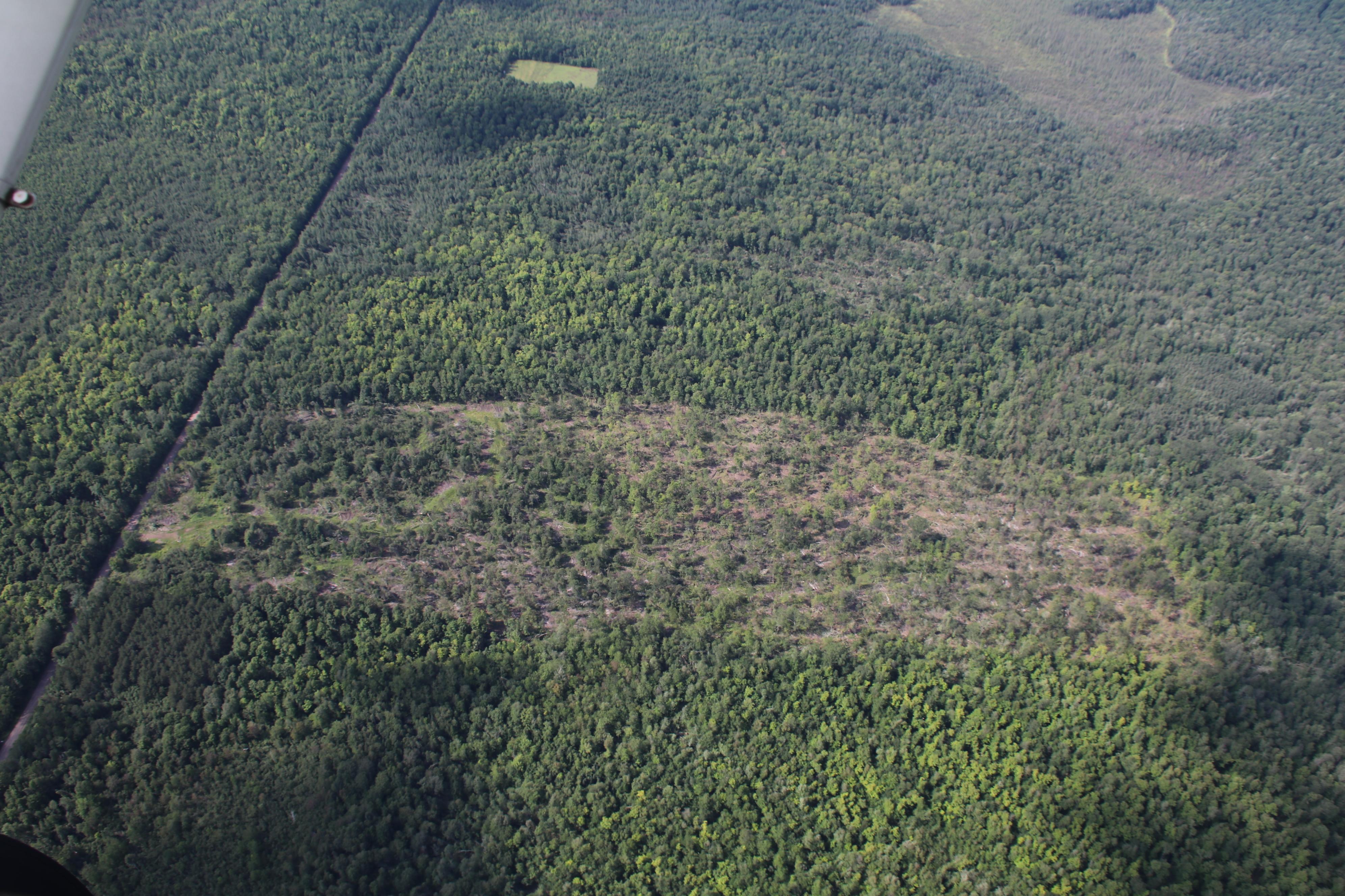
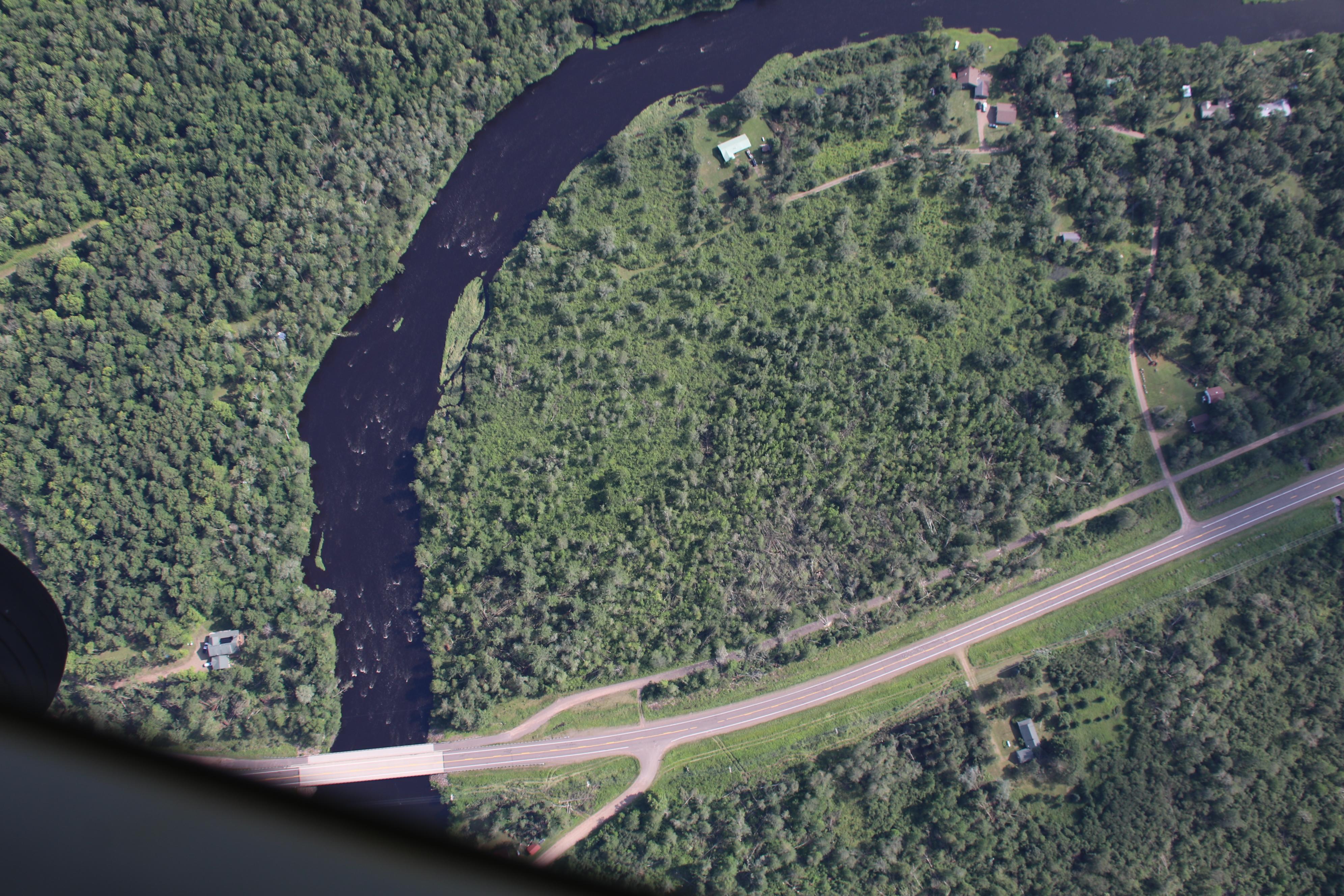
During the late afternoon and early evening of July 19, 2019, thunderstorms developed over north central Minnesota and quickly spread eastward and southeastward. One supercell thunderstorm moved through Pine County in Minnesota and produced significant wind and hail damage, especially near the Rock Creek area. This storm continued to move over far southern portions of Burnett County producing damaging winds. Another supercell thunderstorm moved from Douglas County southeast through Sawyer and through Price Counties in northwest Wisconsin producing significant wind and hail damage. Behind this supercell, a line of storms developed producing strong winds as things wrapped up during the evening. We extend our thanks to Pine and Sawyer County Emergency Management and Wisconsin Emergency Management for their considerable assistance in documenting and assessing this weather event. |
 Numerous trees downed near County Road H and King Creek in Radisson, WI. (photo courtesy Wisconsin State Patrol and Wisconsin Department of Natural Resources) |
Wind & Hail:
Wind
Numerous reports of wind damage across Pine
 |
.jpg) |
 |
 |
| Damage from a microburst taken by NWS Duluth Damage Survey team near the intersection of 570th Street and County Highway 3 in Pine City, MN. | Tree split near the base on the south shore of Pokegama Lake in MN.(photo courtesy Kenny Reed) | Numerous trees downed in Ojibwa, WI. (photo courtesy Pat Sanchez) | Numerous trees downed near Camp One Creek and County Road H in New Post, WI. (photo courtesy Wisconsin State Patrol and Wisconsin Department of Natural Resources) |
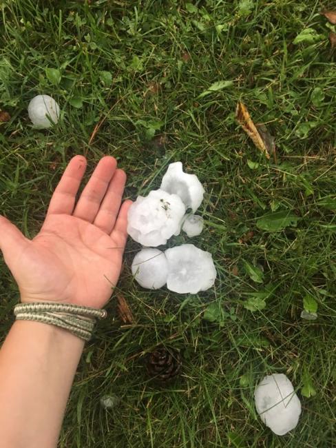
Hail
Numerous reports of large hail and wind driven hail damaging homes and vehicles.
 |
 |
 |
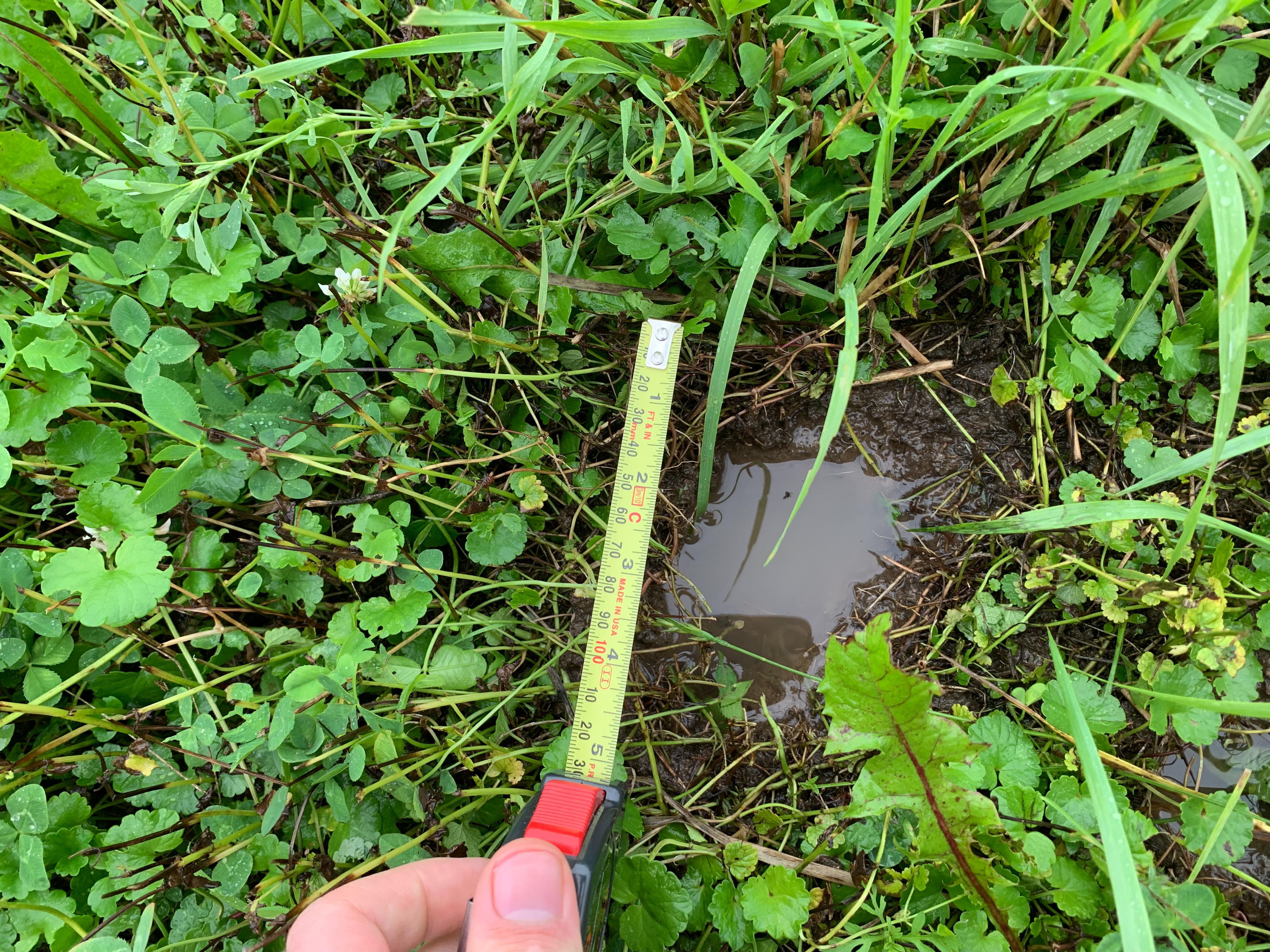 |
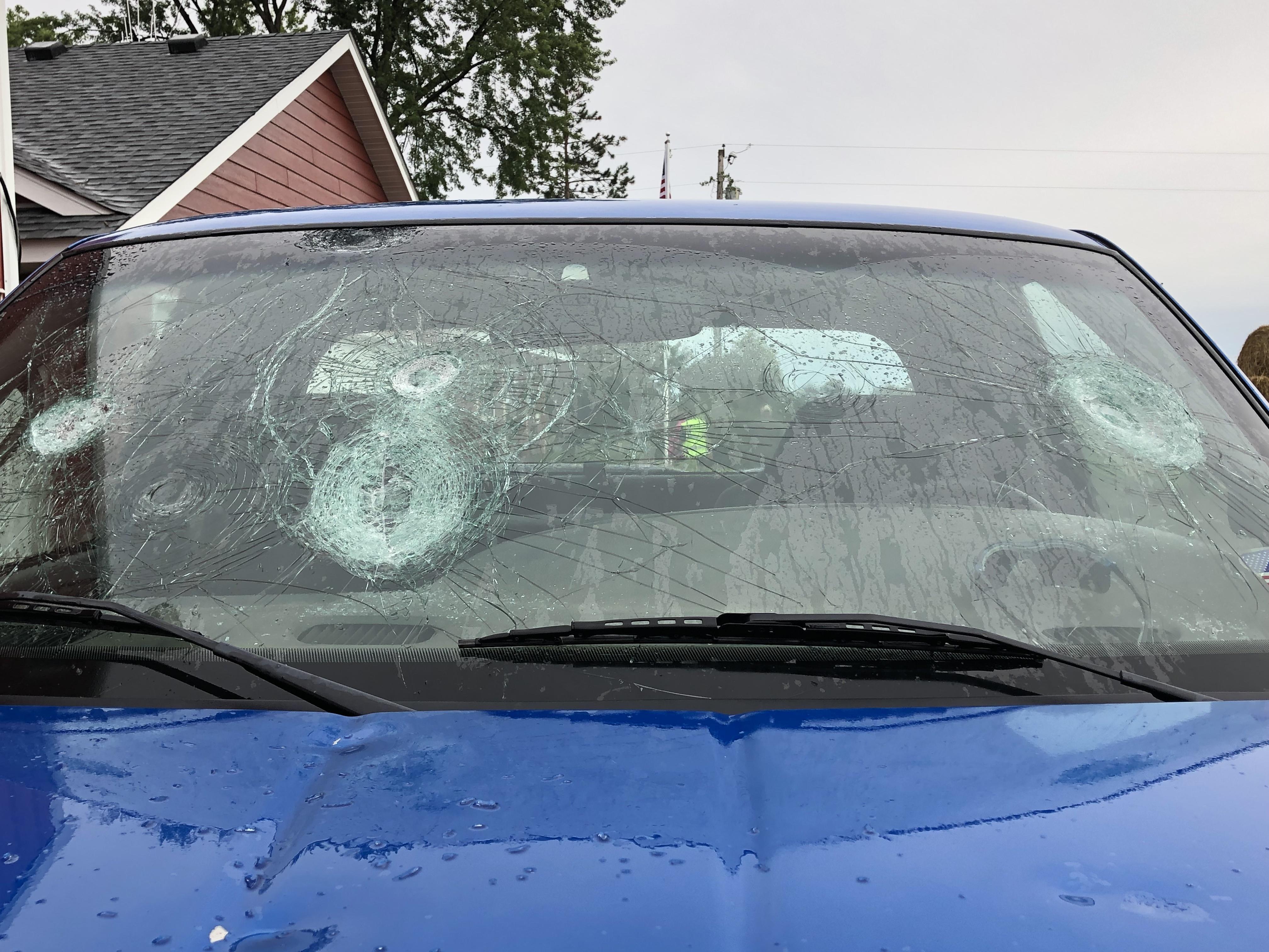
| Home damaged by wind driven hail in Rock Creek, MN. Photo taken by NWS Duluth Damage Survey team. | Windshield damaged by hailstones in Rock Creek, MN. Photo taken by NWS Duluth Damage Survey team. | Hailstones in Winter, WI. (photo courtesy Pat Sanchez) | Divot from large hailstones in Rock Creek, MN. Photo taken by NWS Duluth Damage Survey team. |
Photos & Video
Additional damage photos.
 |
 |
 |
 |
| Windshield damaged by hailstones in Pine City, MN. (photo courtesy KBJR meteorologist Jenna Lake) |
Numerous trees downed in Ojibwa, WI along Scout Trail. (photo courtesy Wisconsin State Patrol and Wisconsin Department of Natural Resources) |
Numerous trees downed near the Helsing Road and Crooked Rapids Creek in Ojibwa, WI. (photo courtesy Wisconsin State Patrol and Wisconsin Department of Natural Resources) |
Trees downed in Ojibwa, WI along WI-27. (photo courtesy Wisconsin State Patrol and Wisconsin Department of Natural Resources) |
Radar
There were two storms that caused the majority of the damage today in the Duluth CWA. The first (left image) developed near the Brainerd Lakes and moved southeastward across Pine and Burnett counties. The second (right image) developed over southern Aitkin County and moved east across northern Pine county. Eventually the storm dived southeastward across Douglass, Burnett, Sawyer and Price counties.
 |
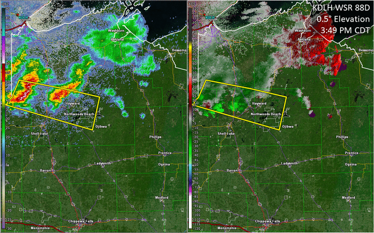 |
| Reflectivity (left) and Base Velocity (right) of the supercell that moved through Pine and Burnett Counties. Radar loop begins at 3:35 PM CDT and ends at 5:39 PM CDT. | Reflectivity (left) and Base Velocity (right) of a hybrid supercell and bow echo which eventually merged into a larger derecho later on. Storm move through Douglas, Burnett, Sawyer and Price counties. Radar loop beings at 3:49 PM CDT and ends at 6:47 PM CDT. |
Storm Reports
NWUS53 KDLH 200348
LSRDLH

PRELIMINARY LOCAL STORM REPORT...SUMMARY
NATIONAL WEATHER SERVICE DULUTH MN
1048 PM CDT FRI JUL 19 2019

..TIME...   ...EVENT...      ...CITY LOCATION...     ...LAT.LON...
..DATE...   ....MAG....      ..COUNTY LOCATION..ST.. ...SOURCE....
            ..REMARKS..

0440 PM     HAIL             PINE CITY               45.83N 92.97W
07/19/2019  M2.75 INCH       PINE               MN   TRAINED SPOTTER

            .

0445 PM     HAIL             3 NE ROCK CREEK         45.79N 92.93W
07/19/2019  M2.50 INCH       PINE               MN   TRAINED SPOTTER

            GOLF BALL TO TENNIS BALL SIZE HAIL. BROKEN
            WINDOW ON NORTH SIDE OF HOME.

0440 PM     HAIL             1 ESE WEST ROCK         45.76N 93.00W
07/19/2019  M2.50 INCH       PINE               MN   TRAINED SPOTTER

            CROPS ARE FLATTENED.

0605 PM     HAIL             5 SW PHILLIPS           45.64N 90.47W
07/19/2019  M2.00 INCH       PRICE              WI   TRAINED SPOTTER

            HAIL HAD ABOUT 20-30 MINUTES OF MELT ON IT
            WHEN FOUND.

0519 PM     HAIL             WINTER                  45.82N 91.01W
07/19/2019  M2.00 INCH       SAWYER             WI   PUBLIC

            .

0528 PM     HAIL             2 SSE WINTER            45.80N 90.99W
07/19/2019  M1.75 INCH       SAWYER             WI   CO-OP OBSERVER


0517 PM     HAIL             4 NW WINTER             45.86N 91.07W
07/19/2019  E1.75 INCH       SAWYER             WI   PUBLIC

            THIS REPORT CORRECTS AN INCORRECT TIME ON A
            PREVIOUSLY SENT LSR. DELAYED REPORT FROM
            MPING. TIME ESTIMATED BY RADAR.

0500 PM     HAIL             2 W FOUR CORNERS        45.67N 92.62W
07/19/2019  M1.75 INCH       BURNETT            WI   TRAINED SPOTTER

            CEDAR POINT RESORT.

0448 PM     HAIL             5 ENE ROCK CREEK        45.78N 92.87W
07/19/2019  M1.75 INCH       PINE               MN   TRAINED SPOTTER

            TIME ESTIMATED BY RADAR.

0430 PM     HAIL             2 NE HENRIETTE          45.89N 93.10W
07/19/2019  M1.75 INCH       PINE               MN   TRAINED SPOTTER

            .

0454 PM     HAIL             2 WSW GRANTSBURG        45.77N 92.72W
07/19/2019  M1.50 INCH       BURNETT            WI   PUBLIC

            REPORT RELAYED VIA FACEBOOK. TIME ESTIMATED
            BY RADAR.

0449 PM     HAIL             4 E PINE CITY           45.83N 92.89W
07/19/2019  M1.50 INCH       PINE               MN   PUBLIC


0611 PM     HAIL             4 S PHILLIPS            45.64N 90.39W
07/19/2019  M1.25 INCH       PRICE              WI   PUBLIC

            OCCURRING AT THE TIME OF THE REPORT.

0500 PM     HAIL             4 W BRANSTAD            45.74N 92.76W
07/19/2019  E1.25 INCH       BURNETT            WI   TRAINED SPOTTER

            HAIL WAS COVERING THE GROUND. MOST STONES
            WERE QUARTER SIZED, BUT THE LARGEST WERE
            HALF DOLLAR. TIME ESTIMATED BY RADAR.

0428 PM     HAIL             1 NNW HENRIETTE         45.89N 93.13W
07/19/2019  M1.25 INCH       PINE               MN   TRAINED SPOTTER


0615 PM     HAIL             1 S PHILLIPS            45.68N 90.39W
07/19/2019  M1.00 INCH       PRICE              WI   TRAINED SPOTTER

            A FEW QUARTER SIZE HAIL STONES.

0509 PM     HAIL             WINTER                  45.82N 91.01W
07/19/2019  M1.00 INCH       SAWYER             WI   PUBLIC


0508 PM     HAIL             4 NW WINTER             45.86N 91.07W
07/19/2019  M1.00 INCH       SAWYER             WI   PUBLIC

            REPORT VIA MPING.

0434 PM     HAIL             3 W PINE CITY           45.82N 93.04W
07/19/2019  M1.00 INCH       PINE               MN   PUBLIC

            .

0430 PM     HAIL             2 NNW WEST ROCK         45.79N 93.04W
07/19/2019  M1.00 INCH       PINE               MN   PUBLIC


0347 PM     HAIL             1 N FORT RIPLEY         46.18N 94.36W
07/19/2019  M1.00 INCH       CROW WING          MN   TRAINED SPOTTER

            .

0425 PM     HAIL             1 ENE BROOK PARK        45.96N 93.05W
07/19/2019  M0.75 INCH       PINE               MN   TRAINED SPOTTER

            .

0505 PM     HAIL             5 ENE CHIEF LAKE        45.96N 91.25W
07/19/2019  M0.70 INCH       SAWYER             WI   TRAINED SPOTTER


0323 PM     HAIL             3 SSE PINE CENTER       46.18N 93.89W
07/19/2019  E0.70 INCH       CROW WING          MN   TRAINED SPOTTER

            .

0732 PM     TSTM WND DMG     1 WNW OGEMA             45.45N 90.31W
07/19/2019                   PRICE              WI   PUBLIC

            FEW TREES KNOCKED DOWN NEAR THE INTERSECTION
            OF COUNTY ROAD O AND HIGHWAY 13. TIME
            ESTIMATED BY RADAR.

0708 PM     TSTM WND DMG     4 N CATAWBA             45.60N 90.54W
07/19/2019                   PRICE              WI   TRAINED SPOTTER

            EIGHT INCH DIAMETER TREE KNOCKED DOWN ON A
            POWER LINE APPROXIMATELY 5 MILES NORTH OF
            CATAWBA ON COUNTY ROAD J. TIME ESTIMATED BY
            RADAR.

0625 PM     FUNNEL CLOUD     3 SSW PRENTICE          45.50N 90.31W
07/19/2019                   PRICE              WI   LAW ENFORCEMENT


0616 PM     FUNNEL CLOUD     1 WNW PRENTICE          45.55N 90.32W
07/19/2019                   PRICE              WI   LAW ENFORCEMENT

            FUNNEL CLOUD REPORTED NEAR THE INTERSECTION
            OF HIGHWAY 13 AND HIGHWAY 8 NEAR PRENTICE.

0552 PM     TSTM WND DMG     8 SW SHELL LAKE         45.65N 92.03W
07/19/2019                   WASHBURN           WI   LAW ENFORCEMENT

            TREES KNOCKED DOWN NEAR SHALLOW LAKE. TIME
            ESTIMATED BY RADAR.

0510 PM     TSTM WND DMG     2 NE RADISSON           45.79N 91.18W
07/19/2019                   SAWYER             WI   TRAINED SPOTTER

            MANY TREES DOWN 60 TO 80 TREES. TREES ON
            POWER LINES AND POWER IS OUT.

0448 PM     TSTM WND DMG     5 ENE ROCK CREEK        45.78N 92.87W
07/19/2019                   PINE               MN   TRAINED SPOTTER

            LOTS OF TREES DOWNED AND ONE FELL THROUGH A
            RENTAL TRAILER ROOF. TIME ESTIMATED BY
            RADAR.

0441 PM     TSTM WND DMG     1 ESE WEST ROCK         45.76N 93.00W
07/19/2019                   PINE               MN   EMERGENCY MNGR

            EXTENSIVE TREE DAMAGE NEAR FALCON AVENUE. IN
            ADDITION, 3 BUILDINGS HEAVILY DAMAGED. TIME
            ESTIMATED BY RADAR.

0439 PM     TSTM WND DMG     NORTHWOODS BEACH        45.91N 91.40W
07/19/2019                   SAWYER             WI   EMERGENCY MNGR

            SEVERAL TREES AND POWER LINES KNOCKED DOWN
            IN THE NORTHWOODS BEACH AREA. TIME ESTIMATED
            BY RADAR.

0429 PM     TSTM WND DMG     3 SSW HAYWARD           45.96N 91.50W
07/19/2019                   SAWYER             WI   LAW ENFORCEMENT

            FEW TREES KNOCKED DOWN. TIME ESTIMATED BY
            RADAR.
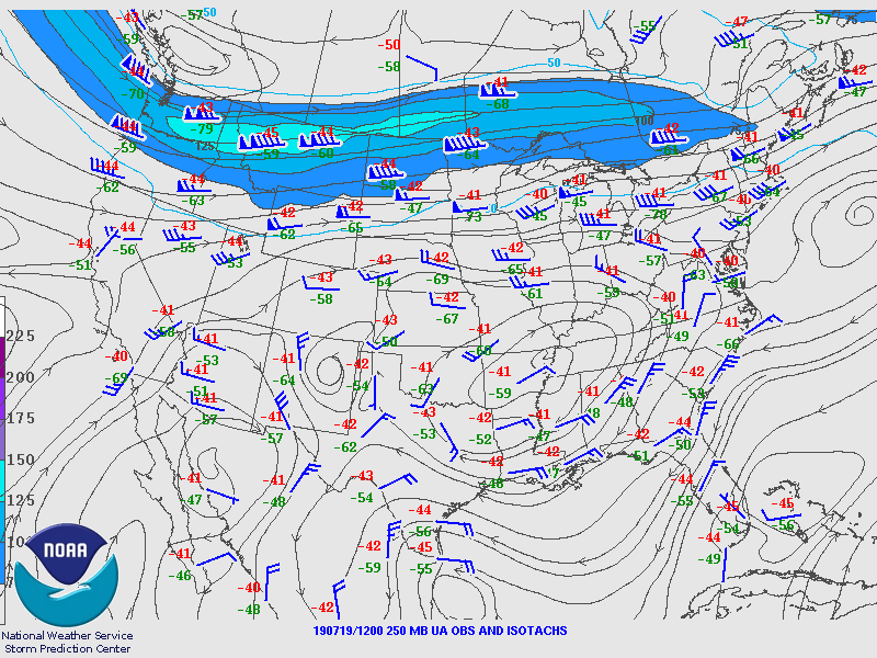
Environment
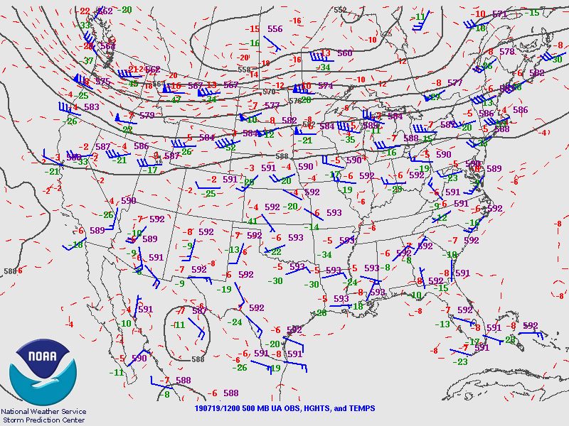
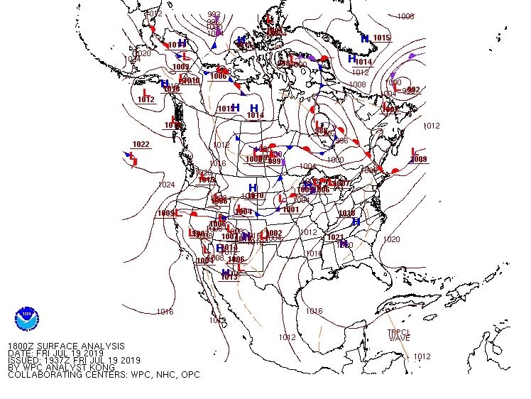
A 250 hPa jet was oriented along the International Border from the Pacific Northwest to Maine. A subtle 500 hPa shortwave was lifting across the eastern Dakotas into the Upper Mississippi River Valley. At 850 hPa a quasi-stationary front (also seen at the surface) can be seen extending through central Minnesota into northern Wisconsin. The southern side of the front featured strong southerly moisture and temperature advection. At the surface a stationary front extended from southeast south Dakota through southern Minnesota into northern Wisconsin and Upper Michigan.
 |
 |
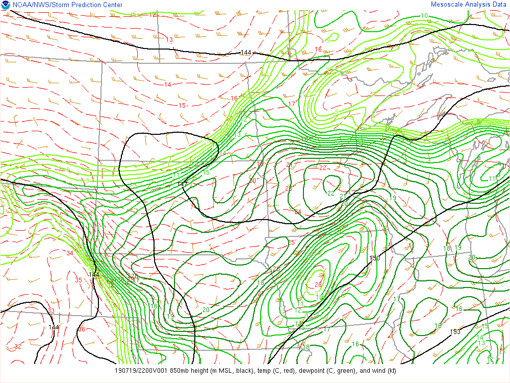 |
| Figure 1: 12 Z (7 AM CDT) 250 hPa SPC analysis | Figure 2: 12 Z (7 AM CDT) 500 hPa SPC analysis | Figure 3: 21 Z (4 PM CDT) 850 hPa SPC Mesoanalysis |
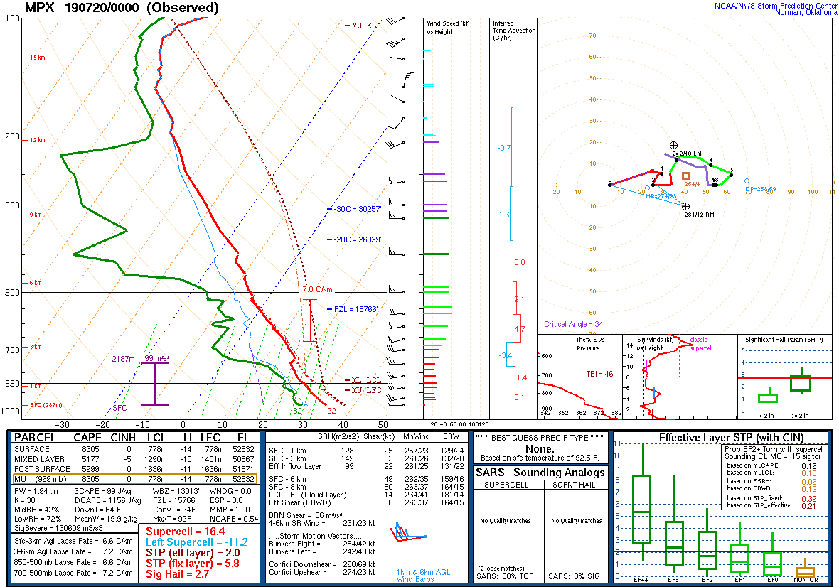
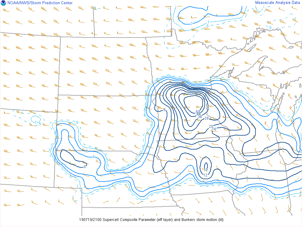
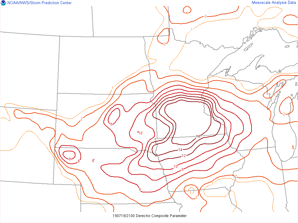
The Minneapolis sounding at 7 PM showed Surface Based CAPE values of 8305 J/kg with 0-6 km bulk shear values of 49 kts, making this an explosive environment. Mixed Layer CAPE values around 4 PM were a gradient from 500 J/kg from northern Wisconsin to central Minnesota to 4000 J/kg from central Minnesota to southeast Wisconsin. 0-6 km bulk shear values (not shown) were 50 to 60 knots which is conducive for severe storms to develop. The other three composite parameters (Supercell Composite, Derecho Composite and Significant Hail) all show a similar gradient from central Minnesota extending southeastward into southern Wisconsin. These were all extremely high values as well, showing an environment that was ripe for supercell development, a long lived derecho being possible and large hail. Storms developed along the gradient region and slid along it through this event. This was due to the strong frontogenesis going on within the gradient.
 |
 |
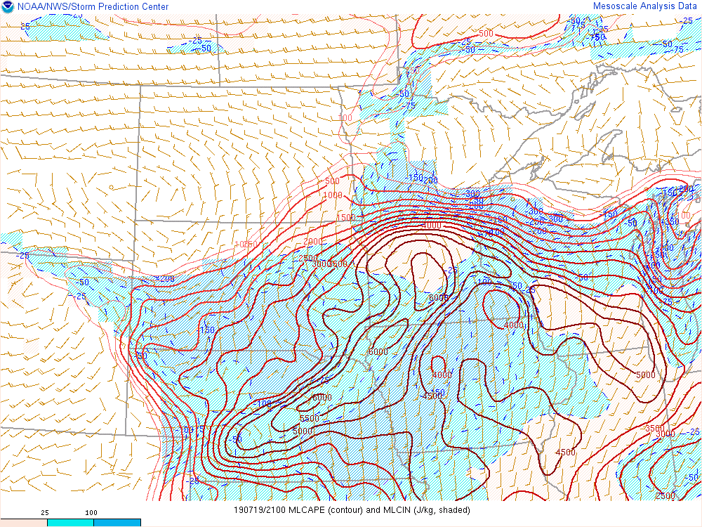 |
| Figure 4: 18 Z (1 PM CDT) WPC Surface Analysis | Figure 5: 00 Z (7 PM CDT) MPX (Twin Cities) Sounding | Figure 6: 21 Z (4 PM CDT) Mixed Layer CAPE from SPC Mesoanalysis |
 |
 |
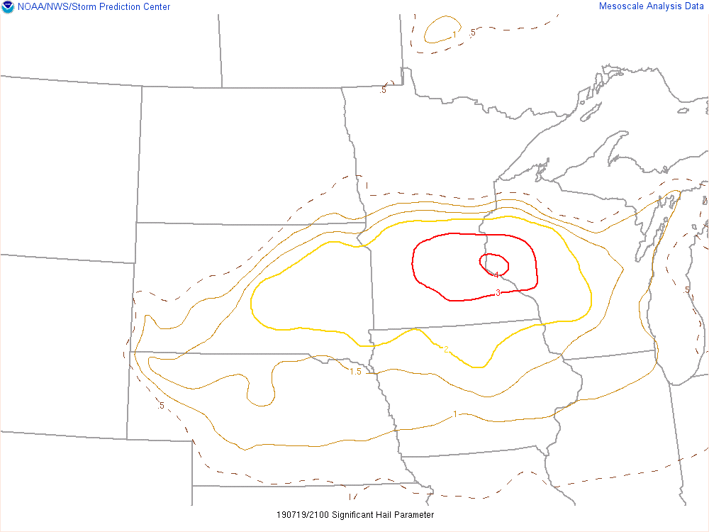 |
| Figure 7: 21 Z (4 PM CDT) Supercell Composite Parameter from SPC Mesoanalysis | Figure 8: 21 Z (4 PM CDT) Derecho Composite Parameter from SPC Mesoanalysis | Figure 9: 21 Z (4 PM CDT) Significant Hail Parameter from SPC Mesoanalysis |
 |
Media use of NWS Web News Stories is encouraged! Please acknowledge the NWS as the source of any news information accessed from this site. |
|

