Overview
|
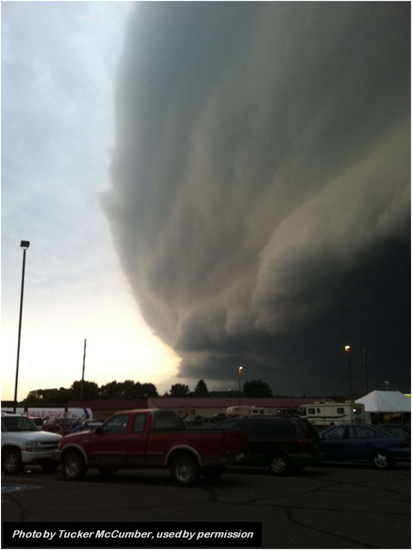
On July 1, 2011, several lines of severe thunderstorms swept across parts of Minnesota, Wisconsin, Lake Superior, Upper Michigan, Iowa, and South Dakota. The first line of storms was especially severe, and it produced a corridor of wind damage from northwest of Sioux Falls, South Dakota, all the way into northwest Wisconsin and western Lake Superior. Many communities in east-central Minnesota and northwest Wisconsin were impacted by significant wind damage, caused by hurricane-force wind gusts. Fast Facts -The National Weather Service in Duluth received over 40 reports of severe weather. -One tornado was confirmed in northwest Wisconsin, an EF2 tornado southwest of Solon Springs. -The vast majority of the damage from these storms was associated with straight-line, non-tornadic wind gusts. -Burnett County, Wisconsin, was one of the hardest hit areas with widespread wind damage. Based on a survey of the damage, wind speeds in parts of Burnett County were estimated to have exceeded 100 mph. -The National Weather Service in Duluth issued 1 Tornado Warning, 18 Severe Thunderstorm Warnings, 2 Flash Flood Warnings, and 5 Special Marine Warnings. A Tornado Warning was in effect for the area damaged by the tornado. The preliminary average lead time along the tornado path was 22.5 minutes. -Severe Thunderstorm Warnings were in effect along the entire path of the damaging line of storms. The preliminary combined average lead time for all the wind gusts and wind damage reports associated with the line of storms was approximately 32 minutes. The line of storms had a stunning visual appearance as they raced through the area at forward speeds of over 60 mph. Many residents observed a shelf cloud, something that is a common occurrence on the leading edge of a strong line of thunderstorms. The shelf cloud usually marks the leading edge of the strong thunderstorm outflow winds. |
 Event Radar Loop |
 |
 |
 |
 |
| The shelf cloud near Spooner, Wisconsin. (Nancy Olson photo) |
The shelf cloud near Spooner, Wisconsin. (Tucker McCumber photo) |
Shelf cloud approaching Grantsburg, Wisconsin. (Ron Wilhelm photo) |
Shelf cloud approaching Grantsburg, Wisconsin. (Ron Wilhelm photo) |
Tornado
|
Tornado - Solon Springs, WI
Track Map  
KDLH Base Reflectivity image from 7:51pm CDT
KDLH Storm-Relative Velocity image from 7:51pm CDT
NWS survey photo of damage along Bill Ramel Road
NWS survey photo of damage along Bill Ramel Road |
||||||||||||||||
|
||||||||||||||||
The Enhanced Fujita (EF) Scale classifies tornadoes into the following categories:
| EF0 Weak 65-85 mph |
EF1 Moderate 86-110 mph |
EF2 Significant 111-135 mph |
EF3 Severe 136-165 mph |
EF4 Extreme 166-200 mph |
EF5 Catastrophic 200+ mph |
 |
|||||
Wind Damage
The line of severe thunderstorms that moved through Pine County, Minnesota, and northwest Wisconsin, produced widespread, non-tornadic wind damage. Such winds are also often referred to as "straight-line winds" or "downburst winds". The damage included some areas of very intense forest blowdown. The National Weather Service in Duluth conducted a storm damage assessment the following day in parts of Pine, Burnett, Washburn, and Douglas Counties. This assessment was aided by aerial flyovers of the damage by the Burnett County Sheriff's Department. Both the ground and air assessments concluded that the damage across the area was caused by widespread, non-tornadic, straight line wind gusts in excess of 60 mph, with smaller pockets of intense winds in excess of 100 mph.

Based on a combination of information from aerial and ground surveys, as well as spotter reports, we have created a map of the swaths of the most intense wind damage associated with these thunderstorms. Generally, these areas were a few miles wide and consisted of "straight-line" or diverging damage patterns.
Over the entire area pictured on the map there was at least sporadic tree damage, and wind gusts were likely into the 50 to 60 mph range at most spots. In the first level of shading, damage was observed to be more concentrated, and these were areas where many trees were damaged or blown over. Winds in those areas were likely closer to 70-80 mph. In the second level of shading, there was a combination of more intense tree damage and damage to a few structures. Winds were likely between 80 and 100 mph in those spots. And in the darkest level of shading, corridors of severe forest blowdown existed. Winds in those spots likely exceeded 100 mph.
The EF-2 tornado track near Solon Springs is also plotted in red.
Keep in mind that there will be some areas that aren't shaded that may have experienced much smaller areas of significant wind damage. However, in general, the shaded areas in the map represent the areas where the greatest concentration of damage existed.
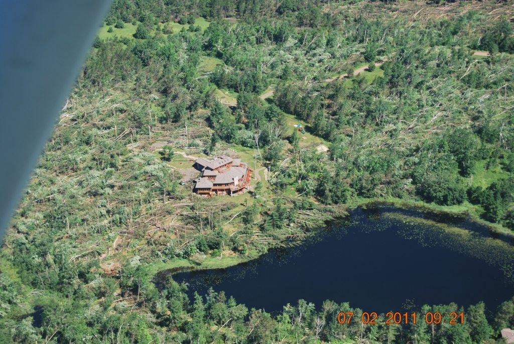
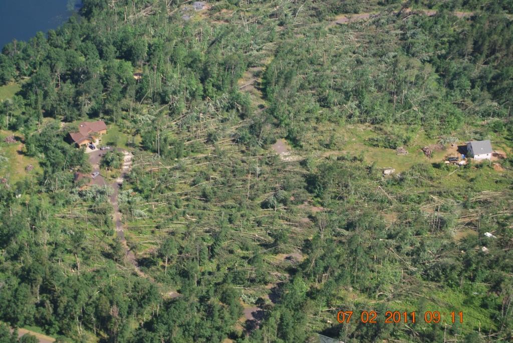
Aerial Photographs
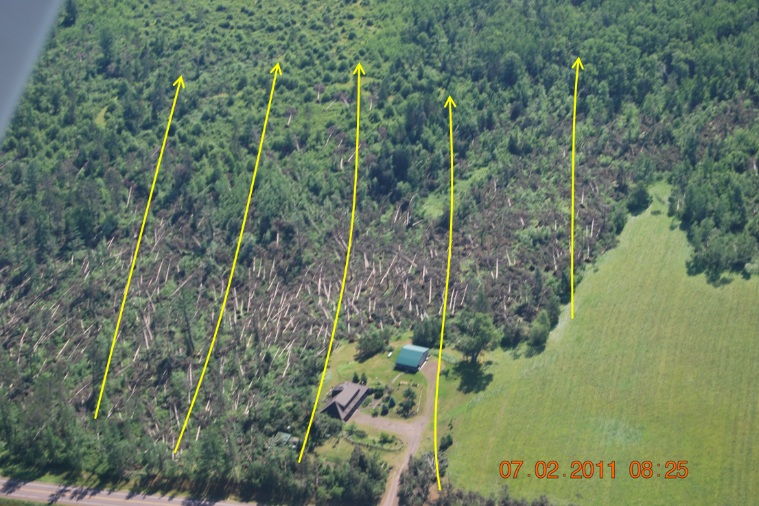
Often times when meteorologists are assessing storm damage, aerial photographs can be extremely valuable in determining the extent and cause of the damage. This is especially true in parts of northeast Minnesota and northwest Wisconsin where large tracts of forest can limit the area of a ground survey. In this particular case, the aerial photographs revealed widespread wind damage. Non-tornadic damage will involve the vast majority of trees or objects being blown in a similar direction. Special thanks go to the Burnett County Sheriff's Department for conducting the flyover of the damage, and providing these images to National Weather Service meteorologists.
First, here are some annotated versions of the aerial photographs showing approximate damage vectors (the direction trees and objects were blown).
 |
 |
 |
 |
 |
 |
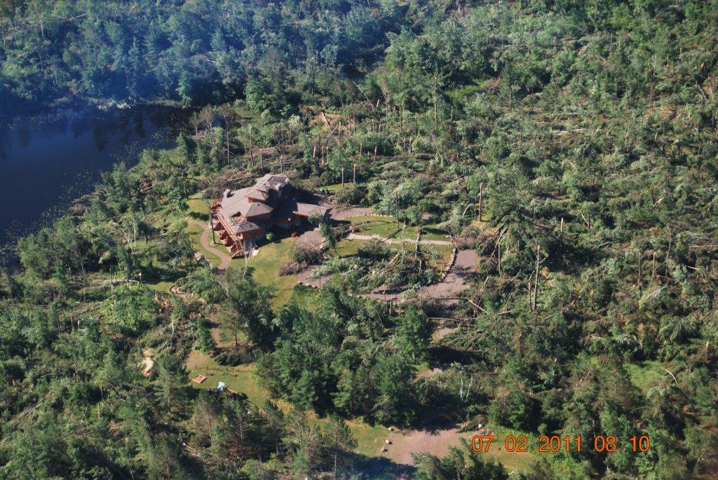
Here are some unedited versions of aerial photographs from around the Burnett County area. Photos were taken by Stacy Hopke of the Burnett County Sheriff's Department.
 |
 |
 |
 |
 |
 |
 |
 |
 |
 |
 |
 |
 |
 |
 |
Ground Survey Photographs
National Weather Service meteorologists also conducted a ground survey. Here are some pictures from that survey.
 |
 |
 |
 |
 |
 |
Storm Reports
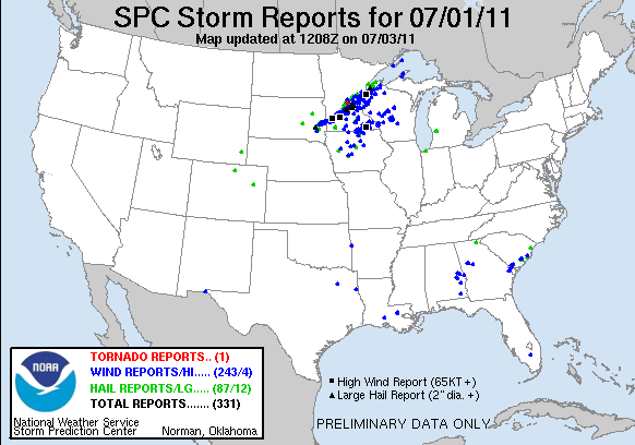
Click the image above for Storm Reports from around the country.
PRELIMINARY LOCAL STORM REPORT...SUMMARY
NATIONAL WEATHER SERVICE DULUTH MN
935 AM CDT SAT JUL 02 2011

..TIME...   ...EVENT...      ...CITY LOCATION...     ...LAT.LON...
..DATE...   ....MAG....      ..COUNTY LOCATION..ST.. ...SOURCE....
            ..REMARKS..

0613 PM     HAIL             15 E HINCKLEY           46.01N 92.63W
07/01/2011  M3.00 INCH       PINE               MN   TRAINED SPOTTER

            LARGEST HAILSTONE SIZE 3.5 INCHES MEASURED.

0634 PM     HAIL             SUPERIOR                46.70N 92.06W
07/01/2011  M0.88 INCH       DOUGLAS            WI   TRAINED SPOTTER

            39TH AND US HIGHWAY 2

0645 PM     HAIL             SUPERIOR                46.70N 92.06W
07/01/2011  E1.25 INCH       DOUGLAS            WI   BROADCAST MEDIA

            ESTIMATED FROM A SUBMITTED PHOTO.

0704 PM     TSTM WND DMG     PINE CITY               45.83N 92.97W
07/01/2011                   PINE               MN   LAW ENFORCEMENT

            NUMEROUS TREES DOWN IN PINE CITY AND TO THE EAST. PINE
            COUNTY SHERIFF. CORRECTED TIME.

0705 PM     HAIL             HAWTHORNE               46.50N 91.86W
07/01/2011  M2.50 INCH       DOUGLAS            WI   BROADCAST MEDIA

            SUBMITTED PHOTO...MEASURED TO BE 2.5 INCHES.

0705 PM     TSTM WND GST     4 SW HINCKLEY           45.98N 93.00W
07/01/2011  M45.00 MPH       PINE               MN   PUBLIC

            MEASURED ON A PRIVATE WEATHER STATION.

0705 PM     HAIL             HAWTHORNE               46.50N 91.86W
07/01/2011  M2.00 INCH       DOUGLAS            WI   BROADCAST MEDIA

            HAIL SLIGHTLY LARGER THAN GOLF BALL SIZE. FROM A
            SUBMITTED PHOTO.

0708 PM     HAIL             HAWTHORNE               46.50N 91.86W
07/01/2011  M1.00 INCH       DOUGLAS            WI   TRAINED SPOTTER

            ROUTE 53 AND COUNTY ROAD B

0714 PM     TSTM WND DMG     GRANTSBURG              45.78N 92.68W
07/01/2011                   BURNETT            WI   LAW ENFORCEMENT

            NUMEROUS TREES DOWN AND POWER OUT.

0714 PM     TSTM WND DMG     GRANTSBURG              45.78N 92.68W
07/01/2011                   BURNETT            WI   AMATEUR RADIO

            TREES UP TO 2 FEET IN DIAMETER BLOWN DOWN...SOME ROADS
            IMPASSIBLE DUE TO TREES BLOWN INTO ROADS.

0716 PM     HAIL             2 W MAPLE               46.59N 91.76W
07/01/2011  M1.00 INCH       DOUGLAS            WI   TRAINED SPOTTER

0716 PM     HAIL             BRULE                   46.55N 91.58W
07/01/2011  M1.00 INCH       DOUGLAS            WI   TRAINED SPOTTER

0717 PM     TSTM WND DMG     15 E HINCKLEY           46.01N 92.63W
07/01/2011                   PINE               MN   TRAINED SPOTTER

            MANY 2 FOOT DIAMTER TREES DOWN

0717 PM     TSTM WND DMG     8 E HINCKLEY            46.01N 92.77W
07/01/2011                   PINE               MN   LAW ENFORCEMENT

            NUMEROUS TREES DOWN EAST OF HINCKLEY. PINE COUNTY SHERIFF
            DISPATCH. CORRECTED TIME AND LOCATION.

0718 PM     TSTM WND DMG     TRADE LAKE              45.69N 92.59W
07/01/2011                   BURNETT            WI   TRAINED SPOTTER

            SIGNIFICANT WIND DAMAGE. NUMEROUS TREES BLOWN DOWN. BOATS
            FLIPPED AND BLOWN ON SHORE. SPOTTER INDICATED THIS WAS
            LIKELY STRAIGHT LINE WIND DAMAGE.

0720 PM     TSTM WND DMG     GRANTSBURG              45.78N 92.68W
07/01/2011                   BURNETT            WI   TRAINED SPOTTER

            3.5 ACRE YARD HAS LOST NEARLY EVERY TREE SOME LARGE OAK
            TREES OVER 50 YEARS OLD. DAMAGE LOOKS LIKE STRAIGHT LINE
            WINDS. FIREWORKS TENT BLOWN OVER. CORRECTED TIME.

0720 PM     HAIL             HERBSTER                46.83N 91.26W
07/01/2011  E1.75 INCH       BAYFIELD           WI   BROADCAST MEDIA

            IN THE HERBSTER AREA. TIME ESTIMATED FROM RADAR.

0721 PM     TSTM WND DMG     5 W WEBSTER             45.88N 92.47W
07/01/2011                   BURNETT            WI   TRAINED SPOTTER

            COUNTY ROAD F AND FF. TREES DOWN. SIDING COMING OFF HIS
            HOUSE. ROOF DAMAGE.

0723 PM     TSTM WND DMG     WEBB LAKE               46.01N 92.13W
07/01/2011                   BURNETT            WI   AMATEUR RADIO

            MANY LARGE TREES BLOWN DOWN...INCLUDING 18 INCH DIAMETER
            NORWAY PINES.

0724 PM     TSTM WND GST     4 NNE RANDALL           45.74N 92.80W
07/01/2011  M51.00 MPH       BURNETT            WI   MESONET

            MEASURED AT THE LIND RAWS SITE.

0725 PM     TSTM WND DMG     DANBURY                 46.01N 92.37W
07/01/2011                   BURNETT            WI   PUBLIC

            TREES BLOWN DOWN...SEVERAL FALLING ON CARS OR STRUCTURES.
            MOBILE HOME DAMAGED. RELAYED BY MEDIA.

0730 PM     TSTM WND DMG     1 N ASKOV               46.20N 92.78W
07/01/2011                   PINE               MN   AMATEUR RADIO

            LARGE TREES BLOWN DOWN.

0745 PM     TSTM WND DMG     MINONG                  46.10N 91.82W
07/01/2011                   WASHBURN           WI   AMATEUR RADIO

            ROOF BLOWN OFF A BUSINESS ALONG HIGHWAY 53.

0750 PM     TSTM WND GST     3 WSW MINONG FLOWAGE    46.14N 91.98W
07/01/2011  M56.00 MPH       WASHBURN           WI   MESONET

            MEASURED AT THE MINONG RAWS SITE.

0750 PM     MARINE TSTM WIND 1 N PORT WING           46.79N 91.39W
07/01/2011  E46.00 MPH       BAYFIELD           WI   MESONET

            MEASURED AT PORT WING MARINE OB. 40 KT GUST.

0750 PM     TSTM WND DMG     WASCOTT                 46.17N 91.80W
07/01/2011                   DOUGLAS            WI   PUBLIC

            NUMEROUS TREES BLOWN DOWN. SOME POWER LINES ALSO DOWN.

0755 PM     HAIL             MAPLE                   46.59N 91.72W
07/01/2011  M1.00 INCH       DOUGLAS            WI   PUBLIC

0755 PM     TSTM WND DMG     SOLON SPRINGS           46.35N 91.82W
07/01/2011                   DOUGLAS            WI   AMATEUR RADIO

            AIRPORT HANGAR COLLAPSED. ROOF BLOWN OFF A BUILDING AND
            FOUND LAYING 1/8 MILE TO THE EAST.

0755 PM     TSTM WND DMG     SOLON SPRINGS           46.35N 91.82W
07/01/2011                   DOUGLAS            WI   AMATEUR RADIO

            POWER OUT. NUMEROUS TREES DOWN. CORRECTED TIME.

0804 PM     TSTM WND DMG     HAYWARD                 46.01N 91.48W
07/01/2011                   SAWYER             WI   TRAINED SPOTTER

            MANY TREES DOWN

0805 PM     TSTM WND DMG     5 N DRUMMOND            46.40N 91.26W
07/01/2011                   BAYFIELD           WI   TRAINED SPOTTER

            NUMEROUS TREES DOWN AROUND BARNES WISCONSIN. CORRECTED
            TIME.

0805 PM     TSTM WND DMG     4 WSW UPPER EAU CLAIRE  46.28N 91.55W
07/01/2011                   DOUGLAS            WI   PUBLIC

            TREES BLOWN DOWN. SOME TREES TOOK DOWN POWER LINES.

0805 PM     TSTM WND DMG     HAYWARD                 46.01N 91.48W
07/01/2011                   SAWYER             WI   BROADCAST MEDIA

            STOP SIGN SNAPPED OFF ON MAIN STREET. CORRECTED TIME.

0809 PM     HAIL             CLOVERLAND              46.68N 91.68W
07/01/2011  M1.00 INCH       DOUGLAS            WI   AMATEUR RADIO

0810 PM     TSTM WND DMG     6 S TREGO               45.81N 91.82W
07/01/2011                   WASHBURN           WI   AMATEUR RADIO

            LARGE BILLBOARD BLOWN DOWN.

0810 PM     TSTM WND DMG     6 E HAYWARD             46.01N 91.36W
07/01/2011                   SAWYER             WI   AMATEUR RADIO

            STRAIGHT LINE WINDS ESTIMATED BETWEEN 50 AND 60 MPH.
            POWER IS OUT. NUMEROUS TREES DOWN.

0820 PM     TSTM WND DMG     5 SE HAYWARD            45.96N 91.41W
07/01/2011                   SAWYER             WI   AMATEUR RADIO

            NUMEROUS TREES BLOWN DOWN AND UPROOTED. POWER LINES DOWN.
            ACROSS MUCH OF WESTERN SAWYER COUNTY. CORRECTED TIME AND
            LOCATION.

0820 PM     TSTM WND GST     2 ENE HAYWARD           46.02N 91.45W
07/01/2011  M46.00 MPH       SAWYER             WI   MESONET

            MEASURED AT THE HAYWARD RAWS SITE.

0827 PM     TSTM WND GST     4 W CLAM LAKE           46.16N 91.00W
07/01/2011  M47.00 MPH       BAYFIELD           WI   CO-OP OBSERVER

            41 KNOT WIND GUST.

0835 PM     TSTM WND DMG     SANBORN                 46.43N 90.91W
07/01/2011                   ASHLAND            WI   AMATEUR RADIO

            TREES BLOWN DOWN BLOCKING COUNTY ROAD B.

0842 PM     TSTM WND GST     3 SW ASHLAND            46.55N 90.92W
07/01/2011  M53.00 MPH       ASHLAND            WI   ASOS

            46 KNOT PEAK WIND AT ASHLAND AIRPORT.

0850 PM     TSTM WND DMG     ASHLAND                 46.58N 90.87W
07/01/2011                   ASHLAND            WI   BROADCAST MEDIA

            NUMEROUS TREES DOWN. CORRECTED TIME.

0855 PM     MARINE TSTM WIND W LA POINTE             46.78N 90.79W
07/01/2011  E49.00 MPH       ASHLAND            WI   PUBLIC

            MEASURED AT THE MADELEINE ISLAND FERRY DOCK.

0907 PM     TSTM WND DMG     2 NNW BUTTERNUT         46.04N 90.51W
07/01/2011                   ASHLAND            WI   BROADCAST MEDIA

            TREES AND POWER LINES DOWN NORTH OF BUTTERNUT ALONG
            HIGHWAY 13.

0940 PM     MARINE TSTM WIND DEVILS ISLAND           47.07N 90.73W
07/01/2011  M44.00 MPH       ASHLAND            WI   C-MAN STATION


&&

AN UPDATED SUMMARY WITH THE REPORTS FROM LAST NIGHTS STORMS.

$$
Environment
July 1st was a very hot and humid day across much of Minnesota and Wisconsin. High temperatures were in the 90s in many locations. The Duluth Airport recorded a high of 91 degrees - the first 90 degree high temperature there in approximately 5 years. The high at Minneapolis was 99 degrees.
The heat was accompanied by an abundance of low level moisture. Surface dew points were well into the 70s, and values as high as 79 were recorded in parts of north central Wisconsin. The combination of heat and humidity lead to heat index values as high as 110 in some locations and the development of an extremely unstable air mass.
By mid afternoon, a weakly defined front extended from western Ontario, along the north shore of Lake Superior, into central Minnesota, and into eastern South Dakota. This would eventually become the focus for widespread thunderstorm development. Rapid thunderstorm development initially occurred very close to this front to the northwest of Sioux Falls, South Dakota, around 2 PM as a strong mid-level low pushed into the area. These storms quickly became severe and then tracked northeast up the front.
Within an hour, the storms had rapidly formed into a compact line and began producing extremely strong and damaging winds. While a relatively broad corridor received wind damage and gusts probably in excess of 60 mph, there were also smaller swaths of very intense wind damage along much of the path through Minnesota and northwest Wisconsin. These areas of significant damage were generally related to more substantial downbursts.
Some scattered supercells that formed ahead of the main line of storms along the front also produced some very large hail in central Minnesota and northwest Wisconsin. There were a few reports of hail between the size of baseballs and softballs.
In total, several hundred wind damage and wind gusts reports were received along a roughly 500 mile long area in the region. Many of these reports included significant damage, with large stands of trees blown down, and some damage to structures.
Historic Forest Blowdown Events
Areas of northeast Minnesota and northwest Wisconsin are susceptible to forest blowdown events from time to time, some more severe than others. One can pretty easily compare the damage photos from Burnett County on July 1, 2011, to photographs from several other major forest blowdowns in the area. In all those events, broad swaths of trees were removed from the existing forest. However, in this particular case, the forest damage was not as widespread across the area as the examples provided below.
July 4, 1999: Minnesota Arrowhead and Boundary Waters


The intense wind damage that occurred in the Boundary Waters Canoe Area Wilderness will be remembered in northeast Minnesota for a long time. A large forest blowdown occurred very near the US-Canada border in the Minnesota Arrowhead in early July 1999. Prior to the storm reaching the Boundary Waters, it affected parts of the lakes region around and north of Brainerd, as well as the Iron Range. Damages in Cass, Itasca, and Aitkin Counties exceed $3 million (in 1999 dollars). The Hibbing Airport measured a wind gust to 81 mph and sustained some structural damage. In the Boundary Waters, over 600 square miles of forest and over 10 million trees were blown down. Dozens of people were injured by falling trees.

The line of storms eventually crossed through southern Ontario and Quebec, and re-entered the United States the following day in parts of Vermont, New Hampshire, and Maine. For more information, here is a writeup from the NWS Duluth (3.4MB PDF), as well as a web page from the Storm Prediction Center.
July 4, 1977: East Central Minnesota and Northwest Wisconsin


Another famous forest blowdown event occurred back in 1977. The storms moved from far eastern North Dakota through central Minnesota, northern Wisconsin, and into lower Michigan. The damage from this event was surveyed by Dr. T. Theodore Fujita, a meteorology professor from the University of Chicago, and the person for whom the Fujita Scale is named. One of his damage maps is shown above (on the right). He surveyed significant damage from Sawyer County into Price County, Wisconsin, where wind speeds from the line of storms were likely in excess of 100 mph.
The image above left is from the Storm Prediction Center web page on this event.
Fujita, 1978: Manual of downburst identification for project NIMROD. Satellite and Mesometeorology Res. Pap. No. 156, University of Chicago, Dept. of Geophysical Sciences, pp. 104.
 |
Media use of NWS Web News Stories is encouraged! Please acknowledge the NWS as the source of any news information accessed from this site. |
|


