
Gusty winds and very dry conditions will lead to a critical to extremely critical fire weather threat over portions of the Central and Southern Plains Thursday. Critical fire weather continues through Friday. Moderate to heavy mountain snow and strong winds will expand into the Northern Rockies Thursday, then into Colorado by Friday. Up to a foot of snow accumulation is possible. Read More >
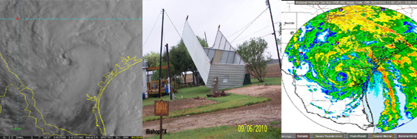
Tropical Depression Hermine was a unique storm in that it formed as a result of the remnants of Tropical Depression number eleven in the Pacific crossing into the Southwest Gulf of America on Sunday September 5, 2010. Hermine quickly gained strength becoming a strong tropical storm with winds of 60 mph in just 15 hours, and made landfall in northeast Mexico exactly 24 hours after it formed on Monday evening, September 6. The tropical storm then turned northward and moved quickly across south Texas into the Texas Hill Country on Tuesday September 7, bringing torrential rainfall, damaging winds and high tides.
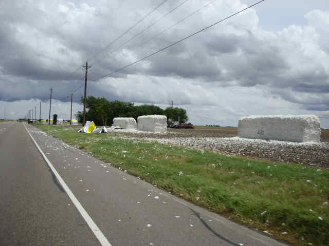
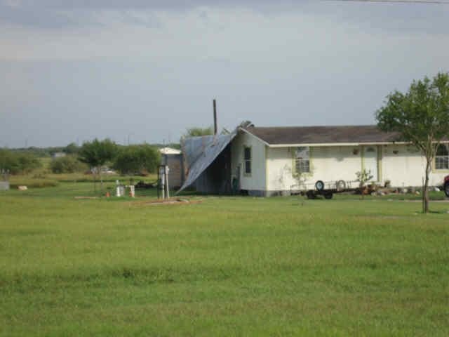
The corridor of strongest winds spanned an area along the South Texas Coast from near Brownsville to San Antonio. Wind gusts of 50 to 70 mph were reported along the track. Damage was confined primarily to trees, signs, and metal buildings. Hardest hit areas were the cities of Bishop and Orange Grove where the eyewall tracked directly overhead. The storm knocked out power to approximately 20,000 customers in the Coastal Bend.
The heaviest rains fell across the northeast Coastal Bend near Victoria and Seadrift where 4 to 6 inches were reported. Approximately 2-3 inches fell across the central coastal bend generally east if Highway 281.
Although a few tornado warnings were issued based on radar signatures, there were no confirmed tornadoes.
The strong winds and high surf caused tide levels to peak around 3.5 feet mean sea level along the barrier islands and near 3 feet msl over the inland bays. This is about 2 feet above normal. The higher than normal tides resulted in minor flooding of area beaches and beach access roads and low areas around the inland bays.
Hermine continued tracking northward into north central Texas Tuesday night and produced life threatening flash floods between Austin and Waco. A large swath of 10 to 15 inches of rain fell in those areas.
Overall, the Coastal Bend faired very well from this storm, but it serves as a reminder that storms can develop very quickly and that Coastal Bend residents should remain in a constant state of readiness, especially during the peak months of the Hurricane Season.

|
KCRP Radar Reflectivity loop beginning at 204 AM CDT on 09/07/10 and ending at 1051 AM CDT on 09/07/10. |
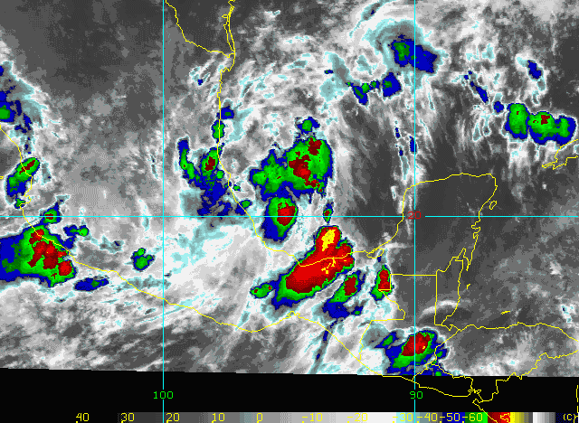
| Infrared Satellite loop beginning at 932 PM CDT on 09/05/10 and ending at 632 AM CDT on 09/08/10. |
 |
 |
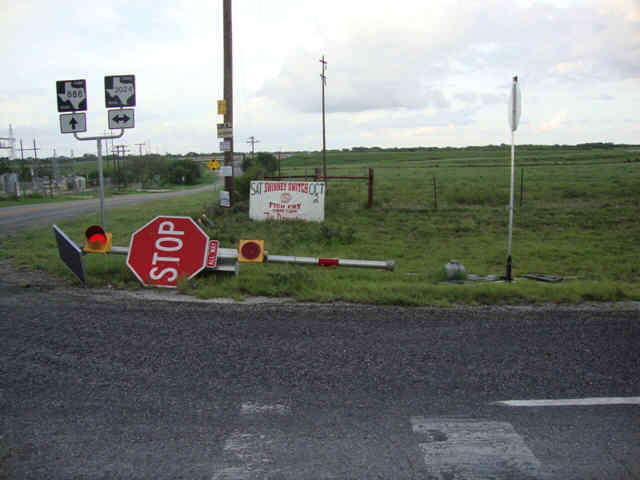
| Swinney Switch Damage Photos | Robstown Damage Photos |
 |
 |
| Orange Grove Damage Photos | Kingsville Damage Photos |
 |
| Bishop Damage Photos |
PRELIMINARY LOCAL STORM REPORT...SUMMARY
NATIONAL WEATHER SERVICE CORPUS CHRISTI TX
947 AM CDT TUE SEP 07 2010

..TIME...   ...EVENT...      ...CITY LOCATION...     ...LAT.LON...
..DATE...   ....MAG....      ..COUNTY LOCATION..ST.. ...SOURCE....
            ..REMARKS..

1115 AM     STORM SURGE      2 SE PORT ARANSAS       27.81N 97.06W
09/06/2010  E2.15 FT         NUECES             TX   EMERGENCY MNGR

            HIGH TIDES HAVE BEEN OBSERVED ALONG NORTH PADRE ISLAND
            AND MUSTANG ISLAND...WITH WATER REACHING THE DUNES IN
            SEVERAL LOCATIONS.

1230 PM     STORM SURGE      1 SW PORTLAND           27.87N 97.34W
09/06/2010  E2.00 FT         SAN PATRICIO       TX   DEPT OF HIGHWAYS

            DPS REPORTED WATER OVER THE ROAD AT INDIAN POINT.

1245 PM     STORM SURGE      2 SW INGLESIDE          27.85N 97.22W
09/06/2010  E2.00 FT         SAN PATRICIO       TX   DEPT OF HIGHWAYS

            DPS REPORTED WATER OVER THE ROAD AT INGLESIDE BY THE BAY.


0430 AM     TROPICAL STORM   BISHOP                  27.58N 97.80W
09/07/2010                   NUECES             TX   TRAINED SPOTTER

            SPOTTER REPORTED ROOF DAMAGE TO A HOME ON ALAMO STREET IN
            BISHOP.

0447 AM     TROPICAL STORM   KINGSVILLE              27.51N 97.86W
09/07/2010                   KLEBERG            TX   AWOS

            WIND GUST OF 50 KNOTS REPORTED AT KINGSVILLE AWOS.

0500 AM     TROPICAL STORM   KINGSVILLE              27.51N 97.86W
09/07/2010                   KLEBERG            TX   EMERGENCY MNGR

            KLEBERG COUNTY EM REPORTS THAT THE WEST SIDE OF THE CITY
            OF KINGSVILLE LOST POWER.

0531 AM     TROPICAL STORM   KINGSVILLE              27.51N 97.86W
09/07/2010                   KLEBERG            TX   ASOS

            WIND GUST TO 62 MPH REPORTED AT NAS KINGSVILLE AND
            SUSTAINED AT 43 MPH.

0540 AM     TROPICAL STORM   ALICE                   27.76N 98.07W
09/07/2010                   JIM WELLS          TX   ASOS

            54 MPH WIND GUST RECORDED AT ALICE ASOS.

0545 AM     TROPICAL STORM   ROBSTOWN                27.80N 97.66W
09/07/2010                   NUECES             TX   MESONET

            ROBSTOWN RECORDED A 52 MPH WIND GUST.

0550 AM     TROPICAL STORM   2 E KINGSVILLE          27.51N 97.83W
09/07/2010                   KLEBERG            TX   TRAINED SPOTTER

            SPOTTER REPORTS POWER OUTAGES IN KINGSVILLE. LARGE TREE
            LIMBS ARE DOWN AS WELL AS MULTIPLE FENCES BLOWN OVER.
            SPOTTERS HOME WEATHER STATION RECORDED A 58 MPH WIND
            GUST.

0600 AM     TROPICAL STORM   CORPUS CHRISTI          27.77N 97.50W
09/07/2010                   NUECES             TX   ASOS

            CORPUS CHRISTI INTERNATIONAL AIRPORT ASOS GUSTED TO 53
            MPH. SUSTAINED WINDS 40 MPH.

0607 AM     TROPICAL STORM   CORPUS CHRISTI          27.77N 97.50W
09/07/2010                   NUECES             TX   ASOS

            55 MPH WIND GUST RECORDED AT CORPUS CHRITI INTL ASOS.
            OVER 2300 CUSTOMERS CURRENTLY WITHOUT POWER IN NUECES
            COUNTY AND OVER 4300 IN KLEBERG COUNTY.

0625 AM     TROPICAL STORM   ALICE                   27.76N 98.07W
09/07/2010                   JIM WELLS          TX   NEWSPAPER

            POWER LINES REPORTED DOWN IN ALICE ALONG WITH NUMEROUS
            TREE LIMBS. SOME SIGNS ALSO BLOWN DOWN.

0658 AM     TROPICAL STORM   ORANGE GROVE            27.96N 97.94W
09/07/2010                   JIM WELLS          TX   ASOS

            54 MPH WIND GUST AT ORANGE GROVE. POWER LINES AND LARGE
            TREE LIMBS REPORTED DOWN.

0815 AM     TROPICAL STORM   LAGARTO                 28.09N 97.93W
09/07/2010                   LIVE OAK           TX   TRAINED SPOTTER

            SPOTTER ESTIMATED WIND GUSTS OF AT LEAST 70 MPH NEAR THE
            SOUTH SIDE OF LAKE CORPUS CHRISTI.

0823 AM     TROPICAL STORM   4 NW MATHIS             28.13N 97.87W
09/07/2010                   LIVE OAK           TX   TRAINED SPOTTER

            SPOTTER MEASURED WIND GUST OF 70 MPH AT THE INTERSECTION
            OF INTERSTATE 37 AND FM 888.

0830 AM     TROPICAL STORM   2 NW LAKESIDE           28.12N 97.88W
09/07/2010                   LIVE OAK           TX   TRAINED SPOTTER

            TREE FELL THROUGH A HOUSE IN swinneyswitch_0 SWITCH. ALSO REPORTS
            OF OTHER TREES DOWN ACROSS THE SOUTHERN PORTION OF LIVE
            OAK COUNTY.

0909 AM     FLASH FLOOD      INEZ                    28.88N 96.78W
09/07/2010                   VICTORIA           TX   TRAINED SPOTTER

            FLOODING ALONG BEN BOLT ROAD IN INEZ.
| Land Location | Peak Wind (mph) | Marine Location | Peak Wind (mph) |
|---|---|---|---|
| Kingsville NAS | 63 | Mustang Oil Platform | 68 |
| Corpus Christi Intl Airport | 55 | Port Aransas | 60 |
| Alice | 54 | Baffin Bay | 55 |
| Orange Grove | 54 | South Bird Island | 55 |
| Rockport | 52 | Port OConnor | 55 |
| Robstown | 52 | Bob Hall Pier | 54 |
| Corpus Christi NAS | 52 | Buoy 42020 | 49 |
| Beeville | 49 | Rockport NOS | 48 |
| Waldron Field | 47 | Seadrift | 47 |
| Cabaniss Field | 47 | Nueces Delta Watershed | 46 |
| Matagorda Island RAWS | 47 | ||
| Ingleside | 46 | ||
| Victoria | 45 | ||
| George West RAWS | 45 | ||
| Aransas National Wildlife Refuge RAWS | 44 | ||
| Port Lavaca | 38 | ||
| Victoria RAWS | 36 | ||
| McMullen Target Range | 30 |

| Storm Total Rainfall for Hermine |
| Location | Inches | Location | Inches |
|---|---|---|---|
| Austwell 6 SSE | 7.51 | Refugio 5 N | 3.94 |
| Victoria 4 ENE | 7.34 | 4 WNW CC NAS | 3.88 |
| Victoria 2 W | 7.30 | Aransas Pass 2 NW | 3.74 |
| Bloomington 2 NNW | 7.21 | Orange Grove 8 WNW | 3.53 |
| Victoria 1 E | 6.92 | Rockport | 3.52 |
| Telferner 3 N | 6.84 | San Diego 1 SW | 3.50 |
| Victoria 4 NNW | 6.80 | Flour Bluff 4 WNW | 3.39 |
| Austwell | 6.74 | Sandia 2 NNE | 3.38 |
| Placedo 4 N | 6.71 | Corpus Christi 6 E | 3.38 |
| Victoria Airport | 6.68 | Ricardo 2 ENE | 3.30 |
| Fannin 6 ESE | 6.56 | Corpus Christi NAS | 3.24 |
| Seadrift 3 NNW | 6.25 | Kingsville 1 E | 3.24 |
| Victoria 2 NNW | 6.21 | Corpus Christi 3 NE | 3.18 |
| Seadrift 4 ENE | 6.08 | Corpus Christi 7 ESE | 3.11 |
| Rockport 1 N | 6.07 | Corpus Christi 5 ESE | 3.07 |
| Nursery 5 W | 6.00 | Ben Bolt 5 nnw | 3.06 |
| Victoria 2 S | 5.99 | Kingsville 3 NNW | 3.04 |
| Fulton 2 W | 5.98 | Flour Bluff 2 WNW | 2.97 |
| Fannin 6 WNW | 5.98 | 7 W CC NAS | 2.89 |
| Telferner 4 S | 5.88 | George West 2 S | 2.69 |
| Fannin 3 ENE | 5.75 | Odem 3 ESE | 2.68 |
| Schroeder 1 NE | 5.57 | Normanna 6 S | 2.60 |
| Goliad | 5.51 | Ricardo 5 E | 2.58 |
| Victoria 3 NW | 5.50 | Beeville 7 ESE | 2.48 |
| Rockport 2 S | 5.36 | Portland 1 NW | 2.39 |
| Fulton 2 WNW | 5.21 | George West 3 NNW | 2.35 |
| Port Lavaca 2 WSW | 4.93 | Corus Christi Intl Airport | 2.35 |
| Weesatche 5 NNE | 4.84 | Corpus Christi 1 NNW | 2.29 |
| Goliad 4 NW | 4.82 | Flour Bluff 1 N | 2.26 |
| Port Aransas 1 ENE | 4.64 | Robstown 1 SSW | 2.21 |
| Weesatche 1 ENE | 4.52 | Flour Bluff 14 S | 2.10 |
| Flour Bluff 5 ESE | 4.46 | Three Rivers 8 NNE | 2.08 |
| Port Aransas 3 SSE | 4.46 | Bishop 2 NW | 1.98 |
| Flour Bluff 5 ESE | 4.45 | Loma Alta 5 N | 1.80 |
| Goliad 1 WSW | 4.43 | Calliham 3 NW | 1.76 |
| Goliad 2 SE | 4.28 | Three Rivers 5 W | 1.26 |
| Orange Grove 3 NNW | 4.15 | Cross | 1.21 |
| St. Paul 3 S | 4.00 | Cotulla | 0.98 |
| Rainfall Totals from 700 PM CDT 9/5/10 through 700 AM CDT 9/8/10. |

